• About The Project
  • Palestine in Century
  • Selected Maps
  • Glossary
  • About ARIJ
  • About LRC
  • By Year
    • Case Studies By Year
    • Daily Report By Year
Friday, May 9, 2025
POICA
No Result
View All Result
  • Home
  • Settlements
    • New Israeli Settlements
    • Settlement Expansion
  • Israeli Violations
    • Agriculture
    • Confiscation
    • Demolition
    • Environment
    • Eviction of Palestinians
    • Settlers Attacks
  • Bypass Roads
  • Israeli Plans
  • Segregation
    • Checkpoints
    • Closure
    • Separation Plans
  • Military Orders
  • Reports
    • Daily Report
    • Monthly Report
    • Quarterly Report
No Result
View All Result
POICA
No Result
View All Result

Opening new colonial road for Alon Moreh colony at the expense of Deir Al-Hatab village

March 2, 2017
in Bypass Roads
Opening new colonial road for Alon Moreh colony at the expense of Deir Al-Hatab village
  • Violation: opening colonial road
  • Location:  Deir AL-Hatab- Nablus governorate
  • Date: October 19, 2016
  • Perpetrators: Alon Moreh colonists
  • Victims:  farmers from the village

Details:

 Colonists of Alon Moreh colony were reported to open new colonial road (2 km* 6m) in Deir Al-Hatab area known as Ras Al-Ain.

According to the field visits conducted by Land Research Center in the area, the area of confiscated lands for the end of opening the new road totaled 15 dunums.

The chairman of Deir Al-Hatab village council, Abdelkarim Hussein, told Land Research Center the following:

"The targeted area is 1km away from the village's houses; it is declared inaccessible due to its proximity to the colony of Alon Moreh. Farmers wait impatiently for the season of olive harvesting to be allowed to enter their lands, which are threatened of confiscation at anytime. Noteworthy, Ras Al-Ain totals around 800 dunums"

He also added:

" On November 19, 2016, farmers headed to the area after obtaining a special permit from the occupation's side. Surprisingly, farmers were shocked to see that colonists embarked on opening a colonial road as a step to establish a new outpost in the area. Colonists took advantage of farmers inability to access their lands to take them over and start their plan of a new outpost. Israeli-Palestinian District of Coordination Office DCO was immediately contacted and a halt on construction works on the road was issued".

hefetz1

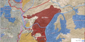
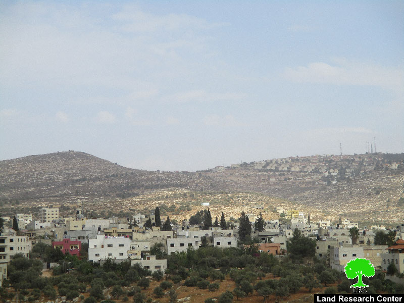
Photo 1: Alon Moreh colony and the targeted area

Hussein showed concerns that colonists are likely to re-open the road but after the olive harvesting season is over. This time, the action will be supported by the commanders of Israeli army, whom are close friends for colonists.

The plan to takeover areas next to Alon Moreh colony is not recent. Lands takeover escalated in 2014; colonists did so in cooperation and help of the Israeli government, which declare Palestinian lands inaccessible so that colonists can benefit them.

The village council of the area submitted a complaint to Israel Supreme Court, explaining the colonists' violations and attacks they witness but to no avail.


Deir al Hatab – an Overview:

Deir al Hatab is located 5.5 km to the east of Nablus city; it is total area is 10875 dunums including 318 dunums of built-up area.

The village's population has reached 2213 people (according to PBS statistics of 2007).

The village has lost 389 dunums of its total area to Israeli colonial activities.

It is surrounded by a number of historical sites and ruins.


Prepared by
 The Land Research Center
LRC


Recommended For You

شق طريق استيطاني جديد يهدد سبل العيش في قرية بردلة

by arij
January 13, 2025
0
New Israeli Settlement Road Construction and Its Impact on the Village of Bardala in the Jordan Valley

المكان: تجمع بردلة- محافظة طوباس/الأغوار الزمان: سبتمبر 2024 الجهة المتضررة: أهالي قرية بردلة والقرى المجاورة الجهة المعتدية: ما تسمى بالإدارة المدنية الاسرائيلية الانتهاك: شق طريق استيطاني تفاصيل الانتهاك:...

Read moreDetails

New Israeli Settlement Road Construction and Its Impact on the Village of Bardala in the Jordan Valley

by arij
December 31, 2024
0
New Israeli Settlement Road Construction and Its Impact on the Village of Bardala in the Jordan Valley

  The construction of new settlement infrastructure in the occupied Palestinian territories has profound implications for local communities, threatening livelihoods, increasing isolation, and impairing socio-economic vulnerabilities. This case...

Read moreDetails

الطرق الالتفافية الاسرائيلية وأثرها على البيئة الفلسطينية

by arij
January 16, 2024
0
الطرق الالتفافية الاسرائيلية وأثرها على البيئة الفلسطينية

  الاعتداءات الإسرائيلية على الفلسطينيين لا تقتصر على التنكيل بالافراد، أو وضع القيود على الحركة والتنقل، أو استهداف المنازل والمنشات، أو مصادرة الأراضي، أو نهب الموارد والمصادر الطبيعية،...

Read moreDetails

Israeli Colonists Take Over an Agricultural Road in Ya’bad town / Jenin Governorate

by arij
January 12, 2022
0
Israeli Colonists Take Over an Agricultural Road in Ya’bad town / Jenin Governorate

  Violation: Taking over an agricultural road for the favor of colonization. Location: Ya’bad town / Jenin Governorate. Date: October 17th 2021. Perpetrators: Mevo Dotan Colony. Victims: Farmers...

Read moreDetails

New Colonial road to Be Opened on Sarta Village lands / Salfit Governorate

by arij
July 17, 2021
0
New Colonial road to Be Opened on Sarta Village lands / Salfit Governorate

  Violation: Opening a new Colonial Roads. Location: Sarta village/ Salfit Governorate. Date: June 1st 2021. Perpetrators: The Israeli Illegal Industrial Colony (Barkan). Victims: Farmers from the village....

Read moreDetails
Next Post

ARIJ Daily Report - Tue, 21th 11 2016

LATEST NEWS

الأراضي الفلسطينية بين الذرائع الأمنية والأطماع الاستيطانية – “الأمن، الآثار، والطبيعة كحجج لاقتلاع الفلسطينيين من أراضيهم”

by arij
April 15, 2025
0

........................................................

الطرق الالتفافية الاسرائيلية وأثرها على البيئة الفلسطينية

انتهاك للطبيعة والهوية في الأراضي الفلسطينية المحتلة

by arij
March 17, 2025
0

........................................................

Israel Advances Settlement Plan on Ancient Olive Groves on lands of Beit Jala city, Violating International Law and depriving Palestinians their lands

إسرائيل تمضي قدمًا في مخطط استيطاني جديد على أراضي مدينة بيت جالا، في انتهاك للقانون الدولي وحرمان الفلسطينيين من أراضيهم

by arij
April 29, 2025
0

........................................................

Israel Advances Settlement Plan on Ancient Olive Groves on lands of Beit Jala city, Violating International Law and depriving Palestinians their lands

Israel Advances Settlement Plan on Ancient Olive Groves on lands of Beit Jala city, Violating International Law and depriving Palestinians their lands

by arij
April 29, 2025
0

........................................................

flag_yellow_lowEU-PfP-Logo

This website has been produced with the assistance of the European Union. The contents of this publication are the sole responsibility of ARIJ & LRC and can in no way be taken to reflect the views of the European Union.

© 2025 Copyright ARIJ . All Rights reserved. .

No Result
View All Result
  • Home
  • Settlements
    • New Israeli Settlements
    • Settlement Expansion
  • Israeli Violations
    • Agriculture
    • Confiscation
    • Demolition
    • Environment
    • Eviction of Palestinians
    • Settlers Attacks
  • Bypass Roads
  • Israeli Plans
  • Segregation
    • Checkpoints
    • Closure
    • Separation Plans
  • Military Orders
  • Reports
    • Daily Report
    • Monthly Report
    • Quarterly Report

© 2025 Copyright ARIJ . All Rights reserved. .