• About The Project
  • Palestine in Century
  • Selected Maps
  • Glossary
  • About ARIJ
  • About LRC
  • By Year
    • Case Studies By Year
    • Daily Report By Year
Thursday, October 2, 2025
POICA
No Result
View All Result
  • Home
  • Settlements
    • New Israeli Settlements
    • Settlement Expansion
  • Israeli Violations
    • Agriculture
    • Confiscation
    • Demolition
    • Environment
    • Eviction of Palestinians
    • Settlers Attacks
  • Bypass Roads
  • Israeli Plans
  • Segregation
    • Checkpoints
    • Closure
    • Separation Plans
  • Military Orders
  • Reports
    • Daily Report
    • Monthly Report
    • Quarterly Report
No Result
View All Result
POICA
No Result
View All Result

Israel Demolition and Evacuation Orders targeted lands and structures in Qusra town in Nablus Governorate

August 6, 2016
in Military Orders
Israel Demolition and Evacuation Orders targeted lands and structures in Qusra town in Nablus Governorate

On the 2nd of August 2016, the Israeli Civil Administration escorted by the Israeli Army stormed the Palestinian town of Qusra, south of Nablus city, and handed out military orders to demolish two agricultural water wells and to evacuate more than 50 dunums of Palestinian lands planted with 50 olive trees and used for the construction of 5 water wells and agricultural rooms….

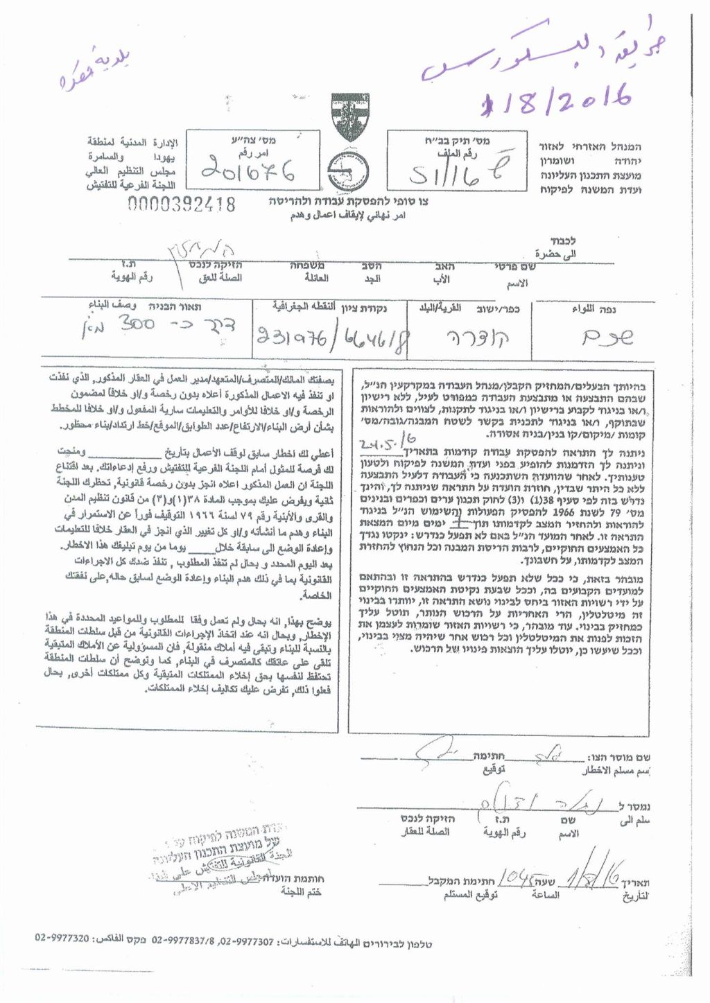
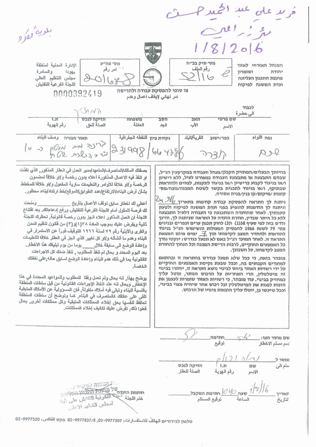
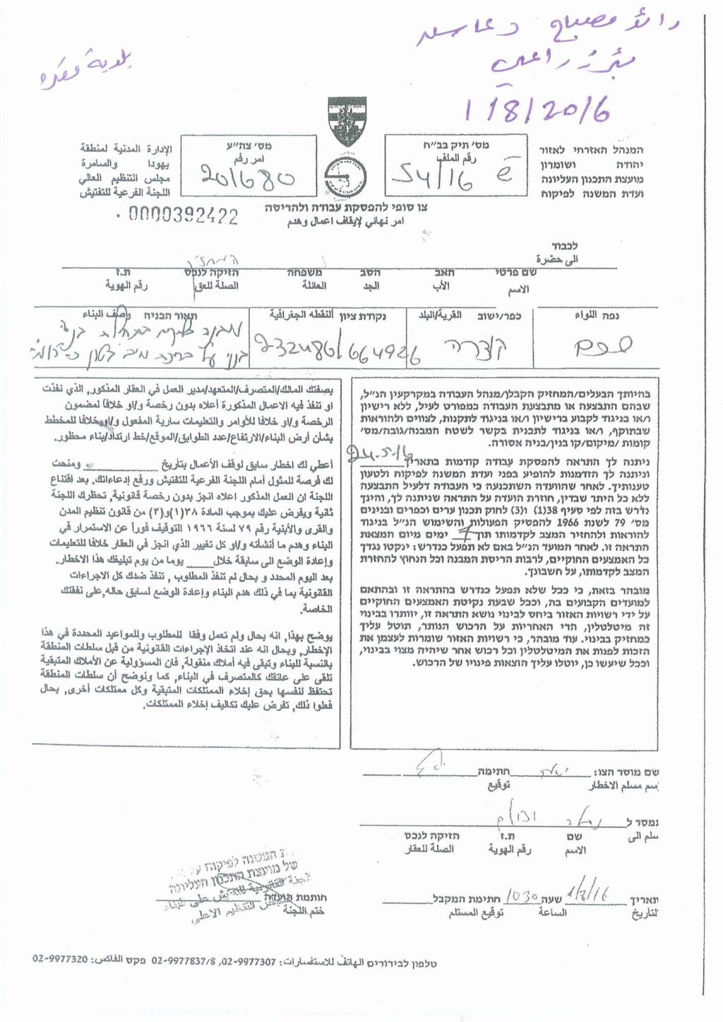
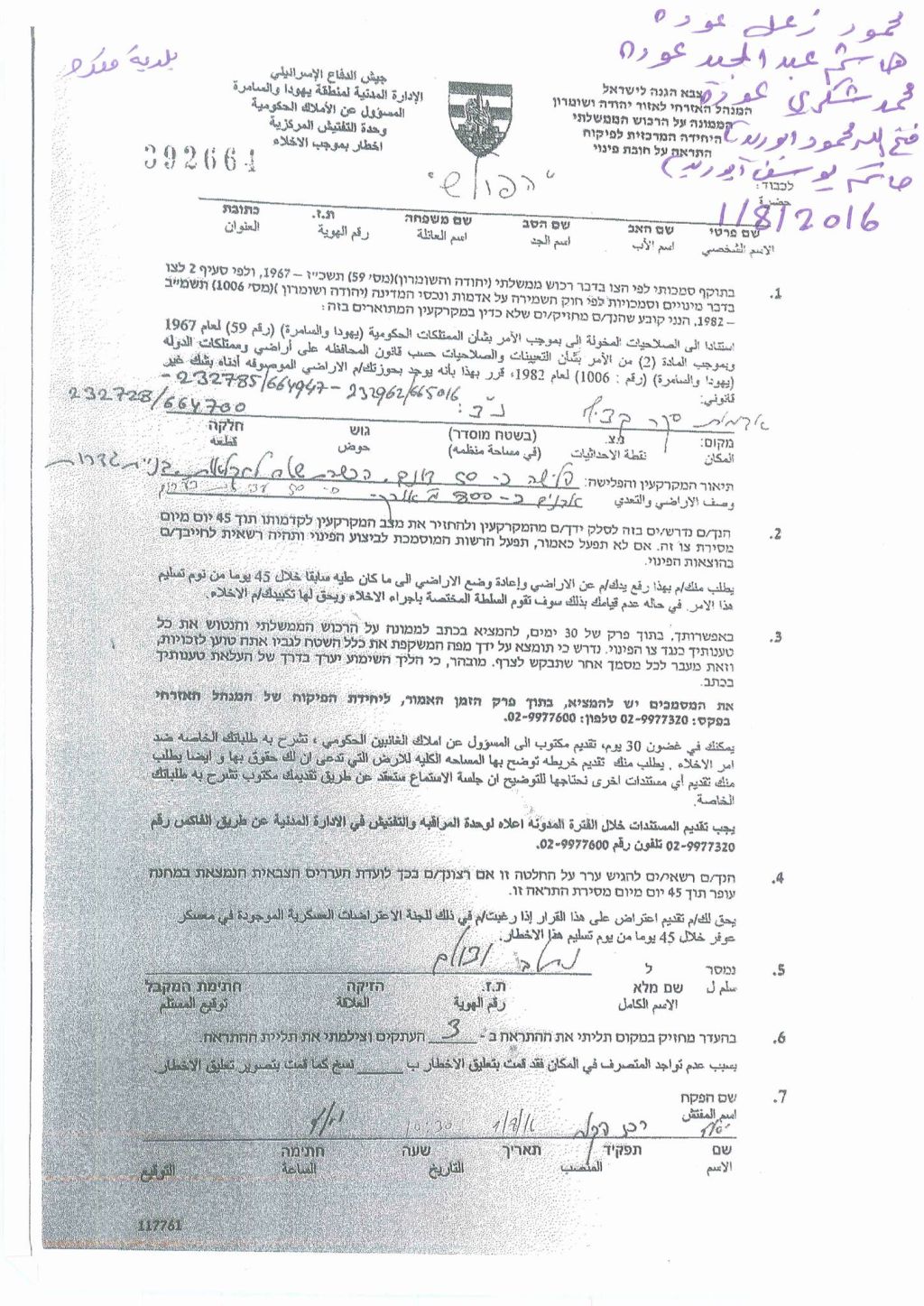
The demolition orders, claimed that the targeted water wells built without permits from the Israeli Authorities, and for that,  the demolition orders gave the owners of the water wells 7 days to demolish the targeted wells or to get the building permits form the Israeli Civil Administration. While the evacuation order claimed that the targeted land which used to construct  the 5 water wells and rooms, classified by the Israeli Authorities as “State land”. The order gave the owners 45 days to demolish all the structures build in the targeted land.

Details about the targeted structures

 Military Orders No.

Type of orders

Type of  targeted structures

Name of the owners

201678

Demolition order

Agricultural water well

Fared Ali Abed Al Hamed Hassan

201680

Demolition order

Agricultural water well

Raid Musbah Da’as

201676

Demolition order

Road (length = 300 meters) established on 1.5 dunums of land

Qusra Municipality

392661

Evacuation order

50 dunums of land, planted with 50 trees and 800 square meters structures

Mahmoud Za’al Odeh

Hatim Yousif Abu Ridah

Hashim Abed Al Majed Odeh

Mohammad Shukri Odeh

Fathalla Mahmoud Abu Ridah

201676201678201680392661Map

Photocopies for the military orders


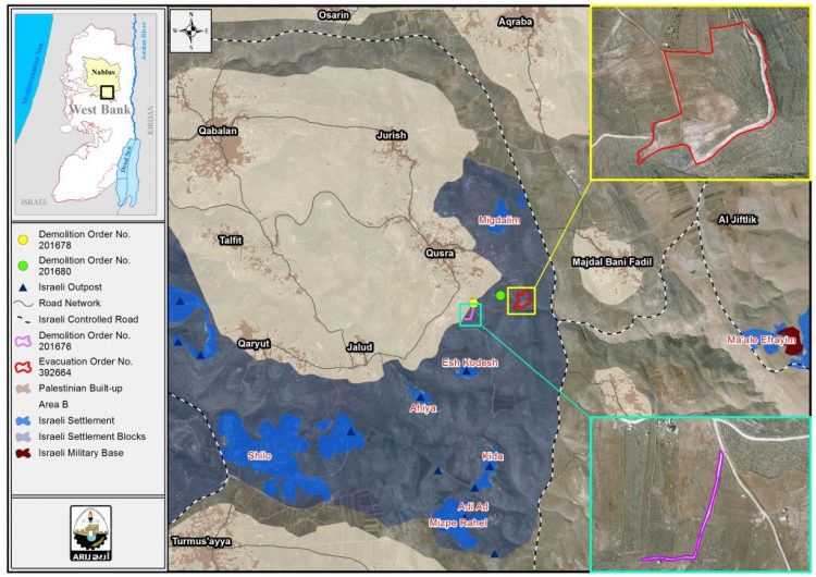
An analysis done by the Geo-Informatics department in the Applied Research Institute- Jerusalem (ARIJ), showed that the targeted  land and water wells located in area classified as “Area C” (according to Oslo agreement, 1995), which it under the control of the Israeli Occupation Authorities. In the area “C” the Israeli Authorities used to prevent the Palestinians from building their houses or any other structures they needs, without getting the permits from the Israeli Civil Administration. As a matter of fact the process of issuing building permits from the “Israeli Civil Administration”  is sophisticated, and costs a lot of time and money where most of the Palestinian requests for issuing such permits are most often rejected.

Furthermore, the analysis showed that the targeted lands (about 53.4 dunums ) are not classified as “State land” as the Evacuation order claimed.

Moreover, the targeted land and structures located within the “ Israeli “corridor of Shilo” which includes a number of  illegal Israeli settlements and outposts, military bases and Israeli road network, and also, part of Palestinian towns and villages, where hundreds of Palestinian lives ….

It is worth to mention that the corridors areas were de facto created as a result of the construction of the Segregation Wall where the Israeli-created corridors area link between  the Eastern segregation zone (the area located along the Palestinian- Jordanian borders)  and the Western segregation zone (the area located between the path of the Segregation wall and the Armistice Line 1949 ‘Green line”)

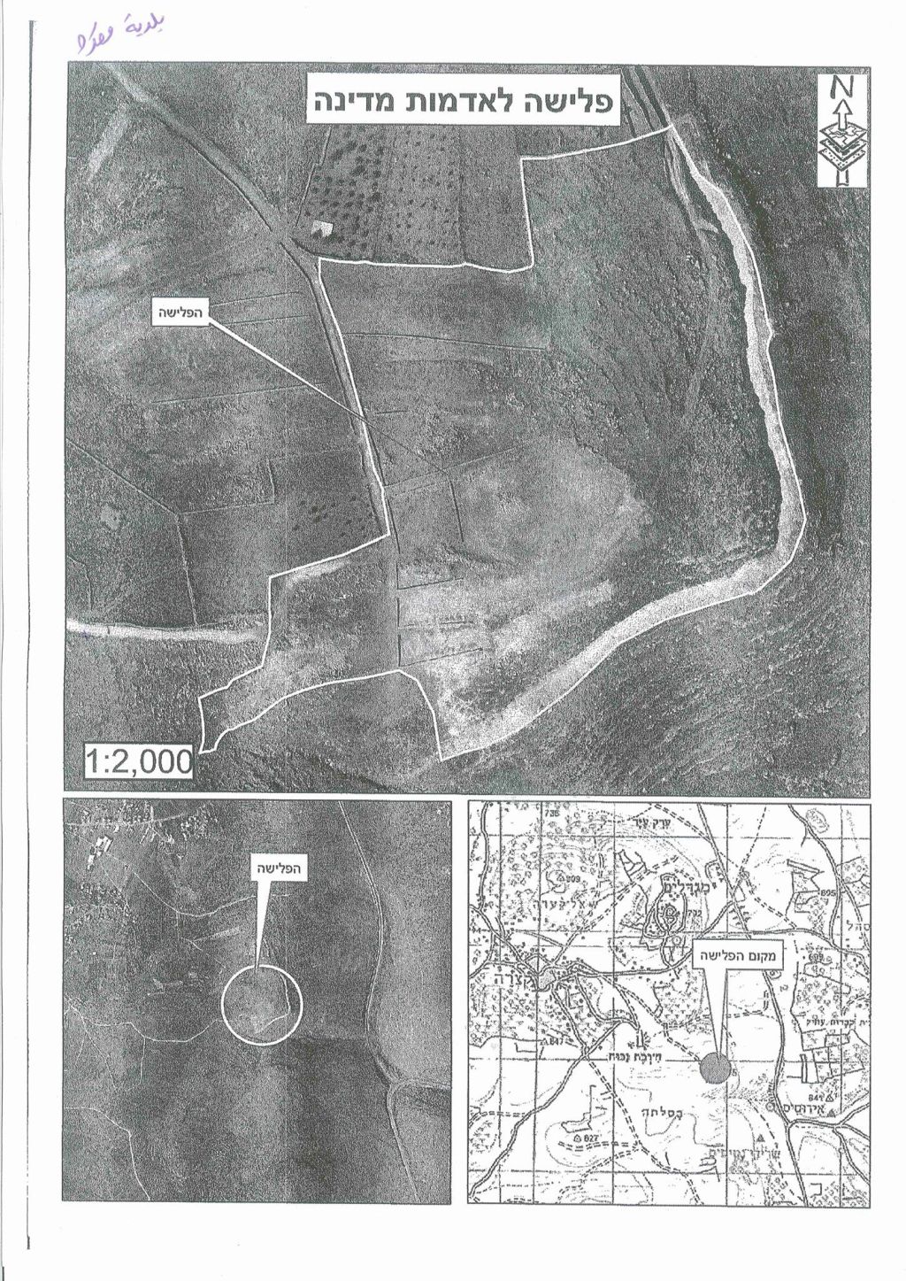
Furthermore, the Israeli colonial corroders is a very strategic area for the Israeli Occupation, where it keen to keep its control over these areas for “security and colonial considerations” and mainly to find a geographical contiguity between the Israeli settlements and outpost in all parts on the oPt. See the map below:


Qusra

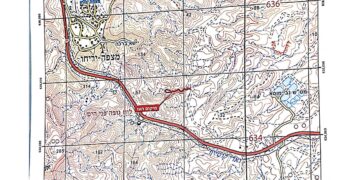
Map showed the location of the targeted water wells and the agricultural land


Actually, This is not the first time that the Israeli Authorities targeted the residents of Qusra town, south of Nablus governorate with the demolition or halt construction orders, where from the beginning of 2016, the Israeli Civil Administration issued tens of military orders that targeted structures in Qusra town, under the claim of lacking building permits. Following are part of the case studies prepared about the military orders that targeted structures in Qusra town:

  • “ A series of halt-of-construction orders in three Palestinian communities in southern Nablus Governorate” …  https://poica.org/details.php?Article=9653
  • Funded by the Dutch Representative Office
  • The Israeli occupation notifies agricultural structures of Stop-Work in Qusra town…. http://www.old.poica.org/details.php?Article=9485
  • Demolition and stop-work orders on structures in Qusra village.. http://www.old.poica.org/details.php?Article=9051
  • The Israeli occupation notifies structures with demolition in the Nablus village of Qusra…. http://www.old.poica.org/details.php?Article=7948


Qusra Town:

Qusra is a Palestinian village in the Nablus Governorate, located southeast of Nablus City. It is bordered by Majdal Bani Fadil and Duma to the east, Jurish to the north, Talfit to the west, and Jalud to the south. For more information about Qusra town, check the link below:  http://vprofile.arij.org/nablus/pdfs/vprofile/Qusra_vp_en.pdf


Prepared By  
The Applied Research Institute – Jerusalem
ARIJ

Recommended For You

سلطات الاحتلال الإسرائيلي تستغل ‘المنفعة العامة’ لنهب الموارد الفلسطينية

by arij
September 30, 2025
0
سلطات الاحتلال الإسرائيلي تستغل ‘المنفعة العامة’ لنهب الموارد الفلسطينية

في الاول من شهر ايلول من العام 2025، نشرت الإدارة المدنية الإسرائيلية، الذراع الأيمن لحكومة الاحتلال الإسرائيلي أمرا عسكريا جديدا تحت عنوان " أمر ءبشأن قانون الأراضي (الاستملاك...

Read moreDetails

The Occupation Targets the Village of Raba Southeast of Jenin with Military Orders and Seizes Vast Areas of Its Lands

by arij
September 13, 2025
0
الاحتلال يستهدف بأوامر عسكرية قرية رابا جنوب شرق جنين ويصادر مساحات واسعة من أراضيها

 The Israeli occupation Army have continued their policy of plundering Palestinian lands, as their bulldozers leveled wide areas of agricultural land in the village of Raba, southeast of...

Read moreDetails

الاحتلال يستهدف بأوامر عسكرية قرية رابا جنوب شرق جنين ويصادر مساحات واسعة من أراضيها

by arij
September 13, 2025
0
الاحتلال يستهدف بأوامر عسكرية قرية رابا جنوب شرق جنين ويصادر مساحات واسعة من أراضيها

  واصلت قوات الاحتلال الإسرائيلي سياسة نهب الأراضي الفلسطينية، حيث أقدمت آلياتها على تجريف أراض زراعية واسعة في قرية رابا جنوب شرق محافظة جنين، تمهيدا لشق شارع عسكري...

Read moreDetails

Nablus Governorate’s Archaeological Sites Face Israeli Expropriation Plans

by arij
September 11, 2025
0
” المواقع الأثرية في محافظة نابلس… ساحة مفتوحة أمام مخططات المصادرة الإسرائيلية “

On 10 August, 2025, the Israeli Civil Administration (ICA), issued a booklet of military orders signed by the head of the so-called ‘Israeli Civil Administration’ in the occupied...

Read moreDetails

” المواقع الأثرية في محافظة نابلس… ساحة مفتوحة أمام مخططات المصادرة الإسرائيلية “

by arij
August 26, 2025
0
” المواقع الأثرية في محافظة نابلس… ساحة مفتوحة أمام مخططات المصادرة الإسرائيلية “

في العاشر من شهر اب من العام 2025, أصدرت الإدارة المدنية الإسرائيلية كراسة أوامر عسكرية موقعة من قبل رئيس ما يسمى "بالإدارة المدنية الإسرائيلية" في الضفة الغربية المحتلة,...

Read moreDetails
Next Post

ARIJ Daily Report - Sat, 6th 08 2016

LATEST NEWS

Annexation of the Jordan Valley: Implications for the Two-State Solution and Regional Stability

Annexation of the Jordan Valley: Implications for the Two-State Solution and Regional Stability

by arij
September 29, 2025
0

........................................................

Isolation of Three Villages Northwest of Jerusalem: Silent Annexation Creeps toward the Capital

عزل ثلاث قرى فلسطينية شمال غرب مدينة القدس: الضم الاسرائيلي الصامت يزحف نحو محيط العاصمة

by arij
September 24, 2025
0

........................................................

Isolation of Three Villages Northwest of Jerusalem: Silent Annexation Creeps toward the Capital

Isolation of Three Villages Northwest of Jerusalem: Silent Annexation Creeps toward the Capital

by arij
September 24, 2025
0

........................................................

سياسات التهويد في القدس: من السيطرة المكانية إلى طمس الهوية عبر التسمية

سياسات التهويد في القدس: من السيطرة المكانية إلى طمس الهوية عبر التسمية

by arij
September 23, 2025
0

........................................................

flag_yellow_lowEU-PfP-Logo

This website and its content were initiated in 1993 by the Applied Research Institute – Jerusalem (ARIJ) and the Land Research Center (LRC) with the support from the European Union up until 2023. Since then, the Applied Research Institute – Jerusalem (ARIJ) has taken over the continued development and maintenance of the website. The views expressed remain solely those of ARIJ) and do not necessarily reflect those of the European Union.

© 2025 Copyright ARIJ . All Rights reserved. .

No Result
View All Result
  • Home
  • Settlements
    • New Israeli Settlements
    • Settlement Expansion
  • Israeli Violations
    • Agriculture
    • Confiscation
    • Demolition
    • Environment
    • Eviction of Palestinians
    • Settlers Attacks
  • Bypass Roads
  • Israeli Plans
  • Segregation
    • Checkpoints
    • Closure
    • Separation Plans
  • Military Orders
  • Reports
    • Daily Report
    • Monthly Report
    • Quarterly Report

© 2025 Copyright ARIJ . All Rights reserved. .