On December 1, 2015, the Israeli Occupation Army handed over Palestinian residents from Surif and Al-Jab’a south east of Bethlehem and north of Hebron Governorates a military confiscation order. The military order which is holding No. (15/12/T), extending the expropriation of 243.5 dunums from the Palestinian lands on Jab’a and Surif for the purpose of the construction of the Segregation Wall sections in the aforementioned villages.
The military order is signed by “Roni Noma” the commander of the Israeli Occupation Forces in the West Bank where the order was signed in September 7, 2015 , while handed over to the Palestinian resident on December 1, 2015 in an attempt to deprive the owners of the targeted lands from submitting legal petitions against the expropriation procedure.
It is worth pointed that the Israeli Army handed over the military order 15/12/T for the first time in July 8, 2012 to be expired on December 31, 2014, while the issued current order extending the confiscation to December, 31, 2017. See the photo copy of the military order :
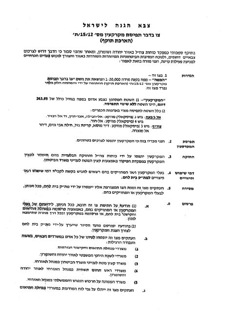
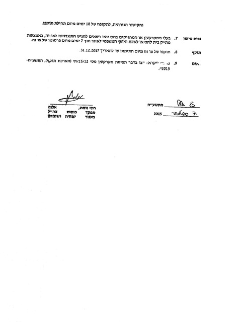
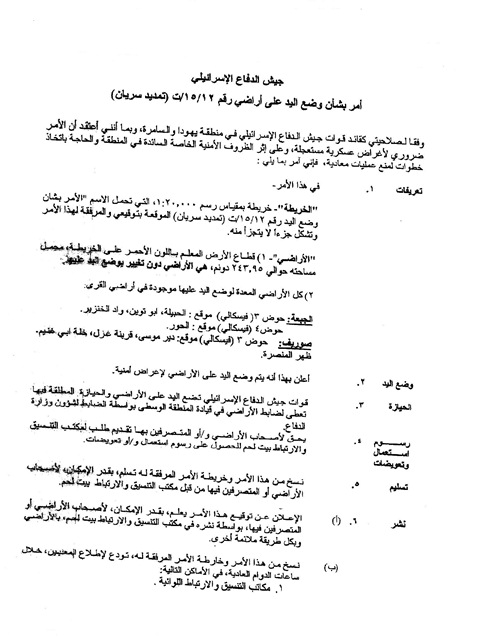
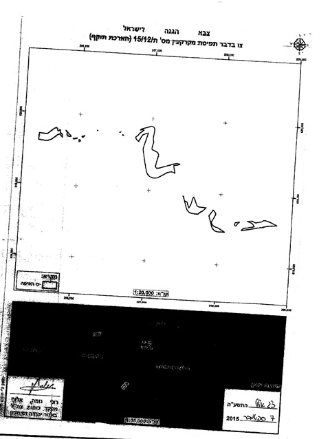
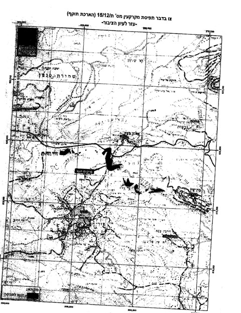
Photo copy for the military order (15/12/T)-(extending validity)
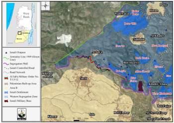
The targeted lands in Surif villages located in the areas of : Deir Mousa- Qareenet Al-Ghazal- Khallet Abu Ghneim- Daher al-Mansara north of Surif , and other area to the south of Al-Jab’a village. See the map below:
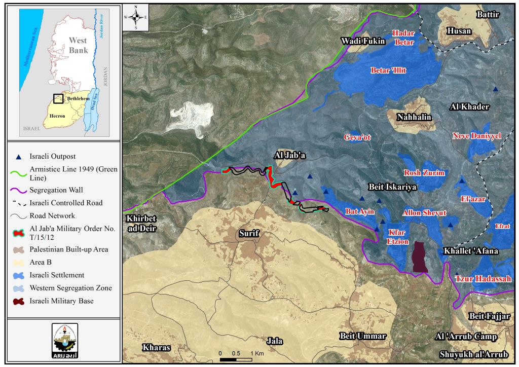
Al Jab'a village is located 12.5 Kilometers to the southwest of Bethlehem city. It is about 1 km from the Green Line (Armistice line of 1949). It is populated by 1100 (PCBS Projections 2015) .Al-Jab’a is bordered by the Gosh Etzion settlement bloc from the north, Surif from the south Khirbet Al-Deir as well as the Green Line from the west , Nahalin town from the northeast.
Surif, is a Palestinian village located about 15 km to the northwest of the city of Hebron. Surif population exceeds 17,000 inhabitants (PCBS Projections 2015). It is bordered by Al-Jab’a as well as the Segregation Wall from the north, Jala, kharas from the south , Khirbet Al-Deir from the west, Gus Etzion settlement bloc from the east and northeast.
It is worth mentioning that on October 17, 2004, the Israeli authorities handed the residents of Al Jab'a and the nearby Surif town military order number (T/74/04) to confiscate 270 dunums of lands (2253 meters length and 271 meters width) for the construction of the Segregation Wall. The lands threatened in Al Jab'a village are located within Block 4, in Al Khur area, whereby the lands of Surif are located within Block 3, in Wad Al -Jurd and block 2, in the areas of Dhaher 'Elin, Dhaher Ader, Ras Hassan, Al- Za'rura and Karnet Al Baluta.
Moreover, the Israeli Occupation Forces handed the residents of the two villages another military order # (T/131/05) to take over 112 dunums of lands with 1,156 meters length and 100 meters width in the areas of Qurnet Ghazal, Khallet Abu Ghuneim, Wadi Abu Rish, Ein Al Biada, and Abu Tweim south of Al Jab'a village. Hundreds of dunums of Olive and Vine trees were seized or isolated behind the already constructed sections of the Wall to the west of the two villages.
Significant Colonial Measures in Al-Jab’a Village
The Segregation Wall in Al-Jab’a village extends 2 km from the land of Jaba'a village in the north western corner of Hebron district and going through the lands of Surif town and Khirbet Al-Deir. The Segregation Wall reaches up to 200 meters into the West Bank, appropriating large areas of Palestinian agricultural land. About 300 dunums (0.3 km2) of Palestinian lands were also confiscated in order to construct the Wall.
About 59% ( 4168 dunums ) of the open space in Al-Jab’a village will be isolated, which will impose pediments to future development of the village. Also the forest that lies on the lands of Al Jab'a will be entirely isolated behind the Wall and the local villagers will no longer be able to access it..
Proposed Trade Passage in the area
On August 22, 2005, the Israeli authorities issued the military order number (158/05/T) stipulated the confiscation of 181 dunums of lands in Al-Jab’a and the nearby village of Surif. The aforementioned military order issued for the pretext of constructing a trade passage in the area. According to the military order 43 dunums of lands are to be taken from Al Jab'a village, 64 dunums from Surif and the rest 3 are located inside the Armistice Line (Green Line).
The site of the proposed border crossing is about 2 km to the east of the Armistice Line (Green Line) and 1 km to the west of Al Jab'a village, where according to the Israeli army, the border crossing will serve as a commercial crossing point between Israel and the occupied territory.
For the Israelis, these crossings will serve as bridges to sell and smuggle Israeli products into the West Bank markets. In the meanwhile, trade between the West Bank and abroad will be tightly controlled by Israel and could be hindered at any moment of time by Israel under any security pretext or as means of political pressure or collective punishment.
To Sum Up
The Israeli confiscation of the Palestinian lands constitute a flagrant and grave breach for the International law rules and conventions (Art. 51 of the 1949 Geneva Convention II –Art. 147 of the 1949 Geneva Convention IV- Art. 53 of the 1949 Geneva Convention IV-Art. 23(g) of the 1899 Hague Regulations – the Universal Declaration of Human Rights Adopted and proclaimed by General Assembly resolution 217 A (III) of, December 10, 1948, Articles 13 and 17 and Article 12 of the International Covenant on Civil and Political Rights, adopted by the General Assembly of the United Nations on 19 December 1966 :-
- Articles 147 of the Fourth Geneva Convention indicated that: Extensive destruction and appropriation of property not justified by military necessity and carried out unlawfully and wantonly. is a grave breach of the Convention.
- Art. 23 of the Hague Convention of 1907 also provides: In addition to the prohibitions provided by special Conventions, it is especially forbidden to destroy or seize the enemy's property, unless such destruction or seizure be imperatively demanded by the necessities of war;.
- Article 53 of the same convention provides that 'any destruction by the Occupying power of real or personal property belonging individually or collectively to private persons, or to the State, or other public authorities or social or cooperative organizations is prohibited, except where such destruction is rendered absolutely necessary by military operations.'
- Article 147 of the convention considers 'extensive destruction and appropriate of property, not justified by military necessity and carried out unlawfully and wantonly' as a grave breach of the Convention and thus constitute a war crime.
- Under the Universal Declaration of Human Rights Adopted and proclaimed by General Assembly resolution 217 A (III) of, December 10, 1948, Article 17 reads: 'No one shall be arbitrarily deprived of his property.' Which means it bans Israel from destroying or confiscating the property of the Palestinians at any case.
- Universal Declaration of Human Rights Article 13: Everyone has the right to freedom of movement and residence within the borders of each State.
- Article 12' of the International Covenant on Civil and Political Right International Covenant on Civil and Political Rights. Adopted by the General Assembly of the United Nations on 19 December 1966: Everyone lawfully within the territory of a State shall, within that territory, have the right to liberty of movement and freedom to choose his residence.
Prepared by:
The Applied Research Institute – Jerusalem