Israel's Yedioth Ahronoth daily newspaper unveiled on the 15th of June 2015 a new settlement project that will target the lands of Kafr Aqab village north of Jerusalem city. The plan is headed by Arieh King, director and founder of the Israel Land Fund (ILF), a man who is devoted to settling Jews in Israel and the occupied Palestinian territory, most specifically in the city of Jerusalem. Note that on the 11th of May 2015, the Israeli “Magistrates” court issued an order to evacuate and demolish seven residential complexes and a vacant land in the village of Kafr Aqab under the pretext of “being owned by Jews since 1971”. The buildings are owned by each of Hamdi Al Rajabi, Jamal Abu Al Leil, Omar Makhlouf, Said and Akram Abu Shalbak, Jaber Khader, Ismail Khader, Adel Abu Dumilleh and Najeh Al Rajabi, and a vacant land owned by Mona Al Hmouz. The court gave the Palestinian families until the beginning of August 2015 to evacuate their properties and demolish them. The targeted buildings are located on the Palestinian side of the wall in the village, but within the Israeli municipal boundary of Jerusalem which was illegally and unilaterally re-drawn after the Israeli occupation of the Palestinian territory in 1967.
Kaf Aqab village and the Israeli Segregation Wall plan
The Israeli Segregation Wall has a negative impact on Kafr 'Aqab Village, where according to the last amendment of the Israeli Segregation Wall published on the webpage of the Israeli Defense Ministry (30th April 2007), the Wall extends 4km over Kafr 'Aqab’s lands and isolates most of the village lands (92% of the total village’s area) by excluding them outside the municipal boundaries of Jerusalem, to become on the eastern side of the Segregation Wall (under the Palestinian National Authority's jurisdiction) and separated from the rest of Jerusalem city. The construction of the wall has stripped off Palestinian Jerusalemites (those holding Jerusalem ID cards – Blue cards) their right to continue living in the city; this is in addition to being forced to access the city of Jerusalem on daily bases through the border crossings which were set up by Israel between the city of Jerusalem and the surrounding Palestinian communities so as not to lose their right of residency in the city.
The old-new settlement plan on lands of Kafr Aqab
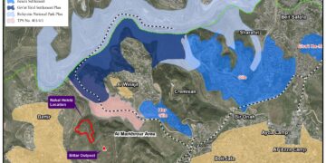
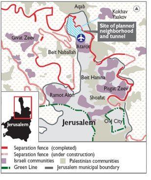
On 28th February 2007, Israel’s Haaretz daily newspaper unveiled the Israeli Ministry of Construction and Housing plan to build a new settlement on lands of Kafr Aqab, near Qalandiya airport, within the Israeli municipal boundaries of Jerusalem. The settlement plan includes the construction of 11,000 settlement units to accommodate Ultra-Orthodox settlers in the city. The new Israeli settlement will be connected with Kokhav Ya'acov settlement and the nearby Beit El settlement bloc[1] east of Ramallah city via an underground tunnel at the expense of Kafr 'Aqab village land. See Photo 1

Photo 1: the new Israeli neighbourhood as published by Haaretz in 2007.
The newspaper indicated that the new neighborhood will be built on land “apparently owned by the Jewish National fund”; however, the construction of the wall has set most of Kafr Aqab lands on the Israeli side, within what became known to Palestinians as the “western segregation zone”, which opened the way for the various settlement foundations/associations to seize lands and properties under various pretexts. Photo 1 indicates that the location that was targeted for settlement expansion back in 2007, is the same location targeted nowadays by Israel Land fund organization.
Kafr Aqab village, Geoghraphy and Denoghraphy
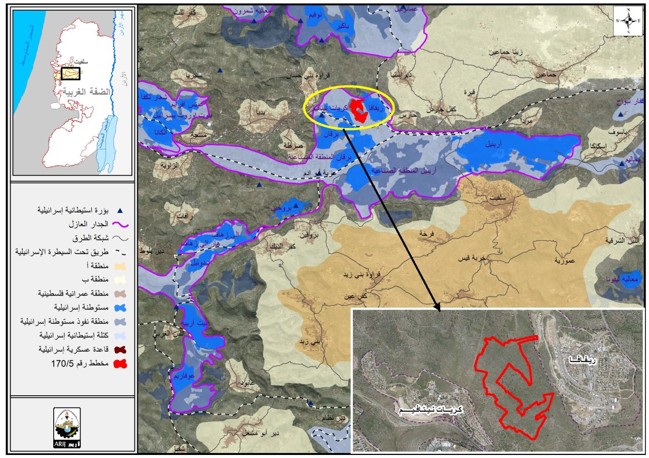
Kafr 'Aqab is a Palestinian village in Jerusalem Governorate located 11.2km north of Jerusalem City. It is bordered the settlement of Kochav Yacoov (Abir Yacov) from the east, the Israeli Segregation Wall from the west, Pesagot settlement and Al Am’ari refugee camp from the north, Ar Ram and Dahiyat Al Barid outskirt and the settlement of Atarot from the south, (ARIJ-GIS Unit, 2015) (See map 1).
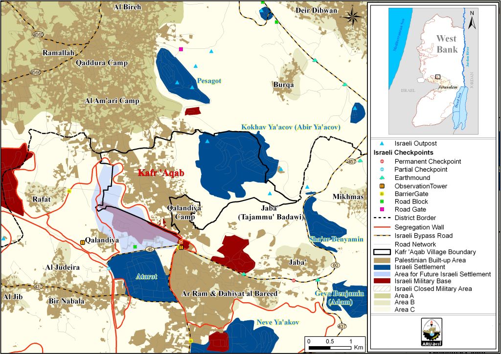
See Map 1: The geopolitics of Kaf Aqab Village
Kafr 'Aqab village spans on 6665 dunums of land in total, of which, 2339 dunums (35.1% of the total area of the village) are located under the control of the Israeli Jerusalem municipality. The remaining 4326 dunums (64.9% of the total area of the village) of Kafr Aqab village land falls under the Oslo II Interim Agreement[2], which divided the West Bank into areas "A"[3], "B"[4] and "C"[5]; thus, designating Kafr Aqab lands as area “C”, where Israel retains full control over security and administrative issues.
To conclude,
The Successive Israeli governments have created numerous obstacles to the development of land in occupied East Jerusalem, allocating large parts of the village territory to the construction of Israeli settlements and classifying other areas as ‘Green Zones’ or National parks where Palestinians are prevented from construction. These policies make Palestinian urbanization and expansion almost impossible, causing significant suffering to the Palestinian population.
Additionally, the Israeli occupation authorities deliberately fail to regulate Palestinian land and neighborhoods in East Jerusalem, and impose endless complex laws and restrictions on construction permits in the city. These policies prevent construction entirely in some areas and incur high costs for those Palestinians applying for construction licenses in others. They force Palestinians to build without permits to house the growing population, meaning that such homes are constantly subject to the threat of demolition.
Without doubt, the Israeli policy of building and expanding settlements sits in the way of peace, and weakens all international and regional efforts to establish a just and lasting peace based on a two-state solution. The various UN resolutions have made it clear that settlement construction in the occupied Palestinian territory is considered a clear violation of international law and human conventions. The UN Security Council Resolution No. 465 Adopted by the Security Council on 1 March 1980, “Determines that all measures taken by Israel to change the physical character, demographic composition, institutional structure or status of the Palestinian and other Arab territories occupied since 1967, including Jerusalem, or any part thereof, have no legal validity and that Israel's policy and practices of settling parts of its population and new immigrants in those territories constitute a flagrant violation of the Fourth Geneva Convention relative to the Protection of Civilian Persons in Time of War and also constitute a serious obstruction to achieving a comprehensive, just and lasting peace in the Middle East;” As well the 'UN Security Council resolution No. 242 of 22 November 1967, which calls for Israel's full withdrawal from the territories occupied by Israel in its aggression in 1967.
[1]located on Kafr 'Aqab village land, east of the Wall (on the Palestinian side)
[2] the Oslo II Interim Agreement was signed on 28th September 1995 between the Palestinian Liberation Organization (PLO) and Israel
[3]Area A: over which the Palestinian National Authority (PNA) has full (security and administrative) control.
[4]Area B: where the Palestinian National Authority has a complete control over civil matters but Israel continues to have overriding responsibility for security.
[5]Area C: where Israel retains full control over security and administration related to the territory. In area C Palestinian building and land management is prohibited unless through a permit given by the Israeli Civil Administration. Most of the lands lying within the area C are agricultural land and open areas, fertile and rich in natural water sources, which constitute a major source of income for Palestinian families.
Prepared by
The Applied Research Institute – Jerusalem