Violation: opening a colonial road
Location: Wad al-Ghawit
Date: 08/04/2015
Perpetrators: colonists of Sidi Boaz outpost
Victims: families from al-Khadr village
Details:
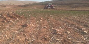
A group of colonists from the outpost Sidi Boaz, which is located on confiscated lands from the village of al-Khadr, on April 08, 2015 attempted at opening a agricultural road (4m width) on a 3 dunum plot belonging to a citizen from the village. Noteworthy, the incident took place at midnight in order for colonists not to be noticed. At the morning of next day, famers were surprised to find out that a colonial road was opened on their lands.
It should be marked that the reason behind opening such a road is to link it to another colonial road relative to the outpost. This serves the expansion of Sidi Boaz and the confiscation of more land for this very end.
Citizen Iyad , who works for al-Khadr municipality, told a researcher from Land Research Center the following:
“Opening a road in the middle of Palestinian agricultural roads is extremely dangerous for it gives colonists the pretext to take over more land to be annexed to their colonies and outposts”


Photos 1+2 : the opening of the new road in Wad al-Ghwait
Al Khadr:
Located 4 kilometer west of Bethlehem, Al Khadr village is surrounded by Beit Jala and Battir (north), Husan and Nahhalin (west), Ad Doha, Wadi Rahall, and Beit Jala (east), Wadi An Nais (south).
Al Khadr has a population of 9774 according to statistics conducted in 2007. It has a total area of 8279 dunums, 184 of which are built-up area.
The Israeli occupation confiscated 29 dunums of Al Khadr lands for Efrat and Daniel colonies. Efrat was built in 1979 and devoured 5.8 dunums of Al Khadr. It is inhabited by 7037 colonists. Daniel was built in 1982 and confiscated 23 dunums. 1073 colonists live in the colony.
Bypasses number 60 and 375 devoured more than 487 dunums. Not to mention the Apartheid Wall that destroyed 280 dunums and isolated 5638 dunums of the village. The Wall in Al Khadr is 2805 meters long.
According to Oslo Accords, 10% of Al Khadr is under Area A (PA has full civil and security control) while 6% is under Area B (PA is in charge of civil matters with Israel responsible for security). However, most of the village lands (84%) is under Area C (Israel maintains full security and administrative control). Here are the areas in dunums:
- Area A (808) dunums
- Area B (475) dunums
- Area C (6996) dunums

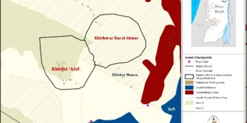
Map 1: the geographical location of al-Khadr and its lands classification according to Oslo Accords.
Prepared by
The Land Research Center
LRC