Violation: serving stop-work order on a road
Date: 03/03/2015
Location: Qaryut village/ Nablus
Perpetrators: Israeli occupation army
Victims: residents of the village
Details:
Qaryut village, south of Nablus city is considered a primary target for the Israeli occupation authorities and its expansion plans. The village accommodates four colonies that expand at the expense of Palestinian lands and damage the nature and environment of the area.
It is indicated that the village council of Qaryut embarked on rehabilitating a agricultural road in the southern part of the village with funds from First Aid Association and EU; the rehabilitation came for the sake of protecting lands from any futuristic colonial expansion plan, taking into account that the area is surrounded by a number of colonies namely (Shilo, Eli, Hewval .)
The rehabilitation project included three roads with an estimate of 190,000 INS as follows :
- Al-Sahlat road (1500m)
- Khirbet Sura road (1700m)
- Ein Qaryut road (300m)
It should be marked that the aforementioned roads are located to the south of the village; according to the data of the village council, the roads serve 1500 dunums, of which 700 dunum are planted with field crops where the rest are planted with olive and almond trees. Noteworthy, the lands are owned people from the village.

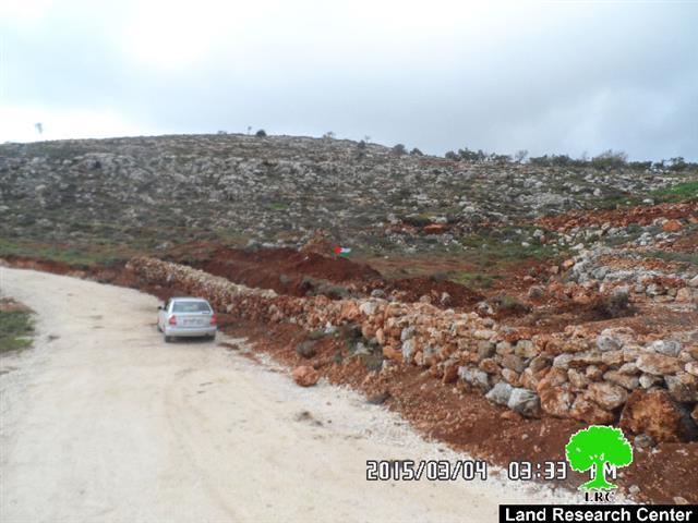
Photo 1: the military order of stop-work


Photos 2+3: the targeted road that overlooks Shilo colony
On March 03, 2015, the Israeli occupation authorities served Qaryut village council a stop-work order compelling a halt of construction on the aforementioned roads under the pretext of lacking legal permits and licenses in area classified C according to Oslo Accords.
The military order no. (181401) gave farmers a deadline until March 29, 2015 to complete all licensing procedures. This comes in time with the hearing session of Israel Planning Committee in the court of Beit El to consider the status of the notified structures.
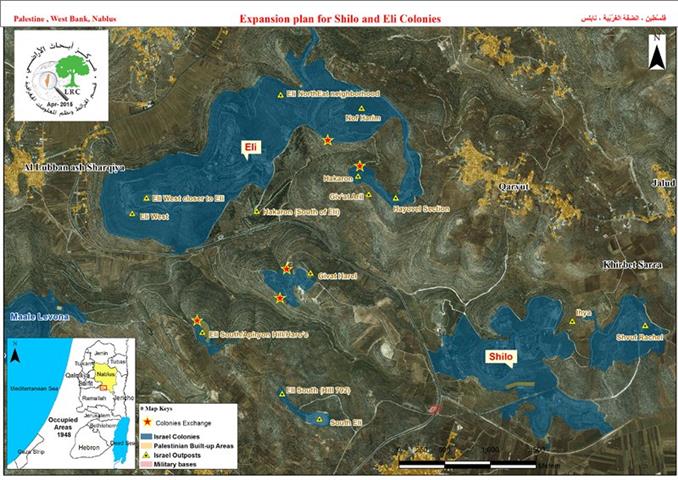
A plan to connect the colonies in Qaryut via a road network:
Recent documents and maps revealed that the Israeli occupation authorities intend to establish a road network to link (Eli, Shilo, Rahel, Hewval) colonies to each other. This is step towards confiscating more lands from Qaryut for the favor of the colonies.

Photo4: the proposed map for the road network
A member from Qaryut village council Bashar Qaryuti told a researcher from Land Research Center the following: "This plan will be a catastrophe on the residents; more than 1000 dunums that are located between those colonies will become subject for confiscation. In addition, the plan will ruin any chance to re-open the southern road of the village , which links it to the bypass road no.60; this is proved on the proposed map!".
He also added: " there is also another plan to pin down the Israeli presence in the area; this plan suggests opening a route for bicycles nearby the confiscated Khirbet of Silon. If implemented, a vast area from Qaryut lands will confiscated for the favor of this touristic plan."
It should be marked that the Israeli occupation never stopped harassing the people of Qaryut ever since 1967; a total of 80% from the village's lands was taken to serve a major colonial plan to separate the north of the West Bank from the south.
It should also be marked that that more than 15 residences are threatened with stop-work and demolition, not mentioning the olive groves that have been declared inaccessible for farmers. The Israeli occupation authorities continued carrying out raids and break- ins on houses and fields of the area, leaving many youth dead, injured or arrested.
Prepared by
The Land Research Center
LRC