Violation: a watchtower established in a school
Date: 01/08/214
Location: Burin/ Nablus governorate
Perpetrators: the army of the Israeli occupation
Victims: students of Burin High school
Details:
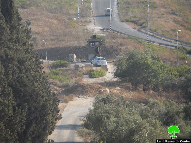
In synchronization with a new school year, the army of the occupation built a military watchtower on the lands of Burin High school from the southern parts. Noteworthy, the watchtower is only 150m away from the school.
According to the field follow-up of the tower, it is located by the bypass road no 60, overlooking the entrance of Yetzhar colony from the north.

Photo 1: the school and the watchtower
A previous plan of the watchtower:
It should be mentioned that the commander of the Israeli army in the West Bank has previously served a confiscation order no.14/3/C on 23/02/2014. The order included the takeover of 184m2 of Burin lands on the natural block no.8; in the location of Ziqaq Abu Omar behind the school. The pretext came under military purposes.


Photos 2-4: the military order of confiscation
For further information about the confiscation order, please read through ARIJ (Applied Research Institute- Jerusalem) report here
Imminent threat on the students:
Teacher Adli Qadus, about the watchtower threat on the students, to the LRC observer stated: “the act of building a watchtower in a school is provocative for students age between 13-18 and that is the age of impulsiveness. It is most likely for the soldiers to provoke the hot-blooded boys to justify their harassments. That would also give the occupation the chance to more violations against the residents of the town”.
The village of Burin is considered a devastated one sine it located amidst of several colonies as follows:
Bracha colony and Givat Yacoub outpost to the north
Yetzhar colony to the south and west
Huwara military camp to the east
Nahal military camp to the west
About Bourin:
8km to the west of Nablus city Bourin is located with a total land area of10,416 of which 335dunums is built-up area and a population of 3500people. There are two colonies located on the lands of Bourin namely ( Bracha colony , which confiscated 205 dunums from village, and Yitzhar colony, which confiscated 150 dunums form the village)
The LRC observation team followed up the Israeli violations against lands and housing in Burin during 2014. They came as follows:
- Yitzhar colonist damage 25 olive seedlings, 21/01/2014 (Ar, Eng)
- Deposit of master plan of Bracha colony, 06/07/2014(Ar, Eng)
- Expansion works on Bracha colony, 06/07/2014( Ar, Eng)
- Bracha colonists burn down olive trees in Irak Burin 11/07/2014 (Ar, Eng)
Prepared by
The Land Research Center
LRC