Contents
- Prelude,
- Israeli violations in the Occupied Palestinian Territory in 2013
- Israeli Military “Land Confiscation” orders in the year 2013
- The Israeli Segregation Wall
- Israeli Settlers’ Violence
- Israeli settlements’ Expansion in 2013
- Israeli Settlements and Roads Plans in the oPt during the year 2013.
- The Dilemma of Jordan Valley
2013 Sum-up
Prelude,
The Israeli officials’ statements on Jerusalem are blunter than usual; as a high ranking official from Jerusalem municipality profess that the Segregation Wall will mark the boundary of Jerusalem city and once the Wall is completed, which ever Palestinian neighborhood stands east of it will no longer be considered a Jerusalem neighborhood, and this concept applies on Palestinian Jerusalemites not living within the newly defined city boundary, they will lose their right to live in the city. On the other hand, the Israeli municipality of Jerusalem spared no efforts to consolidate the Israeli existence in occupied East Jerusalem and passed plans to build more illegal housing units in settlements in Jerusalem as the approval for the 1500 units in Ramat Shlomo settlement northeast of Jerusalem. The approval for the plans came through at the time the international community is exerting all kind of efforts to resume the peace process.
On January 22nd, 2013 Netanyahu pulls a narrow victory in a tight election but still was enough to make him the head of the 33rd Israeli government. He made it abundantly clear to devote his term to fortify the settlements and live up to his campaign slogan "a strong leader for a strong nation," and undermine the peace process. He pledged plans and tenders for 775 housing units in settlements that month.
The U.S Secretary of State John Kerry paves the way for a first visit in March to Israel for the U.S President Obama – the first since he took office back in 2008. the Israeli prime minister Netanyahu preferred to cut short any illusion anticipated from the upcoming visit and decided to slam dunk any hopes to recreates the Annapolis 2007 scenario and cease settlements construction for to resume negotiation and decided to show a preview of what to come; hence sanctioning plans and tenders for 408 housing units in settlements in February.
Upon the U.S President Obama visit to Israel and the Palestinian territory, Israel refrained from issuing announcements for plans and tenders in Israeli settlements. Netanyahu on his part laid out his thoughts on negotiations with the Palestinians and want them to concede:-
- Israel as a “Jewish” state
- Jerusalem is unified under Israeli rule forever
- Israel has a right to build everywhere in Ma’ale Adumim as in Tel Aviv
- The Jordan Valley under Israeli control
At the end of the U.S President Obama visit to Israel and the Palestinian territory, the U.S granted Israel U.S.D 3.4 billion in funds and military deals including jet fighters and high-tech missiles. … in counter action, the Israeli P.M Netanyahu approved plans and tenders for 220 housing units in settlements. Later in May, the Israeli P.M pushed plans and tenders and for 1447 housing units in settlements in response to U.S Secretary of State John Kerry attempt to revive the negotiations. In June, U.S Secretary of State John Kerry returned to the region for the fifth time since the beginning of 2013, and unsurprisingly, the Israeli municipality of Jerusalem announced construction of 69 housing units in Har Homa settlement. In fact Israel declared approvals for plans and tenders for 2977 housing units in settlements.
At the time the peace process witnessed a breakthrough in July, even though Israel sought to make it clear that it will not cease settlements’ construction under any circumstances; hence, Israeli authorities issued approvals for plans and tenders for 1573 housing units in settlements by the time the first round of negotiation started on July 31. At the second round of negotiations, on August 13, Israel issued approvals for plans and tenders for 2125 housing units in settlements undermining previously claimed confidence measures and inflicting detrimental damages to the negotiations process. In October, Israel announced tenders and plans of 6185 housing units in various settlements in the occupied Palestinian territory.
November was an exponential month for the settlement program and a true manifestation of the Israel’s intention toward the peace process and the negotiation process with the Palestinians as they issue an exponential number of housing units in Israeli settlements exceeding 24000 housing units. This announcement, which was made by the Israeli minister of housing and construction Uri Ariel, was quickly rebuffed by the Israeli Prime Minister Netanyahu. Nonetheless, this Israeli stunts has certainly played its part as a diversion to last month announcement especially since many of last months’ plans and tenders announcements were already in the process of setting up the infrastructure and others already under construction.
It seems that the Palestinians will be the ones who will pay for the Israeli wrath over the Iranian – western countries nuclear deal. On that notion, Israel announced hours following the affirmation of a deal to resolve the Iranian nuclear affair peacefully, plans and tenders for 1344 housing units in Israeli settlements in the occupied Palestinian territory.
However, Netanyahu the Israeli prime minister believed that the announcement of the construction plans should not hinder the efforts to launch the negotiation but the US and the EU had other views. On that, the European Union reacted firmly and decided to orchestrate boycott of the Israeli settlements and all what is related to it. The US secretary of State Kerry reflected on the Israeli announcements of the construction plans in a negative manner describing the Israeli approach toward the peace process. The Arab league has also expressed its discontent with the Israeli announcement saying that Palestinians will not engage in negotiation under such circumstances. Still, and in spite of the international restlessness of the Israeli attitude, the latter refused to reconsider its announcements of new housing units’ construction; and even more continued with its preparation plans announcing thousands of units ready for construction in Jerusalem and all over the West Bank.
Israeli violations in the Occupied Palestinian Territory in 2013
During the year 2013, the Israeli violation touched thequality of life ofmany Palestinians, and contributed to consolidate thehardships of life forcedupon them by the Israeli occupation in all of itsforms. Table 1 shows variousIsraeli violations during the year 2013. See Table 1
|
Type of Violation |
Confiscated Lands |
Uprooted Trees |
Demolished Houses |
Threatened Houses |
||||
|
Month/2013 |
West Bank |
Jerusalem |
West Bank |
Jerusalem |
West Bank |
Jerusalem |
West Bank |
Jerusalem |
|
January |
35 |
0 |
490 |
100 |
12 |
12 |
48 |
29 |
|
February |
297 |
191 |
289 |
660 |
4 |
8 |
52 |
51 |
|
March |
827 |
0 |
857 |
0 |
1 |
1 |
23 |
0 |
|
April |
573 |
0 |
1492 |
0 |
13 |
12 |
42 |
5 |
|
May |
5 |
0 |
3343 |
120 |
9 |
11 |
208 |
8 |
|
June |
532 |
5 |
1825 |
0 |
11 |
3 |
68 |
38 |
|
July |
5770 |
0 |
1620 |
0 |
2 |
2 |
13 |
2 |
|
August |
3 |
0 |
45 |
0 |
20 |
8 |
35 |
23 |
|
September |
550 |
0 |
400 |
0 |
64 |
13 |
60 |
39 |
|
October |
20 |
0 |
1426 |
0 |
3 |
16 |
68 |
28 |
|
November |
1482 |
0 |
350 |
0 |
8 |
9 |
58 |
20 |
|
December |
510 |
0 |
40 |
0 |
25 |
0 |
48 |
12 |
|
Total |
10604 |
196 |
12177 |
880 |
172 |
95 |
723 |
255 |
|
Grand Total |
10800 |
13057 |
267 |
978 |
||||
Source: The Urbanization Monitoring Department, ARIJ 2014
House Demolition
The long and extensive history of the ingoing Israeli house demolition policy in the occupied Palestinian territory does not only constitute a grave breach of Palestinian right to housing, but also an application of the prohibited "collective punishment" as emphasized in the Fourth Geneva Convention of 1949; Article 33, which strenuously rebut without exception; infliction of punishment on an individual/s for an act committed by another.
Art. 33. No protected person may be punished for an offence he or she has not personally committed. Collective penalties and likewise all measures of intimidation or of terrorism are prohibited.
In addition to article 33 of the Geneva Convention, Israel's house demolition policy in the occupied Palestinian territory was never based on military necessities as indicated in Article 53 of the Convention but merely on vindictive reasons as collective punishment and in Jerusalem; house demolition is carried out to clear Palestinian houses for the illegally built Israeli settlements.
Art. 53. Any destruction by the Occupying Power of real or personal property belonging individually or collectively to private persons, or to the State, or to other public authorities, or to social or cooperative organizations, is prohibited, except where such destruction is rendered absolutely necessary by military operations.
During the designated period of this report, the Israeli Army demolished 267 Palestinian houses in the West Bank territory, 95 of whichin Jerusalem city. Chart 1 shows the number ofPalestinian's housesdemolished in the West Bank and Jerusalem over thedesignated period of thisreport.
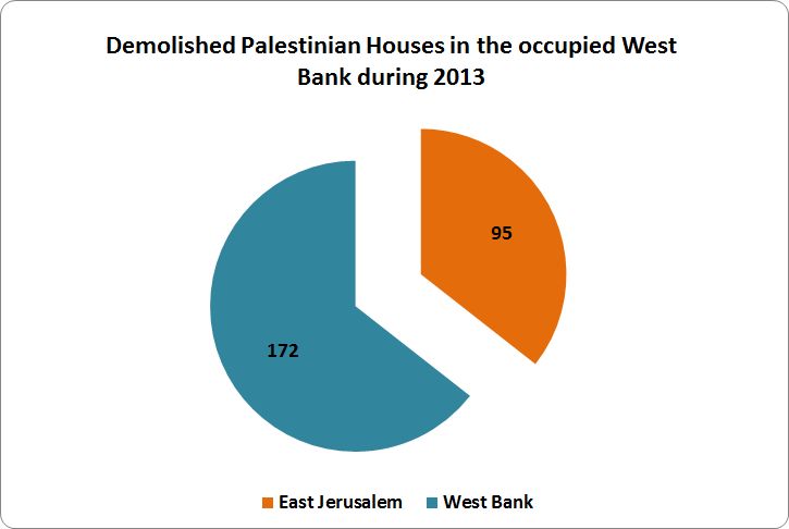
Chart 1: Demolished Palestinian Houses in occupied West Bank and East Jerusalem in 2013
Moreover, 939 Palestinian residences in the West Bank, including 255 in Jerusalem received demolishing orders during the year 2013.
Confiscation and Destruction of Agricultural Land
Like people and property, Palestinian agricultural and cultivated lands were always standing targets and witnesses of the Israeli occupation aggression against Palestinians. Lands destroyed and poisoned, trees uprooted are all patterns of Israeli Army and settlers' hostilities against anything Palestinians. Prior to the time when the Segregation Wall started back in 2002, Israel used to confiscate Palestinian's lands in the occupied West Bank territory to build and expand settlements or to construct and increase the bypass roads network.
However, with the construction of the Israeli Segregation Wall, the concept to continue confiscating Palestinian lands remained, even though; now the purpose of confiscation is far more grievous and goes beyond the tangible outcome, which is to build the Segregation Wall; as it adamant to capture 774 Km2 (13+%) of occupied West Bank area. During the year 2013, Israel confiscated or destroyed at least 10800 Dunums of Palestinian land in the West Bank.
|
|
Pie Chart 2: Confiscated Palestinian Land during the Year 2013
Uprooting of Palestinian Trees
Palestinian cultivated lands with fruitful trees have always been a favorite choice of the Israeli Army to build the Segregation Wall on or for any other related act. The reason why trees are systematically targeted by the Israeli Army is because for what the represent to Palestinians; a bond to their lands, their livelihood and a bona fide proof of their indisputable rights to the land. The Israeli Army uprooting Palestinian trees does not only coerce its will on the ground to build the Segregation Wall or build/ or expand settlements; but it destroy the reason for Palestinians to keep on hanging to their lands.
The Israeli Army systematic attack on Palestinian trees has started with the Israeli occupation of the Palestinian territory back in 1967 and resulted in the uprooting of more than 1000,000 until 2001. Since 2002, to date an additional 1.5 million trees were uprooted; in the Gaza Strip to establish security buffer zones and in the West Bank to build the Segregation Wall. In the year 2013, the Israeli Army uprooted 13057 trees.
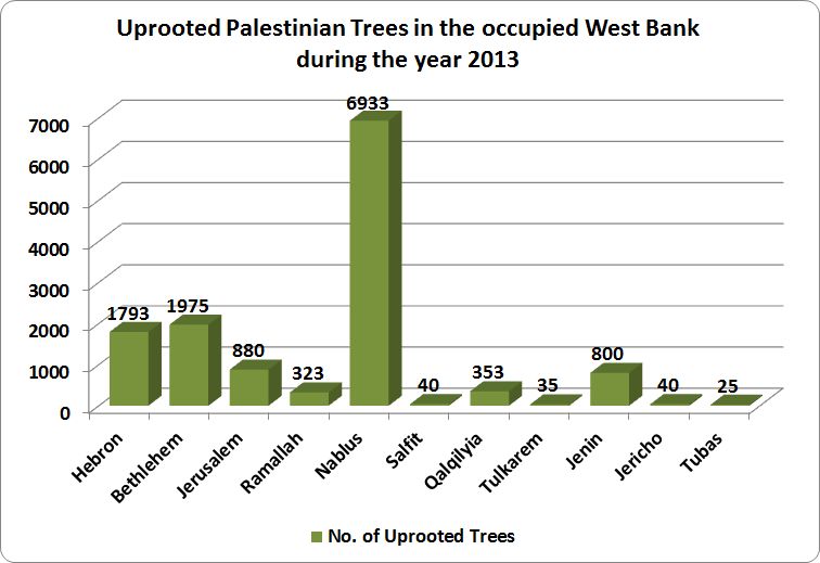
Pie Chart 3: Uprooted Palestinian Trees in the occupied West Bank during the Year 2013
Israeli Military “Land Confiscation” orders in the year 2013
Land confiscation policy based on security reasons and military needs is intended to furnish the Israeli settlers with territory they can build and live on; and eventually to transfer as much civilians as possible into the oPt. That’s how Israel looted the land, that’s how Palestinians have lost more than fifty percent of their land.
The following list “Land Confiscation” Israeli Military orders issued during 2013 in the oPt.
- On the 30th of January and 11th of February 2013, the Israeli Occupation Authorities issued two military orders to evacuate 19 dunums of Palestinian land in Husan village in Bethlehem governorate, under the pretext that the land is classified by the Israeli Authorities as “State land”. The first military order holds No. 2206 and confiscates 15 dunums of land, while the second military order holds No. 2207 and confiscates 4 dunums of land.
|
|
|

- On the 11th of February 2013, the Israeli Civil Administration handed over Palestinians of Khallet An-Nahla area in Bethlehem governorate, a military order No. “2169” to confiscate 7 dunums of land under the pretext that the targeted land is classified by the Israeli Authorities as “State land”.
 |
- On the 12th of February 2013, the Israeli Occupation Army handed over Palestinians of Nahhalin village in Bethlehem governorate 6 military orders to evacuate land in the village, under the pretext that the targeted lands are classified by the Israeli Authorities as “State land”. The first military order holds No. 2173 and confiscates 3 dunums of land; the second military order confiscates 1.1 dunums of land and hold No. 2176; the third military order confiscates 18.1 dunums of land and hold No. 2179; the fourth military order holds No. 2180 and confiscates 0.6 dunums of land; the fifth military order hold No. 2181 and confiscates 15.8 dunums of land; and finally, the sixth military order holds No. 13/04 and confiscates 6.2 dunums of land.
|
|
|
Military Order No. 2173 (17/3)
|
|
Israeli Military Order 2176
|
|
 |
|
|
|
|
|
- On the 3rd and 11th of March 2013, the Israeli Occupation Authorities handed over residents of Khallet Ad-Dab’a, east of Yatta town in Hebron governorate five military orders to seize 134 dunums of land. According to the orders, the Israeli Authorities claimed that the targeted lands are classified as “State land”. The first order which confiscates 35 dunums of land holds No 1066; while the second military order holds No. 1065 and confiscates 60 dunums of land. The third military order holds No. 1029 and seizes 4 dunums of land. The fourth military order, it confiscates 25 dunums of land and holds No. 1031 and the fifth military order holds No. 1030 and confiscates 10 dunums of land. On the 14th of March 2013, the Israeli Civil administration issued a military order to extend the validity of military order No. 34/03/T which confiscates 3 dunums of Palestinian land in Jalamah village in Jenin governorate to expand the area around Al-Jalamah terminal.
|
|
|
|
|
|
- On the 14th of March 2013, the Israeli Occupation Army handed over Palestinians of Az Zubeidat village in Jericho governorate two military orders holding No. 1036 and 1037 to evacuate 5 dunums of land and to uproot more than 70 palm trees.

- On the 29th of April 2013, the Israeli Occupation Authorities issued a military order No. “2085” to seize 2 dunums of Palestinian land planted with 50 trees in Wad Rahhal area in Bethlehem governorate, under the claim that the targeted land is classified as” State land”, by the Israeli Authorities.
- On the 12th of May 2013, the Israeli Occupation Authorities issued an order No. “13/08/T” to confiscate 3.5 dunums of Palestinian land in Tequ village in Bethlehem governorate, to construct a security fence around Tequ settlement from its northwestern side.
- On the 22nd of May 2013, the Israeli Occupation Army handed over Palestinians of Bruqin village in Salfit governorate two military orders to evacuate 23 dunums of land under the claim that the land is classified as ”State land”. The first military order holds No. 1131 and confiscates 9 dunums of land; while the second military order holds No. 1132 and confiscates 14 dunums of land.
|
|
|
- On the 3rd of June 2013, the Israeli Occupation Authorities issued a military order No. 13/03/T to confiscate 63.40 dunums of Palestinian land in Awarta, Rujeib and Beit Furik villages in Nablus governorate for security purposes. Maps attached to the military order showed that the Israeli Authorities intend to construct a security fence around the settlement of Itamar, in the northern West Bank.
-
- On the 17th of June 2013, the Israeli Occupation Authorities issued a military order No. 1002 to evacuate 14 dunums of land in Saffa village in Ramallah governorate. The Israeli Authorities claim that the targeted land, which is located few kilometers east of Mod’in Illit settlement bloc, is classified as “State land”.

- On the 26th of June 2013, the Israeli Occupation Army issued a military order No. 13/11/T to confiscate 3.55 dunums of Palestinian land in Kafr Qalil village in Qalqilyah governorate, in order to create a geographical link between the Israeli illegal outpost of Mitzpe Yousef and Bracha settlement.
- On the 10th of September 2013, the Israeli Occupation Authorities issued 6 military orders to seize 304 dunums of Palestinian land in Beit Nuba village in Hebron governorate, under the claim that the targeted lands are classified as “State land”. The orders come as follow: the first military order holds No. 1702 and seizes 90 dunums of land; the second order holds No. 1703 and confiscates 16 dunums of land; the third military order holds No. 1704 and confiscates 90 dunums of land; the fourth military order holds no. 1706 and seizes 8 dunums of land; the fifth military order holds No. 1707 and confiscates 30 dunums of land, and the last military order which holds No. 1708, confiscates 70 dunums of Palestinian land.

| |
|
| |
|
| |
|
- On the 15th of September 2013, the Israeli Civil Administration issued a military order No. 2160 to evacuate 3 dunums of Palestinian land in Al-Khader village in Bethlehem governorate, under the pretext that the targeted land is classified by the Israeli Authorities as” State Land”.
- On the 2nd of October 2013, the Israeli Occupation Authorities handed over Palestinians of Kafr Jammal and Falamiya villages in Qalqilyah governorate an extension of validity to military order No. 39/02/T. The order extends the confiscation of 78.3 dunums of land until the year 2016 to continue the construction of the Israeli segregation wall in the area. The order also includes an amendment to the wall section which is being implemented on lands of the aforementioned villages.
|
|
|
The Arabic and Hebrew versions of the Military Order
|
|
A copy of the Military Order issued in 2013
- On the 3rd of October 2013, the Israeli Occupation Army handed over Palestinians of Yatma and Qabalan villages in Nablus Governorate an extension of validity to military order No. 57/06/T to continue the confiscation of 3.8 dunums of land to construct a security fence along a section of the Israeli bypass road 505.
- On the 2nd of November 2013, the Israeli Occupation Army handed over Palestinians of Aqraba village in Nablus governorate an extension of Validity to military order No. 60/06/T to continue the confiscation of 5.3 dunums of land to construct a security wall along a section of the Israeli Bypass road No. 505.
- On the 22nd of December 2013, the Israeli Occupation Authorities issued a military order No. 13/07/T to confiscate 3.11 dunums of Palestinian land in Qusra village in Nablus governorate in order to construct a security fence around Esh Qodesh Israeli outpost.
The Israeli Segregation Wall
The status of the Segregation Wall has not witnessed any significant change to its status, however, the Israeli Army issued extensions on standing military orders for military use “for the Wall purpose” of which in Beit Jala, and Walajeh west of Bethlehem governorate, also in Bilin, in Ramallah, and at the far south side of Hebron governorate.
Currently, the Israeli Army is working on 55 km (7%) if the wall length (774 km), and has completed 64% (495 km) of it, while 224 (29%) is still in the planning phase. The significance of the Israeli Segregation Wall that snatch some 13% of the West Bank and redefines the boundaries of the city of Jerusalem, where Israel plan for the metropolitan Jerusalem area that will include three major settlements bloc; Giva’t Ze’ev in the north, Ma’ale Adumim in the east and Gush Etzion at the southwest side of Jerusalem. Upon completion, Jews will enjoy demographic favor to the Palestinian population.
Israeli Settlers’ Violence
In the same token of previous years, the Israeli continued with their normal proceedings in the occupied Palestinian territory (oPt). Settlers continued their obliteration against Palestinians and their properties; uprooting trees, snatch Palestinian houses; all under the protection of the Israeli Army.
The Israeli settlers attacks across the past decade in particular has definitely been upgraded from being violent attacks associated with severe hostility toward the Palestinian civilian population to an organized attacks orchestrated that terrorize and imperil the lives and way of life the Palestinian population. Spanning over 45+ years of occupation, the Israeli settlers have been nibbling away of the occupied territory to accommodate nearly 700 thousand settlers residing in 196 settlements and 234 outposts. Their existence and ever-growing numbers there has grounded any suspicious that the much debated two-state solution has been brought to a halt.
The Israeli settlers’ attacks on Palestinian and their properties in the occupied Palestinian territory remains to be a main concern especially that such attacks are disregarded by the Israeli occupation Army; in fact much of such attacks are carried out under their protection and direct sight. The settlers premeditated attacks has grown over the past decade in number of and also in types of attacks, which have grown more violently than even the Palestinians expected over years. The Israeli settlers stopped at nothing to turn the Palestinians lives upside down, destroying the agricultural lands, uprooting and burning trees, contamination of cultivated fields and wells. Statistics shows that settler violence against Palestinians and their property in the occupied Palestinian territory is on the rise. Since 2007 more than 2000 attacks were carried out by Israeli settlers including some 755 attacks carried out by Israeli settlers between January and December 2013. See Pie chart 4.
 |
Pie Chart 4: Number of Israeli settlers’ attacks by month
Even more; the attacks carried out by Israeli settlers included defacing religious sites including churches, mosques, burning and writing profound graffiti. it is without doubt that the Israeli settlers find their courage, support, and motivation to carry out their attacks on the Palestinians with the Israeli government and army as the latter spare no effort to protect them, in fact the Israeli army provide cover for their attacks, which are carried out throughout the West Bank governorate especially in Nablus, Jerusalem, Hebron and Bethlehem. See Chart 5.
 |
Chart 5: Israeli settlers’ attacks by governorates
The figures for the number of attacks reflects a worrying trend, particularly in recent years as such attacks are carried out under the “price tag” slogan, which is a reaction or retaliation on the Israeli settlers’ part against Palestinians for an act the Israeli army takes against settlers while supposedly “enforcing the law”. The Israeli attacks on Palestinians have varied in types and have perpetrated various forms against Palestinians. See following chart 6.
 |
Chart 6: Israeli settlers’ attacks by type
Israeli settlements’ Expansion in 2013
The expansion in Israeli settlements continued at a noticeable pace but with more attention as the expansions schemes declared by the Israeli government’s various points of occupation were made in a manner and timing intended to convoy Israel’s position in any negotiation on the settlements’ issue and its status under any final agreement with the Palestinian side. On such thought Israel issued construction and plans approvals for 11066 housing units in 36 Israeli settlements (see Table 2) in 8 Palestinian governorates during 2013, most of which –7957 housing units (72%) in settlements located west of the segregation wall in the area that Israel declared repeatedly it is planning to annex to its proper under any agreement with the Palestinians (the area that falls between the Segregation Wall and the1949 Armistice Line). See Table 2
|
Table 2: Construction & Plans in Israeli Settlements during (Jan – Dec) 2013 |
||
|
# |
Settlement Name |
2013 |
|
1 |
Adam |
80 |
|
2 |
Alei Zahav |
1144 |
|
3 |
Alfei Menashe |
15 |
|
4 |
Almog |
31 |
|
5 |
Alon Shevut |
60 |
|
6 |
Ariel |
135 |
|
7 |
Beit El |
326 |
|
8 |
Betar Illit |
322 |
|
9 |
Bracha |
90 |
|
10 |
Bruchin |
550 |
|
11 |
Carmel |
97 |
|
12 |
Efrat |
155 |
|
13 |
El Matan |
37 |
|
14 |
Elkana |
284 |
|
15 |
Gilgal |
234 |
|
16 |
Gilo |
891 |
|
17 |
Giv'at Ze'ev |
131 |
|
18 |
Har Homa |
210 |
|
19 |
Itamar |
675 |
|
20 |
Karnei Shomron |
218 |
|
21 |
Kfar Adumim |
329 |
|
22 |
Kiryat Netafim |
19 |
|
23 |
Kochav Yaacov |
38 |
|
24 |
Maale Adumim |
204 |
|
25 |
Maon |
230 |
|
26 |
Modi'in Illit |
992 |
|
27 |
Nokdim |
40 |
|
28 |
Pisgat Zeev |
183 |
|
29 |
Ramat Shlomo |
1918 |
|
30 |
Rotem |
170 |
|
31 |
Sensana |
325 |
|
32 |
Shilo |
142 |
|
33 |
Talmon |
559 |
|
34 |
Tekoa |
24 |
|
35 |
Tene |
48 |
|
36 |
Yakir |
160 |
|
|
TOTAL |
11066 |
Source: The geo-Informatics Department, ARIJ 2014
Furthermore, the bulk of the housing units are within settlements blocks enfolding Jerusalem – within what is called by Israel the “Greater Jerusalem” area. Accordingly, much of the housing units were in settlements in Jerusalem governorate (3984 units–36%), followed by Salfit (2382 units—21.5%). The following Table 3 identifies the housing units and sorts its location according to which side of the wall: See Table 3
|
Table 3: Housing units in Israeli Settlements –2013 — According to Palestinian Governorate |
||||||||
|
Housing units |
Total |
percentage |
|
Of which |
percentage |
|
Of which |
percentage |
|
in 2013 |
West of |
East of |
||||||
|
|
the Wall |
the Wall |
||||||
|
West Bank |
11066 |
100% |
7957 |
72% |
3109 |
28% |
||
|
Jerusalem |
3984 |
36 |
3866 |
97% |
118 |
3% |
||
|
Salfit |
2382 |
21.5 |
2292 |
96.20% |
90 |
3.80% |
||
|
Ramallah |
1877 |
17 |
992 |
53% |
885 |
47% |
||
|
Bethlehem |
601 |
5.4 |
537 |
90% |
64 |
10% |
||
|
Qalqilyia |
270 |
2.4 |
270 |
100% |
0 |
0% |
||
|
Hebron |
700 |
6.3 |
0 |
0 |
700 |
100% |
||
|
Nablus |
817 |
7.4 |
0 |
0 |
817 |
100% |
||
|
Jericho |
265 |
2.4 |
0 |
0 |
265 |
100% |
||
|
Tubas |
170 |
1.5 |
0 |
0 |
170 |
100% |
||
Source: The geo-Informatics Department, ARIJ 2014
In addition to what is obvious regarding the significant under-development, and under-planning in Israeli settlements located east of the wall, the actual plans the do actually gets implemented are very limited and not in full scale. See chart 7.
|
|

Pie Chart 7: Settlements expansion area according to its location to the Segregation Wall
Moreover, based on an average housing unit size of 125 meters square, an additional area amounted to 1,372 million square meters was added to the settlements’ area, the bulk of which has taken place in settlements located in the western segregation zone (the area that falls between the Segregation Wall and the the1949 Armistice Line).
Israeli Settlements and Roads Plans in the oPt during the year 2013.
During the period from 2000 to 2012, Israel intensified the construction of settlements from 167.5 km square to 195.3 km square respectively, an increase by 17%. ARIJ's analysis has shown notable increase in the areas of the settlements but mainly in the vertical scale and not much horizontal, so while a settlement may show modest increase in area, it does not necessarily reflect the true nature as the increase is exemplified in the vertical limits and this is particularly seen in settlements blocks and occupied Jerusalem settlements. The following Table 4 only exhibits some selected settlements on this regard: See Table 4
|
Table 4: Expansion in selected Israeli settlements in the occupied Palestinian territory |
||||
|
Settlement Name |
Area/ Dunums (2000) |
Area/ Dunums (2012) |
Percentage of Expansion (2000 & 2012) |
2013 Expansion in sq meter |
|
Alei Zahav |
279 |
561 |
101 |
141856 |
|
Alfei Menashe |
1930 |
2825 |
46 |
1860 |
|
Alon Shevut |
720 |
1006 |
40 |
7440 |
|
Ariel |
4409 |
5143 |
17 |
16740 |
|
Beit El |
953 |
1113 |
17 |
40424 |
|
Betar Illit |
4286 |
4700 |
10 |
39928 |
|
Efrat |
1911 |
2283 |
19 |
19220 |
|
Giv'at Ze'ev |
2503 |
2998 |
20 |
16244 |
|
Har Homa |
786 |
2301 |
193 |
26040 |
|
Maale Adumim |
5542 |
7945 |
43 |
25296 |
|
Modi'in Illit |
2920 |
3653 |
25 |
123008 |
|
Pisgat Zeev |
1486 |
1607 |
8 |
22692 |
|
Ramat Shlomo |
1552 |
1626 |
5 |
237832 |
|
Total |
718580 |
|||
Source: The Geo-Informatics Department, ARIJ 2014
The following list in summary distinguish selection of the Israeli settlements and roads plans in the oPt in the year 2013
1- Israeli Bypass Road No. 20
In January 2013, Israel commenced the construction of a new bypass road on lands of Shu’fat and Beit Hanina communities north of Jerusalem city, Bypass Road No. 20: The new bypassroad aims at linking the northern illegal Jerusalem settlements with each other and regulating access of the future Israeli settlements and neighborhoods that are planned to be built in the city of Jerusalem.
The route of the Israeli bypass road will first connect with the Israeli bypass road No.9, known to the Israeli as 'Yigal Yadin Boulevard', passing by the settlement of Ramat Shlomo (Reches Shu'fat) from the east, and travels northwards, penetrating through the lands of Shu'fat town and continues along its northern slopes towards Beit Hanina town where it intersects at some point with the newly constructed bypass road No. 20. The road continues northwards, cutting through the lands of Beit Hanina and heads towards its last connection point with Bir Nabala Road (known to the Israeli as Beit Horon Road), where it finally connects with the Atarot Industrial Zone (An Israeli Industrial Zone). Plans for the Israeli bypass road No.21 were advanced in 2002 when Moriah Jerusalem Development Company, approved designs and published tenders for its constructions. The total budget of constructing the Israeli bypass road No. 21 is NIS 112 million and is to be completed by January 2015. The Israeli Ministry of Transportation claims that the main aim of constructing this new Bypass road is to reduce traffic congestion during rush hours in Jerusalem city by providing Israeli settlers living in Jerusalem settlements an alternative road for that purpose. See Map 1
|
Map 1: The plan of Israeli Bypass Road No. 20
2- Plans at Ma’manallh Cemetery:
In January 2013, the Israeli Municipality of Jerusalem announced about a plan to implement a project that combines recreation and business in Ma’mannalh cemetery (known to the Israelis as Mammilla cemetery). The municipality started planning an alternative plan in place, which has already been budgeted by the Israeli Finance Committee in the municipality, and allows the rezoning of land for the construction of the hotel as well as businesses and real estate projects. The Israeli plan at Ma’manallah cemetery is part of larger Israeli plan that targets Jerusalem old city with a set of National and Talmudic parks.
3- Permits issued for 90 new Israeli settlement units in the Giv’at HaUlpana outpost, near Beit Settlement
In February 2013, the late Israeli Defense Minister, Ehud Barak, approved the construction of 90 settlement units in the illegal settlement of Beit Il to the north of Ramallah Governorate. The newly announced settlement units are part of an overall plan for building 300 settlement units in the aforementioned settlement (Beit El) which the Israeli Government promised last year (in June 2012) to build for Israeli settlers of Giv'at HaUlpana settlement outpost. Additionally, this plan is being implemented by the Israeli Civil Administration as part of a compensation plan for the evacuation of the illegal outpost Giv'at HaUlpana which was declared eight months ago (in 2012) by the Israeli Prime MInister, Benjamin Netanyahu. The Giv'at HaUlpana outpost was classified as illegal by the Israeli High court of Justice, based on a ruling that the 30 housing units (5 Buildings) comprising the outpost were built on privately owned Palestinian lands of Ein Yabroud village in Ramallah Governorate. Moreover, the Giv'at HaUlpana outpost was among the outposts considered illegal according to 'Sasson' report of 2005 and accordingly must be dismantled. Sasson said in her report, 'there is no legal difference between the 71 outposts that went up before March 2001 and the 24 established after that date. They are all illegal. It is important to emphasize that it's not merely to evacuate the outposts but to cease the entire procedure of budgeting and transferring state funds to the outposts. The very heart of the report is about the enforcement of the law, which is not a political issue, but a legal one, of tremendous importance for a democratic state.' On the ground, the Israeli Government attempts to reconstruct and relocate the aforementioned outpost (Giv'at HaUlpana) inside the illegal Israeli settlement of 'Beit Il', to become part of it, by giving the green light for the first 90 settlement units (out of the total plan – 300 units) , which is just another malicious policy by the Israeli occupation in order to manipulate and circumvent the international community by legitimizing the illegal outpost (Giv'at HaUlpana) through annexing it to its 'Mother' settlement Beit Il, which is also Illegal according to Internal laws and Human Conventions. See Map 2
|
|
Map 2: Beit El settlement and Givat HaUlpana outpost
4- Israel Captures More than 40% from Palestinian Lands Using Twisted Methods, (The case of Absentee Property in east Jerusalem)
On March 28, 2013, the daily Israeli newspaper “Haaretz” revealed in a report published on its website that the so-called “Israeli Civil Administration” has allocated 37% of the total West Bank area to Israeli settlements, while less than 1% , specifically 0.7%, were allocated for Palestinians, as these lands were classified according to the Israeli interpretation of the law as “State Lands”. An analysis conducted by the Applied Research Institute – Jerusalem (ARIJ) showed that the Israeli divisions to what it calls “State Land” are as follows: 634,920 dunums (11.2% of the total West Bank area) are classified as “registered State Land”, where according to the Israeli equivocal interpretation of the laws, Israel consider itself the legitimate heir of the Jordanian State after its military occupation of the Palestinian lands in June 1967 which is absolutely erroneous. The second Israeli classification is the “declared State Land” with an area of 843,922 dunums (14.9% from the total West Bank area) declared as “state land” after the year 1979; while the third type is what Israel calls “surveyed State Land” which constitutes 11.7% of the West Bank with a total area of 666,327 dunums where the total area of lands classified by Israel as “State Land” is 2,145,169 dunums (37.8% from the West Bank area).
Note that 248,904 dunums (5% of the West Bank area) of the total state land area is located in area “A” and “B” according to Oslo II Interim Agreement signed between Israel and the Palestinian Liberation of Palestine (PLO) in 1995, where the great part of these lands is located in Hebron Governorate in the southern part of the West Bank. See Map 3
Map 3: The classification of the Israeli classified 'State Land'
5- "At a cost of USD 1.1 Billion": Israel takes over 234 Dunums of Lands of Beit Safafa and Sharafat to construct the Israeli bypass road No. 50.
The Israeli 'Moriah Jerusalem Development Company' along with the Israeli Municipality of Jerusalem and the Israeli Ministry of Transportation are currently advancing work in the Israeli bypass road No. 50, which penetrates deep inside the 1967 borders, on lands of Beit Safafa and Sharafat lands, south of Jerusalem. The road, as planned, will cause the destruction and confiscation of 234 dunums of lands of the aforementioned Palestinian communities and will complete the Israeli road network in the southern part of the city of Jerusalem. The Israeli Bypass road No. 50, extends from Golomb intersection inside the 1948 lands and heads south towards Sport Beitar Agodat, passing by Teddy Stadium and the Railway station in Al Malha town inside the 1948 lands. The road continues to extend southwards to Al Malha Shopping Mall to connect with Road No. 39 (Yetzhaq Modia Road), which is the last connection point inside the 1948 lands. From this point (Road 39), the road extends towards the south, penetrating deep inside the lands of Beit Safafa and Sharafat south of Jerusalem city, inside the 1967 borders and heads towards the illegal Israeli settlement of Gilo, to finally connect with the Israeli Bypass Road No. 60 which is the main connection point between Israeli settlements in the South of Jerusalem (Bethlehem and Hebron Governorates) and those in the north and inside the 1948 Lands. The Israeli Municipality of Jerusalem claims that the main goal behind constructing the Bypass Road No. 50 is to ease and improve the flow of Traffic in the southern outskirts of Jerusalem while the truth is that the road will mainly benefit Israeli settlers living in Israeli settlements south of Jerusalem, in the Gush Etzion settlement Bloc. in Bethlehem Governorate and the Israeli settlements in Hebron Governorate who will be able to drive to Jerusalem and to areas inside the 1948 Lands without having to stop at any single traffic light. The overall budget of constructing the Israeli Bypass road No. 50 is USD 1.1 Billion and is to be completed by the end of May 2015. See Map 4
Map 4: Road 50 plan in Beit Safafa and Sharafat south of Jerusalem city
6- Israel Retroactively legalizes four Israeli outposts in occupied West Bank:
In May 2013, the Israeli Civil Administration (ICA) has been instructed to begin a process of retroactively legalizing four Israeli outposts established on privately owned Palestinian land for which a demolition order was issued in 2003 by the Israel Defense Forces, GOC Central Command. The four outposts in question are Ma'ale Rehavam, Haroeh, Givat Assaf, and Mitzpe Lachish. The Ma’ale Rehavam outpost is located east of Bethlehem city. According to the ICA, Some of the houses comprising the previously mentioned outpost are built on land classified by Israel as state land while the remaining houses are located in Private Palestinian land. While Haroeh outpost, IS located north of Ramallah, was built on land with mixed status (state land and private Palestinian lands. The Givat Assaf outpost, located East of Ramallah city, the outpost is built on land that Israel classifies as private Palestinian land. And finally, the Mitzpe Lachish outpost, located southwest of Hebron city, the outpost is fully located on land classified by Israel as state land. See Map 5
Map 5: the location of the four targeted outposts in the occupied West Bank
7- Expansion at Sde Boaz outpost in Bethlehem Governorate:
On May 30, 2013, the Israeli settlers of “Nevi Daniel North” or known by the Israelis as “Sede Bo’az” outpost located in Wadi Al-Qassis area west of Al-Khader village, installed four new caravans (mobile homes) on a hilltop adjacent to the outpost. The Outpost of Nevi Daniel North or Sede Bo’azwas established in January 2002 when Israeli settlers from the illegal Israeli settlement of Nevi Daniel took over a nearby hill located about 1500 meters north of the settlement where the Illegal Israeli settlement of Nevi Daniel. The outpost started out with one Israeli settler who coarsely set-up a mobile “caravan” house in the area where he encircled the location with barbwires and attack dogs for protection. The settler who received help and protection from the Israeli Army while setting up the location of the outposts advocated for years for many other settlers to join him and live in the site of the outpost. And since its establishment, the outpost was subjected to expansion many times, where it got bigger in size with 16 caravans in the site inhabited about 20 Israeli settlers, who enjoy basic services and good infrastructure (water, electricity, roads), all come with the courtesy of the Israeli authorities in spite the fact that the outpost is illegal.
|
Figure 1: A closer view of Sde Boaz Outpost in Bethlehem Governorate
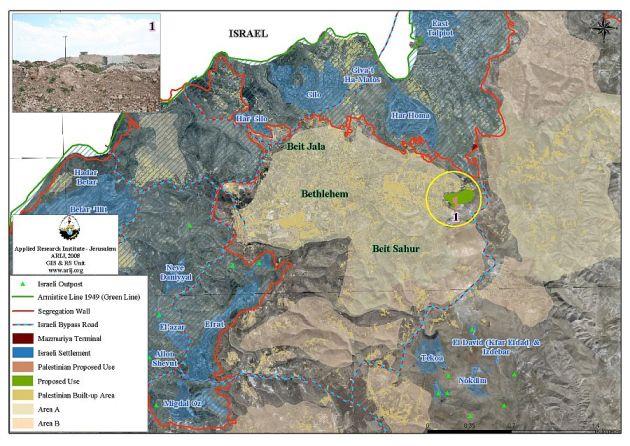
Map 6: The Sde Boaz outpost within the Gush Etzion Settlement Bloc.
8- Including areas “A” and “B”, Israel grants settlements’ councils control over more Palestinian land in the occupied West Bank
A report published by the Israeli daily newspaper (Haaretz) on the 27th of May 2013 indicates that the Israeli settlements jurisdiction area in the occupied West Bank increased by 7375 dunums (7.4 km²) in the year 2012 to stand at 538,303 dunums (538.3 km²) by the end of 2012 after it was 530,931 dunums (531 km²). A depth analysis prepared by the Applied Research Institute – Jerusalem (ARIJ) showed that the Israeli settlements jurisdiction area exceeds that of the Israeli settlements master plan area of 1991 which stood at 486.137 dunums of land (486.1 km², 8.6% of the total area of the WB), and is seven times the size of Israeli settlements area existed until the year 1991 which stood at 69,000 dunums (69 km², 1.2% of the total area of the WB) of land.
Haaretz also reported that the increase in settlements jurisdiction area is as a result of Israeli military orders that have been issued and ratified during the year 2012 and granted Israeli settlements’ councils in the West Bank control over new Palestinian land for settlement expansion, that is in addition to the area occupied by existing Israeli settlements and the area that comes under the Israeli settlements master plans. In fact, this increase has not been limited to the year 2012, because during the years of 1991 and 2011, the Israeli occupation authorities issued hundreds of military orders, which have not been made public, to confiscate more Palestinian land for security purposes and other flimsy pretexts.
These orders increased the Israeli settlements jurisdiction area to 530931 dunums (531 km²) by the end of the year 2011, an increase of 44,794 dunums (44.8 km2) of the Israeli settlements’ master plan area of 1991 (486.137 dunums (486.1 km²). Additionally, the Palestinian land that was confiscated through military orders to become part of the Israeli settlements jurisdiction area showed that 1.19% of the total settlements jurisdiction area falls within the area classified as "A" according to the Oslo II accords of 1995; the analysis also showed that 1.86% of the total settlements jurisdiction area falls within the area classified as "B" according to OSLO II accords of 1995; while the remaining area, which constitutes 90.8% of the total settlements jurisdiction area is located in the area classified as "C", including those classified by Israel as "State land" , closed military areas, mined areas and “Nature Reserves”.
|
Map 7: the Israeli settlements jurisdiction area in the occupied West Bank
09- The re-classification of Nahal Shilo Nature Reserve for the favor of Beit Arye settlement:
On the 27th of June, 2013, the Israeli Daily Newspaper (Haaretz) published on its Hebrew website that the improper conduct of the head of the Israeli Civil Administration, Motti Almoz, enabled the expansion of Beit Arye settlement west of Ramallah at the expanse of a nearby nature reserve, Nahal Shilo. This statement was confirmed by the Israeli Supreme Court in its response to a petition filed to the court by Israeli settlers of Beit Arye settlement regarding this matter.
The expansion plan of Beit Arye settlement was first promoted in late 90’s but it was until the year 2000 that the expansion plan was first approved. The plan didn’t go into the implementation phase because it had to go through some modifications throughout the previous years and was finally approved by the Israeli Civil administration in 2012. According to the approved plan, the borders of the of nature reserve, Nahal Shilo, didn’t match with the actual border of the Nature reserve, the thing that led to the ratification of a number of new housing units inside the borders of the nature Reserve, the thing that created a conflict between Israeli settlers of Beit Arye settlement and the Israeli Civil Administration.
|
Map 8: The Nahal Shilo Nature Reserve and Beit Arye settlement
10- The Refaim Park on lands of Al Walajeh and Battir villages
In July 2013, the Israeli District Planning and Building Committee related to the Israeli Ministry of Interior approved the town plan scheme No. 12222 to build “Refaim Metropolitan Park” in the southern parts of the city of Jerusalem. According to the plan that was developed by the Israeli Municipality of Jerusalem and the so-called “Israeli Development Authority”, Refaim Valley Park will occupy an area of 5,700 dunums, of which, 1850 dunums beyond the Green Line (Armistice Line of 1949), on lands belonging to Al Walajeh village (1200 dunums) and the nearby village of Battir. Note that Refaim Park is part of three large metropolitan “parks and green areas” being developed by the Israeli Municipality of Jerusalem and the Jerusalem Development Authority in Jerusalem city. Two of these parks, Arazim and Motza, are entirely within the Green Line in the western parts of the city Jerusalem. The overall budget of constructing the Refaim park is NIS 250 million, and is funded by the Israeli Municipality of Jerusalem, Israeli Prime Minister’s Office, Jerusalem Development Authority, and Ministry of Environmental Protection.
|
Map 10: The Refaim Park plan on lands of Al Walajeh and Battir villages
11- Two New Israeli neighborhoods are being promoted in Jerusalem and Hebron Governorates:
On the 8th of July 2013, the Israeli Hebrew website “Walla” revealed about two new settlement neighborhoods to be built in Jerusalem and Hebron Governorates. The first neighborhood is designed to expand Kfar Adumim settlement, northeast of Jerusalem city, by adding 255 new housing units to the site. The Kafr Adumim settlement is one among 9 settlements comprising the Ma’ale Adumim settlement bloc east of Jerusalem and which Israel plans to annex to its unilateral and illegal borders through the construction of the Israeli Segregation Wall. While the second neighborhood, will be built in the settlement of Ma’on, in the southern Hebron hills, and includes the construction of 230 new housing units. The “Walla” Hebrew website added that the Israeli Civil Administration will, in the next few weeks (from the issuance date of the plans), submit these plans for Public review (Palestinians and Israelis) to submit their objections against the plan. This is the last step before approving the settlement plan, after which, building permits and tenders may be issued at any time. Note that the expansion of Kfar Adumim settlement aims at housing 120 new Israeli families in the settlement, in addition to establishing public buildings, organizations, commercial areas and a road network.
12- A new Settlement at Bab As Sahera area in Jerusalem old city
On July 31st, 2013, the Israeli Ministry of Housing and Construction announced about a plan to build in a new neighborhood on 5-dunums land inside the old city of Jerusalem, near Bab As Sahera (Herod’s Gate). The new neighborhood will include the building of four new buildings (21 housing units) that is in addition to a synagogue and public buildings for the use of Israeli settlers who will live in the new neighborhood. The new neighborhood, if implemented, will replace the existing structures in the site.
13- An Israeli railway in the occupied West Bank:
In July 2013: The Israeli Civil Administration decided to go ahead with its railway plan for the West Bank and open it up for public objections, ignoring political borders. The plan includes the construction of 473 kilometers of rail with 30 stations on 11 lines and dozens of bridges and tunnels which are meant to connect all West Bank cities with one another; and the West Bank with Jordan and Syria. Note that in February 2012, the “Haaretz” daily newspaper published about the plan for the first time. According to the newspaper, the plan is prepared by the Israel’s Railways company upon the request of the Israeli Transportation Minister “Yisrael Katz”. The axes of the railway as follows: (1) The first one called “Daher Al-Jabal” which links Jenin Nablus, Ramallah, Jerusalem, Ma’aleh Adumim settlement, Bethlehem, Hebron, (2) The second axes is called the “Jordan Valley”, extends along the Jordanian borders and links Jericho, Dead Sea, Bisan, Ilat, and from Ilat to Haifa and then Syria in the future, (3) Nablus – Tulkarim axes, (4) Ramallah- Allenby Crossing Border axes, (5) Jerusalem Tel Aviv axes.(6) Jerusalem- Lod (Al-Lid) inside the Green Line, (7) Jerusalem – Ramallah (starting from Jerusalem and wrapping around Ramallah and linked with the central railway station), (8) Kiryat Gan inside the Green Line – Hebron and (9) Hebron – Beersheba inside the Green Line.
Clearly and without doubt, the proposed Israeli railway that Israel is preparing and pushing for, serves the interest of the Israeli prolonged occupation of the Palestinian Territory, with the aim to ensure a long-term control over the West Bank in addition to eliminate any chance to reach a just and lasting peace agreement with the Palestinians based on “Two State Solution” where an independent, contiguous, Palestinian Territory constitute the main elements of that solution. Even more, Israel wants to make sure that its existence in the West Bank becomes an integrated reality and inseparable from the Palestinians, hence the concentration on infrastructure that links all life elements of Palestinians and Israelis together.
|
Map 11: The railway plan in the occupied West Bank
14- A new Israeli Settlement in Salfit Governorate:
In August 2013, the Israeli daily newspaper, Maariv, reported that the Israeli Minister of Housing and Construction inaugurated a new neighborhood called Leshem, as part of the existing Alei Zahav settlement in Salfit Governorate. The neighborhood is being built on occupied Palestinian lands owned by Deir Ballut and Kafr Ad Dik villagers. According to Maariv, 72 Jewish families have already moved to live in their homes in Leshem neighborhood, and 70 more Jewish families are expected to move and live in the new neighborhood during the year 2014. In total, the plan includes the construction of around 400 housing units.
15- A National Park at Ir David settlement:
In August, 2013, the Israeli government and the Jerusalem municipality are to invest NIS 16 million in developing a national park at Ir David settlement (the City of David), illegally established on lands of Silwan town in Jerusalem city. The project includes the building a “functional model,” at an estimated cost of NIS 4 million, as well as a “video exhibit,” to cost NIS 9 million, and an “exhibition tunnel,” with a NIS 7 million cost. Half of the project’s cost would come from the Israeli Prime Minister’s office’s fund for national heritage sites. NIS 5 million will come from the Israeli Tourism Ministry, and the Israeli Jerusalem municipality is slated to add NIS 1.4 million. The rest of the funds, around NIS 3.6 million, will come from private Jewish donors.
16- Construction of Phase III of Nof Zion Settlement:
In August 2013, The Israeli Housing and Construction Minister, Uri Ariel, celebrated the cornerstone-laying ceremony of a new neighborhood on lands of Jabal Mukkabir town in East Jerusalem. The neighborhood is planned to include 63 housing units that will be constructed in the area between Jabal Al Mukkabir town and East Telpiot settlement (Armon Hanatziv). Bemuna company is building the neighborhood, which will be marketed to the religious public.
|
Map 12: location of Nof Zion settlement in occupied East Jerusalem
17- Two new Israeli neighborhoods in Karnei Shomron and Kedumim settlement in Qalqilyia Governorate
In August 2013, the Israeli Housing and Construction Minister, Uri Ariel, took part in a ceremony marking the start of construction of Ganey Shemer, a new neighborhood of 96 units in the Karnei Shomron settlement in Qalqilyia Governorate, as part of "Karnei Shomron 2020" program to turn Karnei Shomron and surrounding settlements into another “settlement bloc. The Israeli Minister also celebrated the corner-stone laying of a new neighborhood, of 160 units, in the Kedumim settlement in Salfit Governorate.
18- NIS 400,000 worth of infrastructure work to Negohot settlement
In August 2013, the World Zionist Organization’s Settlement Division has financed NIS 400,000 worth of infrastructure work in the West Bank settlement of Negohot in Hebron Governorate, even though the work was carried out without building permits over the past two years. The Israeli settlement of Negohot is located to the southwest of Hebron city and was establishment in the year 1982. The settlement covers an area of 227 dunums and had a population of 266 Israeli settlers in the year 2011. During the years 2002 & 2003, two outposts under the name of Mitzpe Lachish and Mirshalem were built on two hills northwest of Negohot settlement to house a population of around 70 Jewish settlers.
|
|
|
Map 13: Negohot settlement and its surrounding outposts, Mitzpe Lachish and Mirshalem
19- A national park on lands of At Tur and Al Issawiya towns, in occupied east Jerusalem
In August 2013, the Israeli occupation bulldozers flattened 20 dunums of land in At Tur and Al Isawiya towns, in east Jerusalem for the establishment of a national park on lands of the two aforementioned communities. Note that on April 4, 2011, the “District Planning and Building Committee” of the Israeli Ministry of Interior approved a Town Plan Scheme No. 11092A to turn 662 dunums of lands from Al Isawiya and At Tur communities’ lands into a National Park. The objective of the Plan is (1) to connect the area with the "Holy Basin, (2), to eliminate Palestinian urban development: offering no housing plan in response to the needs of the growing Palestinian population in the future, (3) the 2020 Jerusalem Master Plan: “the city's population must have a Jewish majority and Palestinian minority”, (4) the plan marks the eastern Gate of Jerusalem, (5) the "National Park" will connect the Hebrew University settlement in the west of Jerusalem city with the main road leading to Ma'ale Adumim Settlement in the east and At-Tur neighborhood (Mount of Olives in the south to Al 'Isawiya in the north.), and (6) the National park Plan No. 11092 is a small part of a large-scale Israeli National Parks Plan to construct nine national parks in the hills of Jerusalem and around the municipal borders.
|
Map 14: Location of Plan No. 11092 A
20- Dead Sea- Gush Etzion Road Project:
In September 2013, the Israeli Maariv daily newspaper reported on its Hebrew website that Israel has recently approved a plan to construct a new bypass road that will extend from the Gush Etzion settlement bloc to the Dead Sea area, east of Bethlehem. The new Israeli bypass road is intended to be the longest road connecting illegal Israeli settlements located in the southern West Bank (Bethlehem and Hebron) to the Dead Sea area and with Israeli settlements inside Israel. The project is estimated to cost $34 million and will, according to Maariv, reduce the time between Gush Etzion settlement bloc and the Dead Sea area to around 30 minutes. Work on the road is expected to start in January 2014.
|
Map 15: TheDead Sea- Gush Etzion Road Project
21- Israel to expand the Jerusalem light rail route
The Israeli daily newspaper, Haaretz, reported in September 2013, that the Jerusalem Municipality is adding new stops to the Jerusalem light rail to increase the number of travelers to 250,000 a day, up from the current 140,000. The Jerusalem light rail system will be expanded to include another five lines over the next 20 years, under a plan being drafted by Jerusalem city hall and the Israeli Ministry of Transportation. The railway has been expanded from Pisgat Ze’ev settlement up to Neveh Yaakov settlement in the north, and from Mount Herzl to Tahun Junction in the south by the year 2016, and later from Tahun to Ora Junction. It also calls for beginning a line from Herzl Boulevard to the Givat Ram campus via the government compound (the “campus line”). Ultimately, the red line is to end at Hadassah University Hospital, Ein Karem, by 2019. The campus line is to be completed by 2020, passing through Hebrew University’s Mount Scopus campus (known as Jabal Al Masharef) via Hadassah Mount Scopus and linking up to the red line. The total budget of these expansions is around NIS 23 Billion.
22- A new Israeli Neighborhood in Har Bracha settlement
In September 2013, hundreds of Israelis attended the inauguration of the new neighborhood of Har Bracha settlement in Nablus Governorate. The ceremony was attended by hundreds of Israeli settlers and head of Yesha settlement Council, Dani Dayan. Har Bracha settlement was established on lands of Kafr Qalil and Burin Villages. The settlement, along with Itamar and Yizthar settlements, form a very strategic colonial triangle in the northern area of the West Bank, in the area identified by Israel as the “Corridors area”. Israel is trying to impose its control over the Israeli settlements located in the Israeli corridors area so that, before reaching an agreement with the Palestinians in the future, Israel will be able to annex the largest number of Israeli settlements and outposts to its borders which are also inhabited by more than 80% of the total Israeli settlers population in the West Bank (656 thousand Israeli settlers), to finally negotiate about evacuating a negligible number of Israeli settlements in the West Bank after it has implemented its isolation and control policies over the western and eastern segregations zones and link them together through the Israeli corridors area, while ignoring the negative impacts of these plans on the whole Palestinian community.
23- A new Israeli settlement east of Bethlehem city:
In October 2013, Israel revealed about plans to start building new settlement called “Nawar” located east of Ma’aleh ‘Amos settlement southeast of Gush Etzion settlement bloc., in Bethlehem Desert area. Work on the first 60 units (out of 300 to be built within the next year) will start within the upcoming time.
|
|

Map 16: Location of Nawar outpost near Ma’ale Amos Israeli settlement
24- A cable Car System in Jerusalem city
Another attempt to de-characterize Jerusalem and force ethnic identity on it, is the planned construction of a two-subdivision cable-car system that will transport tourists and visitors (an average of 6000 an hour) to and from the Western Wall. The car cable system will connect Dung Gate (the Old City gate closest to the Western Wall) with the Mount of Olives to the east. A second line will connect the Dung Gate with the Khan Theater on Hinnom Ridge to the west. The cable car is set to operate in 2015 and is a joint project between the Israeli Municipality of Jerusalem, Jerusalem Development Authority and the Ministry of Transportation and will extend a length of more than 1030 meters. By creeping and swallowing the Palestinian communities in east Jerusalem, the fronts will blur and the division between east and west is going to vanish. As a final result it will be impossible to make east Jerusalem the capital of Palestine.
Map 17: the cable car system plan in Jerusalem city
25- Beit Orot Settlement:
In October 2013, The Jerusalem municipal planning and construction committee granted Beit Orot religious settlement in Jerusalem a permit to build 4 buildings (32 units) on lands of As Suwwana and At Tur communities in occupied east Jerusalem. The project holds No. TPS 54734 and is being developed by Irving Moskovich, an American Jew who has funded many settlement projects in Jerusalem city.
26- A tourism and archaeological center in Silwan city:
In October 2013, the Israeli District Planning and Building Committee at the Municipality of Jerusalem revived a plan to establish Kedem Center, a tourism and archaeological center, on lands of Silwan city, in the heart of Jerusalem city. The project, which was granted final approval back in February 2012 and holds No. TPS 13392, to be built over the Givati parking lot. The plan was put forward by Elad Jewish Organization, which promotes expansion of Israeli settlements in occupied East Jerusalem.
27- Israeli settlers affixed Mezuzah at the Ush Ghurab site, east of Beit Sahour city
In October 2013, hundreds of Israeli settlers and officials attended the ceremony in which a mezuzah was affixed to the so called “Eretz Israel cultural structure” at Ush Ghurab site, known to the Israelis as “Shdema site”. The area were the ceremony was held, lies to the east of Beit Sahour city, on a mountainous area stretching over tens of dunums of open spaces. The site is bordered from three directions (south, west and north) by Palestinian built-up area, while it is bordered by Za'tara bypass road from the east. The site was used by several administrations before it was occupied by the Israeli Army in 1967 as headquarter for the British Mandate troops and later on by the Jordanian Forces. However, the area that defines of the Israeli military base today is much larger than it used to be before 1967; as the Israeli forces confiscated more Palestinian lands throughout the years of occupation to increase the area of the military base. Following the eruption of second Intifada in September 2000, the camp was the launching point of repeated attacks against Palestinians and properties in the city of Beit Sahour. On April 27, 2006, and in a surprising move, the Israeli Occupation Forces evacuated the base. Heavy Equipment existed at the site were moved to another Israeli Military base located southeast of Beit Sahour City called 'Herodion Base', in Al Furdeis area.
|
|
Map 18a & 18 b : The location of Ush Ghurab site east of Beit Sahour
28- A Security Fence in the Jordan Valley Area
In November 2013, the Israeli Prime Minister, Benjamin Netanyahu has ordered the construction of a “security fence” in the Jordan Valley: It was in January 2012 when the Israeli Prime Minister Benjamin Netanyahu first revealed Israel’s intention to build a security fence along the eastern and northern borders with Jordan and Lebanon respectively after finishing the fence that is being built along the southern borders with Egypt, all of which being constructed under security pretexts and mainly to control infiltration of illegal immigrants. Netanyahu's statement came during a government session briefing on January 1, 2012, when he declared that Israel will install two security fences, the first one will extend for 240 km along the eastern borders with Jordan with a total cost of $360 million; while the second fence will be installed along the Israeli-Lebanese borders (from al Matalla village to Kafr Killa Lebanese villages) with a total length of 1 km and five meters height. The Israeli decision to install a security fence along the Jordanian border comes in light of an attempt carried out by Israeli settlers to flee to the eastern side of the Jordan River and erect an outpost on Jordanian territory that time. See Map 19
|
|
Map 19 : The Israeli Segregation Wall plan in the occupied West Bank
The Dilemma of Jordan Valley
Across years of international apathy and incapacity to take tangible steps against Israel’s illegal activities within the oPt, and the declared intention to establish irreversible “facts on the ground” and ultimately enhance its strategic control over oPt and Area “C” in particular, is what created the dilemma of Jordan Valley. The coordinated actions of the Israeli civil administration and settlers continue to embark on a punitive campaign of ethnic persecution against Palestinian communities and Bedouin clusters, and target Palestinian agricultural and water facilities in order to erode traditional sources of livelihood, resulting in forced displacement under the pretext of military training in an attempt to alter demographic realities in favor of a Jewish majority.
Furthermore, Israel made it no secret that in areas such as the Dead Sea and the Jordan Valley Israel is keen to hold its current assets for economic reasons, however with the Mid and Southern West Bank there is less focus on economic and agricultural needs and more focus on religious ideology. For the future Palestinian state, without the ability to utilize the potential of area C, the economic space will remain fragmented and stunted. Lifting multiple restrictions could transform the economy and substantially improve prospects for sustained Palestinian growth. Currently, and after more than 20 years to the signing of the Oslo Accord, Israel remains in full control of the eastern segregation zone, which encompasses the Jordan Valley with 95%, while the Palestinians remain in control of only 5%. By and large, four strategic reasons drive the Israeli occupation to maintain its control on the Jordan Valley area and deny the Palestinians their rights of it:
- Rich with water resources and fertile soil; and its groundwater basins have an annual pumping capacity of 172 million cubic meters.
- Rich in minerals; the most important of which the mineral salts of the Dead Sea.
- It severs as the Palestinians’ gateway and only one for that matter other than Israel to the outside world.
- It has the largest open space area with 642.8 square kilometers which constitutes 11.3% of the West Bank total area.
At the time the negotiation between Israelis and Palestinians was resumed back in late July 2013, the Israeli side; politicians, and their PM Netanyahu laid their preconditions prior to launching the negation, particularly with respect to the Jordan Valley, insisting to maintain its control of this vital area, above all military presence and military bases and early warning system, in addition to special corridor-road linking Israel to the Jordan Valley area to allows the occupation forces to use when necessary and also to maintain control over the crossings points with the Jordan.
The Israeli propaganda on what makes it necessary and vital for them to maintain their control and existence with military presence in the Jordan Valley; their security and constant threat of launched wars from the east side of the Jordan river has never been valid or justified. Moreover, the U.S. Secretary of State John Kerry improvised a way out put the Israeli’s minds at ease concerning their security while he shuttled the region to mediate both the Palestinians and Israelis and jump-start the negotiations and that is to replace the Israeli occupation Army with U.S. troops at the Jordan valley area along with the Jordanian border along with high-tech gadgets including surveillance cameras, movement sensors but the Israelis refused the offer and reiterated their position to want to maintain control over the Jordan valley area and the border with Jordan. See Map 20:

Map 20: The Israeli Scenario of a Defense Line in the Jordan Valley area and the Eastern Slopes of the West Bank
2013 Sum-up
The year 2013 unearthed Israel true intentions toward peace with the Palestinians, and whereas Palestinians stepped up to every possible occasion to resume negotiations, the Israelis spared not a single opportunity to transgress on all formal international, diplomatic, or even humanitarian efforts in relation to the peace process. Manipulation is what characterized Israel acts during the exerted international efforts to get the peace process on the move in 2013. To this end, Israel wasted not an opportunity to slam down the peace efforts and the negotiation efforts with relentless and perpetual announcements and approvals of housing units with rigid demands, which they made clear during the U.S President first visit to the area. Israel resilience to exclude Jerusalem out of conflict equation has made it more difficult to reach middle grounds on this issue but that was not the only thing Israel employed to break the peace process peace by peace. hence Israel continued to define the international community and continued with illegal construction insettlementsall over the West Bank particularly in Jerusalem; even more, Israelcontinuedwith all what fuels and provoke the Palestinians; demolishing ofhouses, uprooting trees, land confiscation, the perpetrated settlers’ attacksonPalestinians’ properties and religious sites and much more, which confirmedifanything the Israeli intentions toward the peace process.
Israel is also determine to carry out its biggest loot yet since the occupation of the oPt in 1967 and they want the Palestinians to consent it and that is the annexation of the western segregation zone (the area that falls between the Segregation Wall and the1949 Armistice Line), which compromise some 13% of the West Bank total area and include invaluable Palestinian natural resource (water) and also107 Israeli settlements accommodating more than two-third of the Israeli settlers population.
The Israeli settlers’ attacks on the Palestinian and their properties during the year 2013 were intense and unparalleled to previous years with more than 700 attacks on Palestinians, above all during the olive harvest season.
The Israeli acts – the Israeli Army and settlers alike- reflect clear and explicit declaration the Israeli stand toward the peace process, which aims to undermine and even eliminate any chance for the Palestinians to have an independent viable state; especially when Israel is dealing with the international efforts to move the peace process forward with ridicule as they claim one thing and practice on the ground something else making it quite clear that Israel is inevitably moving with its expansion and unilateral separation plans, which serves its interests and contradicts the signed agreements with the Palestinian side and more importantly the internationally led efforts to revive the peace process. Under such circumstance it became evident that both the Israeli and Palestinians working on different agenda; making the prospect for a mutual negotiated peace settlement to the conflict unattainable goal.
Prepared by:
The Applied Research Institute – Jerusalem


