From the first day of the New Year 2014, Israel started its aggressions against the Palestinian residents and their properties in all parts of the Occupied Palestinian Territory, where in less than one month massive colonial plans took place on the ground:
- Israeli Settlers set Fire in a Mosque in Deir Istya North of Salfit
On the early morning of January 15, 2014, the Israeli settlers set fire in a Mosque in the town of Deir Istya north of the city of Salfit. Mr. Ayyoub Abu Hajla, the head of Deir Istya Municipality indicated that Israeli settlers from “Price Tag terrorist organization” fled to the town around 3:00 am at the early morning of January 15 and set fire in ‘Ali Bin Abi Taleb Mosque and sprayed anti Palestinian-Arab Slogans on the walls of the Mosque.
Deir Istiya is a small Palestinian village, located 6.6 km away north of Salfit City, and 25 km away from the city of Nablus. Deir Istiya is bordered by Zeita Jamma’in in Nablus Governorate and Kifl Haris village to its east, Haris and Qarawat Bani Hassan to the south, Kafr Thulth and ‘Azzun villages in Qalqiliya Governorate to the west, and Kafr Laqif, Jinsafut and Immatin villages in Qalqiliya Governorate to the north. The village is inhabited by 3,653 people (PCBS 2014 estimated Projections); most of them depend on agriculture as a main source of income. The total area of Deir Istiya is 34,102 dunums, 487 dunums of which constitute the village build-up area.
Throughout years of occupation, Israel has confiscated 4,071 dunums of Deir Istiya town lands (12% of the total town area) for the establishment of six Israeli settlements; Emmanuel, Karni Shomron, Ginnot Shomeronm, Yakir, Nofim , Revava. And Ma’ale Shomron All of these settlements are located north and north-west of the town, except for Revava settlement which is located to the town’s southwest. A planned wall will separate Deir Istiya town from these settlements, which are inhabited by more than13, 000 Israeli settlers. See Map 1

Map: Location map of Deir Istya village
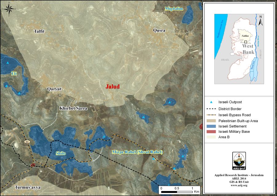
- Land Leveling in Jaloud South of Nablus Governorate
On January 15, 2014, herd of Israeli settlers from the illegal outpost of Yesh Kodesh stormed Jaloud village and stationed in Shu’ab Khallet Al-Wosta area in the village and razed the land. The targeted land area is 60 dunums owned by the heirs of the local resident Rasheed Mahmoud Al-Haj Mohammad. Mr. Abdullah Mohammad the head of Jaloud village council provided that a group of settlers from the nearby outpost of Yesh Kodesh razed the 60 dunums piece of land, while the settlers of the aforementioned outpost carrying out a systematic attacks against the resident of Jaloud and their properties under the protection of the Israeli Occupation Forces.
Yeash Kodesh is an illegal Israeli outpost established in December 2000. The outpost is located nearby the illegal settlements of Shilo and Shuvut Rahel east of Salfit and south of Jaloud village. It inhabited by 7 Israeli families living in 17 structures.
Jaloud is a Palestinian village located 25 lm south east of Nablus. The overall area of Jaloud is 16517 dunums of which 80 dunums only constitute the village’s built-up area. The village populated by 539 residents (PCBS 2014 Projections).
Jaloud is bordered by Qusra village and Megdalim Israeli settlement from the north, the illegal settlements of Shilo, Shuvut Rahel from the south, Qaryout village from the west, Duma from the east. See Map 2
Map 2: Location map of Jalud village
- Eviction of Khirbet Al-Kheil East of Sa’ir
On January 15, 2014, The Israeli Occupation Army invaded Khirbet Jouret Al-Kheil east of Sa’eer town northeast of Hebron Governorate and handed over six Palestinian families military demolition orders for their structures under the pretext of lacking building permits. Ziyad Abdel Mahdi Shalaldeh, one of the owners of the threatened structures indicated that according to the demolition orders the resident get time limit until February 12, 2014 o submit petitions to the Israeli authorities. He also added that orders targeted structures included 6 houses and 6 water wells. The Israeli military orders holding numbers (161066-161067-161068-161069-161070-161071). The owners of the targeted structures are:
- Ziad Abdel Mahdi Shalaldeh
- Ibrahim Mohammad Mustafa Shalaldeh
- Ahmad Mohammad Mustafa Shalaldeh
- Yasin Mohammad Mustafa Shalaldeh
- Walid Mohammad Mustafa Shalaldeh
- Faris Yasin Muhammad Shalaldeh
Mr. Kayed Jaradat the president of Sa’ir Municipality indicated that the demolition of the structures in Khirbet Jouret Al-Kheil will resulted in the displacement of 50 residents. He also added that the owners of the threatened structures get ownership documents for their lands that they build on. Mr. Jaradat said that the Israeli authorities intentionally aim to evict the families from Khirbet Jouret Al-Kheil to pave the way for the expansion of the adjacent Israeli settlement of Asfer. See Map 3

Map 3: Location of the targeted Palestinian structuresin Sa'ir town
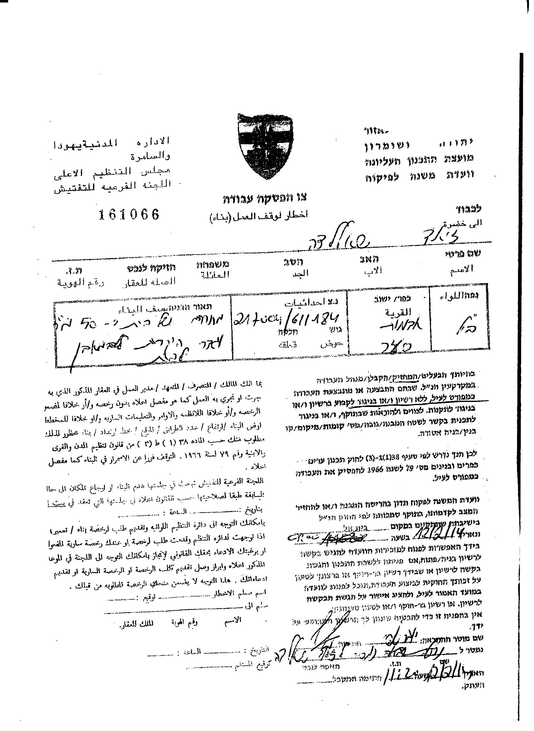
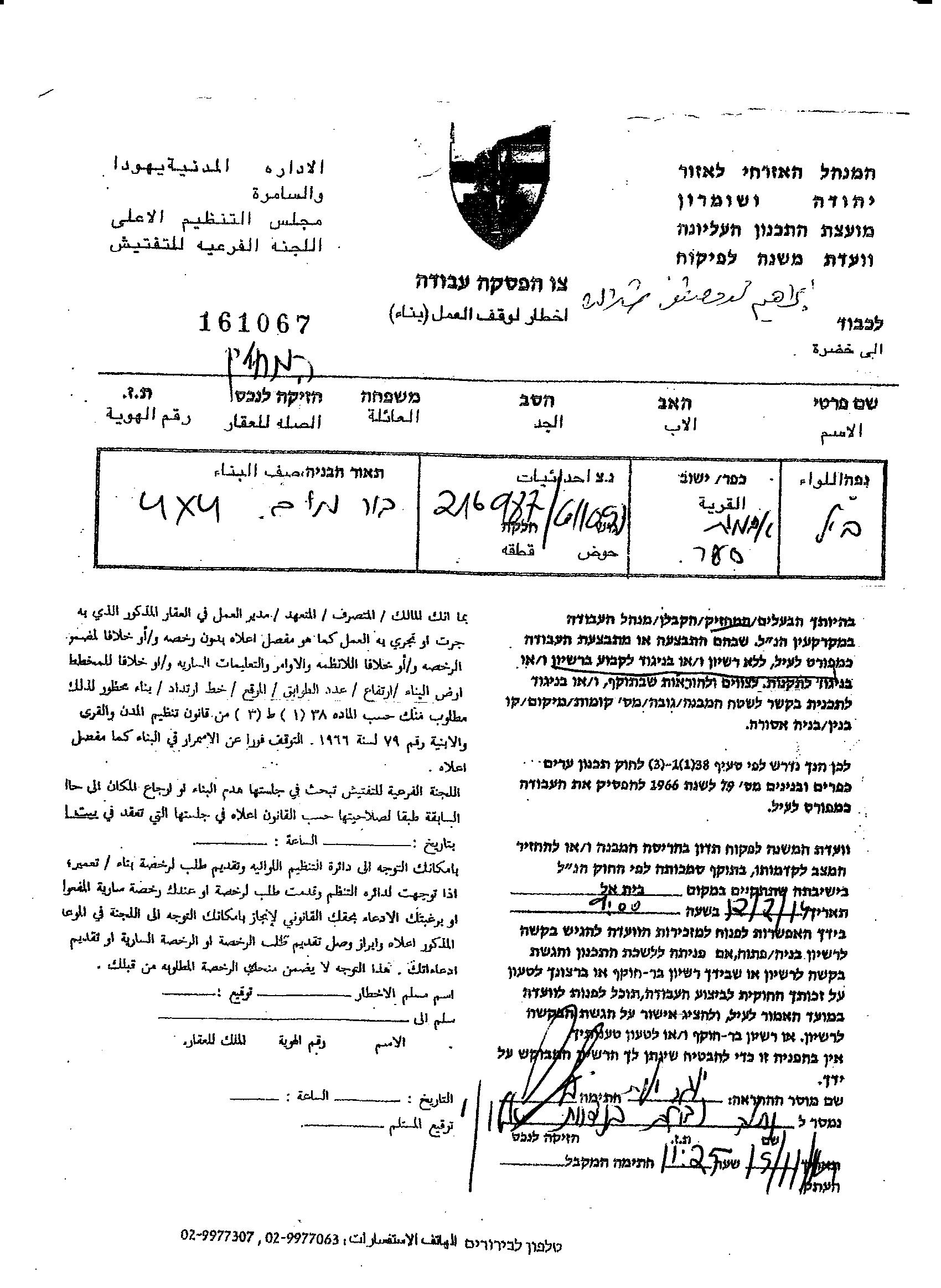
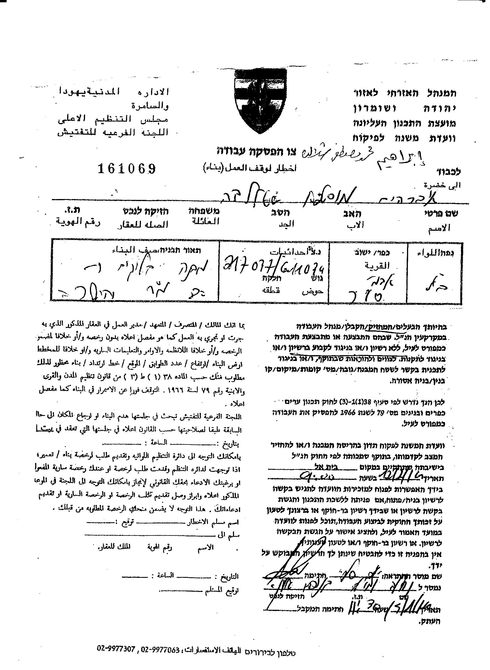


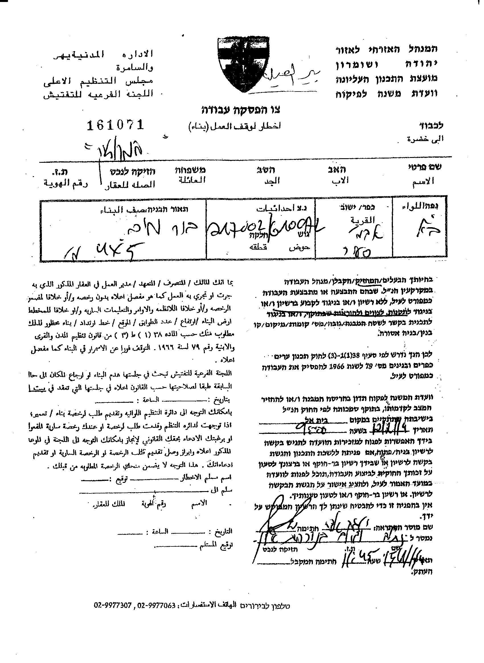
Photo 1-6: photocopies of the military orders in Sa'ir Town
Khirbet Jouret Al-Kheil located east of Sa’ir town northeast of Hebron Governorate. It is bordered by Sa’ir town from the west, Asfar settlement from the east, Kuziba from the north Ad-Dawara and Ras-At-Twil from the south.
- Irradiation of Khirbet ’Ein Karzaliya Bedouin Community-Jordan Valley
On January 8, 2014, the Israeli Army bulldozers accompanied with officers from what is so-called Israeli Civil Administration stormed Khirbet ‘Ein Karzaliya and demolished the entire Bedouin community under the pretext that the area classified “a closed military area” and allocated for military training. The destruction wave ended with the demolition of 16 structures (residential tents and animal sheds and barrackses) with losses exceeds 50 thousand NIS.
On January 13, 2014, the Israeli bulldozers accompanied with the Israeli Occupation Forces stormed Khirbet ‘Ein Karzaliya again and demolished the rebuilt structures for the second time and warned the residents from any future attempt to housing in the site.
Khirbet ‘Ein Karzaliya is a Palestinian Bedouin community located 3 kilometers southwest Al-Jiftlik in the middle of the Jordan Valley and about 20 kilometers east of ‘Akraba village southeast of Nablus Governorate.
- Land Razing around Ariel Settlement Industrial Zone
On January 12, 2014, large scale land leveling took place in the Palestinian lands around the Israeli industrial settlement of Ariel preparing for the construction of new factories in the site. The land razing concentrated in the lands nearby the Palestinian communities of “Abu Kayed and Abu Nasal west of Salfit city and related to the villages of Haris, Kifil Haris and Bruqin.
“Everyone know that Gush Etzion, Ma’aleh Adumim and Ariel settlement blocs will be always part of Israel………and the settlement of Ariel will be part of the State of Israel as the same as the city of Jerusalem”. Israeli PM, Benjamin Netanyahu, Israel Radio January 12, 2014.
It is worth pointed that Ariel settlement bloc consists from the residential settlement of Ariel, Ariel Industrial Park, Barqan Industrial Zone, Kiryat Netafim and Revava settlements. See Map 4

Map 4: The Ariel finger in Salfit Governorate
- Tenders to build 2314 housing units
From January 1, until January 21, 2014 the Israeli authorities approved a plans and issued tenders to build 2314 housing units in the Israeli settlements in West bank and East Jerusalem as follows:
On January 10, 2014, the Israeli Ministry of Housing and Construction and what is so-called Israel Land Authority ILA issued tenders for 1400 new housing units in Israeli settlements in the West Bank and East Jerusalem. According to the Israeli declaration the housing units distributed as follows: (600, Ramat Shlomo East Jerusalem)-(227, Efrat –Bethlehem)-(78 Alfe Minishe- Qalqiliya)-( 86, Karni Shomron-Qalqilya) -( 40, Ariel- Salfit)-( 75, Adam-Jerusalem)-( 24, Bitar ‘Illit-Bethlehem)-( 102, Immanuel-Qalqiliya)-( 169, Elkana- Salfit).
Moreover, the Israeli announcement included the re-marketing of land plots in East Jerusalem that were marketed in the past but did not have offers recorded on them. These plots include 182 housing units in Pisgat Ze'ev, 294 in Ramot, and 56 in Neve Yaakov. Altogether the re-marketed land accounts for 532 units.
Again on January 5, 2014: the Israeli authorities approved a plan to build 272 housing units in the settlements if (250 in O’ofra settlement and 22 in Karni Shomron).
later on January 20, 2014: the Israeli Civil Administration which falls under the auspices of the Israeli Defense Ministry, published plans to build new 381 new housing units in the settlement of Giv’at Ze’ev which is located five kilometers north of the city of Jerusalem.
The day after, on January 21, 2014: Approval of new plan to build 261 new housing units (256 in Neve Brat and 5 in Ariel). Neve Barat is an illegal Israeli settlement established in the year 1992 on an area of 871 dunums and inhabited by 950 settlers.
- New Settlement in Al-Sheikh Jarrah
On January 1, 2014, the Israeli daily newspaper revealed on a new plan to build Jewish learning center “Yeshiva” in the Palestinian Jerusalemite neighborhood of Al-Sheikh Jarrah. According to the newspaper, what is so-called Jerusalem Municipal Local Planning and Building Committee decided at the last minute to pull the plan from the day’s agenda deliberations.The proposed building supposed to be built on a piece of land owned by the Israel Land Authorities for the interest of Ohr Somayach teshuva yeshiva organization, and consist from nine above ground stories and three underground stories with a total area of 103,495 square meters. The building plan holding number 68858. See Map 5,
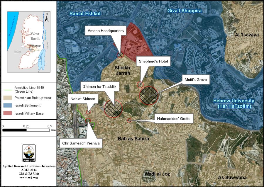
Map 5: The proposed plan in Ash Sheikh Jarrah neighborhood – Jerusalem
- New Settlement in Kufur ‘Aqab
On January 10, 2014, the Israeli weekly newspaper “Yersuhelim” reveal on a new Israeli colonial plan to build new illegal settlement nearby Kfur ‘Akab Palestinian neighborhood north of Jerusalem and south of Ramallah Governorate. According to the newspaper, Arieh King, the Director General of what is known as “Israel Land Fund” is behind the new colonial project. Arieh King, who is a member in the Israeli Municipality of Jerusalem, indicated to the newspaper that he is planning to build 40 one-story buildings with separate garden for each apartment on an area of 22 dunums. He also added that his organization (Israel Land Fund) that there are plans to move the Segregation Wall in the area to annex the new settlement to the Israeli side of the Wall and under the sovereignty of the Israeli Municipal boundaries of Jerusalem. King added that each building in the new settlement will cost $150,000 and the project is in its final stages and expected to be approved by the cabinet soon.
- Expanding of Bruchin settlement
January 1- January 7, 2014: Large scale land razing around the illegal Israeli settlement of Bruchin built on Bruqin village lands located to the west of Salfit Governorate. Israeli bulldozers leveling the lands to prepare the site for building new housing units in the settlement. It is worth mentioning that on June 9, 2013, the Israeli authorities approved a plan to build 550 housing units in the settlement of Bruchin. See map 6:
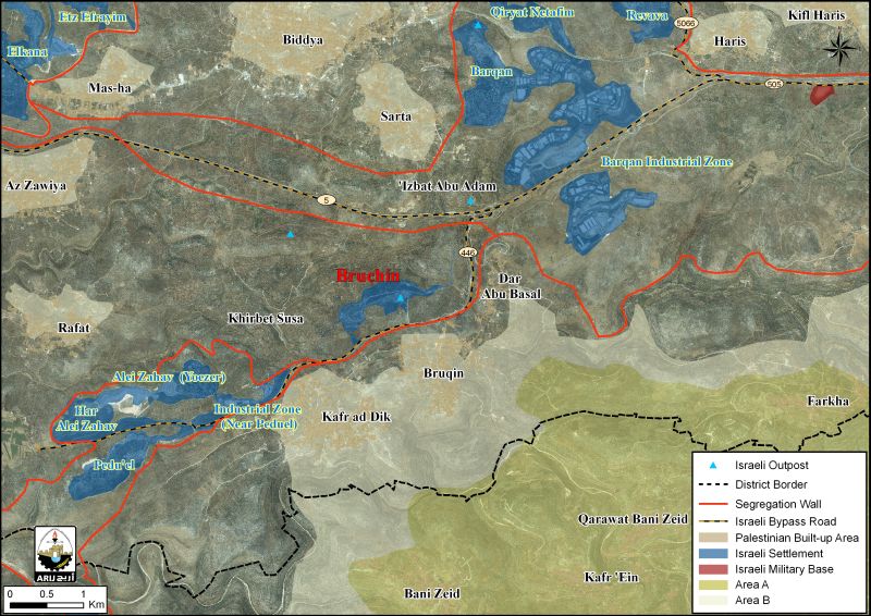
Map 6: Bruchin Settlement
Bruqin village: 13 kilometers to the west of Salfit city lies the Palestinian village of Bruqin. It is bordered by the Ariel settlements finger from the north, Salfit city from the east, Kafr Ad-Dik and Bani Zeid villages from the south, a number of Israeli settlements, Deir Ballut and Rafat villages from the west. The village has a total land area of 12,656 dunums, 678 dunums of which constitutes the built up area. The village has a total population of 3758 inhabitants (PCBS 2014 projections), most of who work in the agriculture sector.
The suffering of Bruqin residents started in the year 1981 when Israel established Ariel West Park Industrial Zone on the village lands; furthermore, in the year 1999, Bruchin settlement was built on Bruqin village lands, where the two settlements occupies an area or 2057 dunums (20% from the total village area).
New Israeli Outpost inside Hebron
On January 5, 2014, the Israeli Occupation Army along with officers from the Israeli Antiquities Authority stationed in Tal Al-Ramida 3 dunums piece of land under the pretext of archeological excavations. The targeted land owned by the local resident Rateb Salim Abu Heikal where the Israeli bulldozers uprooted more than 50 fruit and Almond trees. The owner of the targeted lands submitted a complaint to the Israeli police while the excavations taking place in the site until the date of writing this report.
It is worth mentioning that the goal behind the excavations in the site is to build an archaeological park to be called “Ramat Yeshai” very close to the illegal Israeli settlement “Admot Yeshai” (which was built in Tal Al-Rumeida inside Hebron in the year 1984), with a cost of NIS 7 million to be funded jointly by the Israeli Culture Ministry and the Israeli Civil Administration.
A s a matter of fact the Israeli proposed archeological excavations in Tal Al-Rumeida is no more than an Israeli maneuver to expand the existed nearby settlement of Admot Yeshai under the pretext of agrological excavations. See Map 7
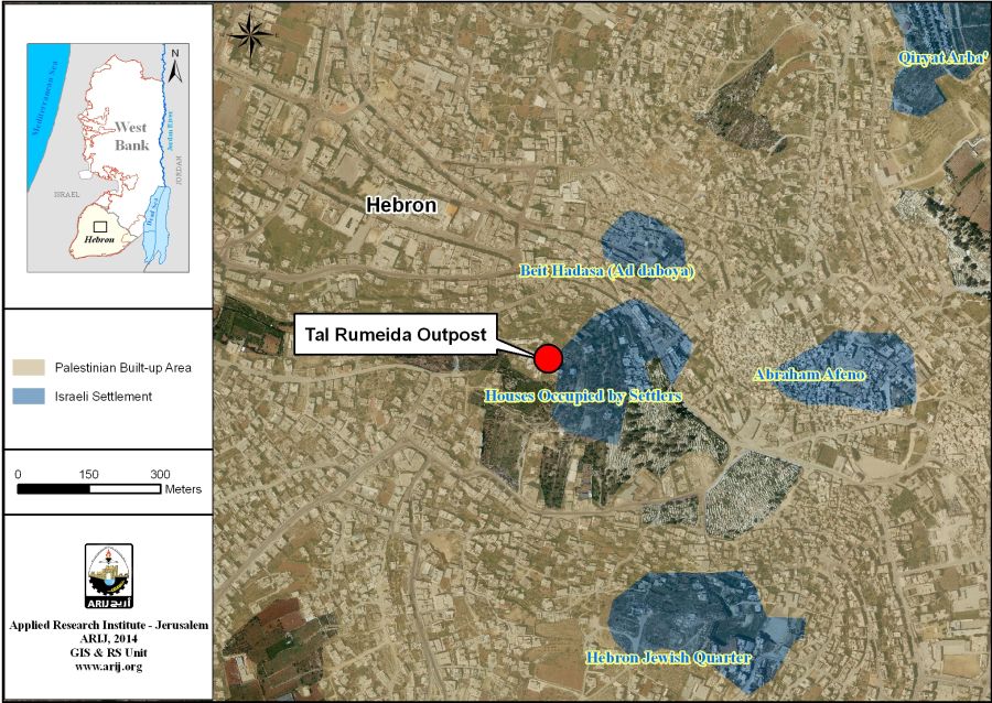
Map 7: Tel Ar Rumeida area – Hebron
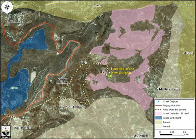
- New Illegal Outpost in Khallet An-Nahle Lands southwest Bethlehem Governorate
The story of the new outpost started in late October 2013, when a herd of Israeli settlers stationed on a hilltop in Khallet Al-Nahle community southwest of Bethlehem Governorate and started to install a tent and water tank electricity lines and other infrastructure in an attempt to settle in the site. Few days later the Israeli Occupation Army dismantle the tent in the site and called the settlers to leave the area but the Israeli settlers reinstalled the tent and settld in the site and on January 20, 2014 the settlers installed a new additional caravan in the outpost. See Photos below
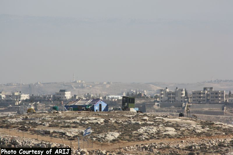

Photos 7 & 8: the tent, the water tank and the electricity lines

Map 8: The targeted land in Khallet Al-Nahle
Khallet Al –Nahle is a Palestinian village located south of Bethlehem Governorate. It is bordered by Artas town from the north, Ath-Thabra village from the south, the illegal Israeli settlement of Efrat as well as the Segregation Wall from the west, Khallet Al-Louza from the east.
To Conclude
The massive colonial activities practiced by the Israeli government mainly aim to foil the Palestinian- Israeli peace negotiations through imposing facts on the ground. The Israeli practices in the oPt constitute a grave breach for the International law rules and conventions where it refuses to comply with the International law and legitimacy for more than 60 years.
- Under the Universal Declaration of Human Rights adopted and proclaimed by General Assembly resolution 217 A (III) of, December 10, 1948, Article 17 reads: 'No one shall be arbitrarily deprived of his property.' Which means it bans Israel from destroying or confiscating the property of the Palestinians at any case.
- Moreover, articles 53 & 147 of the Fourth Geneva Convention of 1949 indicated that:Extensive destruction and appropriation of property not justified by military necessity and carried out unlawfully and wantonly. is a grave breach of the Convention.
- Also Art. 23 of the Hague Convention of 1907 also provides:In addition to the prohibitions provided by special Conventions, it is especially forbidden to destroy or seize the enemy's property, unless such destruction or seizure be imperatively demanded by the necessities of war.
- Article XXXI of the 1995 Oslo agreement Israelis forbidden from building or planning to any project or settlements or any colonial expansion or any plan that lead to change the status of the West Bank and Gaza Strip. The article provides “Neither side shall initiate or take any step that will change the status of the West Bank and the Gaza Strip pending the outcome of the permanent status negotiations”.
The existence of the Israeli settlements in the West Bank and their expansions are Illegal and contradicts with the international law rules, United Nations Security Council Resolutions such as 237 (1967), 271 (1969), 446 (1979), 452 (1979) ,465 (1980.
- Resolution 446 March 22, 1979 calls on Israel to rescind its previous measures and to desist from taking any action which would result in changing the legal status and geographical nature and materially affecting the demographic composition of the Arab territories occupied since 1967, including Jerusalem and, in particular, not to transfer parts of its own civilian population into the occupied Arab territories"
- Also the resolution 452 of the 1979 “calls upon the Government and people of Israel to cease, on an urgent basis, the establishment, construction and planning of settlements in the Arab territories occupied since 1967, including Jerusalem.”
- Furthermore the Forth Geneva Convention also states in Article 49 that “The occupying power shall not deport or transfer parts of its own population into the territories it occupies.” and Article 174 of the same convention “prohibits the 'extensive destruction and appropriation of property not justified by military necessity and carried out unlawfully and wantonly.”
- In May 2001, the head of the International Red Cross delegation to Israel and the Occupied Territories said that settlements are "equal in principle to war crimes". (Note: "The transfer, the installation of population of the occupying power into the occupied territories is considered as an illegal move and qualified as a 'grave breach.' It's a grave breach, formally speaking, but grave breaches are equal in principle to war crimes", Rene Kosirnik, head of the ICRC delegation to Israel and the OPT, press conference 17 May 2001).
Prepared By
The Applied Research Institute – Jerusalem
ARIJ


