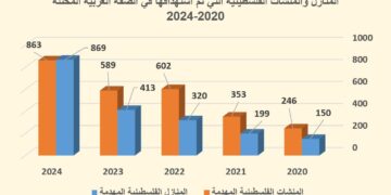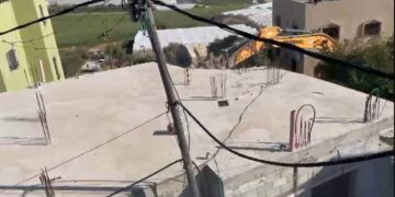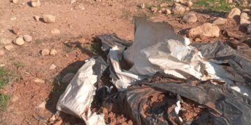
Violation: Ravaging more than 5 dunums of agricultural lands and uprooting 50 olive trees
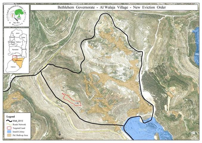
Location: Al Walaja- Bethlehem
Date: 09/12/2013
Perpetrators: The Israeli occupation and its bulldozers
Victims: Abu Ali family
Details:
On December 9, 2013, the Israeli bulldozers carried out ravaging an agricultural piece of land whose area is estimated to be five dunums. They also uprooted 50 olive trees aged 30 years and more in the area of Natof in Al Walaja. The land is a property of a family of Abu Ali. The agricultural lands are considered a source of income to some families in Al Walaja who depend on olive harvesting to make a living.
Amen Abu Ali, a landowner, told an LRC observer that: "The Israeli occupation ravages land in cold blood. They easily uproot trees that are tenths of years old. This is a crime against people of Al Walaja. Israel does not want to leave us in peace; they only want to steal our lands to expand their colonies."
It is worth mentioning that the ravaging is taking place near the Apartheid Wall in the northeastern part of Al Walaja in order to solidify its structure and devour hundreds of dunums of Al Walaja lands as well as to isolate it from Jerusalem.
Mr. Abdul Rahman Abu Al Teen (head of Al Walaja village council) stated to an LRC observer that: "We are really afraid that the ravaging of agricultural lands is meant to make a road linking Deir Kremzan to Har Gilo colony and the bypass near Al Walaja barricade. It is also reported that the Israeli occupation began executing a plan to build a national garden on the ravaged lands that is estimated to devour 1200 dunums of Al Walaja lands.
Al Walaja:[1]
5 kilometer northwestern Ramallah, Al Walaja is surrounded by Battir (west), Sharafat (east), and Beit Jala (south). Al Walaja has a total population of 2041 people according to statistics conducted in 2007. It has a total area of 4327 of which 446 dunums are a built-up area of the village.
The Israeli occupation devoured 155 dunums of the lands of the village for two colonies. The first one is Har Gilo which was built in 1972 and confiscated 104 dunums of the village. It is inhabited by 365 colonists. The second is Gilo which was built in 1981 and devoured 51 dunums. It is inhabited by 27569 colonists. Moreover, bypass number '436 took over 246 dunums of the village lands in addition to the Apartheid Wall that damaged 69 dunums and is expected to isolate 4171 dunums. The length of the wall built on Al Walaja lands is 6942 meters.
According to Oslo Accords, 3% of Al Walaja is under Area B (PA is in charge of civil matters with Israel responsible for security). However, most of the village lands (97%) is under Area C (Israel maintains full security and administrative control). Here are the area in dunums:
- Area B (115) dunums
- Area C (4056) dunums
Prepared by
The Land Research Center
LRC