The morning of December 1, 2012, was an exceptional day for the Palestinians in the West Bank, Gaza Strip and in the Diaspora, where the world waked up on the Birth of the New State of Palestine after the United Nation General Assembly adopted a resolution that ended with voting for the interest of the Palestinian legitimate and historical rights – even after 64 years late- that took place in on November 30, 2012 where Palestine became the State No. 194 with the status of “a non-member observer status state”.
For the Palestinians, their exultation for the vote is justified, where they partially won their legitimate rights to have their State – even it is on 22% only from historical Palestine- and even their new state didn’t get full membership in the International Agency, and even more, their new State was born occupied and without sovereignty, but they still flaunt with hope, based on coexistence, good neighborhood and real desire for achieving peace, and even that the hope started fading and almost disappeared many of the Palestinians including the politicians clinging to hope as part of their believes that once hope leaves the anarchy and violence will control the scene.
For our neighbors in Israel, they have absolutely different point of view where the Israeli extremist right wing government didn’t hide their anger and condemning for what it considered as breaching with the signed agreements with the Palestinians!!!!!! and more tat that the Israeli prime Minister Benjamin Netanyahu, and according to his ideological believes directed a message of defy to the UN General Assembly and to the whole world stating: ‘The response to the attack on Zionism and the State of Israel must reinforce and underscore the implementation of the settlement plan in all areas in which the Government decides regarding settlement. These are not my words. These are the words of the government of Prime Minister Yitzhak Rabin and this is the language of the Cabinet’s 1975 decision in the wake of the UN decision that equated Zionism with racism.
Today we are building and we will continue to build in Jerusalem and in all areas that are on the map of the strategic interests of the State of Israel. The Palestinian Authority’s one-sided step at the UN constitutes a gross violation of the agreements that have been signed with the State of Israel; accordingly, the Government of Israel rejects the UN General Assembly decision.’
Netanyahu remarks at the start of the weekly Cabinet meeting, December 2, 2012.
If we delve deeper in the words of the Israeli Premier, we can easily realize that the Israeli Prime Minister and according to his colonial and ideological spirit sees what’s nobody in the world can see, where he considers the two state solution that the UN vote (based on) as an existential threat for the “Jewish State of Israel” the Sate that spreads from Galilee- north, Negev- south, Egypt west, Jordan east, Judea and Samaria including Jerusalem, with its strategic interest on the colonial Israel map, in the middle.
Later on, and just few days after the ill-conceived remarks of the Israeli prime minister his words started to be translated on the ground by launching a Hysterical wave of building housing units in the illegal settlements in the West bank and Jerusalem where within 15 days only plans to build (12,244) housing units have been approved where (10,558) housing units to be built in the illegal outpost in the occupied Eastern part of the city of Jerusalem. See table 1
SETTLEMENT NAME | LOCATION | NO. OF APPROVED H. UNITS |
Gilo | Jerusalem | 942 |
Ramat Shlomo | Jerusalem | 1500 |
Giv’at Hamatos | Jerusalem | 4627 |
E1 | Jerusalem | 2490 |
Giv’at Ze’ev | Jerusalem | 831 |
Har Homa | Jerusalem | 168 |
Giva’ot | Bethlehem | 523 |
Bitar ‘Ilit | Bethlehem | 398 |
Efrat | Bethlehem | 207 |
Karni Shomron | Salfit | 350 |
Immanuel | Nablus | 102 |
Adam | Ramallah | 106 |
Total | ***** | 12,244 |
As a matter of fact , the Israeli tremendous settlement plans approved within two weeks reflect the Israeli government attitude toward peace and two-state solution where in insist on escaping forward and adopting “brinkmanship” as an approach which will lead sooner or later to a dead end for peace efforts.
Archeological Excavations Took Place in Al Walajeh Northwest of Bethlehem Governorate
Since December 12, 2012- present, workers from what is so-called “Israel Antiquities Authority” conducting excavations in “’Ein Al-Hania” historical water spring north of the village of Al-Walajeh located northwest of Bethlehem Governorate. ARIJ field workers visited Ein al-Hania site which located in the no-man’s land adjacent to the Armistice Line of 1984 (Green Line) ,where the Israeli settlers of the nearby settlements of Gilo and Har Gilo conducting regional rituals in the place while Israeli authorities are working in the site in an attempt to annex the historical area to the Israeli side of the Segregation Wall. It is worth mentioning that a historical Byzantine Church locating in the site of “Ein Al-Hania”. See Photos 1-4
 | |
| |
Photos 1-4: a historical Byzantine Church located in the site of “Ein Al-Hania”
Al Walajeh, a small Palestinian village located about 4 kilometers to the northwest of Bethlehem city and 8.5 km to the southwest of the city of Jerusalem. The village houses a population of approximately 1,695 residents (PCBS 2012), and bordered by Battir and Husan villages from the southwest, by Sharafat village and Gilo settlement (established in 1971) from the east and by Har Gilo settlement (established in 1972) from the southeast, and the rest of the village is loop by the Israeli bypass road 60.
Its is worth mentioning that Al Walajeh Before the 1948 war, was spread over an area of 17.793 km2 and its boundaries extended westwards beyond the Armistice Line (the Green Line), and after the 1948 war, the village lost 75% of its lands and came to spread over a total land of 4.403 km2 (24.8 % of its original area).
Glance about the Segregation Wall in Al Walajeh Village
According to the updated Wall plan of April 30, 2007, the Wall will place Al-Walajeh village in an isolated enclave, sealed off from all directions, east, west, north and south and from the neighboring Palestinian communities; Battier, Hussan, Beit Jala and from Bethlehem city center. The Wall, according to the map, was shifted northwards to include the neighborhood of ‘Ein Al Juwaiza on the Palestinian side of the Wall, but sealed off the village completely from its southern part with a 2.5 km long Wall that will run alongside bypass road number 436.
In Total, the Israeli segregation Wall plan will extend for 7.9 km on the lands of Al-Walajeh, of which 3.5 km will be barbed wires. The Wall will isolate a total sum of 2210 dunums of the village’s lands that is 50.2 % of the total village area. The road protection strip (the road security buffer zone) will cause the isolation of an additional 1100 dunums of lands from Al-Walajeh village, where these lands will fall south of the Wall and will be inaccessible to the Palestinian residents. Currently, 1.2 km of concrete wall exists around the village, 1.2 km is under construction and 5.5 km are in planning phase to be constructed around the village before the end of 2012.
Expansion of Nevi Daniel Outpost North on Al Khader Village Lands
On December 16, 2012 the Israeli Occupation installed new caravans (mobile homes) in the a new site in the illegal outpost of “Nevi Daniel North” outpost that illegally built on Ein al Qassis area west of Al-Khader village. In an interview with ARIJ filed workers Mr. Mahmoud Issa indicated that the Israeli settlers are illegally expanding on the nearby hill tops owned by Al-Khader residents supported by the Israeli Army and the Israeli government.
He also added that during the last week the Israeli bulldozers are working on the targeted hilltop under the protection of the Israeli Army who claims that the lands are classified as closed military area ten years ago. See the pictures below:
| |
Pictures for the land leveling and new caravans in Nevi Daniel North outpost
The Outpost of Nevi Daniel North ‘Hananya’
It was illegally established in January 2002. It is located about 1.5 kilometers north of Nevi Daniel settlement and 1.8 kilometers west of Al-Khader village. The outpost started out with one Israeli settler who coarsely took control of one of the mountain tops west of Al-Khader village and set-up a mobile ‘caravan’ (house) in the area, encircled the location with barbed wires and brought protection trained dog to protect his property. The settler, who received support and protection from the Israeli Army while setting up the location of the outpost, has advocated many other settlers to come and join him in the area where he lives.
Since its establishment, the outpost got bigger in size with 12 caravans (mobile homes) in the site inhabited by 16 Israeli settlers, who enjoy basic services and good infrastructure (water, electricity, roads), all come with the courtesy of the Israeli authorities in spite the fact that the outpost is illegal.
Al-Khader Village …. Location & Population
Al-Khader village, a Palestinian community located some 4.5 kilometers east of Bethlehem city. It is bordered by Husan and Battir villages from the west and northwest, Al Doha and Beit Jala cities from the north and northeast, and Al Duheisha Refugee camp and Artas village from the south. The built-up area of Al- Khader village spreads on 601 dunums of land, about 3% of the village’s total land area (20,090 dunums). The village is a home to 11,062 inhabitants (PCBS 2012), most of who work in the agriculture sector. The village’s rich fertile soil has made farming and agriculture feasible on the land; therefore, agriculture has been and is still considered the major source of income for many families of the village.
Strangulated by the Occupation
Al Khader village is one among many Palestinian villages which were severely affected by the Israeli colonial and expansionist activities. Throughout the years of the Israeli occupation to the Palestinian territory, the village lost 2791 dunums (13.8% of the village’s total area) of its lands for the construction of six illegal Israeli settlements. Furthermore, the Israeli Segregation Wall constitutes another Israeli colonial tool to loot as much lands as possible from Al-Khader village, where it stretches 6.7 km on the lands of the village and cuts most of the village’s agriculture lands and open spaces behind it. When completed, the Segregation Wall will end up isolating 15,144 dunums (75.4%) of the village’s total land area, including the Israeli settlements established on the village’s land and annex them to Israel’s proper.
Land Leveling in Nahalin Village
On December 19, 2012 , the Israeli bulldozers protected by the Israeli Army forces stationed in Ein Faris area west of Nahalin village , and started without a prior notification to razing 25 dunums piece of land which resulted in the destruction of more than 250 trees (olive and almonds) owned by the local residents:
Amin Mohammad Amin Najajreh
Abdel Rahman Mohammad Amin Najajreh
Ahmad Mohammad Amin Najajreh
‘Adel Mohammad Amin Najajreh
Mohammad Abdel Rahman Sha’ban Shakarneh
After they finished razing in Ein Faris area the Israeli bulldozers stationed in Wad Salim area and started leveling 15 dunums of land owned by the local residents:
Abdel Halim Ibrahim Youseph Shakarneh
Hilmi Ahmad Mousa Najajreh
Mohammad Ahmad Mousa Najajreh
Rateb Ahmad Mousa Najajreh
Hussein Ahmad Mousa Najajreh
Na’im Ahmad Mousa Najajreh
The leveling ended with the destruction of more than 150 trees. See photos of the targeted lands:
| |
| |
Nahalin is one of the villages of Bethlehem Governorate, populated by 7,727 residents (PCBS 2012) and stands on a total area of 17,250 dunums. It is bordered by Husan village and the illegal Israeli settlement of Betar ‘Illit from the north, the illegal Israeli settlement of Rush Tzurim from the south, Artas village as well as the illegal Israeli settlement of Neve Daniel from the east, Al Jab’a village and the illegal Israeli settlement of Geva’ot from its west.
The Geopolitical Division of Nahalin Village
According to the Oslo II Interim agreement of 1995, Nahalin village lands, as well as the rest of the Palestinian Territory, were divided into areas A, B and C. In Area A, the Palestinian National Authority has complete autonomy over administrative and security issues, where in area B, Palestinians have full control over the civil administration and Israel continues to have overriding responsibility for security; while in Area C, Israel has full control over the security and administrative issues. Table 2 clarifies the classification of lands of Nahalin village:
Table 2: Classification of Nahalin Lands According to Oslo II Interim Agreement of 1995 | ||
Land Classification | Area-Dunums | %from the total Town lands |
Area A | 0 | 0 |
Area B | 1,132 | 6.6 |
Area C | 16,118 | 93.4 |
Total | 17,250 | 100 |
Source: ARIJ Geo-informatics Department 2012 | ||
Moreover, the village of Nahalin is surrounded from its four directions with a set of Israeli settlements, Rush Tzurim, Neve Daniel, Geva’ot and Betar ‘Illit, which were built on its lands and caused the confiscation of 1411 dunums (8.2%) of its total area (17250 dunums). See table 3:
Table 3: illegal Israeli Settlements Built on Nahalin Village Lands | |||
Settlement Name | Establishment Date | Total area of settlement (Dunums) | Population (2009) |
Rush Tzurim | 1969 | 893 | 364 |
Neve Daniel | 1982 | 584 | 1,600 |
Giva’ot | 1984 | 135 | 44 |
Betar ‘Illit | 1985 | 4,686 | 29,000 |
Total | ***** | 6,298 | 31,008 |
Source: ARIJ Geo-informatics Department 2012 | |||
In addition, the construction of the Israeli Segregation Wall will put Nahalin village along with six neighboring Palestinian communities (Battir, Husan, Wad Fukin, Al Jab’a, Khallet Al Balluta, Khirbet Beit Skariya and Khallet ‘Afaneh) in an enclave and segregate them from the center of life in Bethlehem Governorate. See map 1
|
Demolition Orders in Wadi Al-Nis South of Bethlehem Governorate
On December 25, 2012, the Israeli Army forces stationed in Jabal Abu Nassar area in Wadi Al-Nis village south of Bethlehem Governorate and handed over Palestinian residents military notification orders to stop working in five structures in the site under the pretext of lacking building permits. Table 4 below shows the details of the targeted structures in Wadi Al-Nis village:
Table 4: Details for the targeted Structures in Wadi Al-Nis | ||||
No. | Owner’s name | Construction Area- m2 | Year of Construction | Expected Loses-NIS |
1 | Sa’id Khalil Hammad | 300 | 2012 | 140,000 |
2 | Osama Naji Hammad | 120 | 2012 | 100,000 |
3 | Anwar Saqer Hammad | 110 | 2012 | 120,000 |
4 | Hasan Youseph Hammad | 240 | 2011 | 180,000 |
5 | Nasri Mohammad Hammad | 100 | 2012 | 70,000 |
Source: ARIJ field Workers- Wadi Al-Nis V. Council | ||||
| |
| |
| |
Wadi Al- Nis village located 6.8 km south of Bethlehem. It is bordered by Marah Ma’alla village from the north, Jouret ash Sham’a and Al Ma’sara villages from the east, Umm Salamuna village from the south, Efrat and Migdal ‘Oz settlements from the west, and the racist Segregation Wall, which Israel started to construct in June, 2002.
According to Oslo Agreement of 1995, 102 dunums (1% of the total area of the village) were classified as area B, and the remaining part of the village, 10335 dunums (99% of the total area) were classified as area C. The majority of the agricultural and open areas lie in area C, which is under full Israeli control. See Table 5:
Table 5: Land classification in Wadi Al-Nis according to Oslo II Agreement of 1995 | ||
Land Classification | Area (dunum) | % of the Total Area |
Area A | 0 | 0 |
Area B | 102 | 1 |
Area C | 10335 | 99 |
Total Area | 10437 | 100 |
Source: ARIJ Geo-informatics Department 2012 | ||
Wadi Al- Nis village is subjected to various blockades such as, one permanent and one mobile checkpoint, an iron gate, and to earth mounds at the village entrances (Wadi Al-Nis Village Council, 2012).
Israeli Settlement Activities in Wadi Al- Nis village
After the Israeli occupation of the West Bank and Gaza Strip in 1967, the Israeli authorities confiscated large areas of the Palestinian territories for the construction of Israeli settlements, bypass roads and military bases. Wadi Al-Nis village, as well as other Palestinian villages and towns in the West Bank, was exposed to Israeli violations over the continuous years of Israeli occupation, namely: 2808 dunums of the village land was confiscated for the construction of four Israeli settlements, all located in the Gush Etzion block .See Table 6
Table 6: Israeli Settlements built on Wadi an Nis village land | ||||
Settlement | Year of Establishment | Population | Total Area of Settlement | Seized land of the Village (dunum) |
Efart | 1979 | 8,200 | 2,180 | 1713 |
El’azar | 1975 | 1,547 | 536 | 536 |
Rosh Zurim | 1969 | 485 | 893 | 3 |
Neve Daniel | 1982 | 1,760 | 584 | 556 |
Total | 11,992 | 4,193 | 2,808 | |
Source: ARIJ Geo-informatics Department 2012 | ||||
The Segregation Wall in Wadi Al-Nis
According to the latest update on the route of the Segregation Wall in the West published on the Israeli Ministry of Defense webpage in April, 2007, (2.86)km of wall will be built on Wadi an Nis village lands ,isolating 9470 dunums (%90.7 of the total area of the village) within the western separation area, that will be annexed to the Israeli side of the Segregation Wall which will include 11 Israeli settlements (Gush Etzion Settlements) along with nine Palestinian communities (Battir, Husan, Nahalin, Al Walajeh, Wadi Fukin, Al Jab’a, Khirbet ‘Afana, Khirbet Al Balluta, Beit Sakariya). The construction of the Segregation Wall in Wadi Al-Nis started in the year 2007, when the Israeli bulldozers razed agricultural lands and uprooted horticultural trees in preparation for the construction of the wall, causing severe damages and material losses to the agricultural sector. Moreover, the Israeli bypass roads No. 3698 and No. 60 extend for about 5.6km on Wadi Al- Nis village lands .See Map 2
|
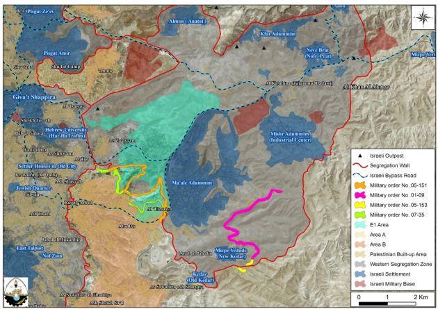
Amending Military Orders Targeted Abu Dis & Al Izzariyya Arab Al-Sawahreh and At-Tur Communities East of the City of Jerusalem
On December 15, 2012, the Israeli Occupation Forces handed over the residents of Abu Dis and Al-Izzariyya , Arab Al-Sawahreh and At-Tur south east of the city of Jerusalem four military orders ( amendment to a previously confiscation orders) to complete the construction of the Segregation Wall and “Fabric of Life” road around Ma’ale Adumim settlement east of Jerusalem.
The first military order holding No. (05/153/T)- Extension of Validity- states the confiscation of 80.1 dunums from Abu Dis town and Arab Al-Sawahreh community for security pretexts to complete the construction of two sections of the Segregation Wall around Ma’aleh Adumim settlement bloc (Kedar and Mitspe Yadoud –New Kedar sections), where the military orders was issued for the first time in August 5, 2005 and the new amendment for the purpose of extending its validity until December 31, 2013. See table 7
Table 7: Israeli Military Order No. (05/153/T) | |||
No. | Community Name | Pelvis No. | Targeted Site |
1 | Abu Dis | 4 | Um-Al-Rayyan |
2 | Arab Al-Sawahreh | 5 | Marj Al-Sultan, Wadi At-takhbor and Dahret Al-Matraha |
Total | 80.1 | ||
Source : Source: ARIJ Geo-informatics Department 2012 | |||
The second military order holding No. (07/35/T)- Extension of Validity- states the confiscation of 386.34 dunums from Al-Izzariyya, Abu Dis, At-Tur towns for security pretexts to construct what is called “Fabric of Life” road where the military order was issued for the first time in October 4, 2007 (was holding no. (07/35/T)) While the new amendment for the purpose of extending its validity until December 31, 2013. It is worth mentioning that the aforementioned military order was issued for the purpose of constructing a road that links the southern parts of the West bank (Bethlehem and Hebron) with Jericho and Jordan Valley area while completely isolating the eastern occupied part of the city of Jerusalem from the rest parts of the West Bank where it stretches 4.6 km from Al-Container checkpoint northwest of Bethlehem through Abu Dis and Al-Izzariyya to the west, At-Tur and Za’ayem reaching to Hizma and ‘Anata through a proposed tunnel that ended away from bypass road No. 1 which is planned to be used only for the Israeli settlers while the Palestinians will use a new road according to the military order. See table 8
Table 8: Israeli Military Order No. (07/35/T) | |||
No. | Community Name | Pelvis No. | Targeted Site |
1 | Al-Izzariyya | 4 | Araq ‘Azar, Al-Khalila, Al Hud |
5 | Daher Brucha | ||
6 | Marj Al-Zoun, ‘Arqoub Wijeh Ad-Deib, Sha’b Subhi, Ras Al-Izzariyya and Al-Martama | ||
2 | Abu Dis | 4 | Daher Al-Karareet |
3 | At-Tur | 8 | Ras Abu Sbeitan, ‘Ar Nazel, Mojeir Jareh |
Total | 386.34 | ||
Source : Source: ARIJ Geo-informatics Department 2012 | |||
The third military order holding No. (05/151/T)- Extension of Validity- states the confiscation of 415.13 dunums from Al-Izzariyya lands for security purposes to complete the construction of the Segregation Wall section around Ma’aleh Adumim settlement bloc – West Ma’aleh Adumim section. The military order was issued for the first time in August 15, 2005 while the new amendment for the purpose of extending its validity until December 31, 2013. See table 9
Table 9: Israeli Military Order No. (05/151/T) | |||
No. | Community Name | Pelvis No. | Targeted Site |
1 | Al-Izzariyya | 5 | Daher Brucha |
6 | Marj Al-Zoun, ‘Arqoub Wijeh Ad-Deib, Sha’b Subhi, Ras Al-Izzariyya and Al-Martama | ||
Total | 415.13 | ||
Source : Source: ARIJ Geo-informatics Department 2012 | |||
The fourth military order holding No. (01/09/T)- Extension of Validity- states the confiscation of 506 dunums from Arab Al-Sawahreh and Abu Dis lands for security pretexts mainly to construct the Segregation Wall section in Ma’aleh Adumim area – Mitzpe Yadoud (New Kedar) section. The military order was issued for the first time in the year 2009 while the new amendment for the purpose of extending its validity until December 31, 2013. See table 10
Table 10: Israeli Military Order No. (01/09/T) | |||
No. | Community Name | Pelvis No. | Targeted Site |
1 | Arab Al-Sawahreh | 5 | Marj Al-Sultan |
2 | Abu Dis | 6 | Um Rayyan, Safeh and Wadi Abu Hindi |
7 | Al-Makhbiya, Al-Sawya, Daher Shmeis ‘Azour and Sidet ‘Azour | ||
Total | 506 | ||
Source : Source: ARIJ Geo-informatics Department 2012 | |||
|
Without doubt, the Israeli government and through these military orders is moving forward with its isolation policy through the construction of the Segregation Wall that interrupt the geographical contiguity of the Palestinian Territory and turn it into enclaves and completely isolating the occupied eastern part of the city of Jerusalem from the rest parts of the West Bank and reviving what is known as E1 plan which is actually eliminate any chance for achieving lasting and durable peace agreement between Israel and the Palestinians that based on two state solution on 1967 borders and East Jerusalem as a capital of the future Palestinian State.
To Conclude
The Israeli seizing and razing of Palestinian-owned lands and destroying the Palestinian properties is Illegal and constitute a grave breach for the International law rules and conventions, some of which are listed below:
Article 53 & 147 of the Fourth Geneva Convention of 1949 indicated that: Extensive destruction and appropriation of property not justified by military necessity and carried out unlawfully and wantonly, is a grave breach of the Convention.
Moreover Art. 23 of the Hague Convention of 1907 also provides: In addition to the prohibitions provided by special Conventions, it is especially forbidden to destroy or seize the enemy’s property, unless such destruction or seizure be imperatively demanded by the necessities of war.
Also under the Universal Declaration of Human Rights adopted and proclaimed by General Assembly resolution 217 A (III) of, December 10, 1948, Article 17 reads: ‘No one shall be arbitrarily deprived of his property.’ Which means it bans Israel from destroying or confiscating the property of the Palestinians at any case.
‘Article 12’ of the International Covenant on Civil and Political Rights Everyone lawfully within the territory of a State shall, within that territory, have the right to liberty of movement and freedom to choose his residence.
Article 13 of the Universal Declaration of Human Rights,: Everyone has the right to freedom of movement and residence within the borders of each State.
Related Cases