
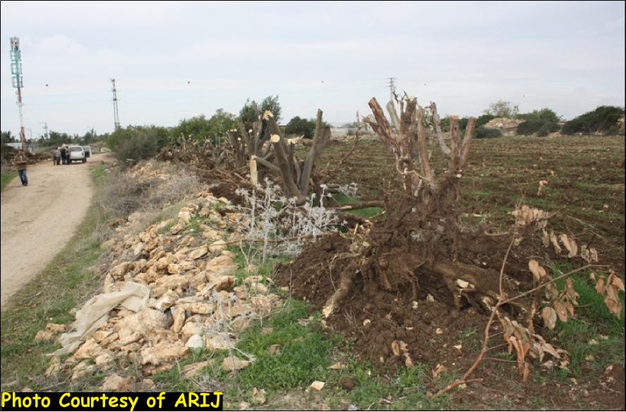
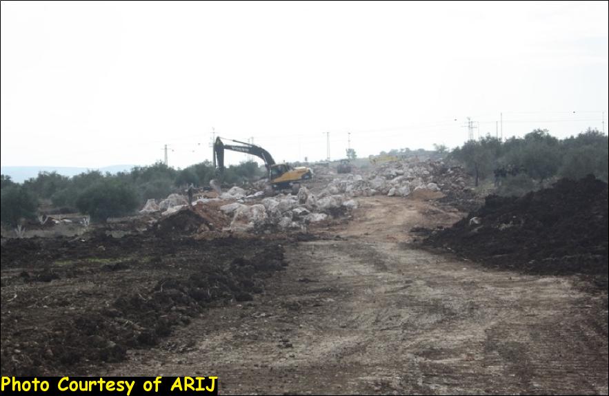
Large scale land razing for hundreds of dunums of Azzun Al-‘Atma village lands south of Qalqilyah city is taking place to build the northern and western sections of the Israeli Segregation Wall. The destruction and razing started in November 2, 2011, when the Israeli bulldozers protected by Israeli occupation stationed in Bir Ash-Shilla and Az-Zawiye areas and started razing vast areas of agricultural lands owned by Azzun Al-‘Atma local residents. The razing of lands continues till the date of writing this report.
In a field visit to Azzun Al-‘Atma village conducted by ARIJ field team on December, 8, 2011, a series of losses were recorded due to the Israeli destruction campaign:
• Uprooting and destroying of more than 800 olive trees.
• Destruction of nine green houses.
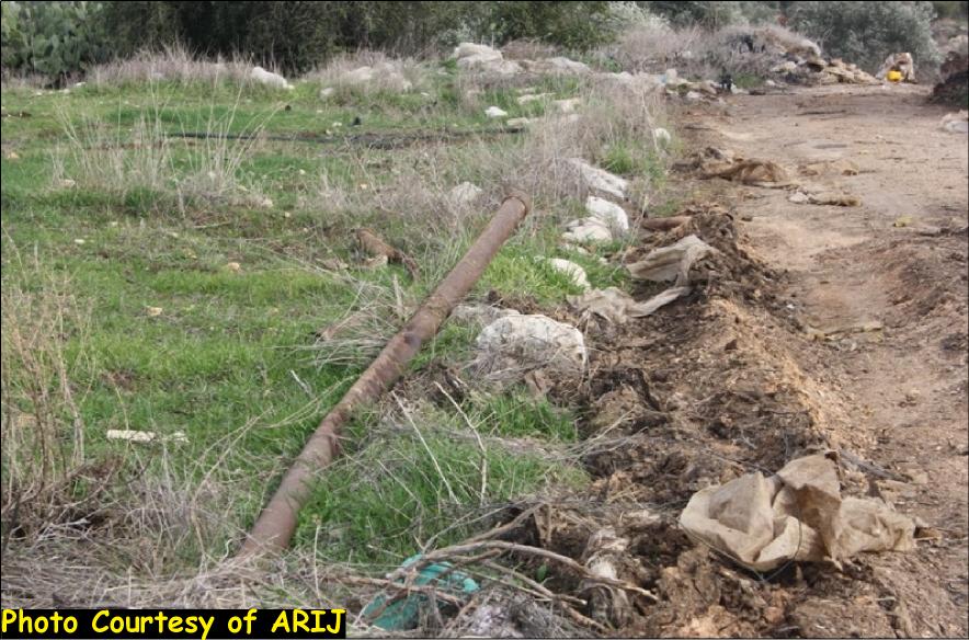
• Destruction and dismantling of more than 5000 irrigation pipelines.
• Demolition of 5 water tanks used for agriculture purposes (four iron tanks, one cement tank).
• Destruction of 20 km agriculture roads.
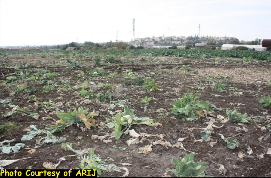
• Razing of 47 dunums of agricultural lands cultivated with broccoli.
• Razing of 25 dunums of lands cultivated with citrus trees.
Local farmer Ibrahim Abdullah Mohammad Omar, and in an interview with ARIJ field team indicated that the Israeli bulldozers razed his 20 dunums piece of land which was cultivated with potatoes and other kinds of vegetables, where most of the cultivations were razed and uprooted by the Israeli bulldozers; More than that, his land will be isolated behind the Segregation Wall path, within the western segregation zone, which eventually will lead to the loss of large portions of his land for the Wall. Once the wall is completed, the access to Mr. Omar’s land will be only through a wall gate after issuing a special permit from the Israeli Civil Administration.
Another affected farmer interviewed by ARIJ field team is Mofeed Khalid Mahmoud Ali, who owns 25 dunums piece of land. So far, the Israeli bulldozers razed two dunums of his land in addition to the demolition of two green houses, one water tank, a room and a store.
It is worth mentioning that in the year 2010, the Israeli Supreme Court issued its final decision to build the northern and western sections of the Segregation Wall in the village in response to an appeal filed by residents of Azzun Al-‘Atma to the court in the year 2007 to change the route of the Wall due to the catastrophic results that the wall will cause if built on lands of the village.
Follow are the names of local Palestinian farmers affected by the Israeli razing to build to the Segregation Wall in Azzun Al-‘Atma village until December 10, 2011: Mohammad Youseph Saleh Al-Sheikh, Omar Faris Omar Ahmad, ‘Ali Hussein Taha, Hamadallah Mahmoud Ahmad , Mohammad Hasan Salameh , Mohammad Ahmad Ahmad, Abdel Karim Hussein Saleh, Mahmoud Hussein Saleh, Abdel Rahman Al Faris, Abdel Karim Mustapha Salameh , Munther Abdel Karim Salameh, Youseph Faris Ahmad, Faris Youseph Ahmad, Ahmad Youseph Faris , Yoseph Kamel Al-Hajj , Hashim Abdel Karim Al Hajj Youseph , Mufid Abdel Halim Hajj Youseph , Abdel Halim Hajj Youseph , ‘Ali Hamad ‘Ali , Ibrahim Mahmoud Youseph Ayyoub, Ibrahim Abdullah Omar, Mofid Khalid Mahmoud ‘Ali , Abdel Karim Khalid ‘Ali , Farid Khalid ‘Ali, ‘Ali Mahmoud Youseph Ayyoub, Hani Mohammad ‘Amer, Ahmad Mohammad ‘Amer. (Source ARIJ field team 2011).
Azzun Al-‘Atma, location and population:-
Azzun Al-‘Atma is a Palestinian village located about 3 km east of the Green Line (Armistice Line of 1949), and about 8.5 km southeast of Qalqilyah city. The village is inhabited by 2126 residents (PCBS 2010).
Azzun Al-‘Atma’s lands extend from Beit Amin village in the north, to Al Zawiya village in the south as well as from the Green Line (Armistice Line 1949) in the west to the vicinity of Sniriya village in the east. However, ‘Azzun ‘Atma village is located within Sniriya village cluster which includes Sniriya, Beit Amin and ‘Azzun ‘Atma villages with a total area of 13,270 dunums.
The Segregation Wall in Azzun Al-‘Atma
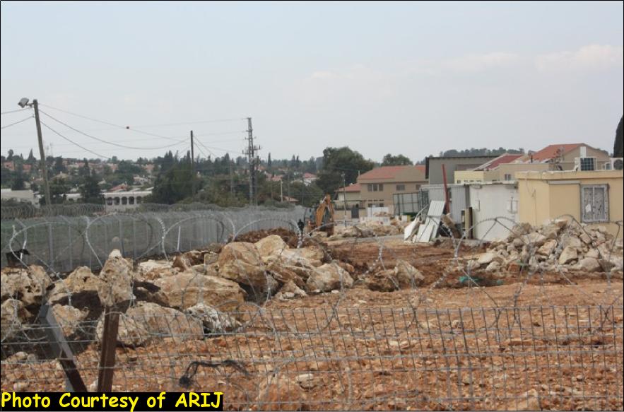
According to the latest revised route of the Segregation Wall route issued by the Israeli Ministry of Defense in April, 2007, the 14 km length Segregation Wall will encircle Azzun Al-‘Atma village from all directions and trap it in an enclave where the only access (in & out) of the village will be through an electronic gate opened daily on specific hours. See Photo 1 & Photo 2


Photo 1 & Photo 2: Azzun Al-‘Atma Main Military Gate
Moreover, the Segregation Wall in Azzun Al-‘Atma village will result in the isolation of 9,650 dunums (73%) from Azzun Al-‘Atma, Beit Amin and Sniriya (Sniriya cluster). Moreover, the Israeli occupation Army issued two military orders holding numbers (78/06/T) and (14/07/T) in the years 2006 and 2007 confiscating 405.5 dunums from Sniriya cluster for building the Segregation Wall. See Map 1:
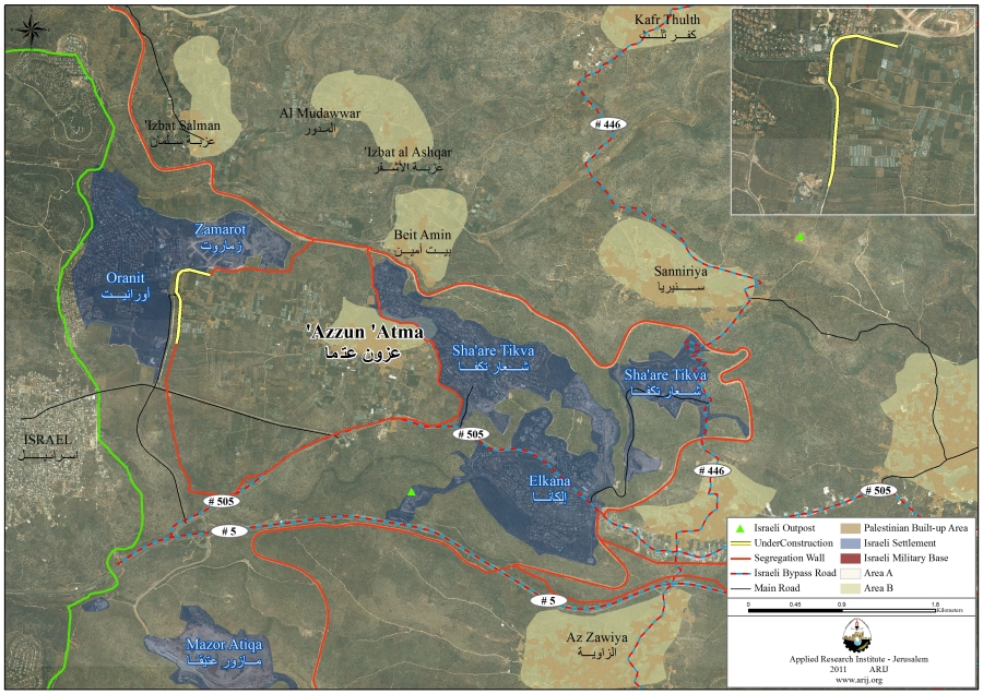
Map 1: the Israeli Segregation Wall in Azzun Al-‘Atma village – Sniriya Cluster
|
Table 1: Illegal Israeli settlements built inside Saniryia Village Boundary
|
||||
|
Settlement
Name |
Establishment Date
|
Pop 2009
|
Total Settlement. Area
(dunums) |
Area of settlement inside Saniryia Cluster- (Dunum)
|
|
Sh’are Tikva
|
1982
|
4084
|
1063
|
755
|
|
Elkana
|
1977
|
3219
|
1515
|
77
|
|
Etz Ephraim
|
1985
|
716
|
566
|
165
|
|
Zamaroti
|
1985
|
Combined Pop. with Oranit
|
310
|
289
|
|
Oranit
|
1983
|
6328
|
1289
|
1038
|
|
Total
|
*****
|
14347
|
4743
|
2324
|
|
Source: ARIJ Database 2011
|
||||
The Geopolitical status of Azzun Al-‘Atma/Sniriya Cluster lands
| Table 1: Classification of Saniryia Cluster. Lands According to Oslo II Interim Agreementof 1995 | ||
| Land Classification | Area-Dunums | %from the totalTown lands |
| Area A | 0 | 0 |
| Area B | 1,441 | 11 |
| Area C | 11,829 | 89 |
| Total | 13,270 | 100 |
| Source: TheGeo-informatics Department – ARIJ 2011 | ||


-
The ICJ Advisory Opinion on the Legal Consequences of the Construction of a Wall in the Occupied Palestinian Territory in July 9, 2004. “The Court has reached the conclusion that the construction of the wall by Israel, the occupying power, in the Occupied Palestinian Territory including in and around East Jerusalem and its associated régime, is contrary to international law and has stated the legal consequences that are to be drawn from that illegality”. Also “Israel is under an obligation to make reparation for all damage caused by the construction of the wall in the Occupied Palestinian Territory, including in and around East Jerusalem.”
-
Also Articles 53 &147 of the Fourth Geneva Convention indicated that: Extensive destruction and appropriation of property not justified by military necessity and carried out unlawfully and wantonly. is a grave breach of the Convention.
-
Art. 23 of the Hague Convention of 1907 also provides: In addition to the prohibitions provided by special Conventions, it is especially forbidden to destroy or seize the enemy’s property, unless such destruction or seizure be imperatively demanded by the necessities of war.
-
Under the Universal Declaration of Human Rights Adopted and proclaimed by General Assembly resolution 217 A (III) of, December 10, 1948, Article 17 reads: ‘No one shall be arbitrarily deprived of his property.’ Which means it bans Israel from destroying or confiscating the property of the Palestinians at any case.
-
The Israeli Occupation practices in the occupied Palestinian territory and especially in the city of Jerusalem clearly violate the Palestinian human rights under international law and the fourth Geneva Convention of 1949 systematically, which constitute a crime of apartheid according to the International Convention on the Suppression and Punishment of the Crime of Apartheid (1973) which defines apartheid as: ‘the imposition of various legislative measures on different racial groups while injuring the rights of one. Moreover, the crime of Apartheid comprises a ‘crime against humanity’ and ‘a serious threat to international peace and security’.


