On the 12th of October 2011, the Israeli settlers of Kfar Taphuh settlement razed lands between Iskaka and Yasuf Villages east of Salfit city, and installed 4 new mobile homes in the area and surrounded them with barbed wires. The razed lands are located between the settlements of Kfar Taphuh and Shevut Rachel (Rechalim) and are owned by:
-
Hamdallah Yousef Abu-Hakmeh
-
Daoud Abdl-Qadir Abu-Thahir
-
Abdl-Qadir Ahmad Abu-Hakmeh
-
Ahmad Hries Lami
-
Ahmad Awad Harb
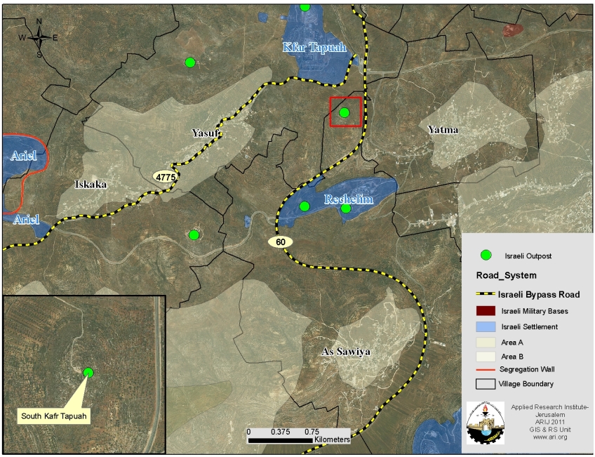
Map 1: the location of the razed lands
It is worth mentioning that the area where the new mobile homes were set up is already occupied by an Israeli outpost under the name of ‘Nofei Nehemia’. The outpost was established in January 2002 and has already around 25 mobile homes which are inhabited by 52 Israeli settlers (PEACENOW 2010). It is worth noting that the outpost is set outside the master plans of both Kfar Taphuh and Shevut Rachel (Rechalim) settlements, which gives a clear indication that there will be a new settlement in the area.
In 1991, Israel announced about master plans for Israeli settlements spread throughout the occupied Palestinian Territory. Those master plans indicated the areas designated for future expansion of Israeli settlements in the oPt; accordingly, the outposts that were established within existing settlements’ master plan constituted new neighborhoods as they helped in enlarging the built-up area of the existing settlements and this of course came on the expanse of Palestinian lands; while outposts that were established outside the master plans of existing Israeli settlements formed buds for new settlements as they occupied new lands and were secretly supported by the different Israeli ministriesto grow; Image 1 & Image 2 &
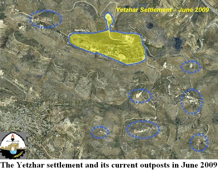
Image 1: Yetzhar settlement in Nablus Governorate and nearby Israeli outposts – June 2009

Image 2: Nearby outposts located within Yetzhar’s settlement master plan
The outpost of Nofei Nehemia is located outside the master plans of both Kfar Taphuh and Shevut Rachel settlements and therefore constitutes a bud for a new settlement in the area to link the aforementioned settlements (kfar Taphuh and Shevut Rachel (Rechalim)) together, at the same time deprive Palestinians of Iskaka and Yasuf their lands.
The outposts and the Israeli Segregation Wall plan in the oPt
The Israeli Segregation wall plan that was published on the Israeli Ministry of Defense website on April 30, 2007 shows that upon wall completion, Israel will annex 60 Israeli outposts (out of 232, total number of outposts in the WB) to its proper in addition to 32 outposts in the Eastern Segregation Zone and 96 Israeli outposts in the Corridors Zone. In total, around 81% of the total number of the Israeli outposts in the Occupied Palestinian territory will be annexed to Israel once Israel completes its plans in the area.
To conclude
It is not by coincidence that Israeli settlers build outposts in the Palestinian territory, but it has always been for a purpose, to grab as much Palestinian lands as possible for the sake of building new settlements and expanding existing ones. The building of outposts comes to fulfill Sharon’s call back in 1998 (when he was still a foreign minister under Binyamin Netanyahu’s Government) to Israeli settlers to capture hilltops and build on them so that they won’t lose them for the Palestinians in future negotiations; he said: ‘Let everyone get a move on and take some hilltops! Whatever we take, will be ours, and whatever we don’t take, will not be ours!
Israeli Settlements under International law
Israel’s colonization of the Occupied Palestinian Territory (OPT) violates numerous United Nations Security Council and General Assembly Resolutions, primarily UN Security Council Resolution 242 (1967) which calls for ‘the withdrawal of all Israeli armed forces from the territories occupied’ in the 1967 war. UNSC 242 effectively outlaws Israel’s occupation of the West Bank (including East Jerusalem) and the Gaza Strip.
The principles of Resolution 242 are reiterated again in Security Council Resolution 452 (1979) which calls upon ‘the Government and people of Israel to cease, on an urgent basis, the establishment, construction and planning of settlements in the Arab territories occupied since 1967, including Jerusalem,’ the Security Council Resolution 446 (1979) which ‘[d]etermines that the policy and practices of Israel in establishing settlements in the Palestinian and other Arab territories occupied since 1967 have no legal validity and constitute a serious obstruction to achieving a comprehensive, just and lasting peace in the Middle East’ and a further time in Security Council Resolution 465 (1980). Israel’s continued refusal to implement these binding resolutions means that it belligerently occupies the OPT.
The Hague Regulations of 1907, contains specific provisions outlawing Israel’s colonization activities. The destruction of Palestinian civilian property and the seizure of Palestinian lands to build Israeli colonies, by-pass roads and the Segregation Wall is explicitly outlawed by Hague Convention IV, Article 23 (G), which clearly states that the occupying power is forbidden “to destroy or seize the enemy’s property, unless such destruction or seizure be imperatively demanded by the necessities of war.”
:::::::::::::::::___
[1] Between the 1949 Armistice Line and the route of the Israeli Segregation Wall
[2] Right after the 1967 war, the Israeli Deputy Prime Minister Yigal Allon suggested to the Israeli Cabinet, that Israel maintains new borders based mainly on controlling the eastern slopes of the West Bank and down towards the Jordan valley, as well as the Western Sahara of the West Bank alongside the Dead Sea shores by building a series of Israeli settlements at an approximate width of 20 Km of the West Bank as a first step towards annexing it to Israel.
[3] The corridors create a geographical link between the western Segregation Zone and the Eastern Segregation Zone.
[4] Sasson Report
Prepared by: