• About The Project
  • Palestine in Century
  • Selected Maps
  • Glossary
  • About ARIJ
  • About LRC
  • By Year
    • Case Studies By Year
    • Daily Report By Year
Friday, May 9, 2025
POICA
No Result
View All Result
  • Home
  • Settlements
    • New Israeli Settlements
    • Settlement Expansion
  • Israeli Violations
    • Agriculture
    • Confiscation
    • Demolition
    • Environment
    • Eviction of Palestinians
    • Settlers Attacks
  • Bypass Roads
  • Israeli Plans
  • Segregation
    • Checkpoints
    • Closure
    • Separation Plans
  • Military Orders
  • Reports
    • Daily Report
    • Monthly Report
    • Quarterly Report
No Result
View All Result
POICA
No Result
View All Result

Beit Ummar: Palestinian Town, continued to get targeted by the Israeli settlers for more land and natural resources grab

August 4, 2011
in Settlers Attacks
On the first of August 2011, Israeli settlers from Karmi Tsor settlement led a survey mission under the protection and guidance of the Israeli Army to the lands of Beit Ummar town north of Hebron governorate. The aim of the survey mission was for the Israeli settlers to identify and locate the water springs and wells in the area, as an initial assessment step to control the water resources located in the surrounding vicinity of their settlement in order to secure additional water resources for Karmi-Tsor settlers.  
 
The targeted surveyed locations of Beit Ummar were Sha’ib-Isyar quarter at the northern part of the town, and Al-Mzir’a and Jala quarters at the western part of the town. The settlers survey mission lasted for 6and half hours during which they pin-pointed many water resources locations that residents-farmers of Beit Ummar use for agricultural purposes and the daily needs. The main point of the operation for the survey was near the house of A’wad Al-Nahas, from which they cross-referenced location marked at the maps they already had and provided for them by the Israeli Civil Administration.
 
The owner of the house and the residents were not allowed to leave their house for the first half an hour when they where scouting the area using military binoculars. Below is an image showing the location of the house of A’wad Al-Nahas used as a command center by the settlers.
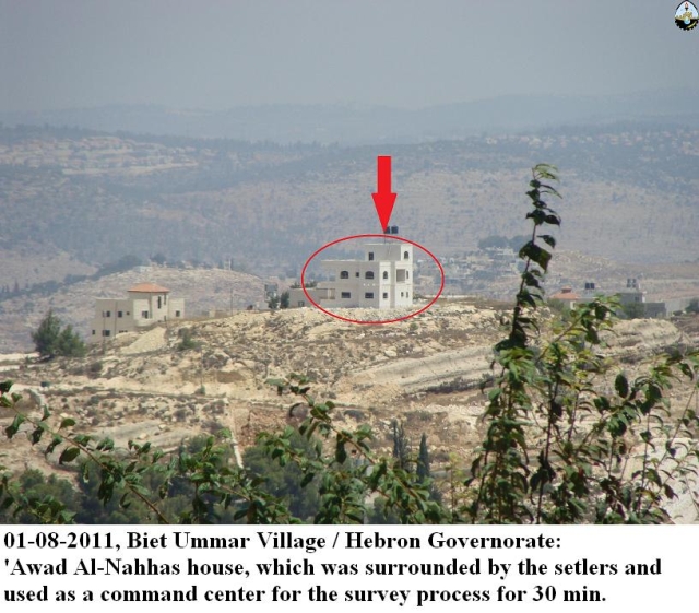
Image 01
 
 The water springs and wells that were surveyed by the Israeli settlers and the Israeli Army are E’in Al-Bwira water spring, Al-Sayeda Najla Water well, and Jala Water spring. Image 02 & Image 03, & Image 04, shows the water springs and wells that were surveyed at their locations.
 
In Jala quarter, the Israeli settlers broke into the Islamic cemetery and made their way to Al-Sayeda Najla Tomb, where they settled performed Jewish religious rituals inside the cemetery.


Image 02                                                            Image 03                                                  Image 04
 
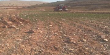
Palestinian residents also testified that while doing the probing for the water resources; the Israeli settlers, and under the protection of the Israeli Army soldier, vandalized the agricultural fields and crops while moving around the cultivated fields that belongs to the Palestinian farmers in the area. The Palestinian farmers on their part attempted to stand up to the Israeli settlers who were armed to stop any further harm to the land and the planted trees. The Israeli settlers on their part; acting under the protection and authority of the Israeli Army responded with shooting few rounds of bullets in the air to scare off the Palestinian farmers; while threatening their life if they (the farmers) continue to stand in their way.   
 
ARIJ field Team met with one of the land owners; Mr. Muhammad ‘Awad, who said that the settlers are aiming to control the area surrounding the settlement; including  all the water resources, wells and springs, in order in preparation to extend the settlements’ jurisdiction further from the current built up area to allow more construction of housing projects to take place in the settlement of Karmi-Tsor.
 
The targeted lands and the water resources there are privately owned lands belonging to Palestinians and used for agricultural purposes or to cope with population growth in the future. The sequences of the Israeli settlers’ plan there are devastating and damaging to the lives of the Palestinians living there; hitting their way of life and their livelihood; and ultimately jeopardizing their sustainability in that area.
 
What is happening on the lands of Beit Ummar is not new, the settlers have attacked the town and terrorized the citizens several times, either by attacking or burning the agricultural fields and damaging their properties and/ or by shooting at civilians or physically assaulting them.
 
About the Israeli Settlement
Karmi Tsor settlement was established in 1984. Its current population is 757 settlers, controlling some 327 dunums of the Palestinians’ lands. Following the Israeli unilateral withdrawal from the Gaza Strip in September 2005, the settlers of Karmi Tsor established an outposts within the settlement’s vicinity to expand the construction area of the settlements, which includes new housing units and synagogue. In Image 05, Image 06, and Image 07 shows the Outpost, established following the 2005 Gaza Unilateral Withdrawal; the watch towers, Synagogue, and new building units.
 
       
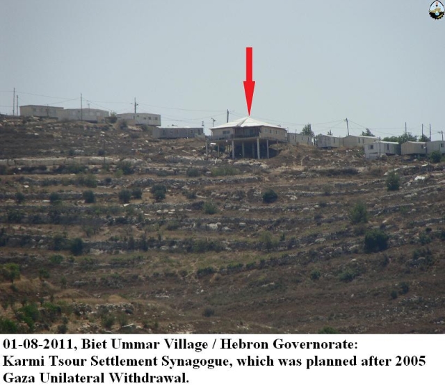
Image 05                                                         Image 06                                                          Image 07
 
Beit Ummar:
Beit Ummar is a Palestinian community – Town, located on the main road between Bethlehem and Hebron Governorates. It is located 10 Km north of Hebron city, and 15 Km south of Bethlehem. It has a total area of 40,150 dunums, of which 32% (13000 dunums) constitutes the built-up area (population exceeding 15000 Palestinians), and 52% (21000 dunums), while some 4000 dunums (10%) were confiscated over different periods of time by the Israeli occupation.
 
 
Prepared by:  
The Applied Research Institute – Jerusalem


Recommended For You

حرب المستوطنين المفتوحة في العام 2024

by arij
February 13, 2025
0
حرب المستوطنين المفتوحة في العام 2024

تشكل اعتداءات المستوطنين الإسرائيليين المتكررة ضد المواطنين الفلسطينيين وممتلكاتهم في الأراضي الفلسطينية المحتلة، بما في ذلك الثروة الزراعية والحيوانية والأراضي والممتلكات، تهديدًا مباشرًا لاستقرار المجتمع الفلسطيني برمته اذ...

Read moreDetails

Deliberate fires Destroy Agricultural Lands in Atuf

by arij
January 28, 2025
0
حرائق متعمدة تفتك بالأراضي الزراعية في عاطوف

  As settler attacks on Palestinian lands escalate, Palestinian farmer Mr. Iyad Bani Odeh from the village of Atuf has fallen victim to yet another assault. Settlers deliberately...

Read moreDetails

حرائق متعمدة تفتك بالأراضي الزراعية في عاطوف

by arij
January 28, 2025
0

الموقع: عاطوف الجهة المعتدية: المستوطنين الجهة المتضررة: السيد اياد مصطفى بني عودة الانتهاك: حرق ارض زراعية مزروعة بمحاصيل حقلية تفاصيل الانتهاك في ظل تصاعد وتيرة الاعتداءات الاستيطانية على الأراضي...

Read moreDetails

انتهاك فاضح للقانون الدولي الإنساني: مستوطنون يصادرون ممتلكات عائلة فلسطينية في عاطوف

by arij
January 23, 2025
0
جريمة جديدة في عاطوف: هدم منزل وحظائر وتشريد عائلة

    الانتهاك: مصادرة ممتلكات الموقع: الرأس الأحمر – عاطوف/محافظة طوباس الجهة المعتدية: المستوطنين الجهة المتضررة: عائلة السيدة دلال بني عودة تفاصيل الانتهاك: تتحول حياة سكان قرية عاطوف...

Read moreDetails

Settlers Confiscate the Property of a Palestinian Family in Atuf

by arij
January 23, 2025
0
A New Crime in Atuf: Home and Barns Demolished, Family Displaced

  The lives of the residents of the Palestinian village of Atuf are turning into an unbearable hell due to the repeated attacks launched by Israeli settlers, as...

Read moreDetails
Next Post

إحراق 20 دونماً في قرية عورتا - محافظة نابلس

LATEST NEWS

الأراضي الفلسطينية بين الذرائع الأمنية والأطماع الاستيطانية – “الأمن، الآثار، والطبيعة كحجج لاقتلاع الفلسطينيين من أراضيهم”

by arij
April 15, 2025
0

........................................................

الطرق الالتفافية الاسرائيلية وأثرها على البيئة الفلسطينية

انتهاك للطبيعة والهوية في الأراضي الفلسطينية المحتلة

by arij
March 17, 2025
0

........................................................

Israel Advances Settlement Plan on Ancient Olive Groves on lands of Beit Jala city, Violating International Law and depriving Palestinians their lands

إسرائيل تمضي قدمًا في مخطط استيطاني جديد على أراضي مدينة بيت جالا، في انتهاك للقانون الدولي وحرمان الفلسطينيين من أراضيهم

by arij
April 29, 2025
0

........................................................

Israel Advances Settlement Plan on Ancient Olive Groves on lands of Beit Jala city, Violating International Law and depriving Palestinians their lands

Israel Advances Settlement Plan on Ancient Olive Groves on lands of Beit Jala city, Violating International Law and depriving Palestinians their lands

by arij
April 29, 2025
0

........................................................

flag_yellow_lowEU-PfP-Logo

This website has been produced with the assistance of the European Union. The contents of this publication are the sole responsibility of ARIJ & LRC and can in no way be taken to reflect the views of the European Union.

© 2025 Copyright ARIJ . All Rights reserved. .

No Result
View All Result
  • Home
  • Settlements
    • New Israeli Settlements
    • Settlement Expansion
  • Israeli Violations
    • Agriculture
    • Confiscation
    • Demolition
    • Environment
    • Eviction of Palestinians
    • Settlers Attacks
  • Bypass Roads
  • Israeli Plans
  • Segregation
    • Checkpoints
    • Closure
    • Separation Plans
  • Military Orders
  • Reports
    • Daily Report
    • Monthly Report
    • Quarterly Report

© 2025 Copyright ARIJ . All Rights reserved. .