On May 30, 2011, the Israeli Civil Administration, operating under the protection of the Israeli Army unleashed dozers to raze lands belong to Palestinians residents of Al-Ma’asara Village, and Al-Khader Village at the southern part of Bethlehem Governorate but the owners of the lands managed to halt the operation after some 10 dunums of grape groves were leveled. This Israeli Civil Administration operation intended to upgrade the road that lead to Efrat settlement exiting from bypass Road 60.
The initial reading for this operation shows that the work is set up new infrastructure grids that include electricity lines, and water supply pipes. Some of the land owners (Adnan Ibrahim Muhammad Salah, Khalil Muhammad Mustafa Salah) indicated to the Field workers of ARIJ when they visited the targeted location that the Israeli Army and settlers have been increasing their number of assaults on their land for sometime now, and this escalation come at the time of the grape harvest season causing sever financial damages to the farmers.
One of the people there indicated that the assault on the land was accompanied by sever vicious attack on the people as well as many has experience life threatening situation as the case of (A.M.S and his son N.A) who were shot at and attempted run over them by a vehicle. The Israeli operation in the targeted location is likely to resume sometime later with reinforcements from the Israeli Army and may very much come to blows between the Palestinian land owners and the Israeli settlers later on.
Other plans maybe in play – a potential neighborhood maybe in sight
It is likely –even though no indication so far- that the new infrastructure set-up is intended for a much bigger plan than the road, which may involve a new neighborhood for Efrat settlement in the entire grape groves in that area, which will end up jeopardizing tens of dunums of Palestinian agricultural land.
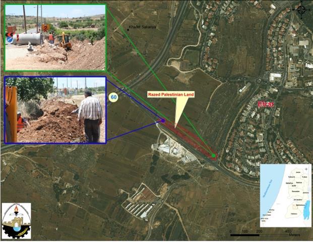
Map 01 shows the targeted lands, and the razing that is held there. The red shaded square shows the targeted lands. The blue frame corner image shows the construction of the electricity lines, while the green frame corner image shows the water and sewage pipelines installation.

MAP 01: Assaults in Al-Khader Village Lands, near by Efrat Settlement
Source: GIS Department / ARIJ 2011
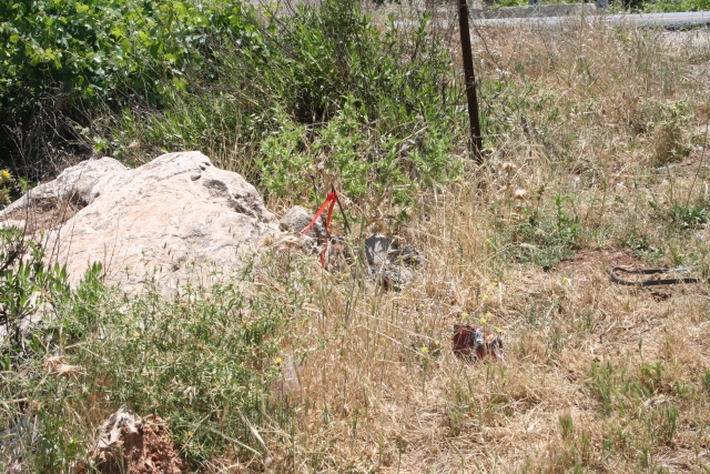
Image 01 and Image 02; shows the markings that identify the work plan.
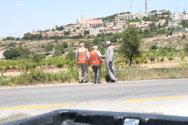
Image 03 and Image 04; shows a Palestinian landowner contesting the Israeli contractors and engineers.


The attempt in progress to snatch much of the Palestinian lands located within the vicinity of Efrat settlement, or any other Israeli settlement for that matter comes within a more comprehensive Israeli plan to snatch as much of the Palestinian land as possible before a some sort of a settlement is forced at a certain point. The Israelis have always adopted “forcing facts on the ground” as their policy to realize the plans.
Al-Khader Village:
Al- Khader village is in the western area of Bethlehem governorate, about 4.5 Km far. It is bordered by Husan and Battir from the northwest and west, and from the east, it is bordered by Bethlehem city, as for the northeast and east, it is bordered by Al-Doha and Beit Jala; as for the south, Artas and Al-Duheisha Refugee Camp is surrounding it from the south.
The Village total land area is 20.090 dunums, 3% of it is the built up area of Al-Khader Village. It is inhabited with 11,666 people, as found by the PCBS 2010, who most of them are farmers, due to the agricultural environment surrounding the village, where fertile and rich soil and lands are found; agricultural is the main source of economic supply and income in this village and area, where if these lands vanish or get confiscated, the source of income will be confiscated too, and starve might occur, and humiliation might be found in the sake to get a source of food or income.
Al-Khader Village is classified into ‘A B C‘ areas, where 565 Dunums are classified as ‘Area A‘, a total area percentage of 2.8 %, holding the highest ratio of Built up Area; as for ‘Area B‘, it represents a total area percentage of 5.9% of the village which is about 1,176 dunums. The Remaining 91.3% percentage of the village total area, or the remaining 18,349 dunums, it is the lands where all the open spaces and agricultural lands, and it is classified as ‘Area C‘, where it is totally under the Israeli control, and a prey for the vicious burglar Settlers attack and assaults.
To conclude out
Israel operations in the occupied Palestinian territory and the Israeli settlers are in violation of the international law, conventions and declarations, and apparently seems to be of no concern to it. Some of the Conventions and Declarations of the International Community Laws are:
-
Paris Protocols of 1954 states: ‘free access for Palestinian goods to the Israeli market and vice versa.’ The curfews and the uprooting are a clear violation of this clear security’.
-
Geneva’s 4th Convention, Article 147 stated: ‘Extensive destruction and appropriation of property not justified by military necessity and carried out unlawfully and wantonly. Is a grave breach of the Convention’.
-
The Hague Convention 1907, Article 23 stated: ‘In addition to the prohibitions provided by special Conventions, it is especially forbidden to destroy or seize the enemy’s property, unless such destruction or seizure be imperatively demanded by the necessities of war’.
-
Universal Declaration of Human Rights, the 10th of December 1948, General Assembly Resolution 217/A/III, Article 17 stated: ‘No one shall be arbitrarily deprived of his property.’ Which means it bans Israel from destroying or confiscating the property of the Palestinians at any case’.
Prepared by:
The Applied Research Institute – Jerusalem
The Applied Research Institute – Jerusalem