In a new confirmatory step by the Israeli Occupation authorities and Army in the Jordan Valley, the Israeli forces demolished structures in two villages in the Northern Valleys, in Tubas Governorate. On the 7th of April 2011, the first demolition wave started, where the Israeli Occupation Army equipped with high numbers of forces, declared the area of Al Aqaba Village in Tubas governorate a Closed Military Area. This declaration is for the purpose of demolition of Palestinian properties located in the Village, where these properties have been alerted in previous months with demolition orders.
The Israeli Occupation Dozers, and under the protection of the Israeli Occupation Army, started from the early morning the demolition on wide ascending scale. The demolition started in the village by various locations as some dozers started the demolition at the western entrance of the village, which connect the Village with the Jordan Valley area.
As for the other divisions, it was distributed in different places in the Eastern section of the village; a division demolished several facilities, including residential homes, animal barracks’s, external restrooms facilities, and external wooden ovens or what is known by Taboun (a traditional cooking feature), a water well with a capacity of 85 cubic meters, bulldozed 23 dunums land farmed with olive tress, and an under construction poultry farm, and two streets east of the village, the first street is Dahyet Al Iskan Street, and Al Salam Street under the pretext of being illegal and not possessing proper authorization from the civil administration being in area C where the Israeli Army is still in control.
It is worth mentioning that 95% of the structures in Al Aqaba Village are under the threat of demolition by the Israeli Occupation Army, under the pretext of illegal construction, being located in Israeli Military Closed Area. In Table I, it shows the demolished and properties and their owners.
|
Table I: Demolished properties in Al Aqaba Village, Tubas / Northern Valleys
|
||||
|
No.
|
Owner
|
Property
|
No. of Properties
|
No. of Family members
|
|
1.
|
Khaled Ahmad Sbieh
|
Residential House
|
1
|
9
|
|
2.
|
Cattle Barracks
|
1
|
–
|
|
|
3.
|
External WC Unit
|
1
|
–
|
|
|
4.
|
Taboon
|
1
|
–
|
|
|
5.
|
Abd Al Naser Ahmad Sbieh
|
Residential House
|
1
|
7
|
|
6.
|
Cattle Barracks
|
1
|
–
|
|
|
7.
|
External WC Unit
|
1
|
–
|
|
|
8.
|
Taboon
|
1
|
–
|
|
|
9.
|
Basem Muhammad Sbieh
|
Residential House
|
1
|
8
|
|
10.
|
Cattle Barracks
|
1
|
–
|
|
|
11.
|
External WC Unit
|
1
|
–
|
|
|
12.
|
Taboon
|
1
|
–
|
|
|
13.
|
Poultry Farm
|
1 (under construction)
|
–
|
|
|
14.
|
Jamal Ibrahim Masa’ied
|
Residential House
|
1
|
15
|
|
15.
|
Cattle Barracks
|
1
|
–
|
|
|
16.
|
External WC Unit
|
1
|
–
|
|
|
17.
|
Taboon
|
1
|
–
|
|
|
18.
|
Water well
|
1 ’85 cubic meter’
|
–
|
|
|
19.
|
Land with Olive Trees
|
23 dunums
|
–
|
|
|
20.
|
Al Salam Street ‘Eastern Side of Village’
|
Street, retaining walls, Electricity Polls
|
1 Km <->, 300 Meters, non specified
|
All village
|
|
21.
|
Dahiet Al Iskan Street ‘Western Side of Village’
|
Street
|
–
|
All Village
|
|
22.
|
Total
|
–
|
18 properties, 2 streets, 23 dunums
|
|
|
Source: ARIJ field Workers � 2011
|
||||
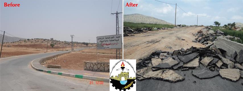
Image 01& 02, show a comparison of the damaged Al Salam street at the eastern entrance of Al Aqaba village. Images 03 ,04 show some of the demolished properties and facilities in Al Aqaba Village in Tubas Governorate.

Image 01
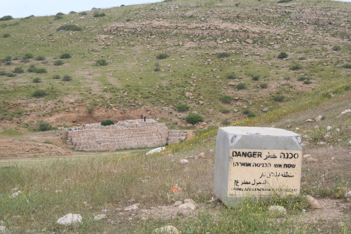
Image 02
Comparison between two images for one street in Al Aqaba village

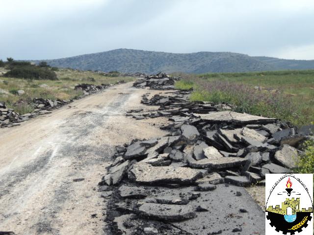
Image 03 Image 04

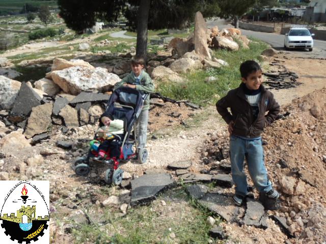
Image 05 Image 06


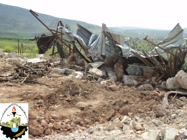
Image 07 Image 08 Image 09
Images of the demolished properties and facilities in Al Aqaba Village in Tubas Governorate
Al Aqaba Village:
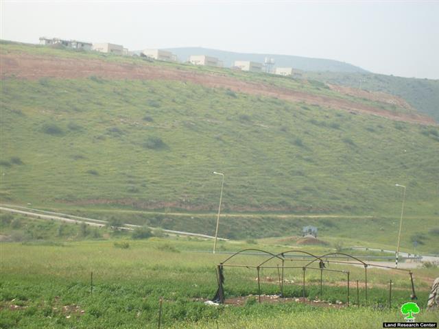
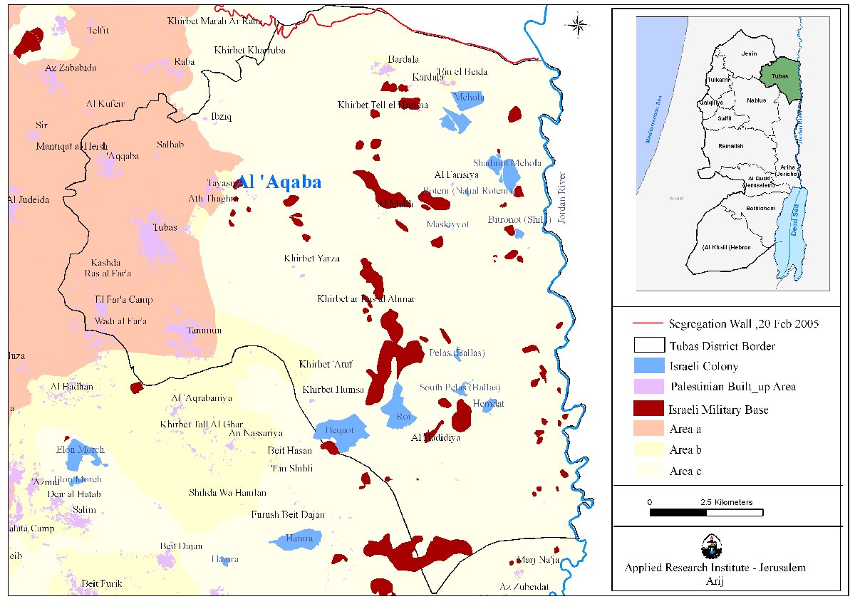
Al Aqabais a Palestinian village in Tubas Governorate located 5 km north east of Tubas city, in the north eastern part of the West Bank. It is bordered by Khirbet Yarza and an Israeli military base (Kopra) to the east, Tayasir village to the west, Ein el Beida and Bardala to the north and Tammun village to the south.
The total area of Al Aqaba village is 2600 dunums, which represents approximately 0.5 % of Tubas Governorate’s land area. 100 dunums 3.9%) constitute the villages built up area, whilst 2500 dunums are agricultural area cultivated with deferent crops; however; some 2000 dunums have been confiscated by Israeli forces and declared as closed military area and used as training and firing range area.
Al Aqaba village is located in a mountainous area. It is surrounded by plains, at the moderate elevation of 298 m above sea level. Al Aqaba village is characterized by a moderate climate. Map 01 & 02, show the village of Al Aqaba.

Map 01
Source: GIS unit / ARIJ 2010
Map 02
Source: GIS unit / ARIJ 2010
Khirbet (Hamlet) Samra
The second wave of demolition, on the 7th of April 2011, led by the Israeli Occupation Army demolished properties and facilities in Khirbet Samra, east of Tubas Governorate. The Israeli Army activities in Khirbet Samra included demolishing of residential houses, cattle barracks, tin shacks, land razing, in addition to harvested and stored agricultural and feeding products.
The demolishing was only ten days later to demolition orders delivered to residents there stating that area is an Israeli Military Closed Area. Table 2 shows the threatened properties on the date of 28th of March 2011, while Image 10 11, and 12, show some of the military orders. Table 3; display the demolished properties and facilities of Khirbet Samra, in Tubas Governorate. Image 13, 14, 15, 16, and 17, show the demolished properties and facilities.
|
Table II: The threatened properties in Khirbet Samra on the 28th of March 2011 in Tubas Governorate
|
|||||
|
No.
|
Owner
|
Properties
|
No. of Property
|
Cattle No.
|
Family Members
|
|
1.
|
Mahyoub Muhammad Abu Amer
|
Residential House
|
1
|
180
|
8
|
|
2.
|
Cattle Barracks
|
1
|
–
|
–
|
|
|
3.
|
Animal Barns
|
2
|
–
|
–
|
|
|
4.
|
Taboon
|
1
|
–
|
–
|
|
|
5.
|
Na’iem Jameel Abu Amer
|
Residential House
|
1
|
100
|
2
|
|
6.
|
Cattle Barracks
|
1
|
–
|
–
|
|
|
7.
|
Animal Barns
|
2
|
–
|
–
|
|
|
8.
|
Taboon
|
1
|
–
|
–
|
|
|
9.
|
Fawzi Abed Abu Amer
|
Residential House
|
2
|
70
|
9
|
|
10.
|
Cattle Barracks
|
1
|
–
|
–
|
|
|
11.
|
Animal Barns
|
2
|
–
|
–
|
|
|
12.
|
Taboon
|
1
|
–
|
–
|
|
|
13.
|
Abed Awad Abu Amer
|
Residential House
|
1
|
130
|
2
|
|
14.
|
Cattle Barracks
|
1
|
–
|
–
|
|
|
15.
|
Animal Barns
|
2
|
–
|
–
|
|
|
16.
|
Taboon
|
1
|
–
|
–
|
|
|
17.
|
Dyab Abed Abu Amer
|
Residential House
|
1
|
120
|
9
|
|
18.
|
Cattle Barracks
|
1
|
–
|
–
|
|
|
19.
|
Animal Barns
|
2
|
–
|
–
|
|
|
20.
|
Taboon
|
1
|
–
|
–
|
|
|
21.
|
Ayman Abed Abu Amer
|
Residential House
|
1
|
120
|
8
|
|
22.
|
Cattle Barracks
|
1
|
–
|
–
|
|
|
23.
|
Animal Barns
|
2
|
–
|
–
|
|
|
24.
|
Taboon
|
1
|
–
|
–
|
|
|
25.
|
Total
|
|
31
|
720
|
38
|
|
Source: Field Workers / ARIJ 2011
|
|||||
Military Orders given to residents of Kherbit Samra

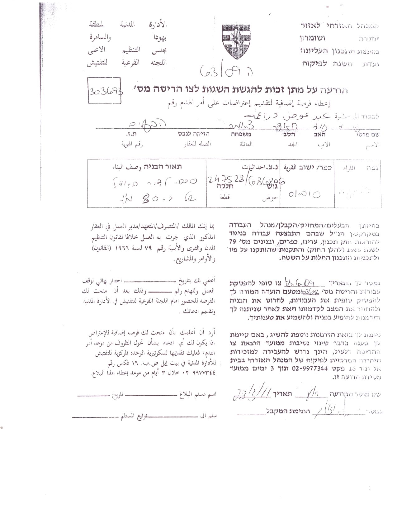
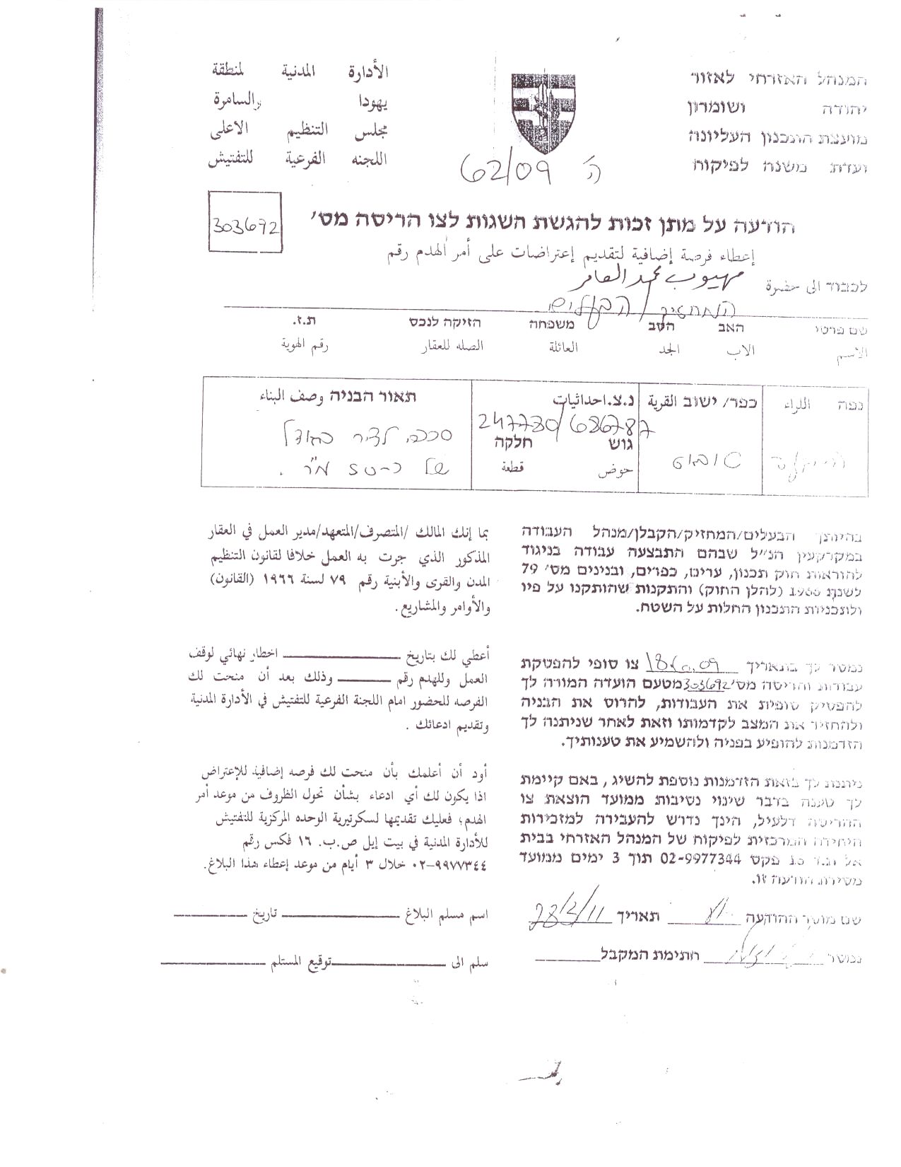
Image 10 Image 11 Image 12
|
Table III: Demolished properties in Khirbet Samra, Tubas / Northern Valleys
|
||||
|
No.
|
Owner
|
Property
|
No. of Properties
|
No. of Family members
|
|
1.
|
Mahyoub Muhammad Abu Amer
|
Residential House
|
1
|
8
|
|
2.
|
Cattle Barracks
|
1
|
–
|
|
|
3.
|
External WC Unit
|
1
|
–
|
|
|
4.
|
Taboon
|
1
|
–
|
|
|
5.
|
Cattle Barn
|
1
|
–
|
|
|
6.
|
Poultry barn
|
1
|
–
|
|
|
7.
|
Na’iem Jameel Abu Amer
|
Cattle Barracks
|
1
|
2
|
|
8.
|
Fawzi Abed Abu Amer
|
Cattle Barracks
|
1
|
9
|
|
9.
|
Cattle Barn
|
1
|
–
|
|
|
10.
|
Tin Shacks
|
1
|
–
|
|
|
11.
|
Abed Awad Abu Amer
|
Cattle Barracks
|
1
|
2
|
|
12.
|
External WC Unit
|
1
|
–
|
|
|
13.
|
Cattle Barn
|
1
|
–
|
|
|
14.
|
Dyab Abed Abu Amer
|
Cattle Barracks
|
1
|
9
|
|
15.
|
External WC Unit
|
1
|
–
|
|
|
16.
|
Taboon
|
1
|
–
|
|
|
17.
|
Cattle Barn
|
1
|
–
|
|
|
18.
|
Tin Shacks
|
1
|
–
|
|
|
19.
|
Ayman Abed Abu Amer
|
Residential House
|
1
|
8
|
|
20.
|
Cattle Barracks
|
1
|
–
|
|
|
21.
|
External WC Unit
|
1
|
–
|
|
|
22.
|
Taboon
|
1
|
–
|
|
|
23.
|
Cattle Barn
|
2
|
–
|
|
|
24.
|
External Kitchen
|
1
|
–
|
|
|
25.
|
Tin Shacks
|
1
|
–
|
|
|
26.
|
Total
|
|
|
38
|
|
Source: ARIJ field Workers � 2011
|
||||
Images of the demolished properties and facilities in Al Aqaba Village in Tubas Governorate:

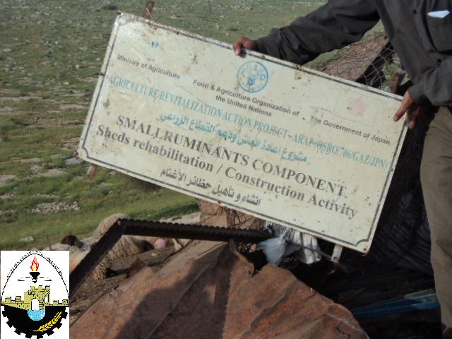
Image 13 Image 14

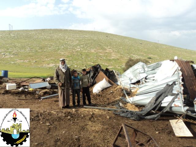
Image 15 Image 16
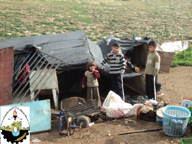
Image 17
Map 03 and 04, shows the geographical location of the targeted hamlet, and Map 05, shows the location of Khirbet Samra with the Israeli military bases surrounding it. Kherbit Samra is trapped within a triangle three Israeli military bases; the first is located east of Kherbit Samra and is called ‘Al Mazoqeh’ and is located on top of Al Mazoqeh Mountain, a strategic area overlooking the northern and southern valleys.
The second military base is located west of Kherbit Samra and is used for military trainings and constitute a continuous threat to the lives of the residents of Kherbit Samra and the surrounding communities. The third military base is called ‘Al Masna’ base’ and is located south of Kherbit Samra.
Map 03
Source: GIS unit / ARIJ 2010
Map 04
Source: GIS unit / ARIJ 2010

Map 05
Source: GIS unit / ARIJ 2010
Israel relentlessness to violate the International Law Conventions has become a trademark of that state of Israel. Some of the main Articles and conventions violated by the Israeli Occupation Army:
-
Geneva 4th Convention 1949, Article 53 &147, which states: ‘any destruction by the Occupying power of real or personal property belonging individually or collectively to private persons, or to the State, or other public authorities or social or cooperative organizations is prohibited, except where such destruction is rendered absolutely necessary by military operations’.
-
Hague Convention 1907, Article 23 states: ‘In addition to the prohibitions provided by special Conventions, it is especially forbidden to destroy or seize the enemy’s property, unless such destruction or seizure be imperatively demanded by the necessities of war’.
-
The Universal Declaration of Human Rights, General Assembly resolution 217, 10th of December 1948, Article 17 states: ‘No one shall be arbitrarily deprived of his property’.
Prepared by
The Applied Research Institute – Jerusalem