
On the 18th of December 2010, the Israeli daily newspaper “Haaretz” revealed that Yoav Mordechai, the former chief of the so-called ‘the Israeli Civil Administration’ issued on the 3rd of November 2010 a military order holding # (10/02/H) to confiscate 50 dunums of lands of Beit Iksa village located northwest of Jerusalem city for the interest of constructing the “Jerusalem-Tel Aviv Rail Line” which, according to the plan, will cut through the West Bank village of Beit Iksa.


Photo 1 & Photo 2: a copy of the Israeli Military order and map that were served to residents of Beit Iksa
Planning for the high-speed train line began late in the nineties. The original route of the rail line was supposed to pass through lands of Israel only, but after a struggle between the Israeli authorities and residents of the adjacent Israeli community (Mevasseret Zion]) who claimed that the route of the train line would destroy the natural views of their community and bring down property prices due to the fact that the train line will be close to the residential area, the Israeli government decided to adopt an alternative route that will cut through the West Bank area, on lands of Beit Iksa village.
The new Israeli train line route will stretch around 6 kilometers inside the West Bank area after being moved 300 meters inside the Green Line (Armistice line of 1949), where accordingly, the high-speed train line would cut the trip between Jerusalem and Tel Aviv to 28 minutes instead of 90 minutes when using the old route. Therefore, in term of travel time, the new proposed train line route through the West Bank area was just more suitable to the Israelis than the old route. Residents of Beit Iksa village however will not benefit from the train line as it will be for the exclusive Israeli use, completely inaccessible to them. See Photo 3
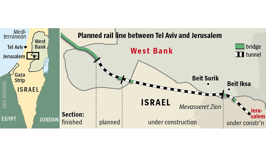
Photo 3: Route of the planned train line
Source: German Rail Under Fire for Controversial Israeli Project
Beit Iksa village, Location & Population
A Palestinian village located about 8 kilometers northwest of Jerusalem city and 10 km south of the city of Ramallah. It has a population of 1825 people. Before the 1948 war, the village spread over an area of 9.1 km2 and its boundaries extended southwards beyond the 1949 Armistice Line (Green Line). During the 1948 war, the village lost 15% of its lands and came to spread over just about 85% (7.7 km2) of its original area. The Palestinian built up area covers only the 3.3% (252 dunums) of the total area of the village, while the majority village lands are forests, open space and agricultural lands.
During the last 4 decades of Israeli occupation, Beit Iksa village witnessed an escalation of violations. Incessant military orders were issued against the proprieties of the inhabitants who faced the loss of their lands and the demolition of their homes for the various Israeli purposes. Consequently, an Israeli settlement was set up on the lands of Beit Iksa village in 1973 which in turn downsized its area to 6.385 km² (6385 dunums) as the settlement today occupies a total land area of 1.349 km² (1349 dunums, 21.1%) of Beit Iksa village.
The Geopolitical Status of Beit Iksa according to Oslo II Signed Agreement
According to the Oslo II Interim Agreement signed in September 1995 between the Palestinian Liberation Organization (PLO) and Israel, the Occupied Palestinian Territory had been classified into Areas “A,” “B” and ‘C,’ designating varying levels of control. Under the signed agreement, Beit Iksa village was fragmented to areas “B” and ‘C.’ where:-
-
Area B constitutes the 7.6% (0.591 km²) of the total area of the village, and includes the urban area.
-
Area C constitutes the remaining 92.4% (7.143 km²) of the village, and includes all the agricultural lands, the forests, open spaces, and all the lands suitable for future expansion. See table 1
|
Table 1: Areas Definition in Oslo II Interim Agreement of September 1995
|
||
|
Area A
|
The Israeli army has pulled out fully and Palestinians hold all responsibilities for internal security and Public order.
|
|
|
Area B
|
Palestinians have full control over the civil administration and Israel continues to have overriding responsibility for security.
|
|
|
Area C
|
The Palestinians have responsibility for civil life such as economics, health, and education; while, Israel retains full control over security and administration related to the territory.
|
|
|
Land Classification
|
Area in Km2
|
%
|
|
Area A
|
0
|
0
|
|
Area B
|
0.591
|
7.6
|
|
Area C
|
7.143
|
92.4
|
|
TOTAL
|
7734
|
100
|
Source: ARIJ GIS UNIT 2010
The Israeli Segregation Wall suffocates 60% of Beit Iksa village
Over the past years, Beit Iksa village was served with many military orders issued by the Israeli Occupation Army to confiscate land for the construction of the Israeli Segregation Wall which commenced in June 2002. According to the updated Wall plan of April 30, 2007, the Wall will surround Beit Iksa village from three directions, east, west and south and will only leave the northern side of the village open for residents of Beit Iksa village to access the nearby neighboring Palestinian villages.
In Total, the Israeli segregation Wall plan will extend for a length of 7 km on the lands of Beit Iksa and will isolate a total sum of 4.601 km² (4601 dunums) of the village’s lands that is around 60% of the total village area which will only be accessible to the landowners through valid Israeli issued permits.
-
Agricultural areas: Up to 1126 dunums, 40% of the total agricultural area of Beit Iksa Village (2822 dunums), will be isolated by the Segregation Wall.
-
Open Spaces and Forests: 2118 dunums, 66.5% of the total area of open spaces and Forests of Beit Iksa Village (3185 dunums) will be segregated by the wall. See table 2 below:
|
Table-2: The impact of the Israeli Segregation Wall on Beit Iksa village Land Use/Land Cover areas
|
||
|
Land Use Land Cover of Beit Iksa Village
|
Total Land Area
|
Isolated Lands by the Wall
|
|
Agricultural Lands
|
2822
|
1126
|
|
Forests & Open Spaces
|
3185
|
2118
|
|
Palestinian built-up area
|
252
|
4
|
|
Israeli Settlement
|
1349
|
1349
|
|
Wall Zone
|
126
|
4
|
|
Total Area
|
7734
|
4601
|
|
Source: ARIJ database- GIS, 2010
|
||
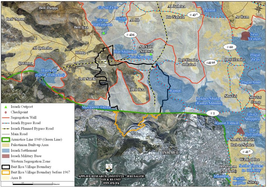
Map 1: The Israeli Segregation Wall plan in Beit Iksa Village
Legal & International Status
The Israeli right-wing government headed by Netanyahu is moving forward in its unilateral colonial plan which aims to eliminating any chance for reaching a just and lasting peace settlement with the Palestinians.
The Israeli military of the Palestinian lands are illegal according to the International law rules and the UNSCR 242 and 338 and accordingly any military ordered issued by the Israeli Occupation Forces is null and void and constitutes a grave breach of the International law rules, agreements and conventions such as:
-
Articles 53 & 147 of the Fourth Geneva Convention of 1949 indicated that: Extensive destruction and appropriation of property not justified by military necessity and carried out unlawfully and wantonly. is a grave breach of the Convention.
-
Also Art. 23 of the Hague Convention of 1907 also provides: In addition to the prohibitions provided by special Conventions, it is especially forbidden to destroy or seize the enemy’s property, unless such destruction or seizure be imperatively demanded by the necessities of war;
-
Moreover under the Universal Declaration of Human Rights Adopted and proclaimed by General Assembly resolution 217 A (III) of, December 10, 1948, Article 17 reads: ‘No one shall be arbitrarily deprived of his property.’ Which means it bans Israel from destroying or confiscating the property of the Palestinians at any case.
::::::::::::::___
[1] Situated inside the 1949 Armistice line (Green Line)
[2] Palestinian Central Bureau of Statistics – PCBS, 2009
Prepared by


