
Whenever an Israeli government spokesman, whether it’s minister of defense or any other official, claims that it took a step which it considers having a political purpose and claiming that it is done to support the economical status of the Palestinians and the encouragement of the Palestinian leadership that believes in peace as a strategic option, the whole world expects a pace that will influence all the Palestinians living in the West Bank, whether they were farmers, employees, students, workers, etc.. However, after the claims have been made, 97% of the road blocks in the West Banks are still in their place and nothing but few minor blocks have been removed. Soon afterwards, the delusion that most people of the world, especially politicians have fallen for becomes clear and the amount of suffering caused by the occupation while the world is amazed by the Israelis ‘peace effort’ become apparent. All the questioned Palestinians agreed on that.
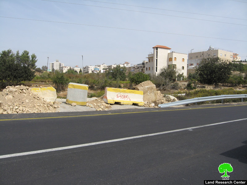
Most of the removed road blocks -19- are located in Hebron district at the both ends of by-pass roads number 60 and 35. The field research staff at LRC and while visiting the removed blockages� sites, they team also inspected, studied, and took pictures for the road blocks that are still placed, taking Hebron as a model of what is happening all around the West Bank.
Road blocks still placed on the edges of by-pass roads 60 and 35 in Hebron District in accordance to position and effect.
|
No.
|
Location
|
Type of road Blockage
|
Nearby army posts or settlements
|
Areas Connected
By road block
From To |
comments
|
|
|
1
|
Al-Tayba, Tarqumia
|
Earth mound
|
Telem settlement
|
Agricultural lands, Tarqumia
|
35
|
Few meters before Telem entrance
|
|
2
|
Al-Tayba, Tarqumia
|
Earth mound
|
Telem settlement
|
Agricultural lands, Tarqumia
|
35
|
Few meters before Telem entrance
|
|
3
|
Al-Tayba, Tarqumia
|
Earth mound
|
Telem and Idura settlements
|
Arid lands
|
35
|
between Telem and Idura
|
|
4
|
Al-Tayba, Tarqumia
|
Earth mound
|
Telem and Idura settlements
|
Arid lands
|
35
|
between Telem and Idura across Blockage number 3
|
|
5
|
Farsh AlHawa
|
Earth mound
|
–
|
Farsh Alhawa
|
35
|
Before Halhoul bridge
|
|
6
|
Hasaka
|
cement blocks and earth mound
|
–
|
Al-Afna
|
35
|
After blockage no. 5 and on the same side, under Halhoul bridge
|
|
7
|
Al-Baqa’a
|
Earth mound
|
Kharsena
|
Al-Baqa’a Agricultural lands
|
60
|
Jaber and Alrajabi are living in tragedy because of the blockage
|
|
8
|
Al-Baqa’a
|
Earth mound
|
Kharsena
|
Al-Baqa’a Agricultural lands
|
60
|
Between Kharsina and Kiryat Arba’a
|
|
9
|
Al-Edesa and Al-Baqa’a
|
large rocks
|
Kharsena
|
Al-Baqa’a Agricultural lands
|
60
|
Between Kharsina and Kiryat Arba’a across blockage no. 8
|
|
10
|
Bani Na’im
|
Earth mound
|
Kiryat Arba’a
|
Al-Jalajel area
|
60
|
the pictures shows the suffering of the people living there
|
|
11
|
Bani Na’im
|
large rocks and earth mound
|
Kiryat Arba’a
|
Bani Na’im
|
60
|
important street that connects Bani Na’im and Wadi Al-Husain in Hebron
|
|
12
|
Qalqas
|
large earth mound
|
Haggai
|
Qalqas
|
60
|
main road leading to Qalqas, there are two earth mounds in the site
|
|
13
|
Qalqas
|
Earth mound
|
Haggai
|
Qalqas
|
60
|
across blockage no. 12, a side road that connects different parts of Qalqas
|
|
14
|
Qalqas
|
Earth mound
|
Haggai
|
Qalqas Agricultural lands
|
60
|
after blockage no. 13, a side road that leads to agricultural sites
|
|
15
|
AlHawooz second entrance
|
cement blocks and iron gate
|
across Haggai
|
Al-Hawooz 2
|
60
|
a vital entrance, two extra earth mounds have been recently added
|
|
16
|
Al-Hijra village
|
large rocks and iron gate
|
Haggai
|
Al-Hijra Village agricultural lands
|
60
|
|
|
17
|
Al-Hijra village entrance
|
cement block and earth mound
|
–
|
Al-Hijra Village agricultural lands
|
60
|
blockage no. 18 is 2 meters away
|
|
18
|
near Al-Hijra Village
|
Earth mound
|
–
|
Al-Hijra southern lands
|
60
|
across blockage no. 17
|
|
19
|
Der Razeh
|
Earth mound
|
–
|
Der Razeh and wad Alshajnah lands
|
60
|
|
|
20
|
Der Razeh
|
Earth mound
|
–
|
Der Razeh and wad Alshajnah lands
|
60
|
|
|
21
|
Abda
|
Earth mound
|
–
|
Abda
|
60
|
Abda Entrance, across blockage no. 22
|
|
22
|
Basm ruins
|
Earth mound
|
–
|
Basm ruins
|
60
|
|
|
23
|
Rabud
|
Earth mound
|
Otene’il
|
Rabud
|
60
|
main road, it takes 20 minutes to get to Hebron by using it. Using the detour takes you about an hour
|
|
24
|
Beit Einoon
|
cement blocks
|
Kharsena
|
Beit Einoon
|
60
|
Across blockage no. 25`
|
|
25
|
Beit Einoon
|
Earth mound
|
Kharsena
|
Ayzon-Hebron
|
60
|
Across blockage no. 24, between them road 60
|


Living Samples:
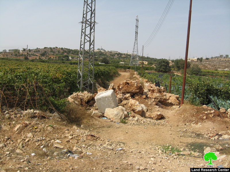
We are going to represent three road blocks from the total of 25 blocks placed on various places on the edges of by-pass roads number 60 and 30 showing the negative effects of the road blocks on Palestinians transportation and economy.
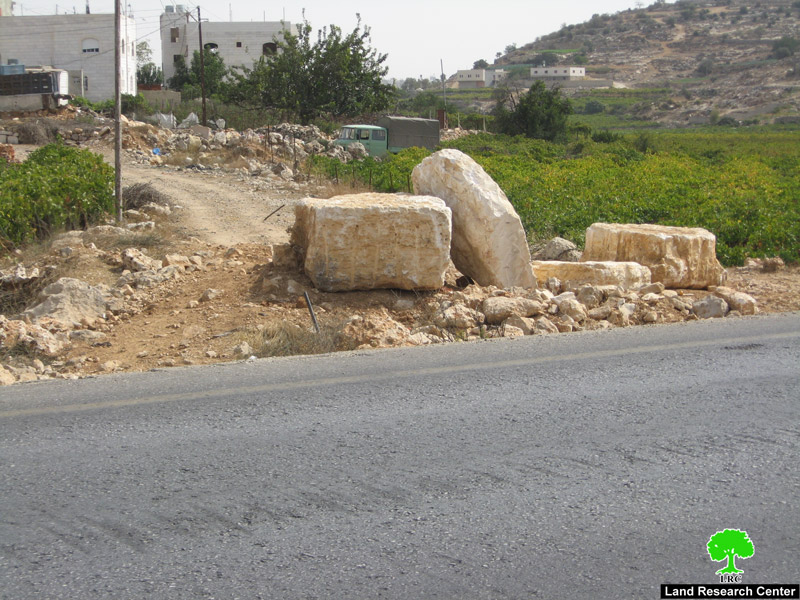
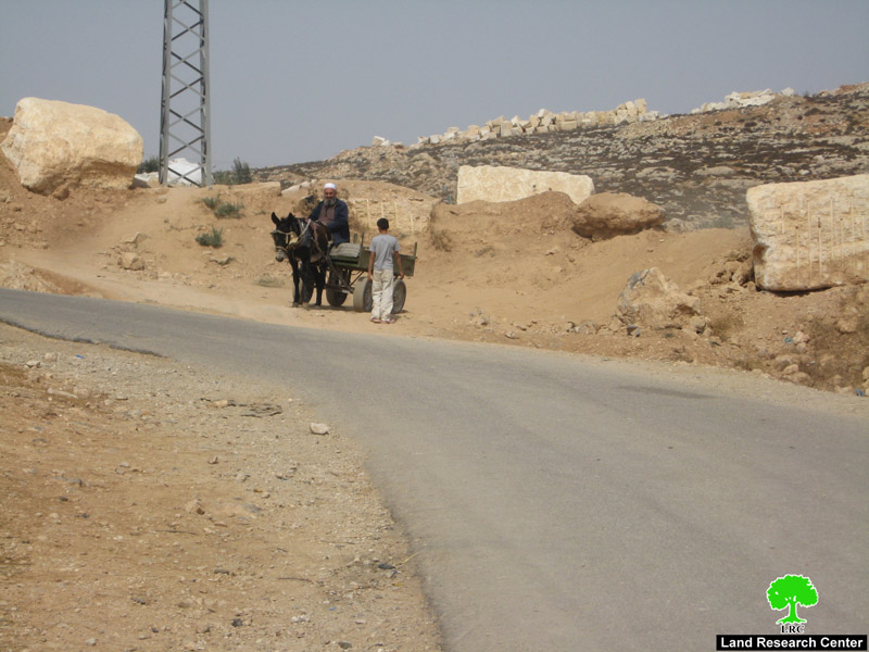
1- Rabud road block’ As Samu’ crossroad’:
It is an earth mound which has been blocking the entrance of Rabud village since 2001. It disconnects a vital road that bonds Adh Dhahiriya town alongside a number of villages near Dura town with Hebron city through by-pass road 60. Because of its closure, residents use alternative paths to reach their destinations, note the blue line in map (1). The shown way is (19km) long, meaning that Palestinians are forced to go extra (9km). The total of 45000 Palestinians suffer from the consequences of this closure.
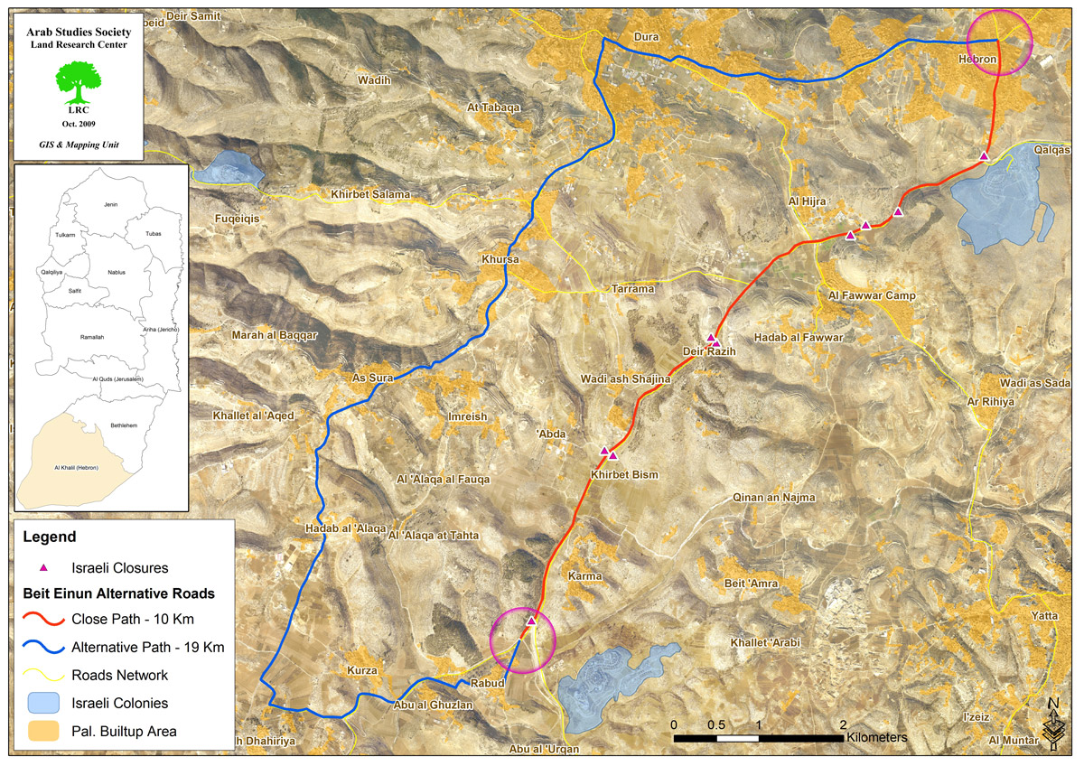
Map (1)

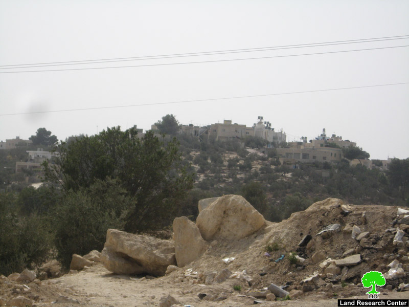
Picture 8+9: the earth mound on Rabud entrance, the picture also shows Rabud village houses.
A female student in Hebron University who lives behind the road block said: ‘ we suffer very much since our house is behind the road block, the distance is much longer. I have to wake up very early in the morning to be at university on time because of the extra kilometers that I have to cross. Nobody cares for usâ��.
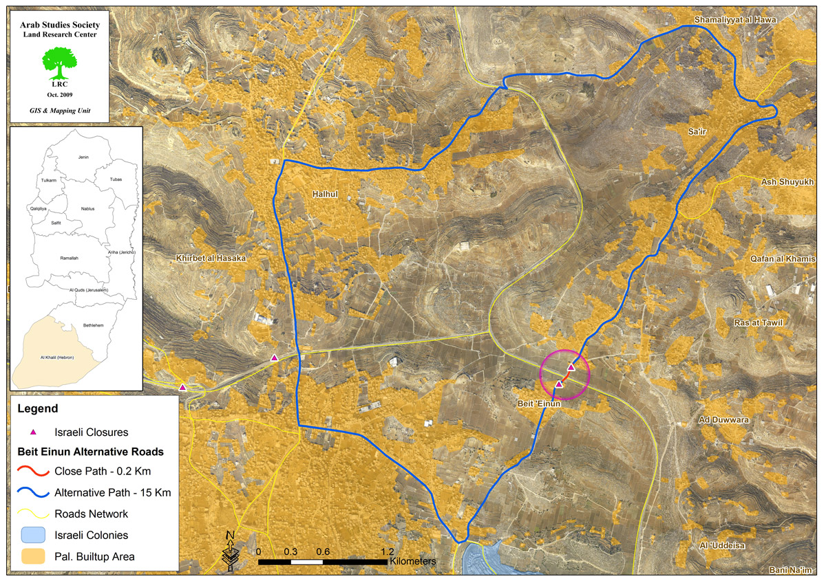
2- Beit Einon road blocks:
It is formed of two road blocks placed opposite each other separated by bypass road number 60. They have been in place for 9 years now. They disconnect the villages of Beit Einon, Al-Edesa, Sa�ir, and Ash Shuyukh in Hebron District through Eizon.
These two road blocks have cut the social, family and work relation ships between the people of Eizon and Beit Einon, on one hand, and between Beit Einon village and its surroundings, on the other hand. The locals had to find a substitute route to get to their target. Instead of walking only 200 meters they have to travel 15000 metes to get to Eizon, which means passing through extra. The total of 31815 Palestinians suffer as a result. Map 2

continuous misery� local people walking through Beit Einon entrance road block.
Getting to school� A death trip.
In order to get to their school, students of Beit Einon have to walk to the road block positioned on the village side, then they have to cross a road that is designed only for Israeli settlers usage and is considered a highway, in other words, it is extremely dangerous to cross it. Next, they have to cross another road block before continuing their way to school. Going to school became hazardous for these children. However, isn’t it more reasonable to eliminate these road blocks instead of removing a non- used road block that leads to nowhere??!!!
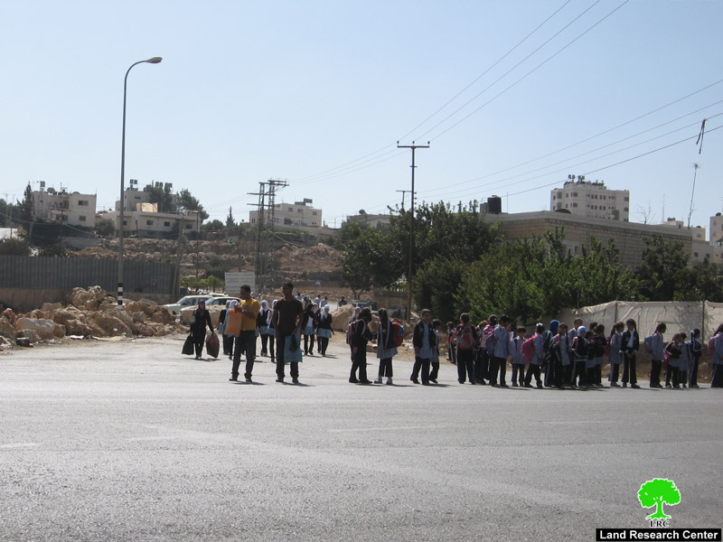
Picture 11: a hazardous trip�students of Beit Einon School on their way to their homes.
3- Khallet Al-Warda block,’Wad Al-Joz’:
It is an earth mound blocking an important road that connects Bani Na’im town with Hebron city. The road is 7km long.
Since its placement, people had to find a 22km long alternative way, an extra 15km. At least 23234 people suffer from the consequences of this road block.
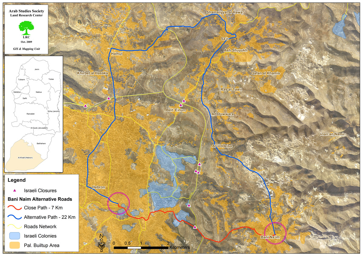
Map (3)
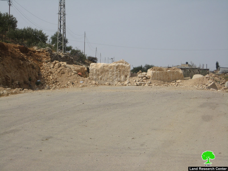
Picture 12: Khallet Al-Warda road block
4- As Samu’ Street
As Samu’- Hebron street which passes through by-pass road number 60 is considered a freeway and does not pass through the residential areas; it is well paved and has a large capacity, however, because of the closure of Al-Hawooz entrance 2 by cement blocks and an iron gate, people have to follow an alternative path that passes through several villages and cities -Yatta, Ar Rihiya, Al Fawwar refugee camp, Dura. Most of the streets in these areas are narrow and need improvements; also they donâ��t have large capacity for traffic, which causes delay and slow movement. It takes the passengers about 1.5 hours to get to their destinations whereas it takes about 15 minutes to get to Hebron using the direct road.
The closed path is (17.5km) long, whereas the substitute is about (19km)long; people have to cross 1.5 extra km, and not to forget the extra time and effort needed to get to Hebron using the narrow and crowded streets. Not less than 21000 people suffer as a result.

map (4)

picture 13: Al-Hawooz entrance 2 closed since the beginning of the Intifada
What next?
The placement of road blocks and the imposed closure policies are considered illegal and illegitimate by all humanitarian and international laws. Also, it contradicts with the Geneva Convention. The occupation authorities justify their actions by using the protection of the settlers who illegally live in this area as an excuse. The occupation authorities granted safety and prosperity for people living outside their lands by taking away the dignity of the residents and owners of the land. Moreover, the settlements roads were used and are still used to separate and divide the Palestinian residential areas.
The Land Research Center strongly condemns the continuous closure of the roads and entrances to Palestinian cities. It also warns from the continuous collective punishment policies held by the occupation authorities without a clear reason. LRC demand immediate removal of the entire road blocks and checkpoints spreading all around the West Bank. It also calls upon the international community and world leaders, especially the European Union, to take immediate actions to force the occupation authorities to remove those 600 road blocks.
Prepared by:
The Land Research Center
LRC
The Land Research Center
LRC


