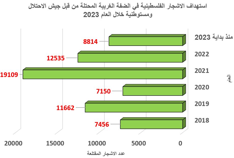
Violation: Cutting of 160 olive trees (Al Nabali type) of the age 20-35 years old.
Location: The southeastern part of the village of Burin – Khallet Siwar region
Violators: The colonists of Yitzhar colony.
Date: 29th of September, 2009.
The following table lists the names of Palestinian landowners affected by the attack and the number of destroyed trees.
|
Name
|
No. of Cutoff Trees
|
|
Heirs of Mr. Abdel Qader Asa’ad Imran
|
95
|
|
Abdel Mu’ein Musa Abdel Aziz Awad
|
20
|
|
Ahmad Mohammad Yaqoub Awwad
|
45
|
|
TOTAL
|
160
|
The Violation:
The village of Burin is located south of the city of Nablus. Its name has become frequently mentioned in the media on daily basis as a living example of daily attacks by colonists, especially the colonists of Yitzhar, under the supervision and protection of the Israeli occupation forces.


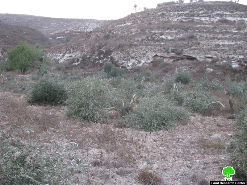
Photos 1+2+3: Olive trees cutoff in the Khallet Siwar – Burin village.
The village saw yet another wave of colonists’ attacks on the 29th of September, 2009, as colonists took advantage of the non-presence of Palestinian farmers in their lands and cutoff and damaged 160 olive trees. The violation took place as the olive harvest season is approaching which is considered to be one of the main sources of income for Burin villagers. The trees were in the region of Khallet Siwar which is located about 2 kilometers southeast of the village and 1 kilometer away from the colony of Yitzhar.
It is worth pointing out that this type of attacks by colonists has been on the increase lately especially during the olive and wheat harvest seasons. Tens of cases of olive tree burning or cutting and even sheep stealing by the colonists have been reported without the presence of anything that deters them from continuing their rampage. That is despite the tens of complaints filed by Palestinian land owners with human rights organizations and official bodies be it from the residents of Burin or other nearby villages such as Iraq Burin, Surrah, Jit, Til, Kafr Qadoom, Fara’atah, Ammatein, Asira Al Qiblia and Madama. These complaints are pointless as the Israeli Police provide the green light (in direct and indirect way) for the colonists to attacks Palestinians and their properties.
Mr. Ali Ahmad Eid, the head of Burin Village Council, indicated the following for the Land Research Center (LRC)’s field researcher: ‘ The Yitzhar colonists are actually armed militias that are very well equipped and supported by the Israeli occupation government. These colonists have been placed here to destroy Palestinian lands and to throw out the Palestinian farmers in order to reach their ultimate goal of taking over the land. We, the residents of Burin and the rest of nearby Palestinian villages and towns, will stand firm in front of these attempts. The colonists will never have their way. We have the right and we won’t give up our lands no matter what.’
It is worth pointing out that 80% of the agricultural lands of the village of Burin is located in the vicinity of the colonies of Brakha and Yitzhar which made them a target to Israeli colonial plans. Such lands have been transferred into “Closed Military Zones” to which Palestinians are not allowed to access only after making necessary arrangement with the so-called “Israeli Civil Administration” during specific times of the year.. That is in addition to the on-going attacks by the colonists on the lands located in Hod Karam Saleem, Hod Al Mayadeen and Khallet Siwar under the watchful eye of the Israeli occupation forces. As such, a large number of attacks have been reported over the past 9 years in the villages of Asira Al Qiblia, Madama and Burin. These attacks included opening fire at Palestinian farmers, raiding Palestinian homes, stealing their farming equipment, cutting off olive trees as well as the daily attacks sustained by 14 Palestinian houses located near the by-pass road which runs parallel to the colony of Yitzhar.
Burin Village:
The village is located 8 kilometers south of the city of Nablus. Its total area is about 10,416 dunums while its build-up area is about 335 dunums. Its population is close to 3500 people. Two colonies were established atop its lands; the colony of Brakha (confiscated 205 dunums) and the colony of Yitzhar (confiscated 150 dunums)
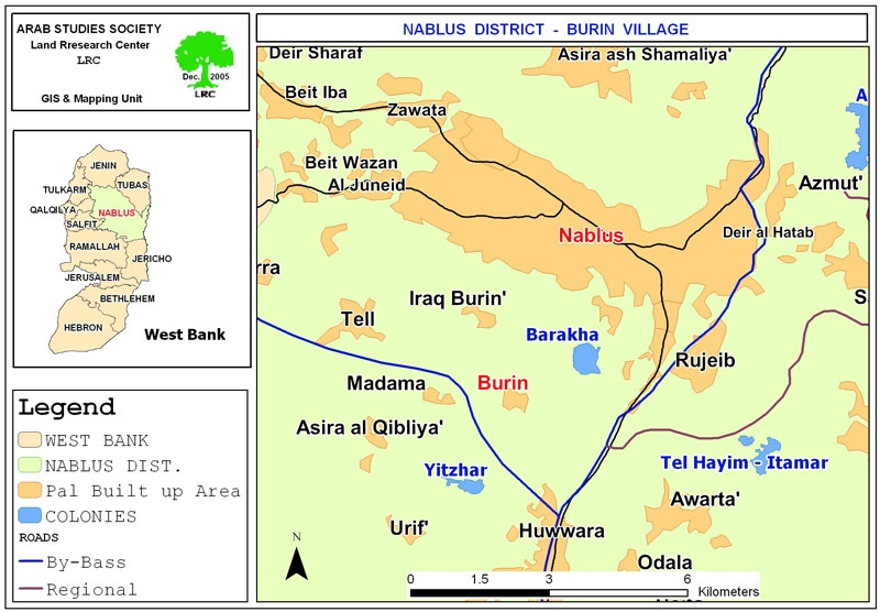
Map 1: The geographical location of Burin village.
The Colony of Yitzhar:
It was established in the year 1983. Its build-up area is 788 dunums in addition to Yitzhar East’s built-up area of 530 dunums. There are 144 colonists live in the colony which was established atop lands from the villages of Burin, Hiwwara, Einabous, Ourif, asira Al Qiblia and Madama.
For more information regarding the Israeli violation against the village of Burin, please refer to the following cases studies as documented by the LRC.
::::::::_
[1] Burin Village Council
[2] GIS Unit at LRC
[3] Ibid.
Prepared by:
The Land Research Center
LRC
The Land Research Center
LRC