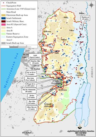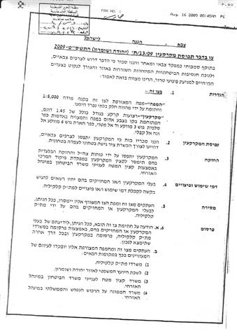
On 15 August, 2009, personnel from the so-called Israeli civil administration in the West Bank accompanied by military jeeps handed over Mr. Khalil Yusif Abu Imran and Mr. Ahmad Othman from Salfit city a military order stating the confiscation of 1 dunum and 400 square meters ( 1 dunum = 1000 M2). The order which carries the number of T/13/09 states that the target land is located in basin 3, Wadi Al Matwi and basin 6, Kifl Haris – Al Wajeh Al Qibli.
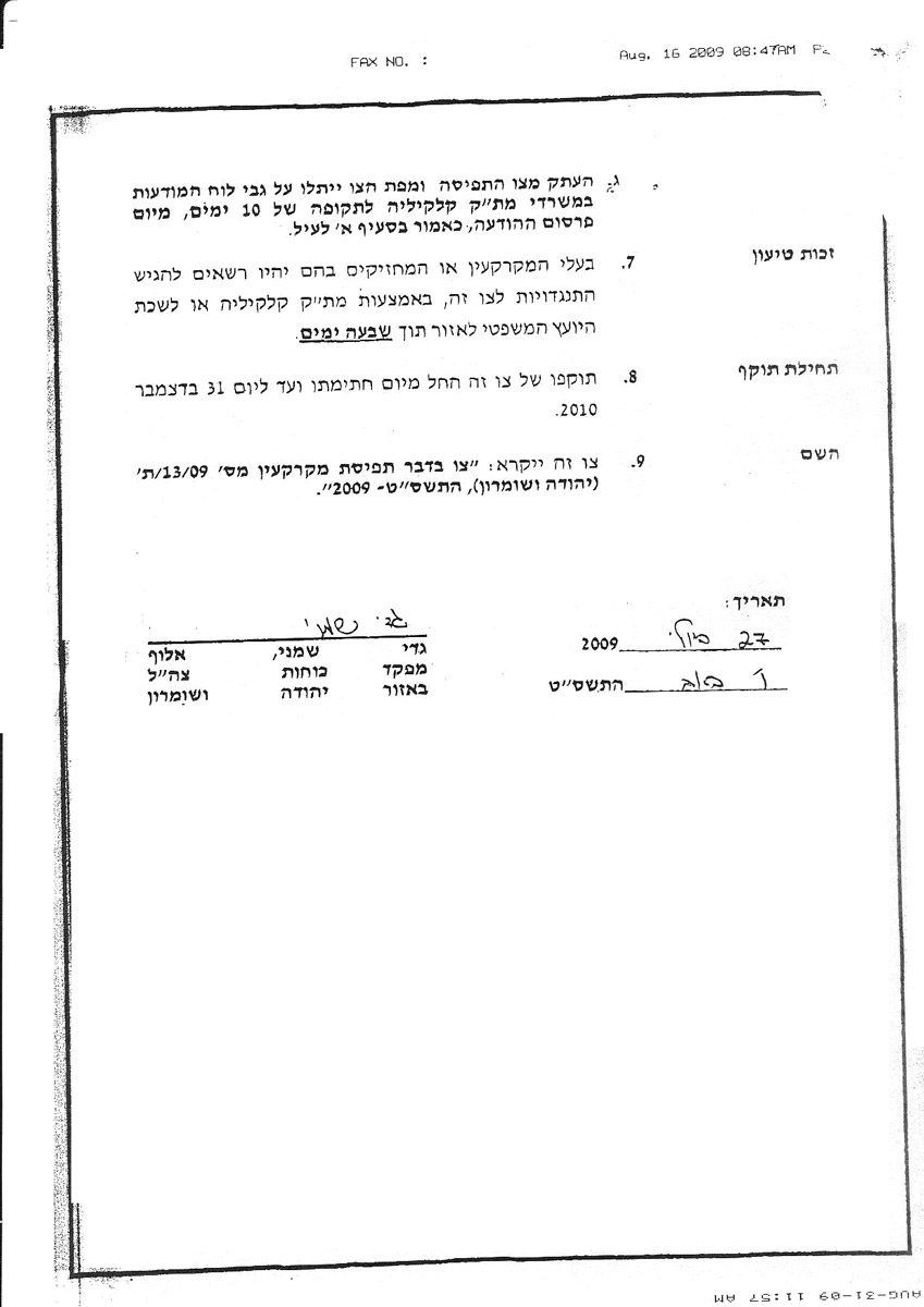

Photo 1: copies of the military order
According to the military order the land was confiscated for the purpose of building a military road to connect between an Israeli military camp and the northern entrance to the city of Salfit. It should be noted here that the northern entrance to Salfit city has been closed since the beginning of the second Intifada in the year 2000. The latest development is a strong proof on the part of the Israeli authorities not to re-open this road which is vital for the city of Salfit and the surrounding areas. In the meanwhile, the Israeli occupation authorities continue to expand the nearby colony of Ariel, the biggest in the West Bank, and build roads around it at the expense of Palestinian owned land. The ongoing expansion and land confiscation schemes aim at developing the colony infrastructure and attracting as much settlers as possible to come and live in the colony.
More agricultural land threatened
It should be noted here that if the aforementioned road is built about a 100 dunums of olive orchards located between bypass road number 505 and the proposed military road will be besieged and, thus, banned for Palestinian access under the pretext of security. By so doing, more Palestinian farmers will be deprived of their main resources of livelihood given that 70% of Salfit citizens mainly depend on olive harvesting as main income.
Impacts of the closure of Salfit city’s entrance
Until the year 2000 the closed northern entrance was the only one leading to Salfit city from the time of the Turks. It was used as a caravan route from south and east Palestine towards the Palestinian cost. During the Jordanian time it was paved and remained the main artery road to the city. Like most towns in the West Bank another alternative roads were opened during the Intifada to link the city with its periphery although not as comfortable as the closed one.
In 1979 the Israeli authorities confiscated Palestinian land in the north of the city to build the Ariel colony. The same road was used by both Palestinians and Israelis and in 1993 it was reconstructed and re-paved by the occupation authorities. Later on it was totally closed by the Israeli army who established a military camp and watch towers close to it.
The following are some of the damage caused by the closure of this road:
1. Economic damage: The city of Salfit has been suffering from the lack of shoppers coming from the surrounding villages which, in turn, aggravates the already bad economic situation in the city. On the other hand, transportation cost in and out of the city has soared to unprecedented levels.
2. The Al Fureiz quarter which is located in the northern suburbs of the city is in bad situation from the economic, security and service point of view due to the existence of the Israeli military camp in its vicinity. People are reluctant to invest in that particular area and this caused a decrease in land prices. The quarter is, also, witnessing a state of reverse migration towards the city center.
3. Social relationships and inter family visits were reduced to the minimum due to movement restrictions and costly transportation.
A glimpse on Salfit city
It is located in the center of the northern West Bank region. It is the capital of Salfit district a with a total population mounting to 8796. The city’s total surface land area is 21724 dunums of which 2200 dunums as built up zone.

Salfit district as a whole is 202,033 dunums in which 59570 citizens who live in 20 locations. The district is considered one of the most fertile areas in the West Bank and the most rich in underground water resources which made it a prime target for Israeli occupation authorities as evident in the large number of Israeli colonies in the Governorate -25- in compare to its small land area. It is most famous for its olive oil production as it used to produce around 3000 tons during the good season and around 700 tons during the bad season in accordance with the statistics of the Palestinian Ministry of Agriculture. Such a production was taking place before 2003, the year when the Segregation Wall was established on the lands of the Governorate.
:::::::::___
[1] GIS unit at LRC
[2] ibid
Prepared by:
The Land Research Center
LRC
The Land Research Center
LRC