This is a question that has long been debated and argued to know what the Israeli state intentions toward the isolated Palestinian lands within the isolated western Segregation Zone (the Palestinians' lands trapped between the route of the Segregation Wall and the 1949 Armistice Line (the Green Line). The Israelis have always claimed that their illegal construction of Walls and fences is for security purposes. On the ground, their actions say otherwise. The isolated Palestinian lands behind the Segregation Wall is 733 km square, and the Land Use / Land Cover analysis of the isolated lands clearly shows that Israel has planned the route of the Wall to make sure they snatch as much possible land from the occupied West bank territory with minimum existence for the Palestinians whom will be squeezed out on voluntarily manner as a result of systematic procedures that aim to push the Palestinians out, such as the checkpoints systems and access through the gates fixed along the route of the Wall to control Palestinian movements in and out of the isolated western Segregation Zone. Table 1 shows the Land Use/ Land Cover analysis of the isolated Palestinian Lands:-
|
Table 1: The Land Use / Land Cover of the Western Segregation Zone (733 Km²) – 13% of the total West Bank Area |
||
|
Item |
Area in Km² |
Percentage of isolated area |
|
Agricultural Areas |
348 |
47.5% |
|
Palestinian Built-up Area |
25 |
3.4% |
|
Israeli Controlled Areas (settlements & Military bases) |
110 |
15% |
|
Forests |
81 |
11% |
|
Open spaces& others |
169 |
23.1% |
|
Total Area of Western Segregation Zone |
733 |
100 |
Source: Applied Research Institute – Jerusalem 2009
Since Israel is yet to mark its eastern borders, apparently what was said by several Israeli politicians with regard to the Israeli Segregation Wall is turning into a reality, another fact on the ground is being enforced by the Israelis and for the Palestinians to accept.
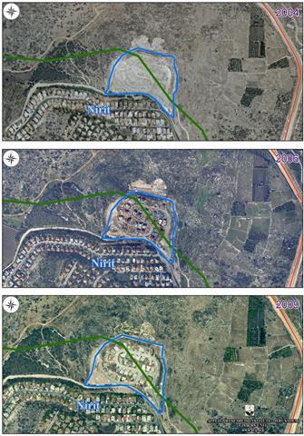
Is Nirit the beginning?
Nirit is an Israeli town located west of the 1949 Armistice Line (Green Line). According to Israeli statistics in 2007, it has a population of 1,100 residents. The town was established in 1981 and was expanded to cope with the population growth in the years 1986, 2000 2004, 2006 and 2009. See Map 1
Map 1: Expansion of Nirit Town over the years
Source: Geo-graphical Information System – ARIJ 2009
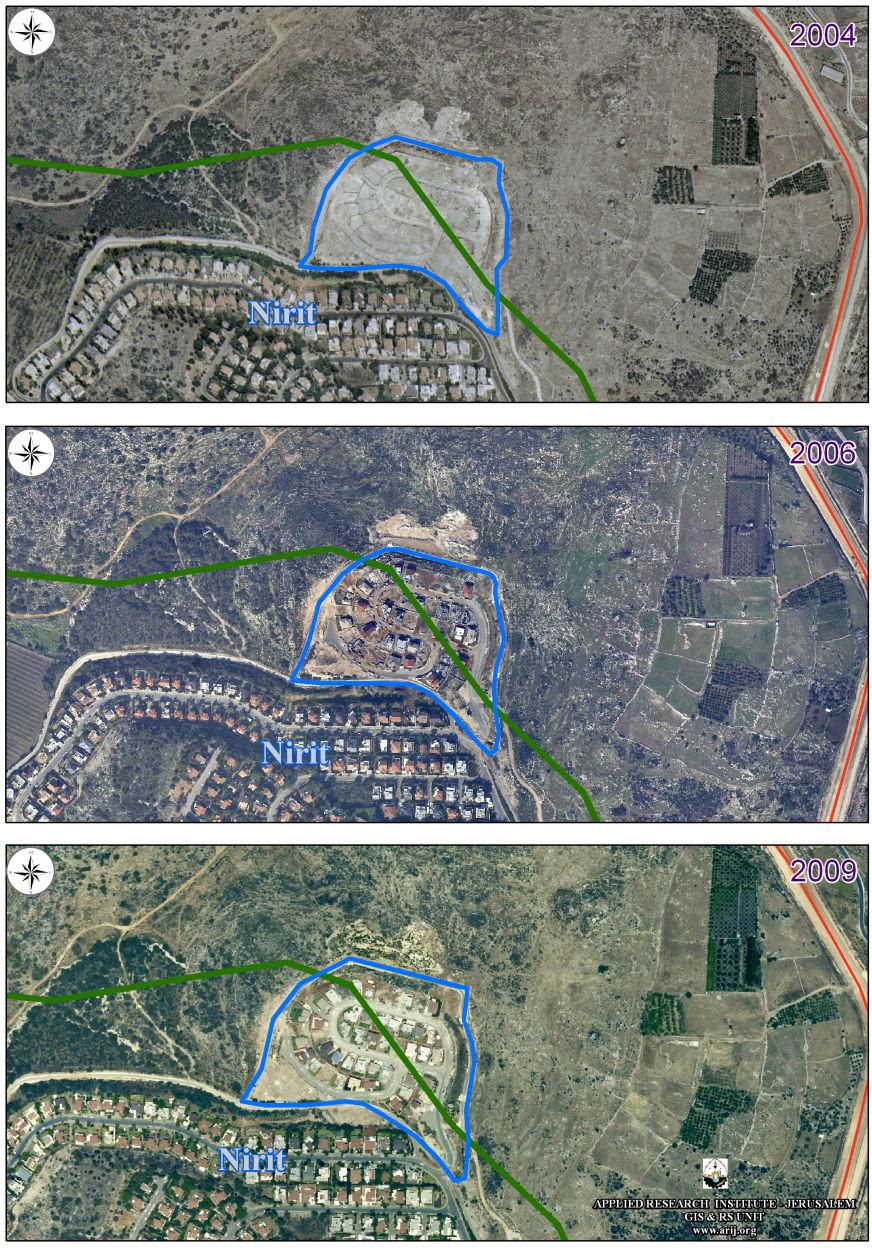
Recently, the Israeli residents of Nirit were surprised by the Israeli Authorities' intention to expand their town inside the West Bank occupied territorial grounds by building a new Neighborhood 'Nof Hasharon' which is to be part of the Illegal West Bank settlement 'Alfe Minishe' located in Qalqilyah Governorate. The Israeli residents of Nirit community refused to become part of the Israeli occupation program and be settlers living in illegal settlement in the occupied Palestinian territory. In fact the Israeli residents of Nirit community seem to be appalled by the notion to be part of the Israeli settlements' program or to be called settlers and thus part of the Israeli occupation. See Map 2

Map 2: The new neighborhood at Nirit Town
Source: Geo-graphical Information System – ARIJ 2009
Accordingly, the residents of Nirit submitted a petition to the Israeli authorities, demanding an immediate halt of any proposed plans to expand their town inside the Palestinian occupied territory. The Petition came as follow:
'We, the undersigned, support the struggle by the residents of Nirit for the immediate cessation of the construction of the new West Bank settlement, 'Nof Hasharon'. 'Nof Hasharon' is really a part of the West-Bank settlement of Alfe-Minishe, a settlement beyond the Green Line. However, Nof Hasharon is to be attached, de facto, to our community, Nirit. We reject this attempt to coerce a small community in Israel, established within the Green Line, into becoming a settlement. We find it inconceivable that while the Israeli government is promoting disengagement in other places, the authorities are approving a hurried procedure for the annexation of a new settlement, in occupied territory, to an existing, long established Israeli village. We demand an immediate halt to the ill-considered construction of this new settlement. 31/1/2005'
Despite of Nirit residents' opposition, the Israeli bulldozers went ahead with the plan and started to lay down the infrastructure for the new community, named 'Nof Hasharon', and lots have been laid for more than 50 new buildings inside the occupied Palestinian territory.
Taking Over the Control of the Isolated Palestinian Lands
The Israeli decision to build the Apartheid Segregation Wall in the occupied Palestinian territories mainly happened to loot as much as possible of the Palestinian lands, and to force a reality that the land area (733,000 dunums) isolated between the Segregation Wall and the Green Line (Armistice Line of 1949) will be used to compliment the Israeli plans to annex the land to be part of the Israeli State. The fact that most of isolated lands are fertile agriculture lands in which their owners cannot reach the lands without unless they acquire special permit from the Israeli Civil Administration.
The Israeli plan to expand Nirit town inside the West Bank and eventually link it with the Israeli settlement Alfe Minishe in the occupied Palestinian territory is an Israeli proactive step to impose facts on the ground, by unilaterally taking control over the Western Segregation Zone (the Palestinian isolated lands located between the Segregation Wall and the 1949 Armistice Line – Green Line). The Palestinians living in side the segregated zone area are spread on just about 3.5% of the total area isolated and the use of their land has became more restricted as the Israeli civil administration forcing new access laws to the isolated areas for extra labor, equipment and in terms of getting the agricultural products out to the main urban centers.
The Palestinians became accustomed to the Israeli breaking the laws and deny them their right to adequate housing, proper living condition, freedom to movement, right to work, freedom to access their holy places among many, which come as a package of their human rights violations in total and indisputable opposition to the International law Rules and conventions:
-
The Forth Geneva Convention states in Article 49 that 'The occupying power shall not deport or transfer parts of its own population into the territories it occupies'.
-
Article 23 of The Hague Convention provides that: 'it forbidden to destroy or seize the enemy's property, 'unless such destruction or seizure be imperatively demanded by the necessities of war'.
-
The ICJ Advisory Opinion on the Legal Consequences of the Construction of a Wall in the Occupied Palestinian Territory in July 9, 2004 indicates that: 'The Court has reached the conclusion that the construction of the wall by Israel, the occupying power, in the Occupied Palestinian Territory including in and around East Jerusalem and its associated regime, is contrary to international law and has stated the legal consequences that are to be drawn from that illegality'.
-
United Nations Security Council Resolutions such as 237 (1967), 271 (1969), 446 (1979), 452 (1979) ,465 (1980 calls on Israel to rescind its previous measures and to desist from taking any action which would result in changing the legal status and geographical nature and materially affecting the demographic composition of the Arab territories occupied since 1967, including Jerusalem and, in particular, not to transfer parts of its own civilian population into the occupied Arab territories'.
Prepared by:
The Applied Research Institute – Jerusalem