To ensure that the village of Nahhalin (southwest of Bethlehem city) not only stops growing but actually decreases in both size and population, Israel has taken many steps throughout the years to make life in the village practically unbearable. To start off, Israel has built eleven Israeli settlements around the Palestinian built-up area of Nahhalin village (in Gush Etzion Area) with six of the settlements at least partly inside Nahhalin village's boundary. See Table 1
|
Table 1: Israeli Settlements in Nahhalin Village Boundary |
||||
|
No. |
Israeli Settlement |
Establishment Date |
Pop 2006 |
Israeli settlement Built-up Area (Dunums) |
| 1 | Geva'ot | 1984 | 55 | 135 |
|
2 |
Betar 'Illit |
1985 |
34700 |
688 |
|
3 |
Rosh Zurim |
1969 |
485 |
889 |
|
4 |
Allon Shevut |
1971 |
3300 |
589 |
|
5 |
Kfar Etzion |
1967 |
570 |
583 |
|
6 |
Bat Ayin (Tzurif) |
1989 |
906 |
104 |
|
|
Total Area |
|
40016 |
2988 |
Source: ARIJ GIS Database – 2009
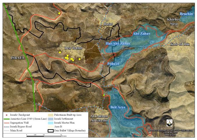
As if the numerous settlements, bypass roads, land confiscations and all the Israeli activities had already taken to provoke the Palestinians and steal their land were not enough, Israel also decided to build the Segregation Wall around to confine Nahhalin along with several other Palestinian communities. The wall, which has been condemned and marked as illegal by the International community, will annex the eleven Israeli settlements comprising the Gush Etzion settlements' bloc to Israel's proper in addition to isolating eight Palestinian communities (Nahhalin Wadi Fukin, Hussan, Battir, Al Walajeh, Al Balluta Hamlet, 'Afaneh Hamlet and Beit Skaria hamlet) in an enclave and separate them form the center of life in Bethlehem governorate and its surroundings.
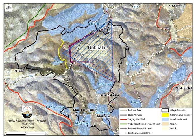
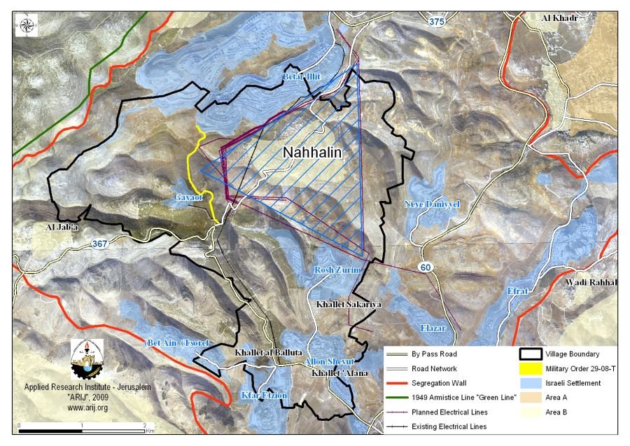
Israel locks Nahhalin in a Triangle Electricity Grid:-
For sufficient electricity to reach the settlements of the Gush Etzion settlement bloc and to cope with future population projections, Israel decided to build a high voltage electricity Grid. However, the Grid is to be built around the Palestinian built-up area of Nahhalin village, further enclosing the Palestinians within the grids lines. The electricity lines will only leave the Palestinians with few thousand dunums of the original 17,250 dunums that forms Nahhalin. In addition to the electricity lines will serve as a border of the Palestinian built-up area as it denies Palestinians further expansion to their current Palestinian built-up area. More over, any constructions remotely close to where the electricity lines will be located will be hazardous and life threatening.
In addition to the High Voltage Electricity Grid, the Israeli Occupation has increased the length of the existing network of bypass roads in the vicinity of Gush Etzion settlements' bloc by constructing several new bypass roads to link Israeli settlements toward each other and to the major highway the at leads to Israel. This road network along with the electricity Grid being constructed will form some kind of a geographical boundary on the ground and will cause Nahhalin village to lose more than two-thirds of its lands as the bypass roads along with the electricity grid will represent a border of Separation between Nahhalin villagers' and their agricultural lands, or rather what remains of Nahhalin's land after it was seized for the construction of Israeli settlements or under the pretext of being declared as 'state lands' since 1967 until today.
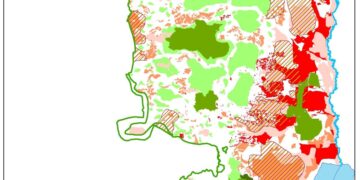
It is worth mentioning that 5.8% (1000 dunums) of Nahhalin's village total land area (17250 dunums) were classified as Area 'B' according to Oslo II Interim Agreement signed between the Israeli Government and the Palestinian Liberation Organization (PLO) in 1995, in which Palestinians have administrative responsibility over civil life such as economics, health, and education; while, Israel retains full control over security and administration related to the territory; the remaining area of Nahhalin village lands which comprises about 94.2% of Nahhalin's village were classified as area 'C' where Israel has full control over this area.
Nahhalin Village, Location & Population
The village boundary of Nahhalin include 17,250 dunums (4 dunums = 1 acre) that includes agricultural land, forests, open spaces, Palestinian built-up area, etc. However, the Palestinian built-up area has been largely increasing in the past few years reaching an all-time high of 496 dunums (ARIJ GIS 2009). See Table 1
|
Table 1: Land Use Land Cover of Nahhalin Village Lands |
|
|
Classification of Nahhalin Village Lands |
Area (Dunums) |
|
Agricultural Lands |
5930 |
|
Forests & Open Spaces |
7522 |
|
Artificial Surfaces |
24 |
|
Palestinian built-up area |
496 |
|
Israeli Settlement |
2988 |
|
Israeli Military Base |
290 |
|
Total Area |
17250 |
Source: ARIJ GIS Database – 2009
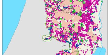
The current population of the Nahhalin village is increasing yet the land available for them to cope with the population growth is getting smaller by the year. A look at the map clearly shows how much land has been illegally confiscated from the Palestinian village of Nahhalin for the various Israeli purposes. This village, as many other Palestinian villages are experiencing the same problem, all of which falls within the Israeli manipulative policies to push the residents to voluntarily move out of their homeland. See MAP 1
- [1] The Hague Regulations expressly forbids an occupying power 'to destroy or seize the enemy's property, unless such destruction or seizure be imperatively demanded by the necessities of war' (Article 23).
- The Fourth Geneva Convention, Article 49.
- Article 53 of the Fourth Geneva Convention is also clear that: 'any destruction by the Occupying Power of real or personal property belonging individually or collectively to private persons, or to the State, or to other public authorities, or to social or cooperative organizations, is prohibited, except where such destruction is rendered absolutely necessary by military operations.'
- The appropriation and destruction of Palestinian land is an especially serious violation of the Fourth Geneva Convention, Article 147 of which clearly prohibits, ''extensive destruction and appropriation of property, not justified by military necessity and carried out unlawfully and wantonly.'' Violations of Articles of the Fourth Geneva Convention constitute grave breaches of the Convention and should be prosecuted as War Crimes.
- Article 49 of the Fourth Geneva Convention relative to the Protection of Civilian Persons in Time of War, August 12, 1949, 6 UST 3516, paragraph 6: The Occupying Power shall not deport or transfer parts of its own civilian population into the territory it occupies.
- Article 46 of the Hague Convention prohibits the confiscation of private property in occupied territory. The confiscation of land by the Israeli government for settlement construction is in violation of this article. (Laws and Customs of War on Land (Hague II); July 29, 1899).
- Article 55 of the Hague Convention stipulates that 'the occupying state shall be regarded only as administrator and usufructuary of public buildings, real estate, forests, and agricultural estates belonging to the hostile State, and situated in the occupied country. It must safeguard the capital of these properties, and administer them in accordance with the rules of usufruct.' In other words, the occupying power cannot take over or use territories or private properties in the occupied territories to serve the interests of its civilian population. (Laws and Customs of War on Land (Hague II); July 29, 1899).
- The Rome Statute of the International Criminal Court (1998) defines 'the transfer directly or indirectly by the Occupying power of parts of its own civilian population into the territory it occupies' as a War Crime indictable by the International Criminal Court. (Article 7, Crimes Against Humanity).
- UN Security Council Resolution 465 of 1980 Determines that all measures taken by Israel to change the physical character, demographic composition, institutional structure or status of the Palestinian and other Arab territories occupied since 1967, including Jerusalem, or any part thereof, have no legal validity and that Israel's policy and practices of settling parts of its population and new immigrants in those territories constitute a flagrant violation of the Fourth Geneva Convention relative to the Protection of Civilian Persons in Time of War and also constitute a serious obstruction to achieving a comprehensive, just and lasting peace in the Middle East.
Prepared by:
The Applied Research Institute – Jerusalem