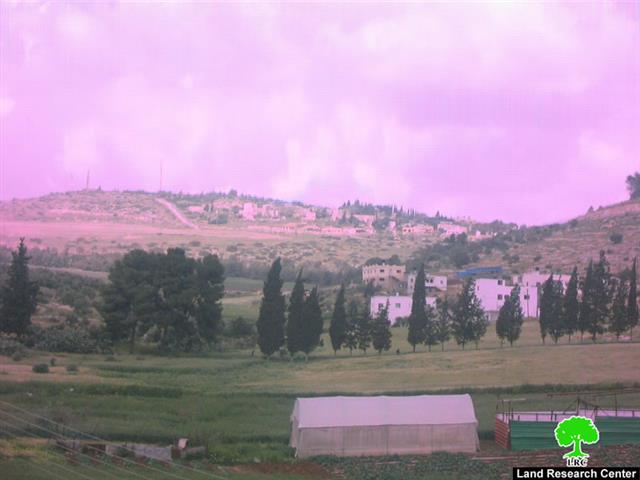
Al Khader Village: Location and Population
The village of Al Khader is located some 4.5 kilometers west of Bethlehem city, with an altitude of 880 meters above sea level. It is bordered by Bethlehem city from the east, Husan and Battir villages from the west and northwest, Al Doha and Beit Jala cities from the north and northeast, and Al Duheisha camp and Artas villages from the south.
The urban area of the village stands on 601 dunums of land, about 3% of the village’s total land area and is a home to 9258 inhabitants (PCBS 2008), most of who tended to work in Agriculture after loosing their jobs as constructional workers inside Israel following the eruption of the second Intifada in September 2000. Today, the village of Al Khader stands on 20090 dunums of land.
Land Classification of Al Khader Village
In the Oslo II Interim Agreement that was signed in September 1995 between the Palestinians and Israelis, the Palestinian areas in the West Bank were classified into three areas A, Band C which aimed at a phased withdrawal of the Israeli military forces from these areas until the accomplishment of a final status agreement.
Accordingly, the 20090 dunums of Al Khader Village were classified to areas A, B and C; 565 Dunums of which were classified as Area A ( 2.8 % of the total village area) where most of the built up area is concentrated; while 1176 dunums (5.9 of the total village area) were classified as Areas B and the remaining area of the village, a total of 18349 dunums of Al Khader village lands were classified as Area C (91.3 % of the total village area) and contain all the agricultural lands and the open spaces in the village. See Table 1
|
Table 1: Classification of Lands in Al Khader village according to Oslo II Agreement of 1995
|
||
|
Classification of Area
|
Area in dunums
|
% of the Village’s total area
|
|
Area A
|
565
|
2.81
|
|
Area B
|
1176
|
5.85
|
|
Area C
|
18349
|
91.3
|
|
Total Area
|
20090
|
100
|
|
Source: ARIJ GIS Unit – 2008
|
||
Al Khader Village Land Classification
Al-Khader village sets in is exceptional high quality and valuable agriculture lands. It is highly cultivated with all sorts if fruitful trees with particular emphasis on the vineyard trees, which the village is mostly famous of. The results of the Land Use Land Cover classification shows that 23 % of the total area of Al Khader village is natural or semi-natural areas (open space and Forests) and Shrub and/or herbaceous vegetations associations); whereas, the agricultural area makes up 59 % of the total village area. The remaining land use land cover classes include the Palestinian urban fabric 3 % and the Israeli Settlements 13.9%. See Table 2
|
Table 2: Land use Land cover 2006 for Al Khader Village Boundary
|
Area in Dunum
|
|
Agricultural Lands
|
11919
|
|
Forests and Open Spaces
|
4574
|
|
Artificial Surfaces
|
146
|
|
Palestinian built-up area
|
601
|
|
Israeli Settlement
|
2791
|
|
Israeli Outpost
|
12
|
|
Wall Zone
|
47
|
|
Total Area
|
20090
|
Source: ARIJ GIS Unit -2007
Agriculture in Al Khader
The fairly abundant sources of clean water next to the rich and fertile soil along with suitable climate has made farming and agriculture feasible in the village and enabled the village to form and produce its own food supply; therefore, agriculture has been and is still considered the major source of income for the residents of the village and plays an important role in its economy; as seen in Table 2.
Even with the good fertile soil in Al Khader village, not all its lands are cultivated and this is due to many reasons; the first of which is the Israeli colonization activities that took place in the village following the 1967 war exemplified in the construction of six Israeli settlements and 1 bypass road on lands of the village. The second reason is largely due to the absence of suitable agriculture roads that provide access to farmers to access their agricultural lands and this is attributed mainly to the fact that most of the agricultural lands are located in area (C) where the Israeli has complete control, which allow them to hinder any efforts by farmers to construct agricultural roads to access their lands with equipment necessary to cultivate it. Thirdly, the Israeli closures that have been and still imposed on the occupied territory, including Al Khader village throughout the years of occupation has immensely obstructed the marketing process of the agricultural products and therefore made farmers less encouraged to utilize their lands fearing of economic loss; and the fourth reason is the scarcity of water quantities available to Palestinians as the Israeli Army dictate the Palestinian share of water to less than minimum, next to the fact that the Israeli Army deny the Palestinian the right to use their natural water resource; in fact, in the year 1999, the Israeli Army has destroyed more than 30 water wells and irrigation pools used by Al Khader farmers for agricultural purposes. Today, the village is mostly dependent on rain-fed farming, water tanks and piped water networks for cultivation.
The Establishment of Israeli Settlement Program in Al Khader Village
Following the 1967 war, the village lost considerable share of its lands (2791 Dunums all agricultural lands) for the establishment of 6 Israeli settlements, Neve Daniel, Alon Shevut, Rosh Tzurim, Efrat and Elazar and Migdal Oz; in addition to the lands that were also confiscated and used for the construction of Bypass Roads to links Israeli settlements with each other (Bypass Road No. 60). Table 3 below lists the Israeli settlements established on lands of Al Khader Village
|
Table 3: Israeli Settlements established on land of Al Khader Village
|
||||
|
Israeli Settlement
|
Establishment
Date
|
Pop 2007
|
Area
(Dunum) |
Location
|
|
Rosh Zurim
|
1969
|
302
|
3
|
West of Al Khader (Bethlehem)
|
|
Allon Shevut
|
1971
|
2960
|
38
|
Southwest of Al Khader (Bethlehem)
|
|
Migdal Oz
|
1977
|
327
|
45
|
South of Al Khader (Bethlehem)
|
|
Neve Daniyyel
|
1982
|
1065
|
583
|
Southwest of Al Khader (Bethlehem)
|
|
Elazar
|
1975
|
870
|
449
|
Southwest of Al Khader (Bethlehem)
|
|
Efrat
|
1979
|
6996
|
1673
|
Southeast of Al Khader (Bethlehem)
|
|
Total Area
|
|
12520
|
2791
|
|
Source: ARIJ GIS Unit – 2008
In addition to the settlements, a total of 5 settlement outposts were also constructed on the lands of Al Khader in the period between 1996 and 2005. Table 4 below details the settlements’ Outposts and their status inside the village boundary. See Table 4:
|
Table 4: Distribution of Israeli Outposts in Al Khader Village
|
|||
|
Closest Mother Settlement
|
No. of Structures
|
Outpost
Name |
Period of Establishment
|
|
Elazar
|
22
|
Derech Ha’avot
|
Feb 2001 – Nov 2002
|
|
Neve Daniyal
|
2
|
Neve Daniyal North
|
Feb 2001 – Nov 2002
|
|
Neve Danyiel
|
12
|
North Neve Danyiel
|
1996- Feb 2001
|
|
Efrat
|
17
|
West Efrat
|
2002 – June 2003
|
|
Neve Danyel
|
3
|
North Neve Danyel
|
June 2003 – Jan 2004
|
Source: ARIJ GIS Unit – 2008
The Segregation Wall eating up Al Khader village lands
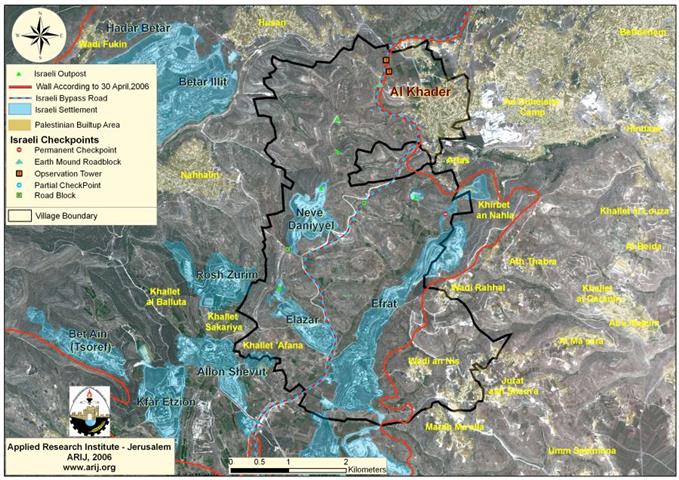
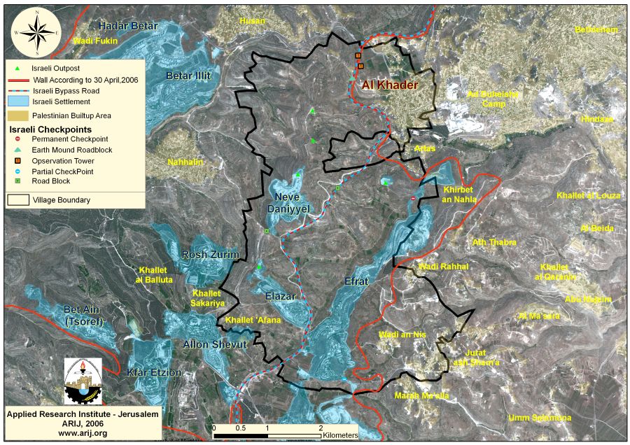
Today, the village of Al Khader as the rest of the Palestinian villages and cities faces the threat of the Segregation Wall. A 6.73 kilometers long section of the Segregation Wall stretching from north to the south is set to cut most of Al Khader village western agricultural lands as thousands of dunums of agricultural lands and open spaces will be isolated behind the Segregation Wall along with the five Israeli settlements established on Al Khader village lands and settlements’ outposts. When completed, the Segregation Wall will end up isolating some 15144 Dunums of land (75.4 % of the village’s total land area) detailed in table 5 below,
Table 5: Classification of Isolated Palestinian Lands in Al Khader Village.
|
Isolated Land use Land cover 2006 for Al Khader Village Boundary
|
Area in Dunum
|
|
Agricultural Lands
|
8874
|
|
Forests and Open Spaces
|
3369
|
|
Artificial Surfaces
|
38
|
|
Palestinian built-up area
|
14
|
|
Israeli Settlement
|
2791
|
|
Israeli Outpost
|
12
|
|
Wall Zone
|
46
|
|
Total Area
|
15144
|
Source: ARIJ GIS Unit – 2008
The Construction of Al Khader Passage
On November 21, 2005, the Israeli Army issued military order # (210/05/T) to confiscate 85 Dunums (according to the order) of lands that belong to three Palestinian communities located west and north of Bethlehem (Beit Jala, Battir and Al-Khader), to construct a tunnel and a terminal for Palestinian traveling between Bethlehem western rural area and Bethlehem governorate. The confiscated lands are located within Block (2) of Al Khader village lands and Blocks 12 and 13 of Battir village lands and Block 2 of Beit Jala city lands. See translation of military order, annex 2.
Currently, the tunnel is undergoing construction process at its designated location under the Israeli controlled bypass road # 60. the starts off west of Al Khader village (east of bypass road #60) and emerges at the other side to the terminal location where the Palestinians had to go through in order to move between the western rural area and the center of the governorate. The new Israeli military order along with the Segregation Wall constitutes a border point between Bethlehem western rural villages (Battir, Husan, Nahalin, Al Jab’a and Wadi Fukin, in addition to the three hamlets ‘Afaneh, Al Balluta and Beit Sakaryia) – population exceeds 22000), and the villages natural extension to the rest of Bethlehem governorate, which will entrap the villages in one big ghetto. See Map 1

Series of Military Orders in Al Khader village for Wall Constructions
In the years between 2001 and 2006, a total of 11 military orders were issued by the Israeli army in relation to Al Khader village for various military purposes (uses), out of which, seven military orders were issued for the construction of the Segregation Wall. Below is a list of the military orders along with their date of issuance and the area they confiscate.
1. Military Order Number 25/01/T was issued on the 29th of August, 2001 and stated the confiscation of an area of land of Al Khader village for military purposes.
2. Military Order Number 93/01 which was issued on the 13th of January, 2005 and stated the confiscation of 7.5 dunums of Al Khader village Lands for the construction of the Segregation Wall.
3. Military Order Number 135/05/T which was issued on the 19 of July, 2005 and stated the confiscation of 448 dunums of Al Khader village Lands for the construction of the Segregation Wall.
4. Military Order Number 157/05/T was issued on the 22 of August, 2005 and stated the confiscation of 21 dunums of Beit Jala and Al Khader lands for expanding The Tunnel’s Road.
5. Military Order Number 18/05/T was issued on the 3ed of October, 2005 and stated the confiscation of 0.4 dunums of Al Khader lands for the construction of an Iron Gate
6. Military Order Number 201/05/T was issued on the 2ed of November, 2005 and stated the confiscation of 94.3 dunums of Al Khader and Beit Jala lands for the construction of the Segregation Wall.
7. Military Order Number 21/99/T was issued on the 8th of August, 2004 and stated the confiscation of 4.7 dunums of Al Khader village lands for the construction of the Segregation Wall.
8. Military Order Number 210/05/T was issued on the 21 of November, 2005 and stated the confiscation of 85 dunums of Al Khader, Battir and Beit Jala lands for the construction of Al Khader Terminal.
9. Military Order Number 24/06/T was issued on the 19th of February, 2006 and stated the confiscation of 170 dunums of Al Khader and Beit Jala lands for the construction of the Segregation Wall and a road along side the wall.
10. Military Order Number 69/06/T was issued on the 25th of July, 2006 and stated the confiscation of 152 dunums of Al Khader, Beit Fajjar and Beit Ummer for the construction of the Segregation Wall and a terminal in um Salamuna area.
11. Military Order Number 77/06/T was issued on the 3ed of September, 2006 and stated the confiscation of 102 dunums of Al Khader and Artas village lands for the construction of the Segregation Wall.
Although Israel has used the pretext of ‘security’ to justify the construction of the Segregation Wall in the West Bank, the Wall’s route has proved to be a land grab tool, nothing more than land theft process, with an aim to incorporate the Israeli settlements and settlers to Israel, thus creating ‘facts on the ground’ and de-facto annexing of Palestinian land, which will have a significant impact on future negotiations regarding borders.
The Israeli Segregation Wall has violated several international treaties and conventions, when it became a tool to restrict the movement of the Palestinians to the isolated areas behind the Segregation Wall under the pretext of security applying accordingly ‘collective punishment’ policy against the Palestinian masses, a procedure that is condemned under the Forth Geneva Convention of 1949.
Furthermore, the lands expropriated for the construction of the Segregation Wall are privately owned by Palestinian, which makes it another procedure stands in violation of the Hague convention of 1907, which forbids the annexation of private property of people under occupation.
The construction of the Segregation Wall also stands in violation of article 147 of the Fourth Geneva Convention that specifically prohibit general destruction and expropriation of property located in occupied territory not justified by military necessity, deeming such destruction and expropriation as a war crime.
Any destruction by the Occupying Power of real or personal property belonging individually or collectively to private persons, or to the State, or to other public authorities, or to social or co-operative organizations, is prohibited, except where such destruction is rendered absolutely necessary by military operations. (Fourth Geneva Convention, Article 53, in conjunction with Article 147).
Anenx 1: Bypass Road # 60: Tunnel Road. Palestinian travel without a permit is forbidden on this road. It connects most of the Gush Etzion Settlements’ bloc and continues north, bypassing the city of Bethlehem and Beit Jala, linking the Etzion bloc to Gilo settlement in the northwest and Har Homa settlement in the northeast.
::::::::::::::__
-
[1] Area A: constitutes the areas where the Israeli army has pulled out fully and Palestinians have complete autonomy over administrative and security issues. Area A, according to the Oslo II agreement, covered the main cities of the West Bank, except for Hebron.
-
[2] Area B: Palestinians have full control over the civil responsibilities and Israel continues to have overriding responsibility for security.
-
[3] Area (C): Palestinians have responsibility for civil life such as economics, health and education; however, Israel retains full control over security and administration related to territory.
Prepared by:
The Applied Research Institute – Jerusalem
ARIJ:
The Applied Research Institute – Jerusalem
ARIJ: