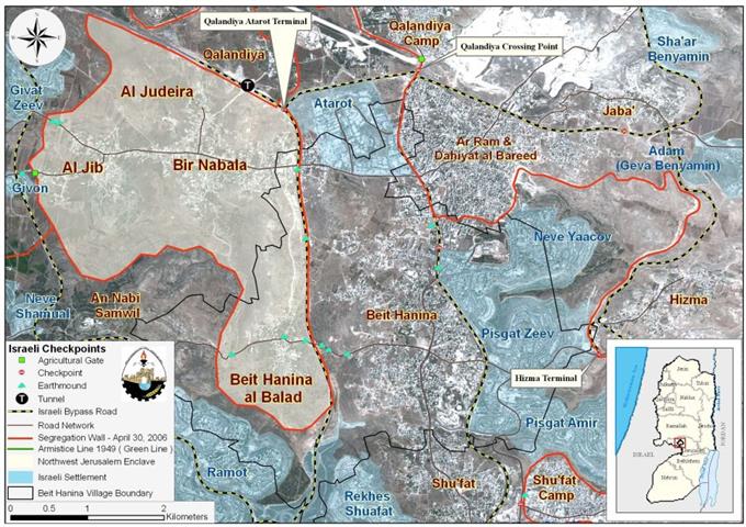
Beit Hanina; a Palestinian town located approximately 5.5 kilometers north of Jerusalem city. It has a mountainous topography with an elevation of 601-800 meters above sea level. It is surrounded by Al-Ram & Dahiyat Al-Bareed from the north, Bir Nabala, Al Judera and An Nabi Samuel villages from the west, shu'fat town and a series of Israeli settlements from the south, and the settlements of Pisgat Ze'ev, Pisgat Amir and Neve Yacoov from the east.
Beit Hanina's total land area is 16284 dunums, out of which, 588 dunums constitutes the built-up area, which is divided into two, Beit Hanina and Beit Hanina Al Balad. The population of Beit Hanina town totals about 3328 inhabitants (PCBS 2007), other than that cultivation makes up a fair share of Beit Hanina's residents livelihood, in addition to being an olive trees basin.
Beit Hanina and Oslo II Agreement
The Oslo II Interim Agreement signed in September 1995 between the Palestinian Liberation Organization (PLO) and Israel, concluded Israel withdrawal from areas of the West Bank, and that the Occupied Territory be classified into Areas “A,”“B” and “C,” designating varying levels of control (see table 1). This jagged distribution has scattered the Occupied Palestinian Territory and turned it into isolated cantons; physically separated from each other.
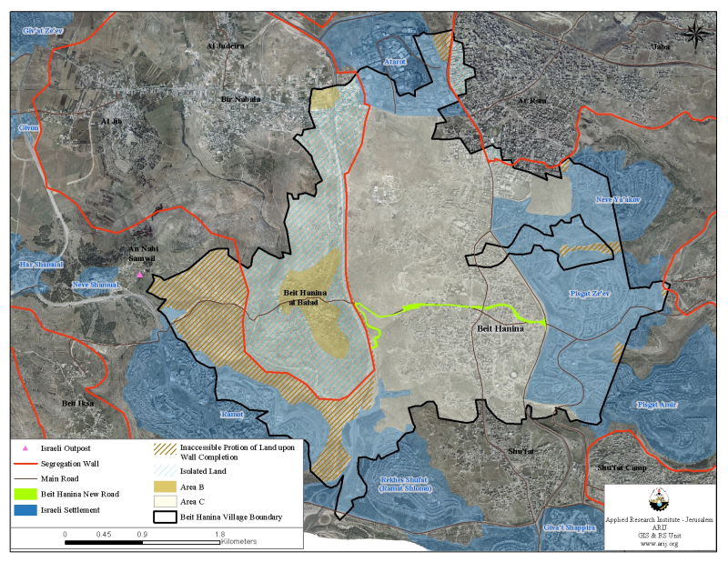
Accordingly, the lands of Beit Hanina town were classified to areas, B and C; but none of the town's area was classified as Area 'A'. A total of 588 dunums were classified as Area B (3.6 % of the total town area) where most of the built up area is concentrated; while the remaining area, a total of 15696 dunums (96.4 % of the total town's area) of Beit Hanina Town Lands were classified as Area C (96.4% of the total town's area) and contain all the agricultural lands, forests and open spaces. See Table 1
|
Table 1: Classification of Lands according to Oslo II Agreement of 1995 |
||
|
Land Classification |
Area |
% of the town's |
|
Area A |
0 |
0.0 |
|
Area B |
588 |
3.6 |
|
Area C |
15696 |
96.4 |
|
Total |
16284 |
100.0 |
Source: ARIJ GIS Database 2008
The Israeli Occupation Practices in Beit Hanina Town
Israeli Settlements in the Palestinian Territory is one of the complicated topics of conflict between the Palestinians and Israelis, and a hindering issue to the peace process. Israel’s activities are based on a systematic plan to construct and build more Israeli settlements as much as possible, in order to inflict facts on the “Palestinian” grounds’ with an intention to break Palestinian geographical contiguity to make the odds of a Palestinian State in the future practically unattainable. Israeli settlement activities in Beit Hanina Town commenced following the 1967 war when Israel captured the Palestinian territory. 'Atarot, the industrial settlement was the first Israeli settlement established on lands of Beit Hanina town, followed by a propagation wave of Israeli settlements in the town. Today, there are 6 Israeli settlements accommodating more than 120,000 Israeli settlers infringed on the Palestinians’ lands in Beit Hanina Town. These settlements are built on a total area of 4555 Dunums (4.6 Km²), which constitutes 28 % of the town's total area. See Table 2
|
Table 2: Israeli settlements built on lands of Beit Hanina Town |
||||
|
Settlements |
Est. |
Total Area – 2006 (dunums) |
Area of settlement inside village Boundary |
Pop. |
|
Atarot |
1970 |
1377 |
513 |
Industrial Settlement |
|
Neve Yacov |
1972 |
1241 |
634 |
22000 |
|
Pisgat Zeev |
1985 |
1546 |
1397 |
41000 |
|
Pisgat Amir |
1985 |
2516 |
879 |
1700 |
|
Ramat Shlomo (Rekhes Shuafat) |
1990 |
1625 |
486 |
14000 |
|
Ramot |
1973 |
3383 |
646 |
42000 |
|
Total |
11687 Dunums |
4555 Dunums |
120700 |
|
Source: ARIJ GIS Database 2008
The Israeli Segregation Wall in Beit Hanina Town
The Segregation Wall has a serving purpose more than the Israeli claims to, the so-called “security” pretext. On the immediate level, it incorporates with the Israeli plan to segregate and take control of nearly 13% of the West Bank’s lands to be annexed to Israel once the Segregation Wall is officially declared as a political border. The Israeli Segregation Wall runs 8.2 Km on Beit Hanina Lands, starting near Atarot Industrial zone in the north, after that it continues southward to Rekhes Shu'fat and Ramot Settlements, piercing through and splitting Beit Hanina Al-Balad (Beit Hanina old town) and Beit Hanina Al-Jadida (new town) literally with physical concrete partitions. At this point, the Segregation Wall runs westward on lands from Al-Nabi Samuel town. See Table 3
|
Table 3: Status of the Israeli Segregation Wall in Beit Hanina Town |
|
|
Wall Phase |
Length |
|
Fence |
0.131 Km |
|
Planned |
6.701 Km |
|
Concrete |
1.359 km |
|
Total Wall Length |
8.191 Km |
Source: ARIJ GIS Database 2008

Upon Completion, the Israeli Segregation Wall will isolate a total of 3102 dunums (3.1 Km²) of Beit Hanina's town total land area which include the open spaces which are designated for future expansion and some agricultural lands that residents of Beit Hanina tended to utilize after losing their jobs as constructional workers inside Israel.
Upon completion also, the Segregation Wall will cause the indirect isolation of an additional portion of Beit Hanina's town lands, a total of 1738 dunums, at its western edge, as land owners will not be able to access it due to its location between the route of the segregation wall and the Israeli settlements of Ramot and Rekhes Shu'fat. This in turn will push people to sacrifice the remaining agricultural lands to accommodate population growth in the coming years. Not forgetting to mention that the population density of Beit Hanina town is estimated at 520 persons per square km. See Table 4
|
Table 4: Lands Isolated from Beit Hanina town due to the construction of the Israeli Segregation Wall |
||
|
Land Classification |
Area (Dunums) |
Lands Isolated from Beit Hanina Town |
|
Agricultural Lands |
2897 |
1183 |
|
Open Spaces and Forests |
5858 |
1744 |
|
Wall Zone |
15 |
0 |
|
Palestinian Built-up Area |
2772 |
417 |
|
Israeli Settlement |
4555 |
15 |
|
Israeli Military Base |
187 |
0 |
|
Total |
16284 |
3359 |
|
In accessible portion of land upon wall completion |
0 |
1738 |
|
Total |
16284 |
5097 |
Source: ARIJ GIS Database 2008
The Israeli Segregation Wall effectively cuts off Beit Hanina Al Balad (Beit Hanina's Old City) from the town’s main urban center. Palestinian residents living in Beit Hanina Al Balad are no longer able to access the town's urban center at their will because the Segregation Wall entraps them along with Beir Nabala, Al Jib and Al Judera villages in one isolated enclave, where the only exit for them is through an alternative road to Ramallah which is 6.5 long and takes one and a half hour time.
Israeli Bypass Roads in Beit Hanina Town
The term 'Bypass Roads' did not come into use until the signing of Oslo agreement between the Israelis and Palestinians in 1993 to indicate designated roads for the Israeli Army and settlers use, to bypass Palestinian towns and communities in the context of the Israeli Army redeployment. From that point on, Israel intensified its efforts to increase the magnitude of the bypass roads in the occupied Palestinian territory as a part of its policy to coerce facts on the ground; ultimately affecting the outcome of negotiation with the Palestinians; including the establishment of a viable contiguous Palestinian State. The majority of the West Bank area is Area 'C', which hold all Israeli settlements and consequently the Israeli bypass roads that pierce at many classified 'A' and 'B' areas establishing a physical obstruction between two controlled Palestinian areas.
The Israeli Bypass Road number 443 dissects the lands of Beit Hanina Town from north to south. It serves Israeli purposes as it links settlements located north of Jerusalem city with each other and with those inside Jerusalem.
A new Israeli bypass Road on lands of Beit Hanina Town
Recently, Israel has started to construct bypass road # 20 which stretches from east to west along parts of Beit Hanina town, splitting the town's urban center into two more sections rather than those caused by the Segregation wall. The Road emerges from Pisgat Ze'ev settlement intersection and consists of two lanes, one for the Palestinians and the other for the Israelis until it connects with Beit Hanina main road. The road then extends 'as one lane' westward, dissecting through the urban area of the town and connects bypass Road number 443 at some point. See Map 1
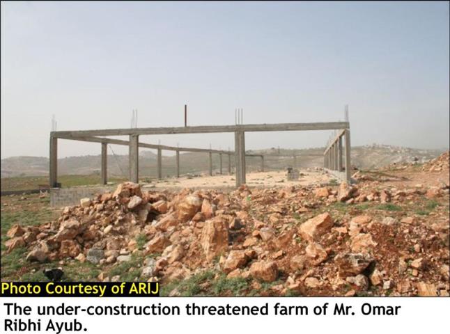
The road will extend for 4 kilometers long and will cause the confiscation of 80 dunums of Palestinian land in the town. The goal behind constructing this new road is to connect Israeli settlements located east of Beit Hanina town with those in the west and inside Jerusalem. In addition, a buffer zone will be constructed on one side of the road where a number of Palestinian houses are situated and are now threatened of demolition.
Demolition of Palestinian houses in Beit Hanina Town
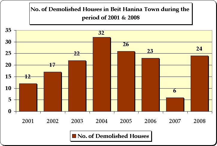
Throughout its ongoing occupation decades, Israel purported demolishing Palestinian houses for various reasons, all of which evolve around 'security needs'. The variation of the Israeli pretext used to demolish Palestinian houses depended on the location of the house to be demolished. Israel always considered occupied East Jerusalem part of unified Jerusalem thus part of the Israeli State, which made the Israeli pretext to demolish houses for security purposes invalid; instead; the Israeli municipality of Jerusalem demolished Palestinian houses in East Jerusalem for build without license. During the period of 2001 & 2007, Israel demolished 138 in Beit Hanina. Israel demolishing of Palestinian houses in East Jerusalem is motivated by Israel's persistence to drive the Palestinian out of the occupied city thus manipulating the demographic balance of Jerusalem. Over the years, Palestinian houses in the occupied territory (including East Jerusalem) were and are still demolished for one of the following reasons:
-
Houses Demolished under the pretext of being built without licenses
-
Houses Demolished under the pretext of 'security needs':
-
Houses Demolished as Collective Punishment
To conclude
Under International law, Israel is illegally constructing the Segregation Wall on Beit Hanina Town and depriving Palestinian residents their full rights in life, of which, right to Freedom of Movement which is protected by Article 12 of the International Covenant on Civil and Political Rights (ICCPR), which states that: 'Everyone lawfully within the territory of a State shall, within that territory, have the right to liberty of movement and freedom to choose his residence.
'Article 3 of the Fourth Geneva Convention of 1949 also strictly prohibits the occupying power from initiating 'violence to life and person' and 'outrages upon personal dignity, in particular humiliating and degrading treatment'.
Settlement construction and expansion in the Occupied Palestinian Territory (OPT) in light of the United Nations Security Council resolutions, international laws, human rights and international covenants Israel's colonization activities violates numerous United Nations Security Council and General Assembly Resolutions, primarily:
-
UN Security Council Resolution 242 (1967): UNSCR Resolution 242 calls for 'the withdrawal of all Israeli armed forces from territories occupied' in the 1967 war.
-
UNSC 242 effectively outlaws Israel's 38 year occupation of the West Bank (including East Jerusalem) and the Gaza Strip.
:::::::::::___
[1] The Israeli army has pulled out fully and Palestinians hold all responsibilities for internal security and Public order.
[2] Palestinians have full control over the civil administration and Israel continues to have overriding responsibility for security.
[3] The Palestinians have responsibility for civil life such as economics, health, and education; while, Israel retains full control over security and administration related to the territory
Prepared by:
The Applied Research Institute – Jerusalem