• About The Project
  • Palestine in Century
  • Selected Maps
  • Glossary
  • About ARIJ
  • About LRC
  • By Year
    • Case Studies By Year
    • Daily Report By Year
Friday, May 9, 2025
POICA
No Result
View All Result
  • Home
  • Settlements
    • New Israeli Settlements
    • Settlement Expansion
  • Israeli Violations
    • Agriculture
    • Confiscation
    • Demolition
    • Environment
    • Eviction of Palestinians
    • Settlers Attacks
  • Bypass Roads
  • Israeli Plans
  • Segregation
    • Checkpoints
    • Closure
    • Separation Plans
  • Military Orders
  • Reports
    • Daily Report
    • Monthly Report
    • Quarterly Report
No Result
View All Result
POICA
No Result
View All Result

The Re-Routing of the Israeli Racist Isolation Wall Devours More Land of Jabara village

December 29, 2008
in Segregation

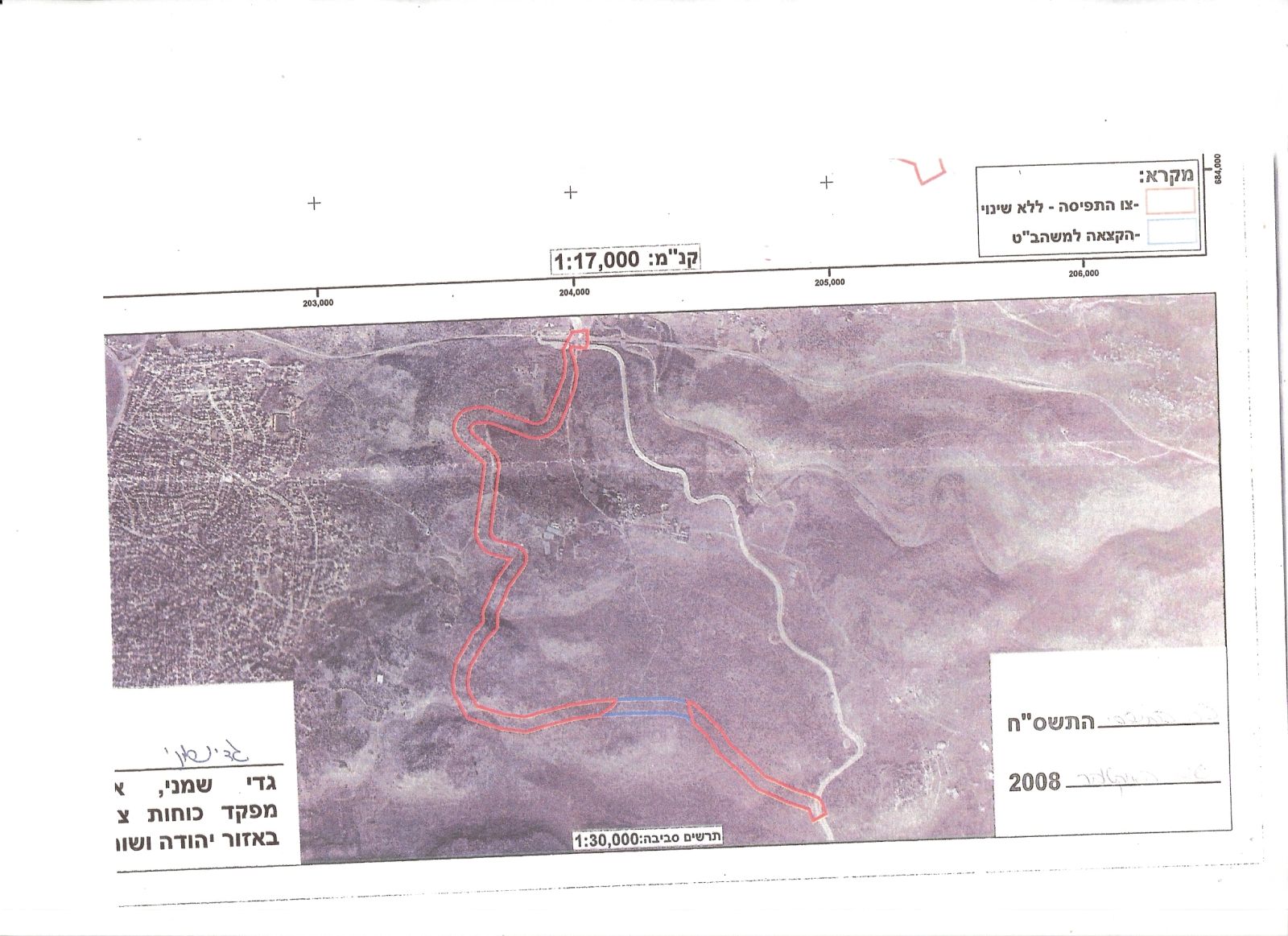
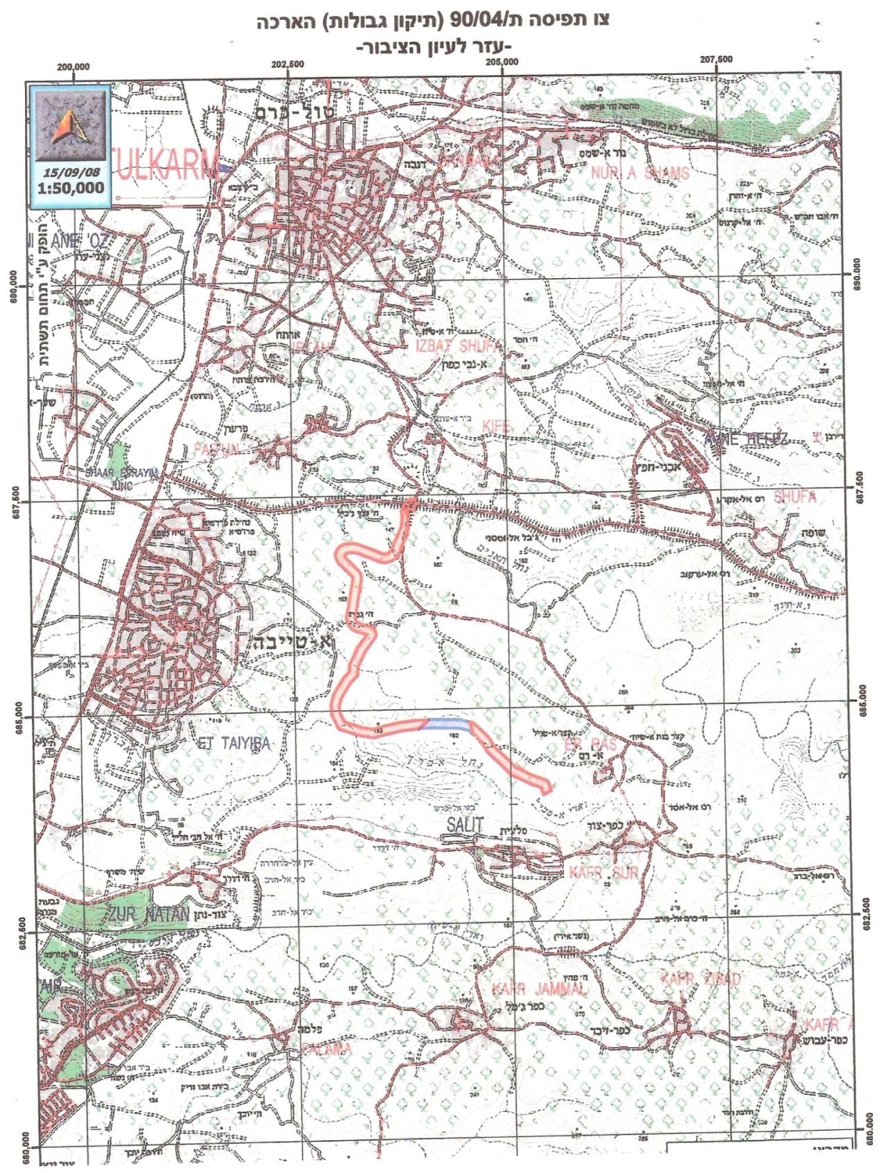
On the 25th of November, 2008 the Israeli occupation army submitted a land confiscation order to the Khirbat Jabara village council in Tulkarem. The order called for the confiscation of 587 dunums and 700 meters for the purpose of establishing a section of the Israeli Racist Wall in the western and northwestern area of the Khirbet. The planned section would effectively isolate the village from the nearby city of Tayba located inside the Green Line.


The new order, holding number T/90/04, reroutes the Wall in parcels Tayba, Al Ras and Far’oun. It is, also, an extension of an earlier order issued in 2007 which called for the re-routing of the Wall. The previous order was issued by the Israeli High Court of Justice after the village of Jabara filed a petition with the Court to remove the Wall. At the time of the filing, the Racist Wall was surrounding the village from all directions which isolated it from its Palestinian heartland. The decision of the Court called for the Wall to be placed only at the western side of the village. In case the new re-routing takes place, hundreds of newly-planted trees will be uprooted.   


The Location:

The village of Khirbet Jabara is located 6 kilometers south of the City of Tulkarem. Its population is about 350 of which 80% came originally from the nearby Al Ras village. The remaining 20% came originally from the village of Far’oun and the City of Tayba located inside the Green Line.


There are four main clans in the village; Jabara, Oudah, Awad and Abu Safiya. Before the year 2002 (before the construction of the Racist Wall) around 95% of its workforce used to depend on agriculture and raising chicken. According to Ministry of Agriculture data, the village had the largest number of chicken farms in Tulkarem with more than 78 chicken farms in which 1 million chic were raised. In addition, the village had around 100 dunums of Green Houses most of its products used to be marketed mainly inside the Green Line and other parts of the West Bank.


It is worth pointing out that 90% of the villages’ lands are registered in the Land Registry in Parcel 2 of the nearby Al Ras village. The remaining 10% are registered as part of the village of Far’oun. In accordance with this classification, the Israeli occupation authorities did not recognize the village for the longest time as an independent village. Up until June 2006 these authorities considered the village as an unrecognized community administered by Al Ras village.


Occupation-Caused Agony to the Village of Jabara:

The agony of the villagers in Jabara started in July 2002 when the Racist Wall surrounded the village from 3 directions; north, east and south which led to its total isolation from its West Bank heartland. The agony manifested itself in the following forms:

  • The destruction of more than 150 dunums atop which the Wall was built. The length of Wall that surrounds the village is about 3 kilometers with a width of 70-80 meters.

  • The construction of the Wall led to the isolation of 350 Palestinians behind it.

  • Marked difficulties in providing the basic services to the residents of the village; medical teams as well as civil society and humanitarian organizations need to have a prior coordination with occupation authorities as to allow them through the 2 Wall gates into the village. It is worth noting here that one of gates (Gate 22) has been closed since June 2006 until nowadays. As for the other gate (Gate 753) it used to operate 3 times a day for one hour each time; between 7:00 and 8:00 AM, between 1:00 and 2:00 PM and between 5:00 and 6:00 PM. As such, the students of the village used to face many difficulties as they were forced to attend Al Ras School due to lack of schools in the village. The need to go back and forth between their village and the school forced the students to wait for long hours under harsh weather conditions for the occupation soldiers to open the gate for them. The situation was unbearable to the degree that the International Committee for the Red Cross (ICRC) placed a tent near the iron gate so that the students can protect themselves from the severe weather conditions the area is known for. When Gate 22 was totally shutdown, Gate 753 was opened 24 hours a day but only for villagers holding IDs with Jabara as a residence place.

  • The agricultural sector was the hardest hit as the Wall caused the total collapse of the chicken farming industry in the village. Hard hit was also the Green Houses industry due to the inability to market the products in neither the Israeli nor West Bank markets. As such, the unemployment rate has drastically increased in the village during the years of the Intifada.  


Prepared by:
The Land Research Center
LRC

Recommended For You

سلطات الاحتلال الإسرائيلي تفرض واقعا جيوسياسيا جديدا في منطقة شمال قطاع غزة المحتل

by arij
March 13, 2024
0
سلطات الاحتلال الإسرائيلي تفرض واقعا جيوسياسيا جديدا في منطقة شمال قطاع غزة المحتل

  أظهرت صور الأقمار الصناعية الصادرة عن برنامج مراقبة الأرض التابع للاتحاد الأوروبي (كوبرنيكوس) لقطاع غزة المحتل في العاشر من شهر اذار من العام 2024، ان سلطات الاحتلال...

Read moreDetails

الحرب على قطاع غزة وتأثيرها على محافظة الخليل جنوب الضفة الغربية

by arij
November 30, 2023
0

  تقع محافظة الخليل في الجزء الجنوبي من الضفة الغربية المحتلة، إلى الجنوب من مدينة القدس، وعلى بعد حوالي 36 كم منها. يحدها من الشمال محافظة بيت لحم،...

Read moreDetails

تطبيق سياسة الفصل العنصري على استخدام الطرق الرئيسية في الضفة الغربية وتقيد حركة وتنقل المواطنين الفلسطينيين

by arij
November 22, 2023
0
معاناة شجرة الزيتون الفلسطينية بسبب الاحتلال والاستيطان في العام 2023

  بناء على تقديرات مراقبين دوليين يبلغ عدد الحواجز الإسرائيلية في الضفة الغربية أكثر من 567 حاجز إسرائيلي متعددة الاشكال منها 77 حاجزًا رئيسيًا وجزئي تتحكم في حركة...

Read moreDetails

The Instigation of Apartheid Roads Era: Israel blocks Palestinian movement inside West Bank Governorates

by arij
November 22, 2023
0

  According to international observers, Israel constrains the West Bank territory with 567 various types of obstacles; 77 of which are main checkpoints and partial checkpoints that control...

Read moreDetails

Between “Ben Gavir” and Netanyahu Not Oblivious but Vindictive, The reality of Israeli Apartheid Stands in the occupied Palestinian territory

by arij
September 13, 2023
0
Between “Ben Gavir” and Netanyahu Not Oblivious but Vindictive, The reality of Israeli Apartheid Stands in the occupied Palestinian territory

  In the wake of the overwhelming Israeli settlers and the Israeli occupation government increasing their wave of attacks and assaults on the Palestinian people (more than 700...

Read moreDetails
Next Post

تعديلات الجدار الفاصل تلتهم المزيد من أراضي خربة جبارة

LATEST NEWS

الأراضي الفلسطينية بين الذرائع الأمنية والأطماع الاستيطانية – “الأمن، الآثار، والطبيعة كحجج لاقتلاع الفلسطينيين من أراضيهم”

by arij
April 15, 2025
0

........................................................

الطرق الالتفافية الاسرائيلية وأثرها على البيئة الفلسطينية

انتهاك للطبيعة والهوية في الأراضي الفلسطينية المحتلة

by arij
March 17, 2025
0

........................................................

Israel Advances Settlement Plan on Ancient Olive Groves on lands of Beit Jala city, Violating International Law and depriving Palestinians their lands

إسرائيل تمضي قدمًا في مخطط استيطاني جديد على أراضي مدينة بيت جالا، في انتهاك للقانون الدولي وحرمان الفلسطينيين من أراضيهم

by arij
April 29, 2025
0

........................................................

Israel Advances Settlement Plan on Ancient Olive Groves on lands of Beit Jala city, Violating International Law and depriving Palestinians their lands

Israel Advances Settlement Plan on Ancient Olive Groves on lands of Beit Jala city, Violating International Law and depriving Palestinians their lands

by arij
April 29, 2025
0

........................................................

flag_yellow_lowEU-PfP-Logo

This website has been produced with the assistance of the European Union. The contents of this publication are the sole responsibility of ARIJ & LRC and can in no way be taken to reflect the views of the European Union.

© 2025 Copyright ARIJ . All Rights reserved. .

No Result
View All Result
  • Home
  • Settlements
    • New Israeli Settlements
    • Settlement Expansion
  • Israeli Violations
    • Agriculture
    • Confiscation
    • Demolition
    • Environment
    • Eviction of Palestinians
    • Settlers Attacks
  • Bypass Roads
  • Israeli Plans
  • Segregation
    • Checkpoints
    • Closure
    • Separation Plans
  • Military Orders
  • Reports
    • Daily Report
    • Monthly Report
    • Quarterly Report

© 2025 Copyright ARIJ . All Rights reserved. .