
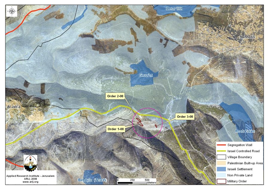
The Israeli Civil Administration served new military orders holding number 1/08, 2/08, 1/03 to Abu Fanoun family in Nahalin village, southwest of Bethlehem Governorate. The orders state the confiscation of five dunums of Palestinian lands in the area adjacent to the Israeli controlled bypass road # 367 conducted under the pretext of being 'State Land.”
The landowners were given 45 days from the date the orders were issued on November 26, 2008 and to file their objections against the confiscation orders at the Objection military committee at Ofra military Camp in Ramallah. If the family did not evacuate the lands within the specified period time, the Israeli Army will do so and will fine the owners the costs of evacuation. Below are details about the military orders.
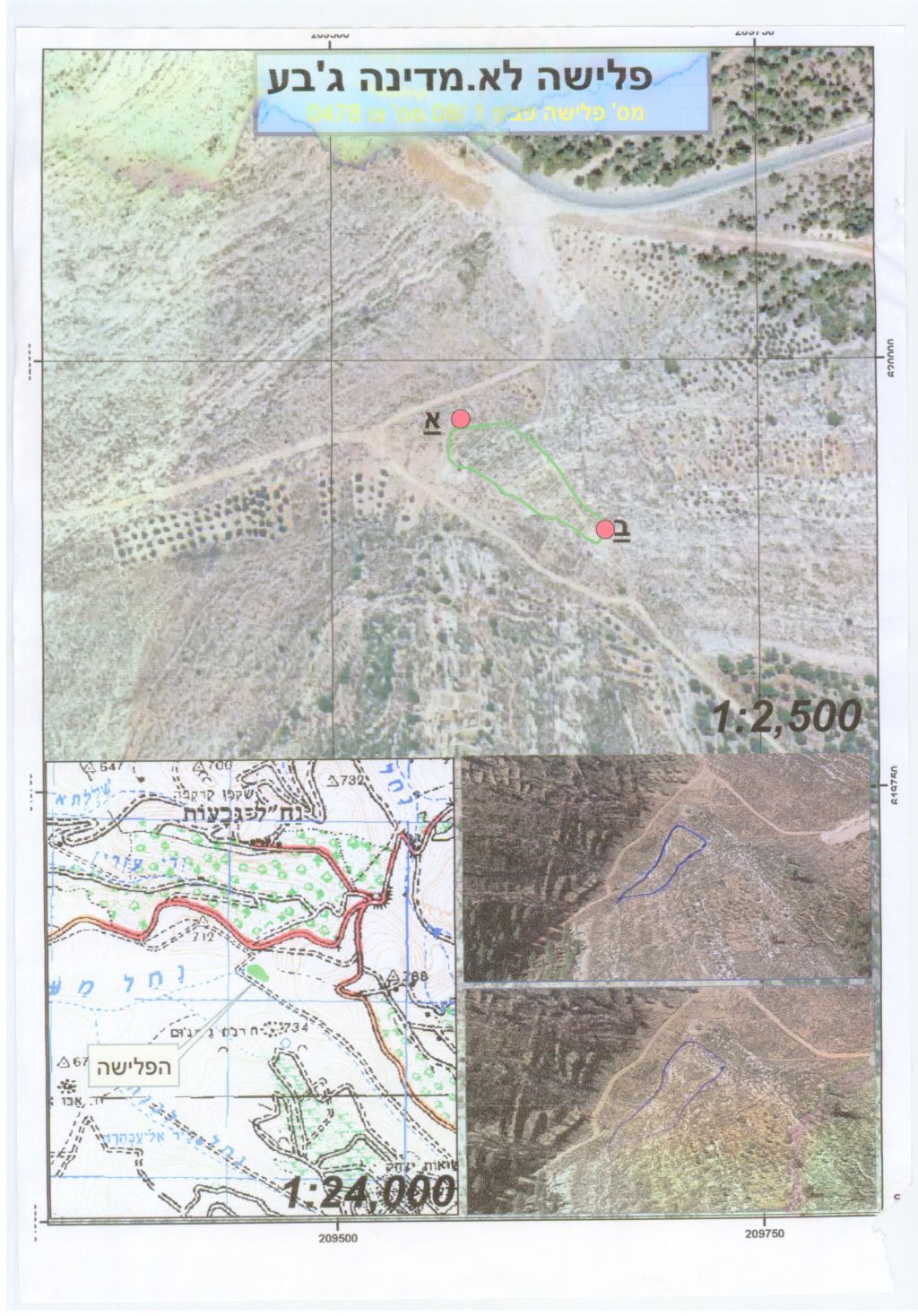
1. Military order 08-1 (0478): The area targeted in the military order is located to the south of Geva’ot Israeli settlement and to the west of bypass road # 367, which confiscates 2.6 dunums of lands.
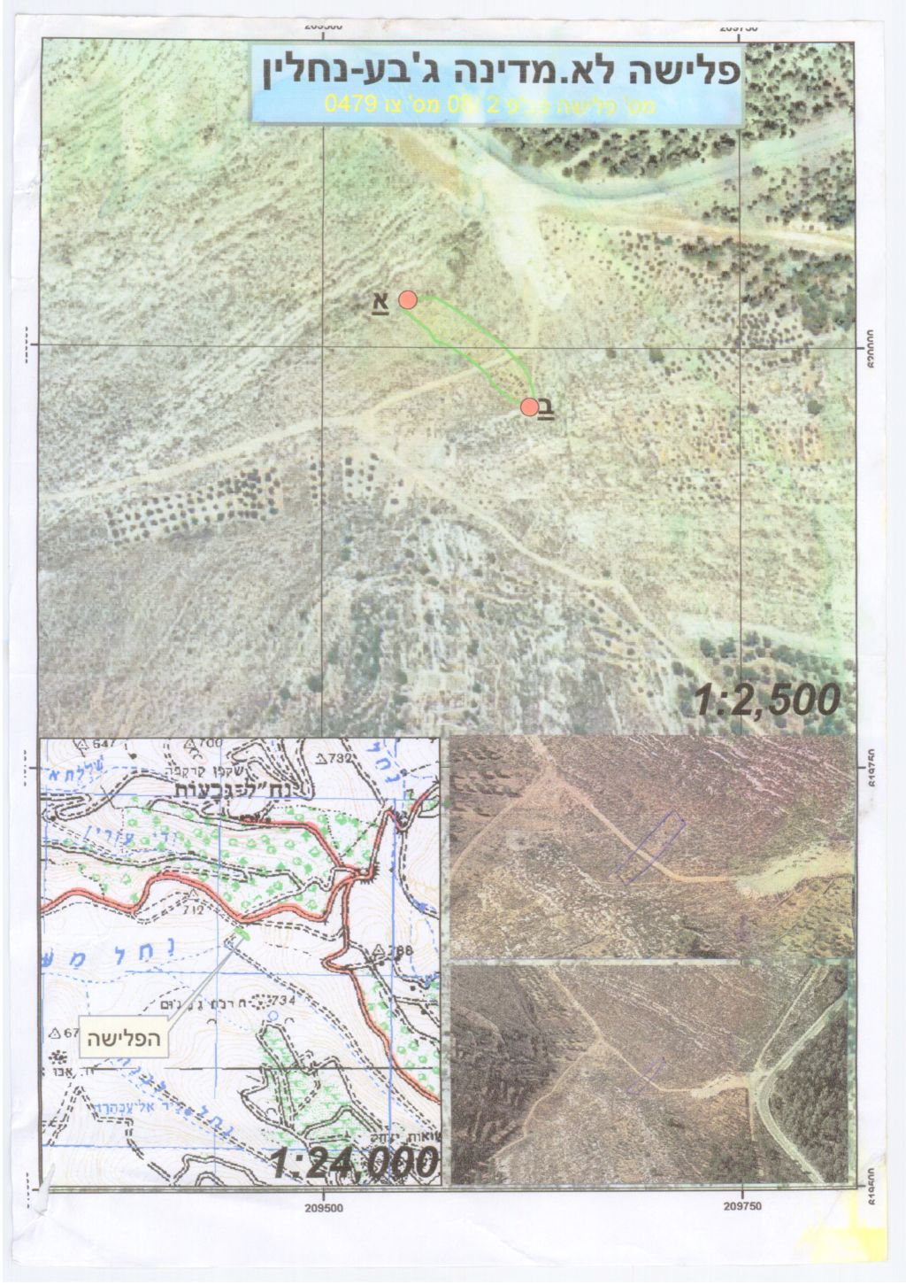
2. Military order 08-2 (0479): The area targeted in the military order also lies to the south of Geva’ot Israeli settlement adjacent to the Palestinian lands threatened by military order 08-1. This military order states the confiscation of 1.7 dunums of lands.
3. Military order 08-3 (0480): This military order confiscates 0.7 dunums of lands located nearby the targeted areas in Nahalin village.
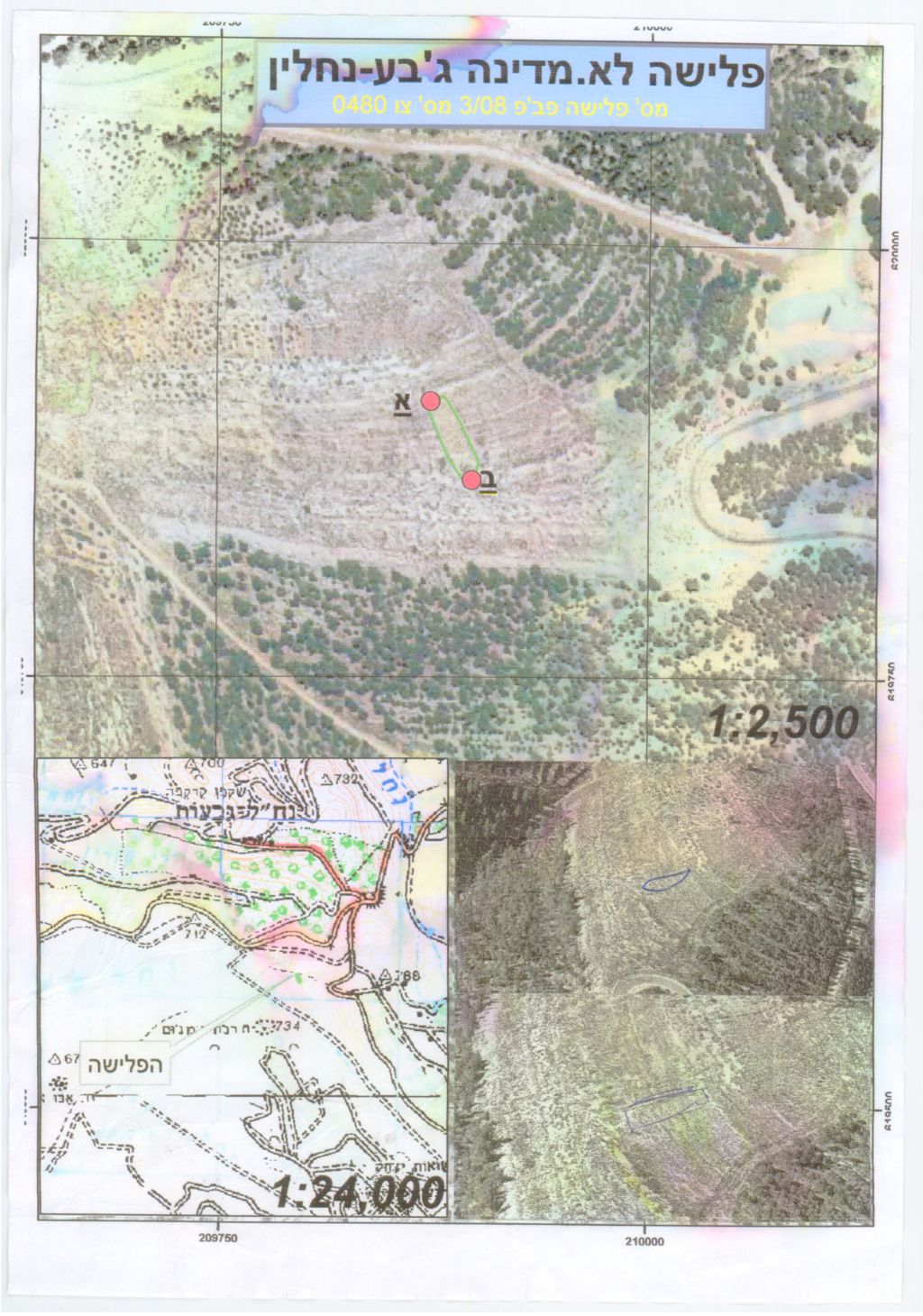
See Table 1 below.
|
Table1: Israeli military orders in Nahalin village |
||
|
No. of military order |
No. of Map |
Area/ Dunums |
|
478 |
08-1 |
2.6 |
|
479 |
08-2 |
1.7 |
|
480 |
08-3 |
0.7 |
|
Total |
5 |
|
Source: Nahalin Village Council- 2008
Nahalin village is located eight kilometres southwest of Bethlehem Governorate. Its population is 7457 (Palestinian Central Bureau of Statistics – PCBS, 2008). The village spreads over an area of 17250 dunums of lands, of which 496 dunums of lands compromises the Palestinian built- up area (2.8% of the total village area).
During the past decades, the Israeli Governorates managed to confiscate 3278 dunums of lands from Nahalin village to establish one outpost, Six Israeli settlements, and military bases on lands privately owned by the villagers of Nahalin. The Six settlements are among eleven Israeli settlements forming what the Israeli call ‘Gush Etzion settlements' bloc, which was established after Israel occupied the Palestinian Territory in 1967. These settlements, including the ones built on Nahalin’s lands spreads over 69738 dunums of lands. See Table 2.
|
Table 2: Israeli settlements surrounding Nahalin village |
|||
|
Israeli settlement |
Date of Establishment |
Pop 2006 |
Area/ Dunums |
|
Geva'ot |
1984 |
44 |
135 |
|
Betar 'Illit |
1985 |
29000 |
688 |
|
Rosh Zurim |
1969 |
364 |
889 |
|
Allon Shevut |
1971 |
3300 |
589 |
|
Kfar Etzion |
1967 |
422 |
583 |
|
Bat Ayin (Tzurif) |
1989 |
804 |
104 |
|
Total |
33934 |
2988 |
|
Source: ARIJ Database 2008
Nahalin village and the Israeli Segregation plan
Based on ARIJ analysis to Satellite images, Nahalin village along with the rest of western rural villages Husan, Battir, Wadi Fukin, and Al Jab'a are going to be entrapped in one big enclave where a population exceeding 21,000 Palestinian residents will be segregated between the Segregation Wall path and the 1949 Armistice Line (Green Line). These threatened Palestinian communities will be isolated with no geographical contiguity with other Palestinian areas in the Governorate, particularly from the main urban center of Bethlehem city where private, public, and vital services such as hospitals, universities, schools, and organizations are located. More than that, the communities will become overcrowded due to their inability to build, expand, and absorb natural population growth as the Israeli impose more restrictions on land use there. See Map 1
'Israeli bypass roads” in Nahalin village
Moreover, Nahalin village lost 9511 dunums of lands for the construction of bypass roads # 367 and 3676, which extend a length of nine kilometres on the lands of the village. Israeli bypass road # 367 stretches about 11 kilometres in the Palestinian communities of Surif, Al Jab'a, and Beit Ummar, of which 6 kilometres cross through the lands of Nahalin. This bypass road connects the Israeli settlements of Geva'ot, Rosh Zurim, Allon Shevut, Kfar Etzion, and Bat Ayin (Tzurif). Furthermore, an addition one kilometer planned bypass road, which will confiscate about 1487 dunums of village’s lands, will be constructed sometime during by the year 2010.
The Israeli strategies adopted by the Israeli Occupation Forces and Authorities in the Occupied Palestinian Territory violate all human rights under international law and the Fourth Geneva Convention of 1949 and constitute a crime of Apartheid according to the International Convention on the Suppression and Punishment of the Crime of Apartheid (1973) which defines apartheid as: 'the imposition of various legislative measures on different racial groups while injuring the rights of one. Moreover, the crime of Apartheid comprises a 'crime against humanity' and 'a serious threat to international peace and security'.
Prepared by
The Applied Research Institute – Jerusalem


