• About The Project
  • Palestine in Century
  • Selected Maps
  • Glossary
  • About ARIJ
  • About LRC
  • By Year
    • Case Studies By Year
    • Daily Report By Year
Friday, November 7, 2025
POICA
No Result
View All Result
  • Home
  • Settlements
    • New Israeli Settlements
    • Settlement Expansion
  • Israeli Violations
    • Agriculture
    • Confiscation
    • Demolition
    • Environment
    • Eviction of Palestinians
    • Settlers Attacks
  • Bypass Roads
  • Israeli Plans
  • Segregation
    • Checkpoints
    • Closure
    • Separation Plans
  • Military Orders
  • Reports
    • Daily Report
    • Monthly Report
    • Quarterly Report
No Result
View All Result
POICA
No Result
View All Result

Israeli Occupation Authorities Issue a Master Plan for the Village of Brokin

October 13, 2008
in Israeli Plans
Israeli Occupation Authorities Issue a Master Plan for the Village of Brokin

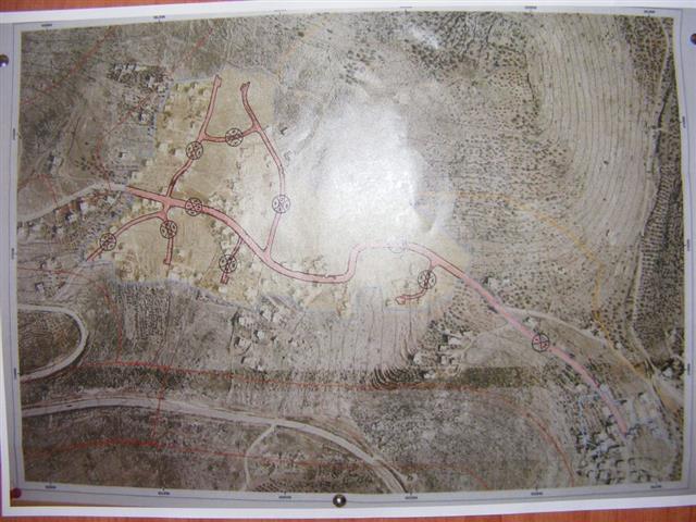
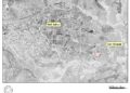
On the 7th of September, 2008 the so-called 'Organization and Building Committee' branch of the Israeli Civil Administration issued a Master Plan for the village of Brokin. According to the text of the Plan, the Israeli occupation authorities have allowed Brokin villagers to build on an additional 52 dunums located in Arae C. The announcement of the Master Plan was published in Ha'aretz newspaper and it gave the village council an objection period until the 7th of November 2008. The official announcement was not submitted to the Brokin village council. See Photo 1

The Master Plan, if it is implemented in its current form, would legitimize the Israeli occupational practices in Arae C and it would allow the return of only a small portion of the villages' lands to its owners. This, in turn, would allow the occupation authorities to confiscate the largest portion of the villages' lands for the purpose of enlarging nearby colonies.


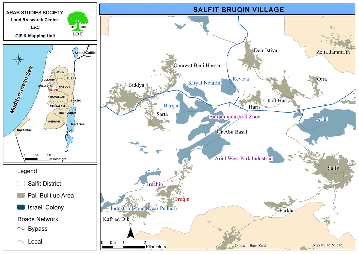
It is worth pointing out that the village of Brokin has been the target of an intense land confiscation campaign by the occupation forces. Most of the confiscated lands (area = 8,000 dunums of its 13,237 total area) have been used to expand the three colonies built atop the village's agricultural lands. The three colonies are:


Colony

Date of Establishment

Area (in m2)

Type

Nearby Palestinian Villages

Burkan

1981

622.5

Industrial

Sarata, Brokin, Haris

Brokhin

1999

265.5

Residential and industrial

Brokin. Haris

Ariel Gardens

1978

5226

Industrial

Brokin

Total


6114


The negative impact of the presence of the afore-mentioned colonies does not stop at preventing Palestinians from accessing their lands as these colonies have played a major role in polluting the environment in its immediate vicinity; the sewage and waste water stemming from these colonies into the nearby Palestinian villages caused a number of diseases in the villages especially skin diseases. Also, a marked increase in abdomen and kidney failure cases have been reported in the villages. Moreover, the gases emitted from the factories of the colonies led to the spread of respiratory diseases. These pollutants caused the increase presence of insects and rodents in the area, not to mention its effect on the agricultural and animal food chains affecting, in the end, humans.


General Information about Brokin Village:

The village is located 12 kilometers south of the city of Salfeet. Its population is around 3,500 Palestinians most of which depend on agriculture as the main source of income. The total area of the village is about 13,273 dunums of which 1,336 is its built-up area. There are 1,200 dunums planted with olive tree while 3,000 dunums are used for grazing purposes while 8,000 dunums of its lands were confiscated for colonial purposes.


Prepared by:
The Land Research Center
LRC


Recommended For You

الدورة الشتوية للكنيست الإسرائيلي 2025: الضم كسلاح سياسي وإقليمي

by arij
October 25, 2025
0

افتتحت الدورة الشتوية للكنيست الإسرائيلي وسط تصاعد التوترات، وتميزت بهجوم حاد من الحكومة على القضاء. في كلمته الافتتاحية، انتقد رئيس الوزراء بنيامين نتنياهو القضاء مباشرة ودافع عن العمليات...

Read moreDetails

The Israeli Knesset Winter Session 2025: Annexation as a Political and Territorial Weapon

by arij
October 25, 2025
0

Executive Summary The winter session of Israel’s Knesset opened amidst heightened tensions, marked by a sharp government attack on the judiciary. Prime Minister Benjamin Netanyahu, in his opening...

Read moreDetails

منطقة (H2): المساعي الاستيطانية لإسرائيل في تشكيل جغرافيا وديموغرافيا مدينة الخليل التاريخية

by arij
November 3, 2025
0
Israeli Breach of the Hebron Agreement through the Establishment of a New Settlement in Area (H1)

 الوضع الجيوسياسي وديمغرافيا منطقة (H2) في مدينة الخليل  تعد مدينة الخليل واحدة من أقدم المدن الفلسطينية المأهولة وأكثرها أهمية دينية واقتصادية وسياسية في الضفة الغربية، إذ تقع في...

Read moreDetails

الرئاسة الثانية لترامب: فرصة متجددة لطموحات إسرائيل التوسعية – ضم غور الأردن والتداعيات على حل الدولتين واستقرار المنطقة

by arij
October 14, 2025
0
Annexation of the Jordan Valley: Implications for the Two-State Solution and Regional Stability

تجددت مساعي وطموحات إسرائيل لضم غور الأردن، مع فترة الرئاسة الثانية للرئيس الأمريكي دونالد ترامب وبتأييد من ائتلاف رئيس الوزراء بنيامين نتنياهو اليميني المتطرف، والتي أصبحت نقطة تحول...

Read moreDetails

محافظة أريحا على خريطة المصادرة الإسرائيلية- إسرائيل تسعى للاستحواذ على أكثر من 7000 دونم في منطقة النبي موسى

by arij
October 13, 2025
0
محافظة أريحا على خريطة المصادرة الإسرائيلية- إسرائيل تسعى للاستحواذ على أكثر من 7000 دونم في منطقة النبي موسى

في العاشر من شهر أيلول من العام 2025، نشرت ما تُسمّى "بدائرة أراضي إسرائيل" ستة إعلانات جديدة مفادها بأن ما يُعرف بـ*"المسؤول عن أملاك الحكومة"* في الضفة الغربية...

Read moreDetails
Next Post
قوات الاحتلال تصدر مخطط هيكلي جديد في قرية بروقين

قوات الاحتلال تصدر مخطط هيكلي جديد في قرية بروقين

LATEST NEWS

“ما يزيد عن 25 ألف دونم من أراض الزيتون”,
موسم الزيتون في فلسطين تحت رهن الأوامر العسكرية

by arij
November 3, 2025
0

........................................................

From conflict Resolution to Conflict Management

حول تسجيل الأراضي في مناطق “ج”: سياسة سموتريتش لتمكين السيطرة الإسرائيلية على الأراضي الفلسطينية

by arij
November 3, 2025
0

........................................................

الدورة الشتوية للكنيست الإسرائيلي 2025: الضم كسلاح سياسي وإقليمي

by arij
October 25, 2025
0

........................................................

The Israeli Knesset Winter Session 2025: Annexation as a Political and Territorial Weapon

by arij
October 25, 2025
0

........................................................

flag_yellow_lowEU-PfP-Logo

This website and its content were initiated in 1993 by the Applied Research Institute – Jerusalem (ARIJ) and the Land Research Center (LRC) with the support from the European Union up until 2023. Since then, the Applied Research Institute – Jerusalem (ARIJ) has taken over the continued development and maintenance of the website. The views expressed remain solely those of ARIJ) and do not necessarily reflect those of the European Union.

© 2025 Copyright ARIJ . All Rights reserved. .

No Result
View All Result
  • Home
  • Settlements
    • New Israeli Settlements
    • Settlement Expansion
  • Israeli Violations
    • Agriculture
    • Confiscation
    • Demolition
    • Environment
    • Eviction of Palestinians
    • Settlers Attacks
  • Bypass Roads
  • Israeli Plans
  • Segregation
    • Checkpoints
    • Closure
    • Separation Plans
  • Military Orders
  • Reports
    • Daily Report
    • Monthly Report
    • Quarterly Report

© 2025 Copyright ARIJ . All Rights reserved. .