Geography
The Eastern strip of the West Bank encompasses the middle and lower parts of the Jordan Valley and the upper part of the Dead Sea western shores. In average it extends 106 kilometers long and 15 kilometers wide where it runs from the Negave in the south to Bisan in the north, from the Jordan River and the Dead Sea western shores in the east to reach the Mountains ridge of the West Bank in the west, with total area 1576 Km² representing 27.8 % of the west bank, contains 42 Palestinian communities including more than 52132 Palestinian people (the Palestinian Central bureau of Statistics, PCBS 2005) and 43 Israeli settlements including 8854 Israeli settlers (Israeli Central Bureau of Statistics,2004)
Why considered strategic Geography?
A wide variety of factors make the eastern strip of the west bank one of the most strategic area in OPT
1- Rich of fertile soils and water resources
Future water security is a cause of concern for both Palestinians and Israelis, as both populations are expected to grow; hence increasing the demand for fresh water will also increase. This is to meet the needs of the future population, but also to meet the needs of the present and the future population of both peoples and also to allow economic development. This comes with the fact that the eastern strip of WB contains the greatest water sources in the area.
-
Jordan River system: The Jordan River watershed has the largest water yield in the region, as it provides most of the usable surface water supply (EXACT, 1998). With a surface catchments area of 18300 Km². As the only significant source of surface water in the region the Jordan River has been the source of conflicts between the countries that share it (Jordan, OPT, Israel,Syria,Lebanon).
-
Eastern Aquifers system : which officially recognized annual recharge 172 MCM/Year
-
The Jordan Valley lies in a climatic zone that is distinguished by being several degrees warmer than the rest of the surrounding climatic zones. This feature in addition to the presence of the fertile soils and the presence of water resources makes the valley an agricultural rich area. The Jordan Valley produces 25.2% of the West Bank's total vegetable production, 5% of fruit tree production and 1.25% of the field crops production (ARIJ database 2006).
2- Rich of Minerals
-
Mineral salts: The Dead Sea contains about 21 mineral salts, among which some are not found in any other sea or ocean. These include sodium, magnesium, calcium, bromine, bitumen and potassium. However, compared with ordinary sea water, the Dead Sea contains 20 times more potassium, 32 times more magnesium and 81 times more bromine. This makes bromide ion concentration in the Dead Sea the highest of all waters on Earth ( ARIJ database2007).
-
Other minerals: Native sulphur is found in the north of Fasayil- Jericho Governorate, Small quantities of low grade iron-ore deposits (47% Fe) are found in the east of Kherbit Yarza – Tubas Governorate and apatite ore of Phosphate is found on the west shore of the Dead Sea. (ARIJ database2007).
The unique nature and the vacation site made the area an economic resource of major importance for industry and tourism.
3- The Palestinians' main gateway to the Arab world
As a sole crossing point between the west bank and the Arab world, the Eastern zone of the west bank representing the only gateway for the Palestinians to communicate with their Arab neighborhoods .Potentially it will plays significant role in drawing the future Palestinian state as the only border with a country rather than Israel.
4- This is the only area where there is enough open space (642.78 km² about 11.3 % out of west bank) for new Palestinian cities to Absorb exile returnees
The Eastern Segregation Plan
After Israel captured the West Bank in the 1967 Six-Day War and UN Security Council Resolution 242 opened the door to modifications of the prewar boundaries, Israeli military planners began to consider how the resolution's call for 'secure and recognized boundaries' might be implemented.
It was Israel's deputy prime minister, Yigal Allon, who first proposed to the Israeli cabinet just after the Six-Day War on July 26, 1967, that Israel retain new borders based primarily on control of the eastern slopes of the West Bank hill ridge down to the bottom of the Jordan Valley, as well as the eastern west bank Desert that was adjacent to the Dead Sea
Over the years of the Israeli Occupation of the eastern west bank area, 43 illegal Israeli settlements holding a number of 8854 Israeli settlers were constructed on 38.11 km² of lands confiscated from Palestinians. It is worth pointing out that Israel has encouraged Israeli settlers to settle in the Jordan Valley by offering them free land, free houses and free education. They did not just construct settlements and outposts the most important were the military bases. Over the years, Israel has constructed 77 military bases in the Jordan Valley which occupy an area of 32.87 km² all of which owned by Palestinians and were confiscated under the pretext of 'security needs'. The Israeli military bases as much as the Israeli settlements added up more obstacles on the Palestinian communities; as they represented constant danger and threat to the lives of the Palestinians living in the nearby areas, of whom many have died during the daily Israeli Army's military activities.
In recent years, Israel has set up seven permanent checkpoints west of the Jordan Valley and north of the Dead Sea, four of them around the Jericho enclave. In 2005, the army placed much restrictions on Palestinians wanting to cross these checkpoints in January 2006 announced that crossing these checkpoints is allowed only to residents of the Jordan Valley whose identity cards indicate that they live in one of the villages in the zone. Other residents of the West Bank are allowed to cross only if they have a special permit issued by the Israeli Civil Administration.
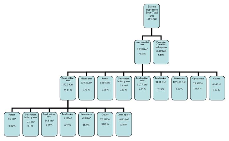
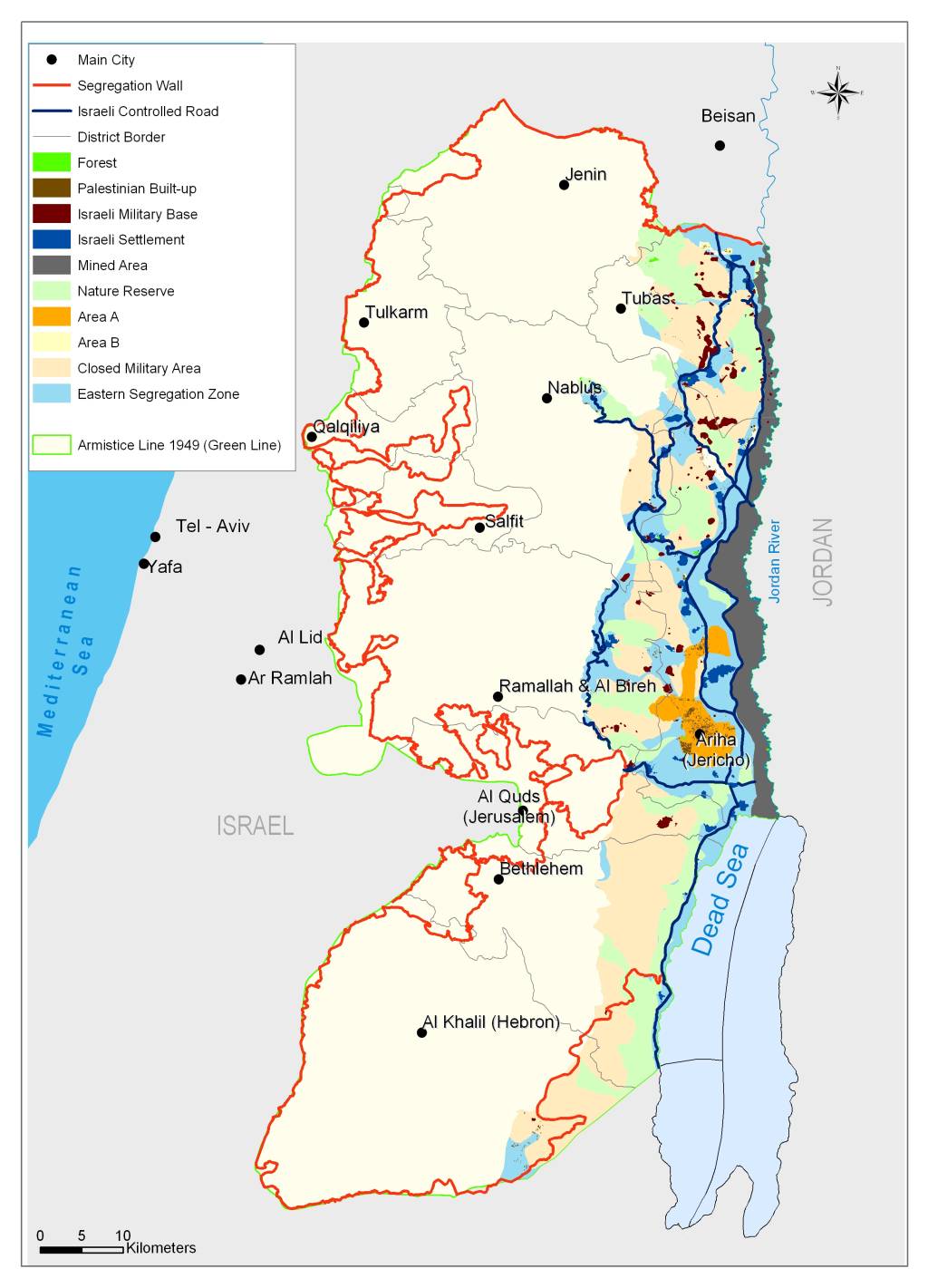
The 2007 Israeli plans for the eastern Segregation Wall is set to seize some 29.4% (1664 Km2) of the West Bank total area. The wall will have no physical structure to segregate the area; nevertheless, the Israeli Army is set to hold control over the area with military controlled checkpoints along the 200 Km stretch from north to south. It should also be noted that 855.5 Km2 of the eastern segregation zone is already classified as closed military area and 150 Km² considered mined area. This leaves only 71.229 km² (4.2 % of the zone) for Palestinians which also included in the segregation plan. (ARIJ database 2007). See Diagram and Maps Below

-
Total Palestinian Built-up area = 74.229 km² = 4.46 % out of the total area
-
Total Israeli military bases area = 32.877 km² = 1.98 % out of the total area
-
Total Israeli colony area = 38.11 km² = 2.3 % out of the total area
-
Total natural reserve area = 332.537 km² = 20 % out of the total area
-
Total Forest area = 1.398 km² = 0.08 % out of the total area
-
Total open space area = 642.784 km² = 38.62 % out of the total area
 x
x
The Impacts of the plan
The eastern Segregation zone will effectively isolated 42 Palestinian communities with population exceeding 52,000 Palestinians who were and still are systematically subjected to all kinds of coercion (house demolition, confinement, land confiscation, denial of basic medical services or proper educational facilities, hygienic drinking water, etc) exercised by the Israeli Army to push them to abandon their lands although these communities are spread over areas classified as A (occupying 69 Km2 out of the Eastern Zone area ;4.1 % ) & B (2 Km2 out of the Eastern Zone area ;0.1 %) (According to Oslo agreement of September 1993) and are no where connected to the West Bank except through Israeli controlled areas and via Israeli checkpoints. The 4.2 per cent of the zone that remains for the Palestinians will consist of a ghetto around Jericho and a cluster of small, isolated villages without land. Despite this humanitarian issue there are other impacts of this plan over the Palestinians:
-
With respect to Economics & agriculture: Currently the estimated number of Palestinian workers in the agricultural sector in the Jordan valley and the eastern strip is 3557 person (PCBS 2005), but with the inclusion of the Jordan Valley in the segregation area will denies the Palestinian population the possibility for agricultural development and thus increasing the unemployment rate and decrease agricultural production which will effect all the west bank. Dead Sea is also an economic resource of major importance for industry, but the restrictions imposed by Israel will denied Palestinians the opportunity to utilize this resource
-
Regarding Mobility: as the only gateway for the Palestinians to the world, segregating the eastern strip will isolate the Palestinians and make the west bank the largest prison on earth.
-
Regarding urban development: As the only area where there is enough open space for new Palestinian cities to Absorb exile returnees the annexation of this part of the west bank will denies the Palestinian from natural population expansion and building new cities and Preventing any possibility for significant urban development.
-
Regarding Final status negotiations: Since the occupation of the West Bank began, in 1967, every Israeli government hasconsidered this strip to be the 'eastern border' of Israel and has sought to annex it. Recently, Israel's acting Prime Minister Ehud Olmert, stated in a TV interview that 'the Jordan Valley will remain under Israeli control in any future diplomatic agreement'.
This de facto annexation would prejudge subsequent negotiations as to what a Palestinian state may look like.
Prepared by
The Applied Research Institute – Jerusalem


