Beit Jala city: Location & Population
Beit Jala city is located one Kilometer west of Bethlehem city and 8 Kilometer southwest of Jerusalem at an altitude ranging between 650 – 930m above sea level. The village boundary of Beit Jala spread on 13340 dunums on slopes of hills covered with Olive trees, Vineyards and Apricots trees. Beit Jala is the home of 16700 inhabitants (Palestinian Central Bureau of Statistics, 2007).
Beit Jala City following the 1967 Israeli Occupation
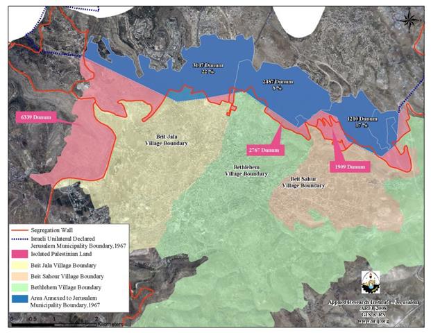
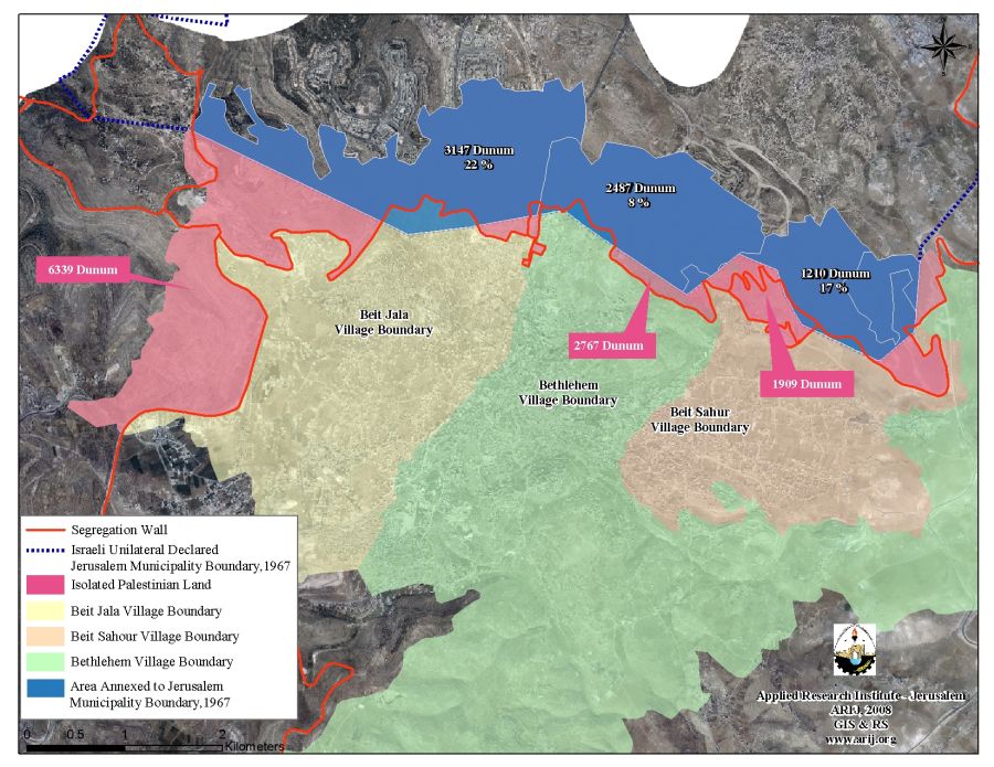
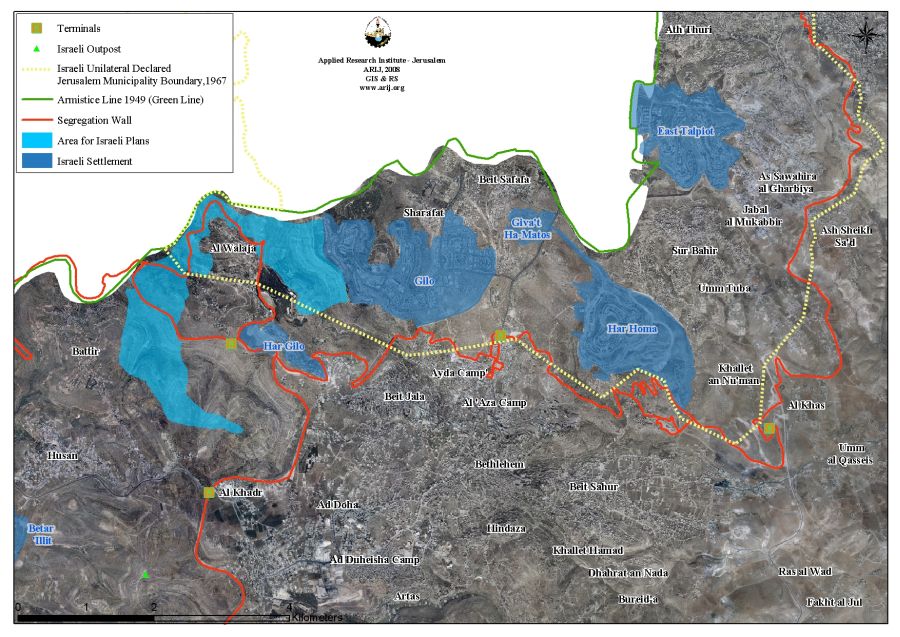
Following the 1967 Israeli Occupation of the West Bank and the Gaza Strip, the Israeli Government had unilaterally expanded the Jerusalem municipal boundary to include lands from surrounding villages and cities. Beit Jala was among the Palestinian cities that had parts of its lands expropriated to the new illegal boundary of Jerusalem; hence, 3,147 Dunums; some 22% of Beit Jala's lands were included within the Israeli defined but illegal boundary of Jerusalem; See Map 1.
The Palestinian residents who live or/and own lands close to the perimeter of the new expanded municipal boundary of Jerusalem have always been subject to constant aggravation and stalking by the Israeli occupation authorities in an attempt to drive them out of their lands and houses. The Israeli practices against the Palestinian citizens' came in various forms but are mainly represented in the denial of building permits, denial of civil services and the demolition of houses under the pretext of ''building without permits.
The Israeli Occupation Practices in Beit Jala City
1- Israeli Settlements
Beit Jala has always been a target of the Israeli activities due to its strategic location; being close to Jerusalem and to the Green Line. Gilo and Har Gilo are two Israeli settlements constructed on lands originally belong to Beit Jala. These settlements are among the first wave of Israeli colonization activities in the occupied West Bank territory.
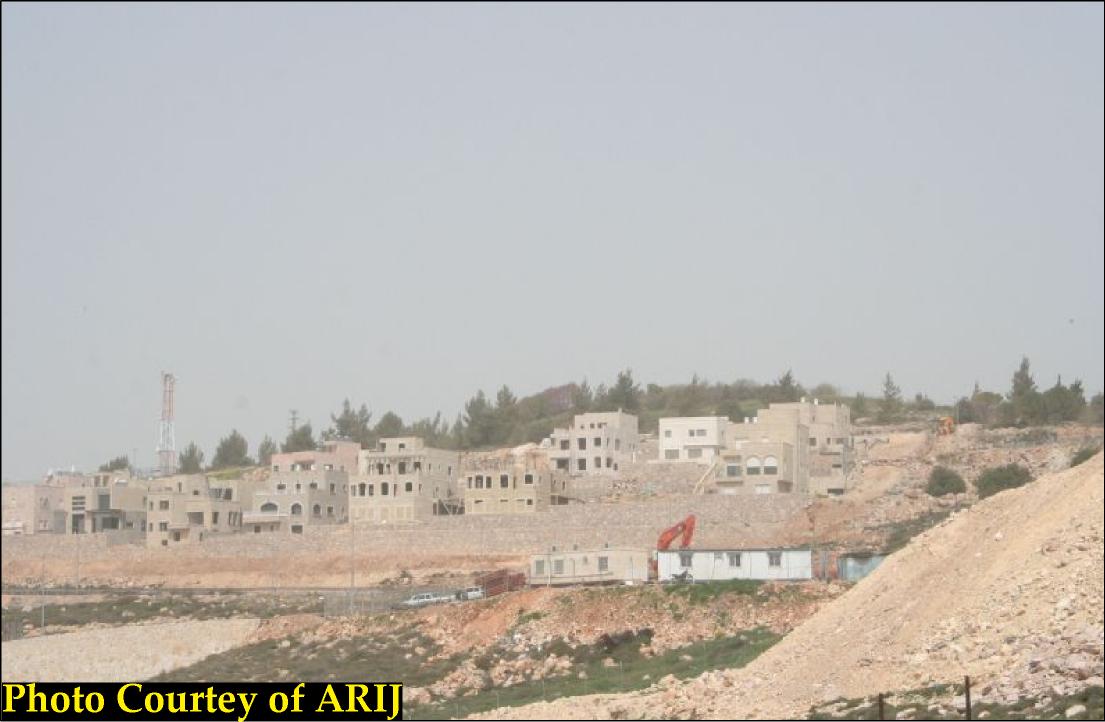
Gilo settlement was established in 1971 and has an area of 2738 Dunums, of which 1117 dunums were confiscated from the lands of Beit Jala. Today the settlement is inhabitant by more than 31500 Israeli settlers. See Photo 1 & Photo 2

Photo 1: Gilo settlement and the Israeli Segregation Wall
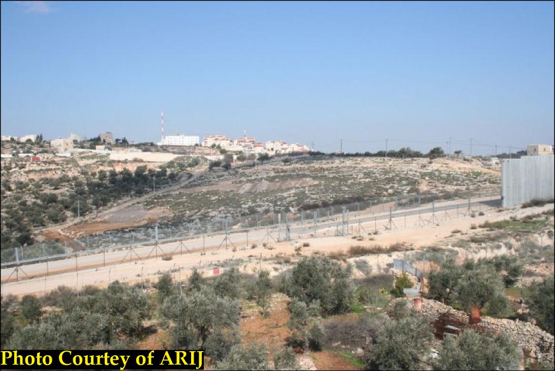
Photo 2: Gilo settlement
Har Gilo is the second Israeli settlement established on 314 dunums belonging to residents from Beit Jala. In 2007, Har Gilo had a total area of 420 dunums and a settler population of 414. See Photo 3
2- Israeli Bypass Roads
Israeli Bypass Road number 60, better known 'The Tunnel's Road'
Road number 60 is an Israeli restricted highway that runs across the West bank and runs in Israel. In the West Bank, it works to link the settlements together and in the Jerusalem area and Bethlehem area, it provides access between the Gush Etzion settlements bloc southwest of Bethlehem with Gilo settlements and Israel from that point on.
The 'Tunnel's road' is the section of road 60 that penetrates the western part of Beit Jala and places much of its agricultural lands west of it. Construction of this section started following the Oslo II Accords in 1995. This section of Road 60 penetrating Beit Jala's lands is made up of three parts; one part of it is a bridge elevated above the agricultural lands and the other two parts are tunnels that penetrates Beit Jala's mountains.
On December 15, 2005, the Israeli Forces distributed a new military order (Order Regarding Closed Zones, Judea and Samaria, No. 34, 5727-1967) that forbids Palestinians holding valid permits from entering Israel via bypass roads, including Road 60, which became restricted only to the Israeli settlers use. Furthermore, the Israeli military order banned Israelis from transporting Palestinians on these roads.
The tunnel's road is part of the network bypass roads system that Palestinians with valid permits are allowed to use only within certain frame of rules, in addition to those Palestinians who work with international organizations and hold extended time permits to enter Israel (permits with three months time period or more). See Photo 4

3- The Israeli Segregation Wall plan thinning the area of Beit Jala City
Beit Jala city is now facing a grave danger of the Israeli Segregation Wall that may very much compromise the city's endurance. The part-section of the Segregation Wall in Beit Jala's lands has a total length of 11 km, currently 9 kilometers of which are constructed, one kilometer is planned, and another kilometer is under construction.
The Wall extends from the northeastern part of Beit Jala, runs along the northern part of 'Aida refugee camp, cuts through Beit Jala's northern lands, stretches west towards Gilo settlement, it then continues until it reaches bypass road 60 (the tunnel section) where it runs parallel to it. The Wall stands to isolate an additional area of 3192 Dunums; bringing the total amount of land expropriated and isolated from Beit Jala toward the Israeli municipality of Jerusalem and now behind the Segregation Wall to a total area of 6339 Dunums -approximately 48% of Beit Jala's lands- will be totally lost or partially accessible to Beit Jala's residents.
Palestinian Natural resources isolated by the Segregation Plan in Beit Jala City
Agricultural areas
-
Up to 3538 dunums of agricultural lands are isolated north and west of the Segregation Wall, which form 56% of the total agricultural lands in Beit Jala.
Open space
-
Up to 569 dunums of open space and forested areas are segregated north and west of the Segregation Wall, which form 9% of the total areas in Beit Jala.
Forests and non- Vegetation areas
-
Up to 589 dunums of forested areas and areas with no vegetations are isolated behind the north and west of the Segregation Wall. It makes 9% of the total forested area and area with no vegetations of Beit Jala. The only remaining forest (Cremesan forest), which is the only recreational site in the area where many citizens go to during weekends or holidays will be isolated as well.
Artificial landscape
-
Up to 28 dunums of Artificial lands are isolated north and west of the Segregation Wall in Beit Jala city.
Entrance to the isolated area like the agricultural lands will only be limited to those who are able to prove landownership through an Israeli organization (most likely to be the Civil Administration) and only the owners whose names listed in the ownership deeds (usually the eldest of the families) or their inheritors will receive permits. Furthermore, the Israeli Civil Administration will only issue permits on seasonal basis and access will be through specially rigged gates to these areas and within specified hours of the day. Hence, the owners will find a hard time to manage their lands on their own especially that the permits do not include additional labor or equipments. Table one below shows the Land Use/Land Cover of Beit Jala city and the land Use/Land Cover of the areas isolated by the Segregation Wall.
Table 1: the Land Use/Land Cover of Beit Jala city & the
land Use/Land Cover of the areas isolated by the Segregation Wall
|
Land classification Land Use/ Land Cover |
LULC inside the village boundary of Beit Jala |
LULC in the area isolated north and west of the Wall |
Percentage |
|
Agricultural land |
7158 |
3538 |
49% |
|
Open spaces with little or no vegetation |
1934 |
569 |
29% |
|
Forests and non- Vegetation areas
|
864 |
589 |
68% |
|
Artificial landscape |
342 |
28 |
8% |
|
Palestinian Built-up area |
1514 |
176 |
12% |
|
Israeli settlement |
1526 |
1439 |
94% |
|
Others |
2 |
0 |
0% |
|
Total |
13340 |
6339 |
48% |
Source: ARIJ database- GIS, 2008
4- Israeli Military Orders in Beit Jala City
Israeli Military orders issued in Year 2002
** Military Order No. (T/08/02))
On October 16, 2002, the Israeli Occupation Force has issued military order number T/08/02 stating the confiscation of 95 dunums from Beit Jala lands to build a part-section of the Segregation Wall. The Wall section in the military order has a total length of 2 km and extends from the northeastern part of Beit Jala (north of 'Aida refugee camp) penetrating Beit Jala northern lands and heads westwards towards bypass road number 60 (known as the tunnel road). 1.6 km of the military order is already constructed, while the section northeast of 'Aida camp was rerouted in military order number T/14/03 and completed accordingly. stating the confiscation of 95 dunums from Beit Jala lands to build a part-section of the Segregation Wall. The Wall section in the military order has a total length of 2 km and extends from the northeastern part of Beit Jala (north of 'Aida refugee camp) penetrating Beit Jala northern lands and heads westwards towards bypass road number 60 (known as the tunnel road). 1.6 km of the military order is already constructed, while the section northeast of 'Aida camp was rerouted in military order number T/14/03 and completed accordingly.
Israeli Military orders issued in Year 2003
** Military Order No. (T/44/03))
On July 3rd, 2003 the Israeli Chief Commander of Judea and Samaria issued military order number T/44/03 stipulating the confiscation of 23.8 dunums of lands from Al Walajeh and Beit Jala for constructing the Segregation Wall. The section of this order that lies in Al Walajeh is believed to be cancelled as the Israeli updated map approved by the Israeli Government on February 20th 2005 and published on the Israeli Ministry of Defense's website outlines a different route for the Wall in this area. The section of this order that lies in Beit Jala was updated by military order number T/32/04. . stipulating the confiscation of 23.8 dunums of lands from Al Walajeh and Beit Jala for constructing the Segregation Wall. The section of this order that lies in Al Walajeh is believed to be cancelled as the Israeli updated map approved by the Israeli Government on February 20 2005 and published on the Israeli Ministry of Defense's website outlines a different route for the Wall in this area. The section of this order that lies in Beit Jala was updated by military order number .
Israeli Military orders issued in Year 2004
** Military Order No. (T/32/04))
This military order was issued on March 25th 2004 and stated the seizure of 175.6 dunums of Beit Jala city and Al Walajeh village lands for the construction of the Segregation Wall. This Wall section is located in the northwestern part of Beit Jala city. Another section of the military order stretches around the southern and southeastern sides of Har Gilo settlement. This order was amended in November 2005. The amendment indicated the cancellation of wall sections suggested in the orders (T/32/04) and (T/57/04), near the tunnel road area. Another amendment was made by military order number T/01/06, which was issued on January 29, 2006.), near the tunnel road area. Another amendment was made by military order number T/01/06, which was issued on January 29, 2006.) and (), near the tunnel road area. Another amendment was made by military order number T/01/06, which was issued on January 29, 2006.
** Military Order No. (T/57/04))
This Israeli military order was issued on May 23, 2004, for the confiscation of 11.8 dunums from Beit Jala's lands to construct part-section of the Segregation Wall. This order is complementary to the previously issued military order number T/32/04 in the year 2004. This order was also amended in November 2005. The amendment indicated the cancellation of wall sections suggested in the orders (T/32/04) and (T/57/04), near the tunnel road area. Another amendment was made by military order number T/01/06, which was issued on January 29, 2006.) and (), near the tunnel road area. Another amendment was made by military order number T/01/06, which was issued on January 29, 2006. in the year 2004. This order was also amended in November 2005. The amendment indicated the cancellation of wall sections suggested in the orders () and (), near the tunnel road area. Another amendment was made by military order number T/01/06, which was issued on January 29, 2006.
** Military Order No. (36/04 (A)))
On August 8th 2004, the Israeli Occupation Force issued military order number 36/04 stipulating the confiscation of 33 dunums of Beit Jala lands in order to construct the Segregation Wall. This Wall Section surrounds the southern entrance of the northeastern tunnel of bypass road number 60. This military order was reiterated in military order number T/62/06, which was issued on March 19 2006. stipulating the confiscation of 33 dunums of Beit Jala lands in order to construct the Segregation Wall. This Wall Section surrounds the southern entrance of the northeastern tunnel of bypass road number 60. This military order was reiterated in military order number T/62/06, which was issued on March 19 2006.
** Military Order No. (36/04 (B)))
This military order was also issued on August 8, 2004. It stated the confiscation of 33 dunums of Beit Jala's lands in order to construct an additional section of the Segregation Wall. This Wall Section is located in the northwestern part of Beit Jala near Cremesan forest. This military order was also reiterated in military order number T/62/06 which was issued on March 19, 2006. which was issued on March 19 2006.
** Military Order No. (T/99/04))
This military order was issued on December 30, 2004, stipulating the confiscation of 0.3 dunums of Beit Jala in block # 2, to construct colonial road in Bab Al Sharafa area north of Beit Jala.
Israeli Military orders issued in Year 2005
** Military Order No. (T/75/05))
On March 22nd 2005, the Israeli Occupation Force issued military order number T/75/05 stipulating the confiscation of 9.2 dunums of Beit Jala and Al Walajeh lands. This Wall Section comes along the road leading from Beit Jala to Al Walajeh. The military order was amended and replaced by military order number T/25/06 which was issued on February 9, 2006. stipulating the confiscation of 9.2 dunums of Beit Jala and Al Walajeh lands. This Wall Section comes along the road leading from Beit Jala to Al Walajeh. The military order was amended and replaced by military order number T/25/06 which was issued on February 9, 2006.
** Military Order No. (T/85/05))
On April 1, 2005, the Israeli Occupation Force issued military order number T/85/05 stating the confiscation of 14.3 dunums of Beit Jala and Al Walajeh lands. This Wall Section comes in the northwestern part of Beit Jala between Cremesan forest and Al Walajeh.
** Military Order No. (T/157/05))
This military order was issued on August 22, 2005, for the confiscation of 21 dunums from Beit Jala's lands for constructing part-section of the Segregation Wall. This Wall section is located at the southwestern part of Beit Jala city along bypass road number 60 near the road junction leading to the western entrance of Beit Jala.
** Military Order No. (T/201/05))
On November 2, 2005, the Israeli Occupation Force issued military order number T/201/05 stipulating the confiscation of 94.3 dunums of Beit Jala and Al Khader lands. This Wall Section lies in the southwestern part of Beit Jala along bypass road number 60. stipulating the confiscation of 94.3 dunums of Beit Jala and Al Khader lands. This Wall Section lies in the southwestern part of Beit Jala along bypass road number 60.
** Military Order No. (T/210/05))
This military order was issued on November 21, 2005 stating the confiscation of 85 dunums of Beit Jala, Al Khader and Battir lands. The lands are confiscated for constructing a terminal that would control the movement of Bethlehem western rural villagers who will be segregated west of the Segregation Wall and within the Gush Etzion settlements' bloc southwest of Bethlehem governorate.
Israeli Military orders issued in Year 2006
** Military Order No. (T/01/06))
This military order was issued on November 1, 2006 for the confiscation of 9 dunums of land for the construction of the Segregation Wall in Beit Jala city. This military order amends two previous military orders T/32/04 and T/57/04.
** Military Order No. (T/24/06) )
On February 19, 2006, the Israeli Occupation Force issued military order number T/24/06 stipulating the confiscation of 170 dunums of Beit Jala and Al Khader lands. This Wall Section lies in the western part of Beit Jala and extends from the northwestern part of Beit Jala along the road leading to Al Walajeh where it heads southwards along bypass road number 60, which proceed towards Al Khader village. stipulating the confiscation of 170 dunums of Beit Jala and Al Khader lands. This Wall Section lies in the western part of Beit Jala and extends from the northwestern part of Beit Jala along the road leading to Al Walajeh where it heads southwards along bypass road number 60, which proceed towards Al Khader village.
** Military Order No. (T/25/06) )
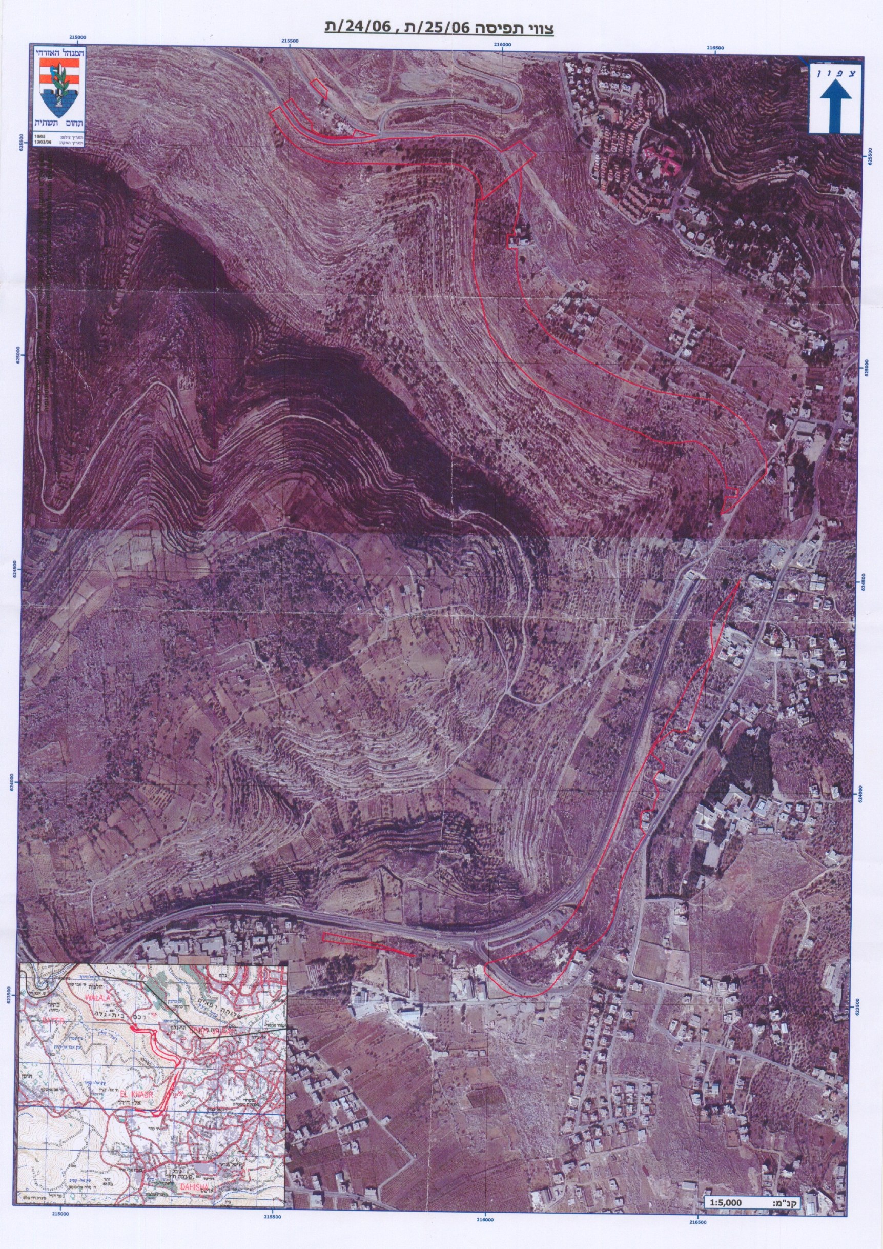
This military order was issued on the February 9, 2006 for the confiscation of 39.8 dunums from Al Walajeh and Beit Jala lands to construct a passage that would control the movement of Palestinian from/to Al Walajeh village.
** Military Order No. (T/62/06))
This military order was issued on March 19, 2006 for the confiscation of 178 dunums from the lands of Beit Jala. This order came to replace the previous military orders number 36/04 (A) and 36/04 (B). The new military order causes to isolated even more lands from Beit Jala.
** Military Order No. (T/66/06))
This military order was issued in March 2006 stating the confiscation of 90 dunums of lands from Beit Jala and Al Walajeh to establish colonial road extending from the northern part of Cremesan Monastery.
Israeli Military orders issued in Year 2007
** Military Order No. (T/75/07))
This military order was issued in July 2007 and confiscates 23.3 dunums of lands from Beit Jala where an additional 1.5 Km part-section of the Segregation Wall will be constructed on lands belonging to Beit Jala in the area adjacent to Cremisan Convent. See Map 2
Major Impacts of the Israeli Segregation Wall Plan on Beit Jala City
The construction of the Segregation Wall has negative impacts on the political, economic, social as well as environmental aspects of the Palestinian life. Following is a summary of those major impacts:
-
The Segregation Wall will totally isolate 48% of Beit Jala's Land under Israeli control in the Western Segregation Zone
-
Harsh measures are imposed on Palestinian mobility and movement, transportation from or to the segregated areas is extremely difficult
-
Increased urbanization pressure and population density
-
The segregation plan is creating new demographic facts that will lead to forced migration among Palestinians who will loose their livelihoods
-
The Segregation Plan causes severe damages to the Palestinian agricultural sector and to the Palestinian farmers as a result of land confiscation and the constraints imposed on mobility and marketing
-
Unemployment as well as poverty levels increase
-
There will be no places for landfills or waste water treatment sites
-
Natural resources will decrease, forests, pastures, open spaces and recreation areas will be extremely limited
-
Loss of grazing areas and increase in desertification
-
A distortion in wildlife movement as a result of cutting-off different kinds of species from their natural habitation area
-
The Segregation Wall will alter the Palestinian natural landscape
-
Many archeological and historical sites related to the Palestinian cultural heritage will be segregated behind the Wall
-
Loss of open space areas will poses a threat to the sustainability of the urban and rural areas as well as a threat to more losses of the natural resources and biodiversity
Future Israeli plans on the lands of Beit Jala City
Giv'at Ya'el ' settlement
On June 2004, the Israeli Government announced new plan to construct new Israeli settlement over 4100 dunums of lands northwest of Bethlehem city on lands that belong to residents' from Beit Jala and Al Walajeh. The plan for Giv'at Ya'el settlement is to have 20,000 housing units and to absorb more than 55000 new Israeli settlers.
This settlement will be the missing link in the belt of the Israeli settlements that isolates Jerusalem city at its southern side from Bethlehem Governorate; starting from Har Homa (Abu Ghnaim) settlement in the northeast, heading to Giv'at Hamatos and Gilo settlements north of Bethlehem to the area where Giv'at Yael will be established between Gilo and Har Gilo settlements thus linking to the Gush Etzion settlements' bloc of settlements in the southwest of Bethlehem. See Map 3
Har Gilo terminal
On January 9, 2006, the Israeli authorities issued military order # (T/25/06) stating the confiscation of 39.8 dunums of agricultural lands from Beit Jala and Al Walajeh to construct Har Gilo (Al Walajeh) terminal to control Palestinian movement from and to Al Walajeh village. This terminal is one of the six other terminals in Bethlehem Governorate: (Gilo 300- existing), (Al Khader- under construction), (Al Walajeh- planned), (Al Jab'a- under construction), (Mazmuria- existing), and (Um Salamuna-under construction). See Copy of Military Order) stating the confiscation of 39.8 dunums of agricultural lands from Beit Jala and Al Walajeh to construct Har Gilo (Al Walajeh) terminal to control Palestinian movement from and to Al Walajeh village. This terminal is one of the six other terminals in Bethlehem Governorate: (Gilo 300- existing), (Al Khader- under construction), (Al Walajeh- planned), (Al Jab'a- under construction), (Mazmuria- existing), and (Um Salamuna-under construction).
The International Legal Status of the Israeli Segregation Wall
In July 2004, the International Court of Justice (ICJ) passed an advisory opinion declaring that the Wall Israel is constructing in the occupied Palestinian territories is illegal. The Court based its decision on international law, including the Fourth Geneva Convention, the Hague Regulations, various human rights treaties and United Nations Security Council resolutions.
More than that, the Israeli Segregation Wall violates the Palestinian human rights including the right to Self-Determination, the right to freedom of movement, the right to work, the right to medical treatment, the right to education, the right to an adequate standard of living and access to holy places. The ICJ decision upholds the right to self-determination for the Palestinian people, which they are prevented from exercising as the Israeli activities throughout the past four decades starting with the illegal settlements' construction, the network of bypass roads, the illegal declaration of area as closed military areas and now the Segregation Wall among other violations; all of which contributed to the disruption of the territorial integrity and unity of the occupied Palestinian territory, and thus now constitutes the major obstacles that prevent the emergence the long anticipated Palestinian State as they are the main obstacles standing before real progress in the peace process.
Israel's bogus 'Self-defense' or 'state of necessity' claims can not be used as justification to continue violating Palestinians' human right and other international legal principles and therefore Israel must cease construction and all other states must refrain from supporting Israel in building the Wall as was stated in the Advisory opinion that the ICJ issued in July 2004.
Moreover, the construction of the Segregation Wall stands in violation of all peace agreements signed between the Israelis and Palestinians and a breach to Oslo Interim Agreement, which states that: 'Neither side shall initiate or take any step that will change the status of the West Bank and the Gaza Strip pending the outcome of the permanent status negotiations' (Article XXXI, clause 7).
Conclusion
Despite international to what Israeli is doing in the occupied Palestinian territory; Israel continues with defiance its unilateral plans to build the Segregation Wall, settlements, and outposts confiscating large tracts of Palestinian lands. If this continues, the urban area in Bethlehem Governorate, especially in Beit Jala city will be completely surrounded by a complex of Walls, settlements and roads that will prevent any future possibility for the community to expand as all areas available for future urban development are now in jeopardy of being lost.
Prepared by
The Applied Research Institute – Jerusalem


