Introduction
Under the pretext of security necessities and preventing terrorist attacks against the Israeli residents, Israel, had started to construct the road # 45 or the 'Highway 45' which stretches along the eastern parts of the city of Jerusalem, encircling the city and depriving the Palestinians from their legitimate right to enter the holy city.
On November 19, 2007, Haaretz, the daily Israeli newspaper revealed that the new road will consist of two pairs of lanes each one is 16 meters wide, one for the Palestinians and the other for the Israelis. A 5 meters height Segregation concrete Wall provided with electronic and fiber optic fence will separate traffic between these roads.
The newspaper also indicated that the road will have the Palestinian traffic continue through tunnels, underpasses, and over bridges, and can travel over the road from the southern West Bank to its Northern parts, but cannot enter to Jerusalem, while the Israeli traffic will have interchanges allowing turns to access roads, including main ones to the city of Jerusalem.
An Israeli Apartheid Approach
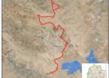
Road # 45 is not an innovative idea to work out the transportation and access problem for the Palestinians and the Israelis. More than that, the road did not come to comply with the newly coerced alteration done by Israel in the occupied Palestinian territory particularly in East Jerusalem. The first plan for road # 45 appeared back in 1996 and 1997 with similar concept, to grab all available Palestinians' lands with minimum or no population by constructing that road that will act consequently as a separation line between the Palestinians and their lands. Later on when the Segregation Wall in the occupied territory started to take shape and the plans to take in Jerusalem and annex Ma'ale Adumim settlements' bloc the former Israeli Prime Minister Ariel Sharon, suggested and planned to construct the road # 45 to incorporate within the route of the Segregation Wall to enable Israel to build more Illegal settlement around the city of Jerusalem and to tightening the grip around the city, cutting it off from the West Bank, while allowing the Palestinians to travel through an access road between the southern and northern parts of the West Bank without territorial contiguity. See Map 1
Map 1: Jerusalem Governorate & the proposed road
The same plan with minor to no adjustment is now adopted by the current, Israeli Government Headed by Ehud Olmert, as it will serve the interest of Israel, as follows:
1. Alleviate the Israeli traffic jam and facilitate the Israeli settlers' movement from Ma'ale Adumim settlements' bloc (population 40,000+) to the city of Jerusalem and consequently with Israel.
2. To create a highway to connect the Illegal Israeli settlements' bloc of Matteh Benyamin north and northeast of Jerusalem with the city of Jerusalem and with Israel.
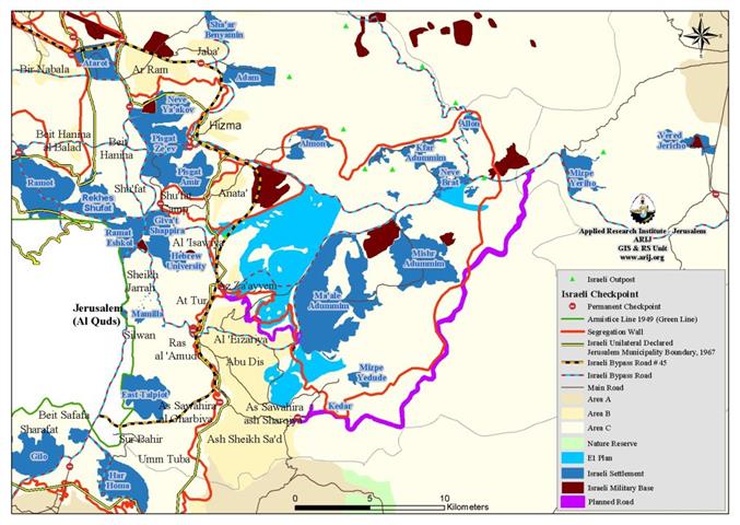
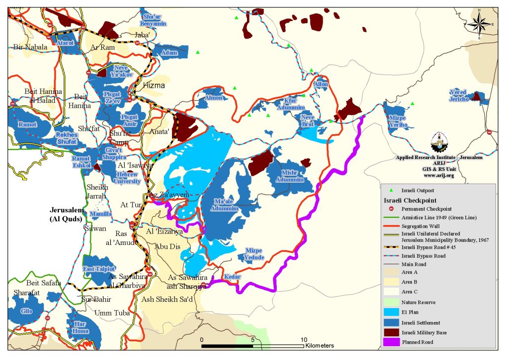
3. Consolidate the Israeli colonial plan to annex the Israeli settlements' bloc of Ma'ale Adumim East of Jerusalem, toward the Israeli jurisdiction with least number of Palestinians as possible. In this case the road # 45 will include some 12,468 dunums belong to Palestinians, and will be used to construct the E1 plan (3,500 housing units) between Ma'ale Adumim and the city of Jerusalem,
4. Persuading the United States and the International Community that Israel is keen on the geographical contiguity of the future Palestinian state, and the road # 45 is the magical solution that will guarantee the viability and territorial contiguity of the proposed Palestinian state. However, the fact is that Israel by constructing this road is misleading the whole world and imposing facts on the ground by land to develop the E1 area and deprive the Palestinians from their legitimate rights to use their lands on one hand and to their future state capital on the other.
It is evident that the under construction Israeli road # 45 is another Israeli tool to serve the Israeli colonial purposes and to impose facts on the ground, and control Palestinians movement between the southern and northern parts of the occupied territory and more importantly to isolate occupied East Jerusalem from the rest of the Palestinian territory and keep it under Israeli jurisdiction.
Recently, on October 4, 2007, Israel declared a plan for a new Israeli controlled road (highway) that will connect Bethlehem to Abu Dis area (south of Jerusalem), with Jericho. This road designated to direct the Palestinians' traffic from the Israeli traffic to the Jordan Valley area. The road, which the Israel identified as 'Fabric of life,' aims to take the Palestinians' traffic away from Ma'ale Adumim and the anticipated E1 plan. The road will be constructed in a similar manner to that of road # 45, which will include two separate pairs of lanes, one for the Israelis and the other for the Palestinians. Fore more clarification about this road, refer to the previously written case study (The Israeli Army to construct a new Road east of Ma'ale Adumim Settlement Bloc. October 22, 2007).
To Conclude
Since the first Palestinian Intifada in 1987, Israel has escalated its restriction on the movement of the Palestinian people in the occupied territories under the pretext of security and military necessities and considerations, neglecting all of the International law rules and conventions concerning the Israeli practices that violate the Palestinians' right to freedom of movement. After the eruption of the second Palestinian Intifada, which is known also as Al Aqsa Intifada in September 2000, Israel had increased the level of restrictions on freedom of movement on the Palestinians to unprecedented levels. These restrictions are a clear violation of Israel's obligations under international human rights and humanitarian law to protect freedom of movement and not to discriminate against or inflict collective punishment on the population of an occupied territory.
More over, Israel, by its ever ending Illegal practices and violations against the Palestinian people in the occupied territory, is seriously undermining all the International and regional efforts to reach a durable and final peace settlement.
Unilaterally, Israel is drawing its own map of the future Palestinian state, the state of cantons and corridors, in which there would not be any geographical and territorial contiguity, and the Palestinian people have to move through the Israeli controlled roads and territory, including access to their future capital.
Prepared by
The Applied Reserach Institute – Jerusalem