Deir Qiddis, Location and Population
The Palestinian village of Deir Qiddis is located 16 kilometers to the southwest of Ramallah city. It occupies a total area of 8207 dunums, out of which, 438 dunums makes the built-up area. The village is a home to 1968 inhabitants (PCBS 2006) most of which work in the agriculture sector.
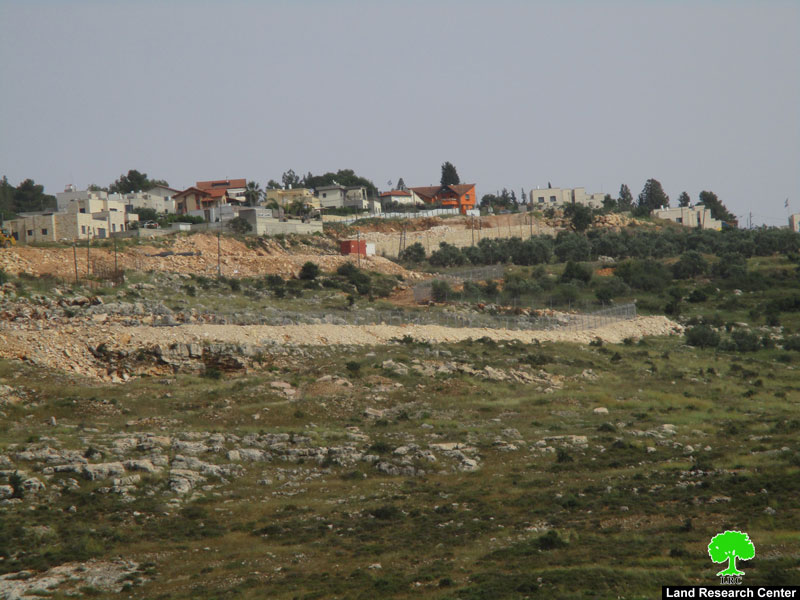
The village of Deir Qiddis is bordered by Nil'in and Al Midya villages from the west & southwest, Shabtin village & the Israeli settlements of Nili and Na'ale from the north, Kharbatha Bani Harith from the east and the Modi'in 'Illit (Kiryat Sefer) settlement Bloc from the south.
Land Classification of Deir Qiddis Village
In the Oslo II Interim Agreement that was signed in September 1995 between the Palestinians and Israelis, the Palestinian areas in the West Bank were categorized into three areas (A, B and C) which aimed at a phased withdrawal of the Israeli military forces from these areas until the accomplishment of a final status agreement.
Accordingly, the 8207 dunums of Deir Qiddis Village were classified into areas B and C; 729 Dunums of which were classified as Area B (8.9 % of the total village area) where most of the built up area of the village is concentrated; while the remaining area of the village, a total of 7478 dunums, were classified as Area C (91.1% of the total village area) and contain all the agricultural lands and the open spaces. See Table 1
|
Table 1: Classification of Lands in Deir Qiddis village according to Oslo II Agreement of 1995 |
||
|
Classification of Area |
Area |
% of the Village's total area |
|
Area A |
0 |
0 |
|
Area B |
729 |
8.9 |
|
Area C |
7478 |
91.1 |
|
Total Area |
8207 |
100 |
|
ARIJ GIS Database – 2007 |
||
The Israeli settlement activities in the village of Deir Qiddis following the 1967 war
The village of Deir Qiddis is one of the many Palestinian communities that has fallen a victim to the Israeli settlement program in the occupied Palestinian territory after the year 1967. During the period between 1980 & 1991, four Israeli settlements were partially established on lands confiscated from Deir Qiddis, they are: Nili & Na'ale settlements located to the north of the village, Mattityahu and Modi'in Illit settlements located within the Modi'in Illit settlement bloc, south of Deir Qiddis village. The Four Israeli settlements have caused the confiscation of a total 2580 dunums (2.5 km²) from the lands of Deir Qiddis village; See Table 2
|
Table 2: Israeli Settlements located within Deir Qiddis Village Boundary |
||||
|
Settlement Name |
Est. |
Pop |
Total Settlement Area (dunum) |
Area Inside village Boundary (dunum) |
|
Mattityahu |
1980 |
1360 |
683 |
21 |
|
Mod'in Illit (Qiryat Sefer) |
1991 |
30500 |
3973 |
2153 |
|
Nili |
1981 |
860 |
707 |
171 |
|
Na'aleh |
1982 |
630 |
895 |
235 |
|
Total |
|
33350 |
6258 |
2580 |
|
Source: ARIJ GIS Database 2007 |
||||
The Israeli Segregation Wall in Deir Qaddis village:-
Israel's Segregation Wall is just another oppression tool used by the Israeli State against the Palestinians and their lands. Its structure is snaking through the West Bank confiscating huge areas of Palestinian agricultural lands, confining Palestinians to small ghettos, isolating them from their lands, and altering their entire way of life.
Series of Military Orders in Deir Qiddis village for the construction of the Segregation Wall:-
The village of Deir Qiddis, like many other Palestinian villages in the West Bank, is facing the threat of Segregation and Isolation. The construction of the Segregation Wall on December 31, 2003 when the Israeli Army served the villages of Deir Qiddis with a military order number (03/106/T Judea & Samaria 2003)stating the confiscation of 381 dunums (0.381 Km2) of the village's lands for the purposes of constructing the Segregation Wall. Villagers objected the military order to the Israeli high court because the planned route of the wall will severely disrupt their lives and cut them off from natural extension areas. )stating the confiscation of 381 dunums (0.381 Km) of the village's lands for the purposes of constructing the Segregation Wall. Villagers objected the military order to the Israeli high court because the planned route of the wall will severely disrupt their lives and cut them off from natural extension areas.
On April 14, 2004, the Israeli authorities handed out villagers of Deir Qiddis another military order number (04/39/T Judea & Samaria 2004), stating the confiscation of 159.2 dunums (0.159 Km2). The new order was in fact replacing the one served in December 2003. The order isolates the village from its open space and grazing areas. ), stating the confiscation of 159.2 dunums (0.159 Km). The new order was in fact replacing the one served in December 2003. The order isolates the village from its open space and grazing areas.
On May 31, 2004, the Israeli Army served the villagers of Deir Qiddis another military order numbered (60/04/T Judea & Samaria 2004)also stating the confiscation of another area of land totaling 221.6 dunums (0.221 Km2) )also stating the confiscation of another area of land totaling 221.6 dunums (0.221 Km)
Following the latter military order in May, Israeli bulldozers commenced the constructions of the Segregation Wall in the village and started razing lands and uprooting trees. Villagers led non-violent demonstrations against the hard steel bulldozers and the Israeli Army that protected them. Villagers also resorted to legal means hoping to stop construction of the Wall on their lands and were able to obtain a court injunction to halt all works to the time the court reaches a decision.
Again, on November 11, 2004, the Israeli Army handed out villagers of Deir Qiddis a fourth military order holding number (04/84/T Judea & Samaria 2004) to confiscate 103.3 dunums (0.103) of agricultural lands from the village. The consequential of the order is that it deprives the villagers of Deir Qiddis from accessing considerable areas of their agricultural lands once the Wall is completed, See Table 3 ) to confiscate 103.3 dunums (0.103) of agricultural lands from the village. The consequential of the order is that it deprives the villagers of Deir Qiddis from accessing considerable areas of their agricultural lands once the Wall is completed,
|
Table 3: Israeli Military Orders served to Deir Qiddis Village in less than one year(Between December 2003 and November 2004) |
||
|
Date Issued |
Military Order No. |
Area Confiscated
|
|
December 31, 2003 |
(03/106/T ) |
381
|
|
April 14, 2004 |
(04/39/T ) |
159.2
|
|
May 31, 2004 |
(60/04/T) |
221.6
|
|
November 11, 2004 |
(04/84/T) |
103.3
|
Source: ARIJ GIS Database 2007
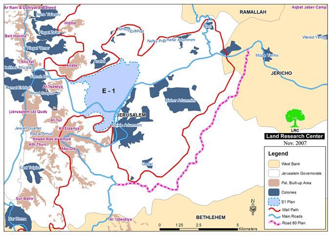
On April 30, 2006, The Israeli Ministry of Defense issued on its electronic website an updated map of the Israeli Segregation Wall in the West Bank. The new map that showed an alteration to the Segregation Wall route in the West Bank had no significance to the Palestinians other than more confiscation and complications to their lives, but served the Israeli purposes with more efficiency. The map showed that the wall is set to extend a length of 703 km on the lands of the West Bank, stretching from north to south, and will cause the isolation of 555 km square of West Bank territory.
According to the 2006 wall update, the village of Deir Qiddis were to lose 522 dunums of its lands as the wall were to extend 2.7 km across its lands, cutting the southern part of the village from the rest of the village's land. This area isolated by the Wall include parts of the Israeli settlements of Mattityahu and Modi'in Illit (Kiray Sefer). The lands confiscated by the Israeli Segregation Wall along with the lands used for construction of the Israeli settlements' comprise almost 38% of the village's total land area. See Table 4
| Table 4: LandsIsolated from Deir Qiddis Village Boundary according to April 30, 2006 Wallupdate | ||
| LandClassification of Deir Qiddis Village | Source: ARIJ GIS 2007 | % of TotalVillage Boundary |
| Area confiscatedfor construction of Bypass Roads | 736 | 9 |
| Area of IsraeliSettlements | 2580 | 31.4 |
| Lands isolated bythe Israeli Segregation Wall | 522 | 6.4 |
| AreaA | 0 | 0 |
| AreaB | 729 | 8.9 |
| Remainingof Area 'C' | 3640 | 44.3 |
| Total | 8207 | 100 |
| Source: ARIJ GIS 2007 | ||
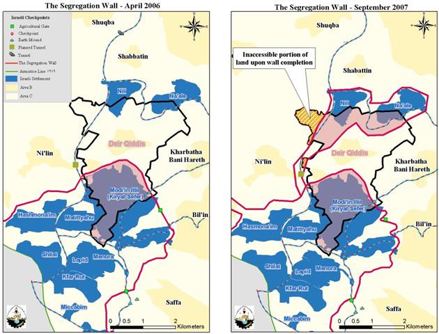
The Israeli Ministry of Defense reveals an updated map of the Segregation Wall in the West Bank
In September 2007, another update of the Segregation Wall map was published by the Israeli Ministry of Defense on its website showing new alterations to the route of the Segregation Wall in the West Bank.
As regard to Deir Qiddis Village, the updated map revealed an increase of 72.8% to the original area (522 Dunums) isolated by the Segregation Wall in 2006, as the total isolated area became 1918 dunums. In addition, the new route of the Segregation Wall showed an increase in the Segregation Wall's length by 64% from 2.7 km recorded on April 30, 2006, to 7.5 Km in 2007.
When completed, the Wall will isolate some 4498 dunums, (55%) of the village's total land area which include the settlements' area. Furthermore, the Segregation Wall will indirectly cause the isolation of an additional part (407 dunums) of Deir Qiddis village at its northwestern edge, as landowners will not be able to access it once the wall is completed. The network of Israeli bypass roads in the village to serve the Israeli settlers also confiscates a considerable area of land as shown in Table 5 & Map 1

|
Table 5: Lands Isolated from Deir Qiddis |
||
|
LandClassification of Deir Qiddis Village |
Area (dunum) |
Percent of Total Village Boundary |
|
Area confiscatedfor construction of Bypass Roads |
736 |
9 |
|
SettllementArea |
2580 |
31.4 |
|
Lands isolated bythe Israeli Segregation Wall |
1918 |
23.4 |
|
AreaA |
0 |
0 |
|
AreaB |
729 |
8.9 |
|
Additional Landconfiscated from Deir Qiddis Village Boundary |
407 |
5 |
|
Remainingof Area 'C' |
1837 |
22.3 |
|
Total |
8207 |
100 |
|
Source: ARIJGIS 2007 |
||
Deir Qiddis Village loses two thirds of its lands by the Israeli Segregation Wall
The amendments made to the route of the Segregation wall has increased the area to fall under the Israeli control in the near future to 5641, (68.7%) of the lands of Deir Qiddis Village. This increase came on the expense of the remaining available open space in the village of Deir Qiddis, currently classified as Area 'C' and is anticipated to be subject of future negotiations with the Palestinians to reclassify it to Area 'A'
Once the construction of the Segregation Wall completed, the village will stand on 2566 dunums (31.3%) of the total village area, which include the 729 Dunums classified as Area 'B' and what is anticipated to be conceded to Palestinians of Area 'C', the 1837 Dunums. This in turn will push people to sacrifice the remaining agricultural land to cope with population growth in the coming years. More than that, the population density of Deir Qiddis village, this amplifies from 240 persons per square km to 767 persons per square km.
Conclusion:-
The systematic colonization activities adopted by the Israeli government in the occupied Palestinian Territory (building settlements, constructing bypass roads and now the Segregation Wall) is considered a direct breach to the international law, including the Fourth Geneva Convention, The Hague Regulations, various human rights treaties, and UN Security Council resolutions.
The construction of the Segregation Wall results in the violation of human rights including constraining the right to freedom of movement, religious freedoms, right to work, to health, to education, and to an adequate living conditions. The ICJ decision upholds the right to self-determination of the Palestinian people,which they are denied by the Wall's disruption of the territorial integrity and unity of the population.'Self-defense' or 'state of necessity' can not be used as justification for violating these rights and other international legal principles and therefore Israel must cease constructionand all other states must refrain from supporting Israel in building the Segregation Wall.
Reference:
1. ARIJ Geographical Information Systems (GIS) Database, 2007.
2. Palestinian Central Bureau of Statistics (PCBS 2006).
3. State Information Service (www.sis.gov.ps).).
4. The Laws and Customs of War on Land. 1907. Article 46
5. [1] International Covenant on Civil and Political Rights
6. [2] supra note 1, para. 129
7. [3] International Covenant on Economic, Social, and Cultural Rights and the United Nations Convention on the Rights of the Child
8. [4] supra note 1, para. 118
9. [5] supra note 1, para. 122
10.[6] supra note 1, para. 142
11.[7] supra note 1, para. 145 , para. 145
12.[8] supra note 1, para. 146 , para. 146
::::::::::::::__
[1] Area A constitutes the areas where the Israeli army has pulled out fully and Palestinians have complete autonomy over administrative and security issues. Area A, according to the Oslo II agreement, covered the main cities of the West Bank, except for Hebron. In Area B, Palestinians have full control over the civil responsibilities and Israel continues to have overriding responsibility for security; while Area (C): Palestinians have responsibility for civil life such as economics, health and education; however, Israel retains full control over security and administration related to territory.
Prepared by
The Applied Reserach Institute – Jerusalem