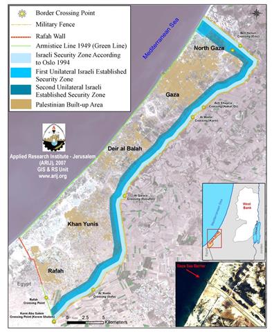
On June 28, 2007, Israeli sources revealed that the Israeli Army would mark the security zone to 1.5 km width on the Palestinian side along Gaza’s northern and eastern borders. The security zone stretches from the Mediterranean Sea shores at Gaza’s northwest to Rafah crossing border at the southeast of Gaza. An analysis conducted by the Geo-Informatics department at the Applied Research Institute-Jerusalem (ARIJ) concluded that the new adjustment to the security buffer zone would consume yet an additional 26 km² along the northern and eastern border of the Gaza Strip. The entire security buffer zone is to be cleared of any Palestinian structure.
This security zone was originally designated to a 5 Km width back in 2005, at the time when the Israeli Army have taken the Israeli settlers out of Gaza and strategically redeployed the locations of the Israeli Army around Gaza. Accordingly, the Israeli Army would have demolished several thousands of Palestinian houses within two communities north of Gaza, Beit Hanoun and Beit Lahyia. Moreover, additional sections of these two communities would have been cut off from the rest of the Gaza Strip. However, the Israeli Army did not go through with the five Km plan, instead, it withdrew from Gaza with some adjustment to the security buffer zone.
'Israel's No-Go Zone':–
In December 2005, just few months after the Israeli Army’s redeployment in the Gaza Strip, the former Israeli Prime Minister Ariel Sharon ordered the Israeli Army to establish a no-go zone for Palestinians along Gaza’s northern border, where Palestinians are not allow to access without Israeli authorization. The no-go zone would was establish across 6 kilometers long stretching from the Mediterranean Sea to Erez Border crossing and a width ranging from 2-3 km. The security zone also includes the locations of three evacuated Israeli settlements Dugit, Nisanit and Eli Sinai. By the end of 2005, the Israeli Army secured a security buffer zone around Gaza’s northern and eastern borders of 61 square kilometers; some 17% of Gaza came under full Israeli Control.
The History of Gaza's Security Zone
The security buffer zone along Gaza’s northern and eastern border came as a part-clause of the 1994 Oslo Accord, under which, the Israelis were to maintain a 0.5 Km wide security zone across the northern and eastern Gaza’s 58 Km border. This security zone occupied 29 Km2 (8%) of Gaza’s area to remain under the Israeli Army’s control.
When the Palestinian second Intifada broke out in September 2000, the Israeli Army expanded the area of the security zone unilaterally by few hundred meters (width ranges between 0.8 and 1.30 km). The area became off limit to Palestinians to build, cultivate, or just be there. By the time the Israeli Army completed their redeployment in Gaza by the end of 2005, the security buffer zone area stood at 61 Km2 (17%) of the Gaza Strip area under the Israeli Army occupation.
In June 28, 2007, and in a unilateral step, the Israeli Army expanded the security buffer zone along Gaza’s northern an eastern border to 1.5 Km width. Accordingly, the newly defined security buffer zone, occupy an area of 87 Km2 (24%) of the Gaza Strip area. The following table shows the timeline of the Israeli security zone around Gaza’s border.
|
Timeline of Israeli security buffer zone around Gaza’s Border |
|||
|
Status in years |
Buffer zone Width along 58 Km |
Area in Km2 |
Percentage of Gaza’s area |
|
1994* |
500 m |
29 |
8 |
|
Sept- Dec 2005** |
800-1300m |
61 |
17 |
|
June 2007** |
1500m |
87 |
24 |
* Agreed upon in Oslo 1994
** Unilaterally carried out by Israel

Map 1: Buffer Zones in the Gaza Strip
Terminals/ Crossings points around Gaza
At the time the Israeli completed their redeployment around Gaza, the Israeli Army controlled 6 of the seven terminals/ crossing points surrounding Gaza, except Rafah, where the Israeli had semi-control through surveillance cameras but the crossing terminal was operated by an international force and Palestinian security force. The seven crossings are:
-
Beit Hanoun crossing (Erez), located at the northern part of the Gaza Strip. It mainly serves to control Palestinians’ individuals (with Israeli issued permits) and products flow in and out of Gaza to the occupied West Bank Territory and to Israel.
-
Ash Shajaieh (Nahal Oz fuel terminal): located at the eastern border side of Gaza and is restricted for Liquid fuels imports into the Gaza Strip.
-
Al Mintar (Karni goods crossing – trade passage): located at the eastern border side Gaza and is considered the main passage for goods (in and out of Gaza to/from the west Bank and Israel.
-
Al 'Awda crossing (Sufa crossing): It is located at the southeastern border of Gaza and is only used for the imports of construction materials from Israel to the Gaza Strip.
-
Al Qarara crossing (Kesufim): Located east of Al Qarara Town, north of Khan Yunis Town.
-
Rafah Border: it is located at the southern part of the Gaza Strip and is the only passage leading to Egypt. It mainly serves Palestinians coming out and getting into the Gaza Strip. It is also used as a gateway for imports from Egypt to the Gaza Strip.
-
Karm Abu Salem crossing (Karem Shalom): it is located at the southern part of the Gaza Strip at the Egyptian – Israeli borders. It is a temporary terminal for the import of goods from Egypt and occasionally used as a crossing point. See Map 1
Gaza Sea Barrier
On June 18, 2005, Israel announced a plan to build an underwater barrier that will to start off at the Gaza’ shore northwest of the strip toward the sea. By September 2005, the Israelis completed the work on the sea barrier, which extends for 950 meters; the first 150 meters of which visiable to the eye, as for the remaining 800 meters, it went 1.8-meters-deep below the surface with floating fence.
To conclude
Israel distracted the world with its unilateral disengagement (redeployment) plan and in the mist of world applause, Israel javelin its artillery deep amongst Palestinian civilian areas and consequently making the northern part of Gaza and the entire Gaza Strip for that matter hostage to their will. The Gaza Strip is literally reoccupied by Israel; as they control the ground exists, the sea outlet the sky and with the Israeli settlements evacuated from the Gaza Strip, the Israeli Army has even more extended latitude to hit the Palestinians even harder than ever before.
The continued Israeli manipulation of the peace process is a major source of the upsets that over shadowed the peace process as the Israeli political establishment continues to elude its duties and responsibilities to the peace process and deny Palestinians of their manifested right as conceded in the 'Madrid' and 'Oslo Accord' for a guaranteed independent, occupation free State of their own within an agreed time frame.
Prepared by
The Applied Research Institute – Jerusalem
ARIJ