Introduction about Far'on:
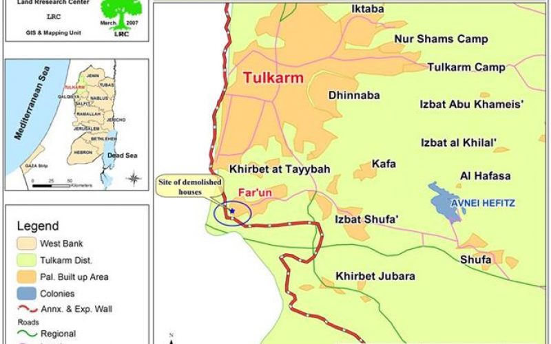
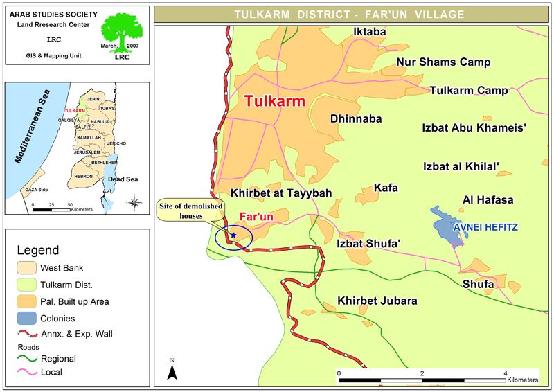
The village of Far'on is located north of the city of Al Tayeba in the Triangle near the Green Line and south of the Governorate of Tulkarem. It is 3 kilometers away from the city of Tulkarem with an area of 8,000 dunums. Its population is about 3,500 most of whom work in agriculture as more than 70% of the villages' lands are planted with olive and almond trees. The affairs of the villages are run by a village council. It has a sports club, a clinic, two pharmacies, kindergartens, one high school for girls and an elementary school for boys. The refugees constitute 25% of the population of the village. The current surface area of the village has contracted from 8,000 dunums to 4,000 due to the erection of the Israeli Racist Isolation Wall.
Far'on's Economy:
The three main components of the economy of the village are:
-
Agriculture: Most of the population of the village (around 70%) works in this field due to the high fertility of the lands of the village. The cultivated lands cover an area of 4,000 dunums of which 60% are currently located beyond the Wall.
-
Commerce: Due to the close proximity of the village to the Green Line, the village had become a trade center with Arab cities and towns inside the Green Line such as Tayba and the Triangle. The erection of the Wall has destroyed the trading business almost completely.
-
Workforce: Around 90% of the workforce in the village used to work inside of the Green Line. When the Wall was established, unemployment became rampant in the village.
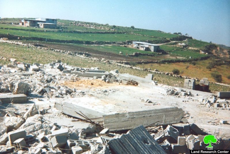
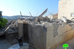
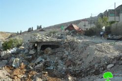
House Demolishing:
Israeli occupation forces demolished on Thursday the 22nd of February, 2007, six housing units in the village under the pretext that they were built close to the Isolation Wall. The units belonged to the following:
-
Fareed Abdel Jabbar
-
Mufeed Kamel Budeir
-
Mahmoud Abdulla Salem
-
Shaker Mahmoud Budeir
-
Ammar Zaki Arafat
-
Riyad Ismaeel Omar
The lawyer hired by the village council and house owners, Mr. Fathi Shubeitah, indicated that the ghost of demolishing will continue to haunt the village and its inhabitants due to the following reasons:
-
Most of the housing units are located only 500 meters away from the Green Line. When the Israeli occupation government erected the Wall, most of the houses became adjacent to it despite the fact that these units were built in 1998, at least 4 years before the establishment of the Wall.
-
These units were built on agricultural lands, not on lands reserved for building purposes.
-
These units lie outside of the boundaries of the Master Plan of the village which won't be expanded until the year 2015.
-
They are too close to the Green Line.
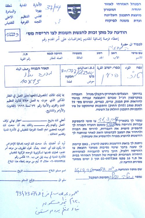
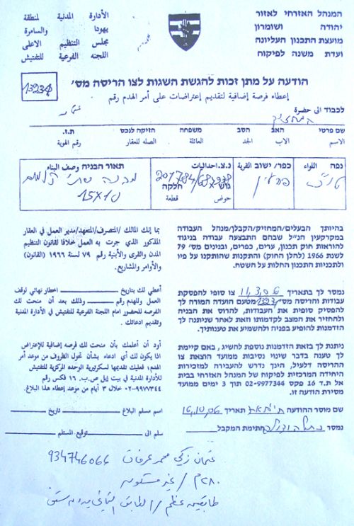
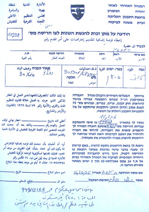
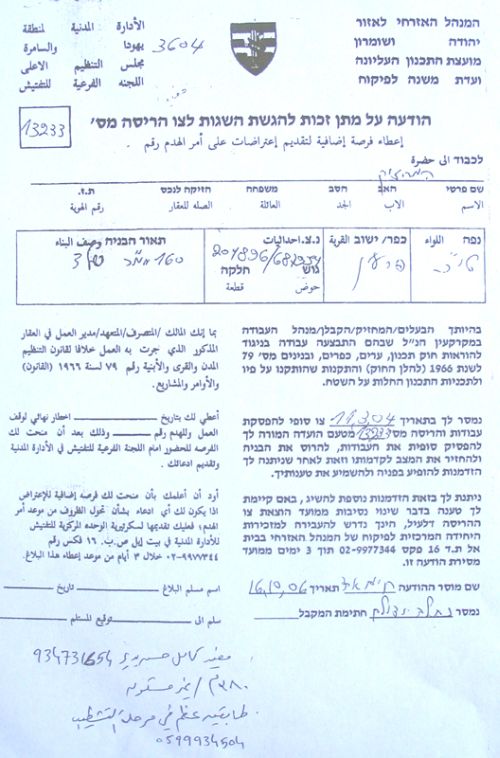
In addition to the demolishings, Israeli occupation forces distributed on February 9th, 2007, a set of demolishing and 'stop construction' orders in the western and southern parts of the village. Some owners received, also, orders to meet the Regulation Section in Bet El on March 4th, 2007. The following table details the affected Palestinians with these orders:
|
No. |
Name |
No. Family Members |
Inhabited |
Building |
|
1 |
Husam Saleem Hasan A'asi |
2 |
Yes |
1st floor � Ready |
|
2 |
Bassam Saleem Suleiman |
3 |
Yes |
2nd floor � Ready |
|
3 |
5 |
No |
Unfinished |
|
|
4 |
4 |
No |
Unfinished |
|
|
5 |
6 |
No |
Two stories – Unfinished |
|
|
6 |
7 |
No |
Two stories � Unfinished |
|
|
7 |
6 |
No |
Two stories � almost ready. |
|
|
8 |
Munir Abdullah Omar |
7 |
Yes |
Two stories � Ready |
|
9 |
5 |
No |
Two stories � Ready |
|
|
10 |
Imad Salman Hazahza |
4 |
Yes |
Two stories � 1st finished |
|
11 |
Basem Tayseer Moh'd Awad |
4 |
Yes |
Ground floor � Ready. |
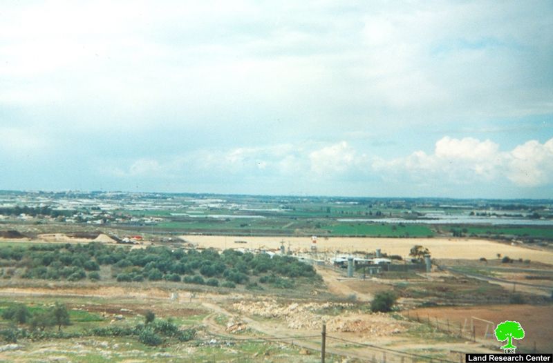
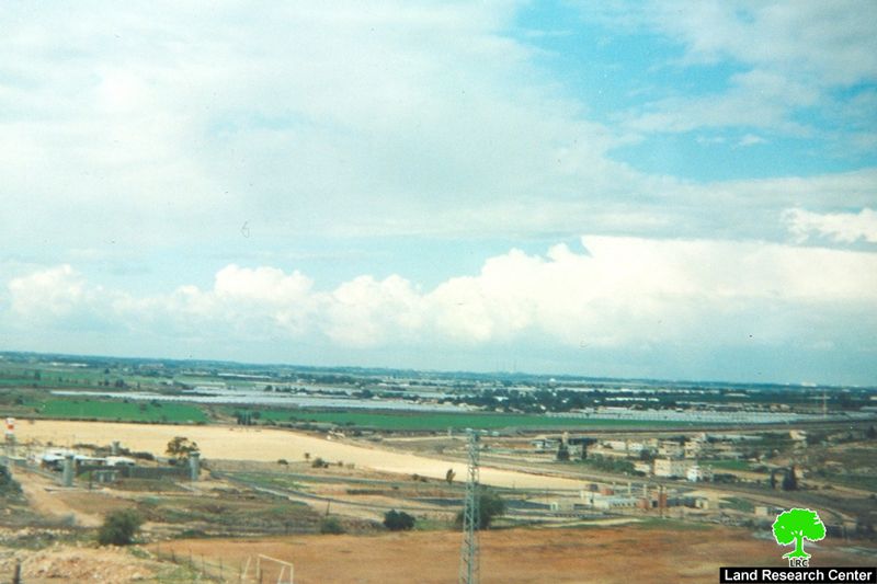

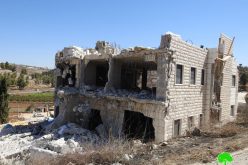
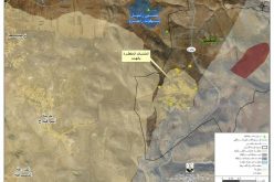
The Israeli Racist Isolation Wall:
The length of the Israeli Wall cutting through the lands of the village is about 5 kilometers and it isolates around 4,000 dunums (which amounts to about %50 of the total area of the village) behind it. The Wall was established atop 200 dunums planted with olive trees. In addition, the Wall have, so far, caused the demolishing of 5 houses and left 40 people (mostly children) homeless. Another 11 houses are under the threat of being demolished under the pretext of being too close to the Wall and its route. That is despite the fact that most of them were built before the establishment of the Wall and that some of them are as far as 300 meters away from the Wall. If such demolishings take place, at least 53 people will become homeless.
Negative Affects of the Racist Wall on the Village:
-
The psychological effects: increased incidents of social fights and disagreements between village members due to a general feeling of depression and boredom generated by the lack of access and movement.
-
The educational effects: Increased difficulties faced by students trying to reach their universities in nearby cities. In addition, the difficult economical situation led to decreasing the number of families willing to send their sons and daughter to universities.
-
The economical effect: The confiscation of more than 50% of the lands of the village and the deprivation of more than 400 farmers from their only source of income have deeply affected the economy of the village 40% of which depends on agriculture. Such confiscations led to a sharp decrease in the income of the farmers especially that most of their olive tree-filled lands have become isolated beyond the Wall. Moreover, the construction of the Wall led to the decrease in the amount of water reaching the village (for agricultural purposes) in addition to making markets unreachable. In order for the farmers to reach their lands located in the so-called 'seam zone', they need to get an agricultural permit from the Israeli authorities. No permits are issued for cars, vehicles or tractors which makes working in the land a virtual impossibility. Moreover, there are more than 300 day workers who used to work inside of Israel but are unable currently to reach their work stations. In short, the economical situation in the village is depressing.
-
The environmental effect: There is a garbage dump site that belongs to the Tulkarem municipality 2 kilometers east of the village. Other dumpsites in the village were isolated behind the Wall which made the residents use the municipality dumpsite at an increased frequency. Such a usage led to the increase of the surface area of the site and the seeping of the liquid trash concentrate into the groundwater. Water and well contamination of the nearby wells resulted.
-
The social effects: Since working on the establishment of the Wall, Israel has destroyed the social fabric of Palestinian life through not allowing family visitations or forcing Palestinians to move from villages and towns that are close to the Wall to other towns that are not. For example, there are more than 40 Palestinians living in the village whose spouses are from the Triangle area inside the Green Line. The Wall has prevented mutual family physical visits between these families. The only methods of communication are either through the telephone or through the gates in the Wall (which requires a special permit � difficult to be issued). Such a fact led to the separation between spouses on a number of occasions.
-
Unemployment: About 90% of the workforce of the village depended on working inside the Green Line. Most of them left their work due to the inability of reaching their workplace without proper permits. Such a fact led to the increase of the unemployment rate in the village to 75%.
Latest Development in Wall Construction:
-
All Wall-related work has been finalized from the section between the new Irtah checkpoint to the area of J'bara. The Wall in this section consists of barbwires followed by a 7 to 10 meter long ditch with a depth of 3 to 4 meters. It is followed by an un-rehabilitated road with a width of 20 t0 25 meters. A 50-100 meter tall cemented wall with barbwires follows after which a 20-25 meter rehabilitated road is placed. At a distance of 5 meters away from the rehabilitated road the Israelis placed additional barbwires.
-
Currently plowing and land leveling are taking place behind the Wall in the western side of the village for unknown reasons. A number of prefabricated rooms have been placed in that region and it is expected to be used for settlement purposes.
Facets of Palestinian Suffering Due to the Wall:
-
Difficulties in transporting the agricultural produce from the village into the Green Line due to the lack of vehicular permits.
-
Settler attacks against Palestinian farmers while working in their fields.
-
The rejection of issuing permit despite numerous attempts.
-
Waiting in long lines at checkpoints.
-
In cases of total closures, no Palestinian is admitted into Israel even if they carry with them a valid permit.
Security Measures and their Effects:
-
There are two checkpoints/gates (Irtah and J'bara) on the Wall surrounding the village.
-
Taiba checkpoint was relocated to the Irtah location.
-
An additional checkpoint will be added upon the finishing of the Wall.
-
The agricultural gate located west of the village was not opened for the past two years due to the lack of permit which led to devastating the agricultural seasons for two consecutive years.
-
In 1989 a 2-kilometer long settlement road was established which led to preventing foot access of Palestinians to their lands. The road is located west of the Wall at a distance of about 400 meters away from it.
Prepared by
The Land Research Center
LRC


