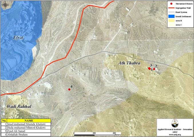
The reason stated in the demolition notices is that the residential houses were built in area C (where Israel has complete control)and without acquiring permits from the Israeli civil administration of Beit El in Ramallah; even though the owners of these threatened houses have legal building permits issued from the municipality of Bethlehem, being the official Licensing Authority for that area. See map 1.
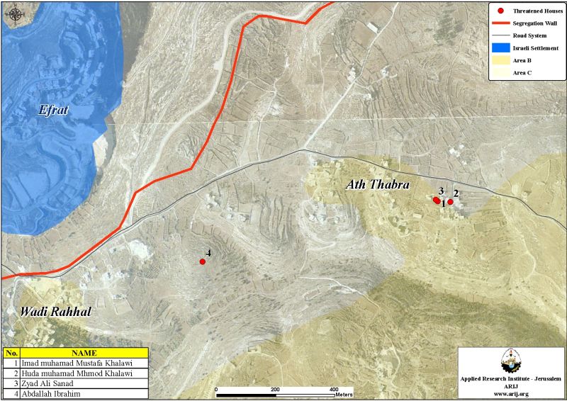
In the notices served by the Israeli Army, the Palestinian owners of the threaten houses were allowed a grace period to put forward the objections to the demolish notices; set at February 22, 2007.
This is not the first time that Palestinians from Wadi Rahhal served with demolish notices, some dozens similar orders were issued by the Israeli Army over the past few years under the same pretext over and over again.
Previous acts of demolitions in Wadi Rahhal village:
Prior to the recent issued demolishing notices, several structures in Wadi Rahhal were subject to demolishing by the Israeli Army, also under the same pretext of building without license. The following table 1 lists the demolishing with relevant details:
Table 1: Structures demolition in Wadi Rahhal before 2000
|
Owner's name |
Type of structure |
Area in M2 |
Pretext for demolition |
|
Muhammad Khalil Khalawi |
House |
75 |
Built without license |
|
Khalil Mohammad Khalawi |
House |
85 |
Built without license |
|
Kamel Khalawi |
House |
100 |
Built without license |
|
'Abed Abed Allah Hjazi |
Saw |
200 |
Built without license |
|
Mahmud Abed Al Hammed |
90 |
House |
Built without license |
|
Abed Allah Khaddar Ziyada |
Agricultural Room |
NA |
Built without license |
Table 2: Demolition of other structures in Wadi Rahhal after 2000
|
Owner's name |
Type of structure |
Area in M2 |
Pretext for demolition |
|
As' ad Mohammad Ismael Al Fawaghrah |
House |
280 |
Built without license |
|
Walled Mohammad Judah Abu 'Ahour |
House |
100 |
Built without license |
|
Abed Allah Khaddar Ziyadah |
Barrack |
150 |
Built without license |
|
'Issa Ali Ismael |
Agricultural Room |
30 |
Built without license |
|
Ahmad Ibrahim Abed Allah |
Room |
35 |
Built without license |
|
Jamal Ahmad Ismael Khalawi |
Infrastructure for the house |
NA |
Built without license |
|
Ghaleb Abed Ibrahim |
Infrastructure for the house |
NA |
Built without license |
The village of Wadi Rahhal: (location & population)
Wadi Rahhal village (built-up area 114 Dunums, population 570 inhabitants, PCBS 2006) is located some 4.9 km east of the 1949 Armistice Line (the Green line) and about 5.5 km to the southwest of Bethlehem city. It is part of Al Khaddar villages cluster (20090 Dunums-(Al Khader, Wadi Rahhal, Khallet 'Afana, Wadi an-Nis and Jurat ash Sham'a). The following table 2 list Al Khaddar villages cluster landuse/ landcover:
Table 2,Land Use/ Land Cover Classification within Al Khader villages cluster:
|
Land use / land cover |
Area / Dunums
|
|
Arable land
|
2819
|
|
Forests
|
49
|
|
Heterogeneous agricultural areas
|
3223
|
|
Industrial, commercial and transport unit
|
19
|
|
Open spaces with little or no vegetation
|
1971
|
|
Pastures
|
119
|
|
Permanent crops
|
2062
|
|
Plastic Houses
|
3
|
|
Shrub and/or herbaceous vegetation associations
|
5662
|
|
Palestinian Built-up area
|
1245
|
|
Israeli Settlements
|
2917
|
|
Total |
20090
|
Source: ARIJ GIS Database 2006
Israeli settlements established within Al Khaddar villages cluster:
There are six Israeli settlements established in Al Khader villages cluster, which occupy an area of 2933 dunums (14.6 %) from its 20090 Dunums land area. The following table 3 shows the status of the established six settlements.
Table 3: List of Israeli settlements constructed within Al Khader villages cluster
|
Israeli Settlement
|
Date of Establishment
|
Population 2004
|
Settlement Area inside village Boundary – 2005 (Dunums)
|
Total settlement Area – 2005
|
Location To Wadi Rahall |
|
Rosh Zurim
|
1969
|
298
|
4
|
893
|
West |
|
Allon Shevut
|
1971
|
3229
|
38
|
1003
|
Southwest |
|
Migdal Oz
|
1977
|
313
|
46
|
1133
|
Southwest |
|
Neve Daniyyel
|
1982
|
1225
|
584
|
584
|
Northwest |
|
Elazar
|
1975
|
993
|
542
|
542
|
West |
|
Efrat
|
1979
|
7273
|
1719
|
2190
|
West |
|
Total |
|
13331
|
2933
|
6345
|
|
Source: ARIJ GIS Database 2006
Furthermore, between the years 1996 and 2004, five Israeli settlements’ outposts were established on lands within Al Khader villages cluster. Table 4 lists these outposts with available details:
Table 4: Israeli settlement outposts established on lands within Al Khader village cluster
|
Mother Settlement |
Number of structures |
Outpost Name |
Date of Establishment |
State of Outpost |
|
Elazar |
22 |
Derech Ha'avot |
Feb 2001 – Nov 2002 |
Outpost |
|
Neve Daniyal |
2 |
Neve Daniyal North |
Feb 2001 – Nov 2002 |
Inside colony border 2001 |
|
Neve Danyiel |
12 |
North Neve Danyiel |
1996- Feb 2001 |
Outpost 2000 |
|
Efrat |
17 |
West Efrat |
2002 – June 2003 |
Inside Colony Border 2003 |
|
Neve Danyel |
3 |
North Neve Danyel |
June 2003 – Jan 2004 |
Outpost |
Source: ARIJ GIS Database 2006
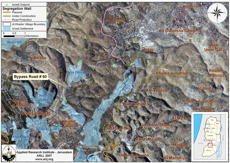
The Segregation Wall piercing Al Khader villages cluster:
According to the April 30, 2006 Segregation Wall plan, the length of the Segregation Wall that runs through Al Khader Village's cluster lands stretch for 6.8 Kmfrom the north to the south and will accordingly isolate thousands of Dunums; including, Palestinian agricultural lands and open spaces areas behind the Segregation Wall.
Once the construction of the Segregation Wall is completed; it will isolate 15390 dunums (76.6 %) of Al Khader villages cluster’s lands, which includes the settlements areas. Table 5: shows Landuse/ Landcover of Isolated Lands west of the Segregation Wall within Al Khader villages cluster.
|
Isolated Landuse Landcover 2004 type for El Khader Village Boundary
|
Area in Dunum
|
|
Arable land |
1764
|
|
Forests |
39
|
|
Heterogeneous agricultural areas |
2894
|
|
Open spaces with little or no vegetation |
1416
|
|
Pastures |
119
|
|
Permanent crops |
1536
|
|
Shrub and/or herbaceous vegetation associations |
4666
|
|
Palestinian Built-up area |
40
|
|
Israeli Settlements |
2916
|
|
Total |
15390
|
Source: ARIJ GIS Database 2006
Bypass Roads:
The Israeli bypass road number 60 stretch a length of 6.852 km to break Al Khader villages cluster, separating the village from its agricultural lands. On December 15, 2005, an Israeli military order holding number (No. 34) 5727-1967 was issued to restrict Palestinian movement on bypass roads and even though the order is not completely operational, it will eventually cut of Palestinians of Al Khader villages cluster from accessing their lands, particularly when the construction of the Israeli Segregation Wall along the bypass roads 60 is completed. See map 2.
Conclusion
Israel’s policy of house demolitions in the Occupied Palestinian Territory seeks to confine Palestinians to small enclaves and separate them from their agricultural lands and areas set for future development of the built-up areas.
According to the Fourth Geneva Convention Israel as an occupying power is prohibited to demolish Palestinian houses as stated in Article 53 of the Convention which states that: 'Any destruction by the Occupying Power of real or personal property belonging individually or collectively to private persons, or to the State, or to other public authorities, or to social or cooperative organizations, is prohibited, except where such destruction is rendered absolutely necessary by military operations.
Prepared by
The Applied Research Institute – Jerusalem
ARIJ