A repository of the trash where Israeli settlers get rid of their garbage is arousing peoples' concern in the village of Jayyus in the West Bank due to its harmful effects on health and environment. The garbage depot is located on a hill where the only available water well is located at the base of that same hill.
In an interview with Reuters TV, the head of Jayyous village council, Shawkat Samha, said to that regard the damping site is used by a number of nearby settlements in the area to dispose of the chemical materials over the past two decades, causing unidentified health and environmental hazardous in the area, which negatively affected human health, agriculture and environment. Furthermore, Jayyus residents emphasized the acts of residents of the Israeli Zuffin settlement who deliberately dump their garbage on the agricultural lands of Jayyus residents, causing severe damages to the Agricultural crops.
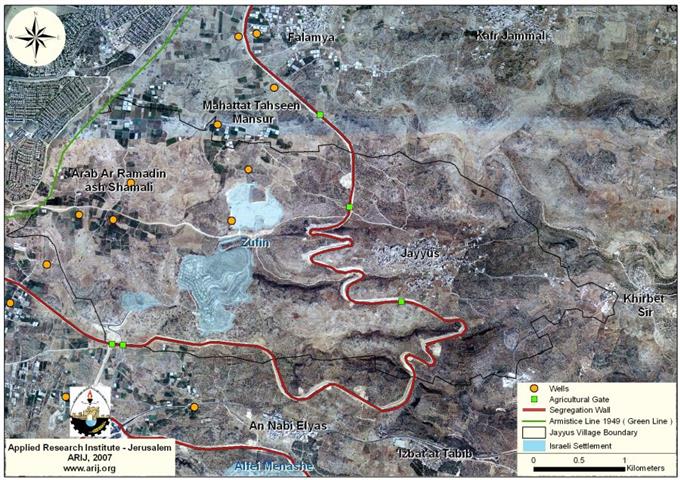
Furthermore, the head of Jayyus village council added that when the Segregation Wall section running near their village was completed, they no longer were able to get hold of the village's water resources, which are now located west of the Segregation Wall beyond their reach. Six artesian wells located on Jayyus lands and used domestically by the village residents are no longer available to the residents who are now compelled to acquire their needed share of water from nearby Azzun village well, which is located some 300 meters away from the deposit site and its down the hill which means that there is a good chance that the poisonous chemicals waste could leak to the underground water, particularly in the winter, while the material that do not takes on the Olive trees in the surrounding fields.
South of Qalqilyia governorate, in a valley where the village of Beit Amin is located, the residents, and those of nearby villages (Izbat Salman, Al-Mudawwar, IzbatAl-Ashqar, Sanniriya) has two water wells that provide the residents with their needs, however, increasing dumping of waste water from the surrounding Israeli settlements, particularly from Shaare Tikva settlement. Mohamed Sa'ed, a member of Beit Amin village council, stated in an interview with Reuters that the Israeli dumping has transformed Beit Amin valleyfrom being a rest for wild plants and birds' nests into a highly polluted area, with stream of waste and swage water flows at the bottom of the valley.
Location & Population of Jayyus and Beit Amin Villages
The village of Jayyus (population 3307 inhabitants) is located about 4.99 km of the 1949 Armistice Line (Green Line) and about 6.14 Km from Qalqiliya's city northeastern side. The total area of Jayyus village boundary is 12,600 dunums, of which 344 dunums are Palestinian built up areas. Jayyus has the most fertile agricultural lands in the area and its products represent substantial share of the fruits and vegetables basket for the West Bank.
Israeli settlements established on Jayyus lands
In 1989, the Israeli Army supported Israeli settlers to start up a settlement on lands confiscated from Jayyus village. The land seized for this purpose are located west of Jayyus village, some 621 Dunums were appropriated to establish what is known today as Zuffin settlement. In 2004, the settlers of Zuffin expanded the boundary of the settlement and confiscated an additional 219 Dunums for that purpose location of the settlement.
The Segregation Wall in Jayyus village
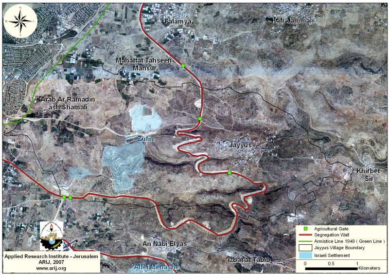
The Segregation Wall in Jayyus village was among the first sections to be completed in the West bank territory. It extend across Jayyus lands for 7.5 Km east of the Green Line and segregate some 8089dunums (64.2%) of Jayyus lands behind it, including the 840 Dunums where Zuffin settlement stands. More than that, the isolated lands has more than 33 greenhouses, and more than 15,000 citrus trees, which no longer became accessible to Jayyus farmers who were denied access to their groves and were unable to tend the trees, which consequently reflected negatively on the Palestinian residents', as 75% of the them depend on agricultural sales for their livelihood. The Israeli Army has designated two agricultural gates on the Wall for the farmers to access their lands, if they are in possession of special permits issued from the Israeli civil administration. The Israeli Army has made clear to the farmers, that the agricultural gates will be open three times a day unless the security update decides otherwise and the timing is controlled by the Israeli Army as well.

The village of Beit Amin (population 1147inhabitants)is located about (3.36 km) of the 1949 Armistice Line (Green Line) and about (7.87 Km) from Qalqiliya's city southeastern side. It is part of the Sanniriya villages cluster (13269 Dunums-(Sanniriya, Beit Amin and 'Azzun 'Atma).
Israeli settlements established within Sanniriya villages cluster
The Israeli settlements started early within Sanniriya cluster back in 1977 and five Israeli settlements where established since then. The five Israeli settlements occupy an area of 4740 Dunums, of which, 2324 Dunums (17.5%) were confiscated from Sanniriya cluster (13269 Dunums). The following table shows the status of the established five settlements. See Table 2
Table 2: List of Israeli settlements constructed inside Sanniriya villages cluster
|
Israeli settlements
|
Date of Establishment
|
Population 2004
|
Total settlement Area 2005/Dunum
|
Area-2005 Inside Sanniriya cluster/ in Dunums
|
Location from the village of Beit Amin |
|
Shaare Tikva
|
1982
|
3685
|
1062.940
|
755
|
South
|
|
Elkana
|
1977
|
2983
|
1512.810
|
77
|
South
|
|
Etz Efrayim
|
1985
|
627
|
565.880
|
165
|
Southeast
|
|
Zamarote
|
1985
|
N/A |
309.530
|
289
|
West
|
|
Oranit |
1983 |
5458
|
1288.770
|
1038
|
West
|
|
Total |
|
12753
|
4740
|
2324
|
|
Source: ARIJ – GIS Database – 2006
The Segregation Wall within Sinniriya villages cluster
According to the April 30, 2006 Segregation Wall plan, the length of the Segregation Wall that runs on Sanniriya villages cluster lands stretches to 14.130 Km, cutting off some 2678 Dunums (20+%) of the land, which include the settlements' areas. In addition to land, the Segregation Wall will isolate valuable water resources, olive, fruits and citrus groves, which will be lost as in isolated by the Segregation Wall. It is worth mentioning that the only access for the Palestinians farmers in Beit Amin and the rest of the farmers of Sanniriya villages cluster will be through the 2 agricultural gates under Israeli control, providing that the farmers obtain permits from the Israeli civil administration. See Map 2
Underground wells in Wadi Beit Amin:
There are seven artesian wells located within Sanniriya villages cluster, of which two artesian wells are in Beit Amin valley with a daily extraction capacity of 1440 M3; used for domestic and agricultural purposes. Because of the Israeli environmental disregard, much of the wastewater dumped in Beit Amin valley falls close to these wells, causing more suffering to the people of the area. See Map 3

International Status
Deliberate pollution to the environment is prohibited under the Geneva Convention of (1977), Article 55 highlight the necessity to provide Protection to the Environment:
1. Care shall be taken in warfare to protect the natural environment against widespread, long-term and severe damage. This protection includes a prohibition of the use of methods or means of warfare which are intended or may be expected to cause such damage to the natural environment and thereby to prejudice the health or survival of the population.
2. Attacks against the natural environment by way of reprisals are prohibited.
Prepared by
The Applied Research Institute – Jerusalem
ARIJ


