• About The Project
  • Palestine in Century
  • Selected Maps
  • Glossary
  • About ARIJ
  • About LRC
  • By Year
    • Case Studies By Year
    • Daily Report By Year
Friday, May 9, 2025
POICA
No Result
View All Result
  • Home
  • Settlements
    • New Israeli Settlements
    • Settlement Expansion
  • Israeli Violations
    • Agriculture
    • Confiscation
    • Demolition
    • Environment
    • Eviction of Palestinians
    • Settlers Attacks
  • Bypass Roads
  • Israeli Plans
  • Segregation
    • Checkpoints
    • Closure
    • Separation Plans
  • Military Orders
  • Reports
    • Daily Report
    • Monthly Report
    • Quarterly Report
No Result
View All Result
POICA
No Result
View All Result

Jubara and Hawara checkpoints: a barrier not a link

December 20, 2006
in Checkpoints
Jubara and Hawara checkpoints: a barrier not a link

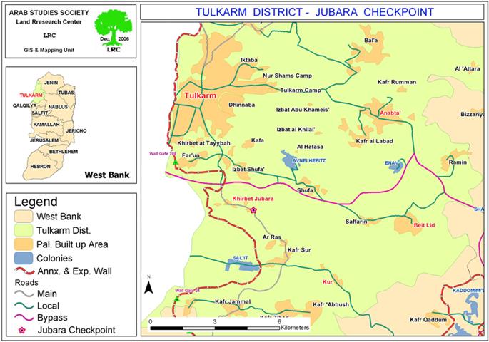
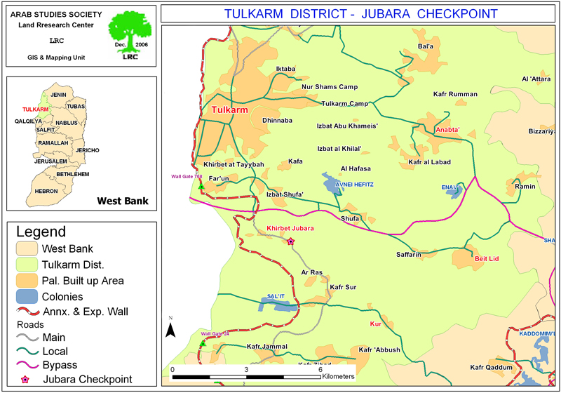
Recently, the Israeli occupation forces began to impose further complications on the Palestinian movement in and out of the city of Tulkarem through the Jubara checkpoint which is supposed to link between Tulkarem and Qalqiliya governorates, on one hand, and between the city of Tulkarem and its southern villages, on the other hand. 


At the same time, similar complications were also imposed at Hawara checkpoint in the south of Nablus. This checkpoint is located between Nablus and the southern governorate of Ramallah and Al Bira.


The two checkpoints were established as part of the Israeli separation and cantonization plan in the West Bank which aimed at dividing the Palestinian areas into separate closed cantons and controlling the Palestinian movement amongst these canton. 


 Complications at Jubara checkpoint, Tulkarem:


The Land research Center's field worker depicted the following additional complications and restrictions:

  •  Intermittent and unexpected closure of the checkpoint interrupting the daily crossing of people, of whom many are students, employees and farmers under alleged security claims. See Map 1

  • Delaying and hindering the people movement through Jubara checkpoint where sometimes those carrying the Tulkarem IDs are not allowed to pass through and they have to take more costly and length roads through Anabta town in the east, then Beit Lid in the south east, and finally through Kur village in the south before reaching the Kafriyat area. In the past the road between the Kafriyat area and the city of Tulkarem used to take not more than 15 minutes drive ( 10 km long).  Now, it needs at least one hour as passengers are obliged to travel more than 35 km through the aforementioned alternative  road route.


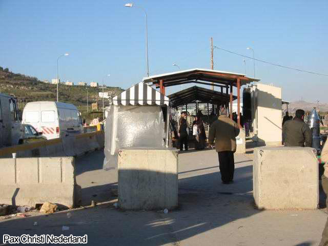
(Photo 1: people and vehicles waiting at Jubara checkpoint)

  • Although the Jubara checkpoint is an internal one separating between Palestinian governorates and has nothing to do with crossing to Israel strict and humiliating checking measures have been imposed on it, including body searching, unloading of cargos and detaining of people for long hours.

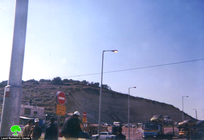
  • Introducing more watch towers and army personnel as well as additional fences and fortifications in and around the checkpoint. 


(Photo 2: a military tower overlooking the Jubara checkpoint)


Complications at Hawara checkpoint, Nablus:

The Land research Center's field worker depicted the following additional complications and restrictions:

1.     Detaining and delaying people for long hours by forcing them to stay in long queues, pass through rolling gates, uplift their clothes and carry meticulous body searches on them.

2.     Creating big congestions by allocating only two tiny walking paths for all passengers willing to cross from  Nablus governorate to Ramallah and south.

3.     Occasional opening of fire, and throwing of tear gas and sound bombs  at the waiting crowds causing, sometimes, injuries and deaths like the killing of a youth from the village of Burin at the end of last November.

4.     Forcing all car drivers ( public, private and international humanitarian ) to obtain valid passing permits from the Israeli military as a requisite for passing this checkpoint. However, not all applicants succeed to get such a permit. 

5.     Fixing more watch towers at the hills overlooking the checkpoint which resulted in the confiscation of more plots of land and deprivation of farmers and land owners from approaching these towers to tend their land. In other words, the Israeli army, by so doing,  created small  military zones inaccessible for Palestinians.   See Map 2 


6.     Establishing a new room for women's checking provided with all the  technological facilities usually seen in international border crossings despite the fact that this checkpoint is inside the occupied Palestinian territories and separates between Palestinian districts.


(Photo 3: Hawara checkpoint, Nablus


Prepared by
The Land Research Center
LRC

Recommended For You

الحرب على قطاع غزة وتأثيرها على محافظة الخليل جنوب الضفة الغربية

by arij
November 30, 2023
0

  تقع محافظة الخليل في الجزء الجنوبي من الضفة الغربية المحتلة، إلى الجنوب من مدينة القدس، وعلى بعد حوالي 36 كم منها. يحدها من الشمال محافظة بيت لحم،...

Read moreDetails

تطبيق سياسة الفصل العنصري على استخدام الطرق الرئيسية في الضفة الغربية وتقيد حركة وتنقل المواطنين الفلسطينيين

by arij
November 22, 2023
0
معاناة شجرة الزيتون الفلسطينية بسبب الاحتلال والاستيطان في العام 2023

  بناء على تقديرات مراقبين دوليين يبلغ عدد الحواجز الإسرائيلية في الضفة الغربية أكثر من 567 حاجز إسرائيلي متعددة الاشكال منها 77 حاجزًا رئيسيًا وجزئي تتحكم في حركة...

Read moreDetails

The Instigation of Apartheid Roads Era: Israel blocks Palestinian movement inside West Bank Governorates

by arij
November 22, 2023
0

  According to international observers, Israel constrains the West Bank territory with 567 various types of obstacles; 77 of which are main checkpoints and partial checkpoints that control...

Read moreDetails

Between “Ben Gavir” and Netanyahu Not Oblivious but Vindictive, The reality of Israeli Apartheid Stands in the occupied Palestinian territory

by arij
September 13, 2023
0
Between “Ben Gavir” and Netanyahu Not Oblivious but Vindictive, The reality of Israeli Apartheid Stands in the occupied Palestinian territory

  In the wake of the overwhelming Israeli settlers and the Israeli occupation government increasing their wave of attacks and assaults on the Palestinian people (more than 700...

Read moreDetails

نصب بوابة حديدية على مدخل قرية حوسان في محافظة بيت لحم

by arij
November 1, 2022
0
نصب بوابة حديدية على مدخل قرية حوسان في محافظة بيت لحم

   الانتهاك: نصب بوابة حديدية جديدة. الموقع: بلدة حوسان/ محافظة بيت لحم. التاريخ: 11/08/2022م. الجهة المعتدية: جيش الاحتلال الإسرائيلي. الجهة المتضررة: أهالي قرية حوسان والقرى المجاورة. تفاصيل الانتهاك:...

Read moreDetails
Next Post
A new Wall section at the expanse of the lands of Kafr ad Dik and Beir Ballut

A new Wall section at the expanse of the lands of Kafr ad Dik and Beir Ballut

LATEST NEWS

الأراضي الفلسطينية بين الذرائع الأمنية والأطماع الاستيطانية – “الأمن، الآثار، والطبيعة كحجج لاقتلاع الفلسطينيين من أراضيهم”

by arij
April 15, 2025
0

........................................................

الطرق الالتفافية الاسرائيلية وأثرها على البيئة الفلسطينية

انتهاك للطبيعة والهوية في الأراضي الفلسطينية المحتلة

by arij
March 17, 2025
0

........................................................

Israel Advances Settlement Plan on Ancient Olive Groves on lands of Beit Jala city, Violating International Law and depriving Palestinians their lands

إسرائيل تمضي قدمًا في مخطط استيطاني جديد على أراضي مدينة بيت جالا، في انتهاك للقانون الدولي وحرمان الفلسطينيين من أراضيهم

by arij
April 29, 2025
0

........................................................

Israel Advances Settlement Plan on Ancient Olive Groves on lands of Beit Jala city, Violating International Law and depriving Palestinians their lands

Israel Advances Settlement Plan on Ancient Olive Groves on lands of Beit Jala city, Violating International Law and depriving Palestinians their lands

by arij
April 29, 2025
0

........................................................

flag_yellow_lowEU-PfP-Logo

This website has been produced with the assistance of the European Union. The contents of this publication are the sole responsibility of ARIJ & LRC and can in no way be taken to reflect the views of the European Union.

© 2025 Copyright ARIJ . All Rights reserved. .

No Result
View All Result
  • Home
  • Settlements
    • New Israeli Settlements
    • Settlement Expansion
  • Israeli Violations
    • Agriculture
    • Confiscation
    • Demolition
    • Environment
    • Eviction of Palestinians
    • Settlers Attacks
  • Bypass Roads
  • Israeli Plans
  • Segregation
    • Checkpoints
    • Closure
    • Separation Plans
  • Military Orders
  • Reports
    • Daily Report
    • Monthly Report
    • Quarterly Report

© 2025 Copyright ARIJ . All Rights reserved. .