Archive
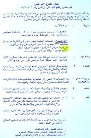
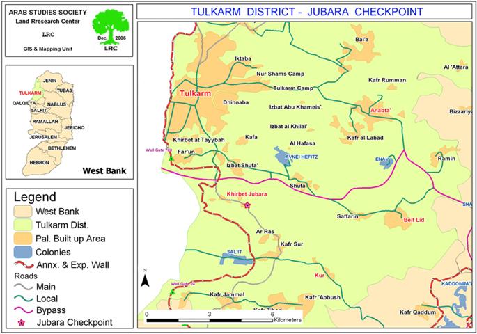
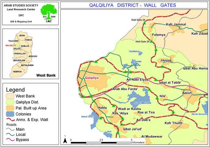
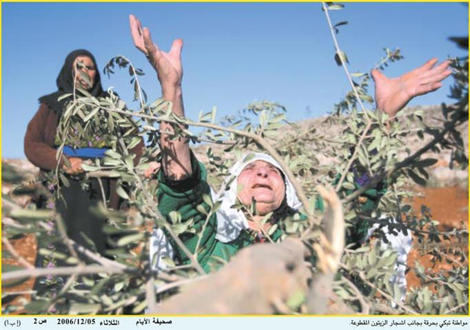
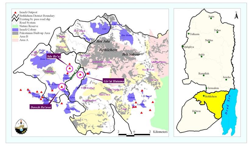
The Israeli Settlers wreaking havoc with the Palestinian Lands and Properties in the Occupied Palestinian Territory
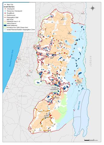
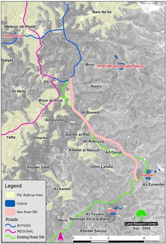
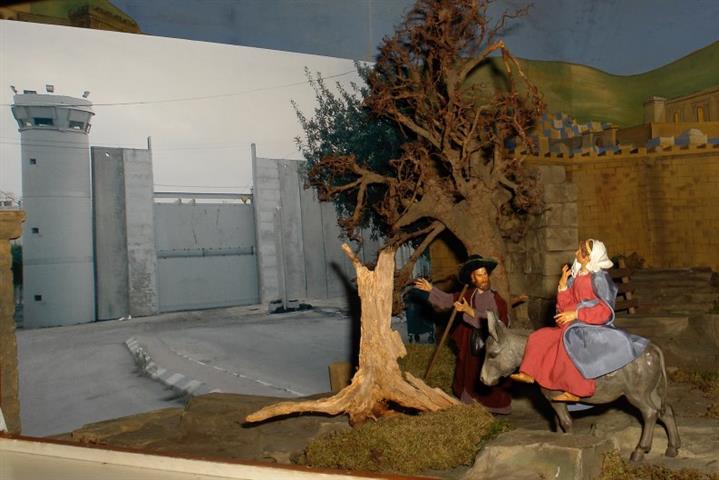
Introduction With the coercive launch of the Israeli settlements program in the occupied Palestinian territory, the Israeli settlers� constitute an immanent and constant threat to the original Palestinian inhabitants of
A new Wall section at the expanse of the lands of Kafr ad Dik and Beir Ballut
The Israeli occupation army issued military order number T/82/06 stating the confiscation of 538 dunums of land of which 350 dunums belong to Kafr ad Dik village and the rest
Jubara and Hawara checkpoints: a barrier not a link
Recently, the Israeli occupation forces began to impose further complications on the Palestinian movement in and out of the city of Tulkarem through the Jubara checkpoint which is supposed to
Ghettoized Palestinian villages suffer further movement restrictions
Qalqiliya Governorate A Daba', Ras at Tira, Wadi ar Rasha, Arab Abu Farda and Arab ar Ramadin are Palestinian residential areas which all are imprisoned in one ghetto inside the
Hagai settlers cut olive trees in Ar Rihiya village
Photo 1: Ar Rihiya-Hebron: a woman laments for her destroyed olive trees. Al Ayyam newspaper Photo 2: Ar Rihiya- Hebron: Settlers' grudge against Palestinian olive trees is reflected in this
معهد الأبحاث التطبيقية – القدس (أريج) يوجه نداء استغاثة لرفض الصيغة الحالية لاقتراح الجمعية العمومية للأمم المتحدة بتسجيل الخسائر الناجمة عن بناء جدار الفاصل العنصري
في شهر تموز من عام 2004، أصدرت محكمة العدل الدولية قرارها الاستشاري حول شرعية بناء الجدار الفاصل في الأراضي الفلسطينية المحتلة، بما فيها القدس الشرقية. كما بين القرار
New Israeli parallel road in Yatta area
The Israeli supreme committee for planning and the sub-committee for roads affiliated to the so-called Israeli 'civil administration in Judea and Samaria' announced a new scheme for the bypass road
The Geopolitical Status in Hebron Governorate
The Governorate of Hebron is located in the southern part of the West Bank. It is the largest Governorate in the West Bank in terms of size and population. Its
El Muro De Segregacion Israeli, aislamiento y de guetización en la Terra Santa
El 30 de abril de 2006 el gobierno israelí aprobó un plan revisado para el muro de la segregación (apartheid) en Cisjordania. El nuevo plan del muro realiza algunos pequeños
Maria und Josef – oder: Keine Chance, nach Bethlehem zu kommen !
In jenen Tagen erließ Kaiser Augustus den Befehl, alle Bewohner des Reiches in Steuerlisten einzutragen. Da ging jeder in seine Stadt, um sich eintragen zu lassen. So zog auch Josef
‘Aboud Village lands’ confiscated and distorted for the construction of the Israeli Segregation Wall
Several Israeli bulldozers started leveling up the lands of 'Aboud village in preparation for the construction of a part-section of the Israeli Segregation Wall, which will portion out the village.
The Geopolitical Status of Jeruslem Governorate
Jerusalem GovernorateJerusalem Governorate lies in the central part of the West Bank; it has an area of 353.679 Km2 and is home to 407,459 Palestinian Jerusalemites (PCBS, 2006). Jerusalem city
The Geopolitical Status in Ramallah Governorate
The Israeli Segregation Plan in the Occupied Palestinian Territory An Overview In June 2002, the Israeli government launched its policy of unilateral segregation between Israel and the Palestinian territory
ARIJ Statement On The 58th Anniversary of The Universal Declaration of Human Rights
As the world commemorate this month the 58th anniversary of the Universal Declaration of Human Rights, the world appear to be as far from the essence of the declaration than