Overview
Wadi Fukin village, 4346 Dunums of land is one of the nine Palestinian villages located in the western part of Bethlehem Governorate. It lies 8 km away from Bethlehem center and approximately 16 km from East Jerusalem, and 0.5 km from the 1949 Armistice Line (the Green Line). The village houses a total population of 1,201 (PCBS 2006) Palestinians.
It is worth mentioning that Wadi Fukin village is one of the many Palestinian villages depopulated and destroyed during the 1948 war and was later rebuilt in the early 1970s when its original residents returned back to their lands to rebuilt their village.
Due to the semi mountainous lands, Wadi Fukin had generous agricultural lands, good grazing areas and open spaces to utilize, which reflect the good productivity of Grapes, fruits, Almond, and olive Oil , that the village famous of.
Decades under Occupation
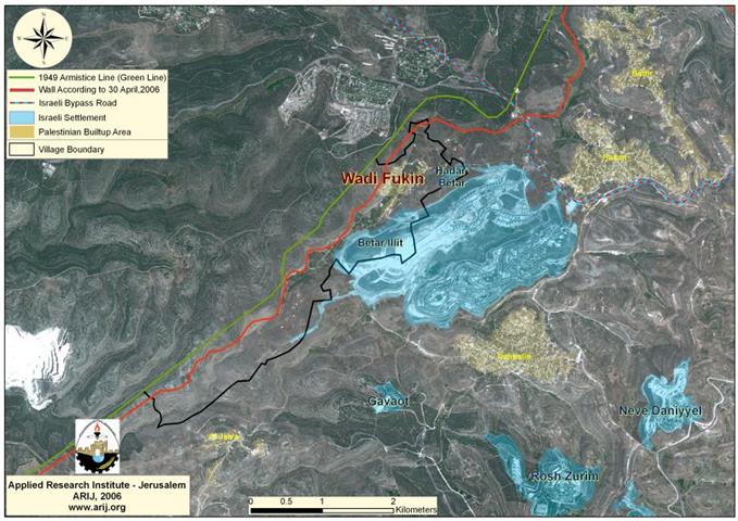
Wadi Fukin village has been targeted by the Israeli occupation from as early as 1948, and when the village was rebuilt following the 1967 aggression on the West Bank, Wadi Fukin lost more of its lands inside the 1949 Armistice Line (Green line) (inside Israel). However, that was not the end for Wadi Fukin, in the year 1978, the Israeli settlement Hadar Betar was established on 53 dunums (ARIJ-GIS Database 2005) of the villages lands, Today, the settlement sets on 57 dunums of lands and houses some 30 Israeli settlers and lies to the northeast of Wadi Fukin, which hindered its residents use of agricultural lands or to expand the villages built-up area. In 1985, the Israeli settlers started establishing the foundation of a new settlement east of Wadi Fukin, on 566 dunums of lands, they called it Betar Illit settlement. Today, the settlement sets on 4712 Dunums (ARIJ-GIS Database 2005) confiscated from Wadi Fukin and the nearby Palestinian village Nahalin. Betar Illit settlement grew faster than any other settlement in the West Bank and about 28000 Israeli settlers inhabit it today. See Map 1

Wadi Fukin village become enclaved by the two Israeli settlements at the villages northeastern and eastern parts (Hadar Betar & Betar Illit) and by the Israeli bypass road #375 from its northeastern part. This bypass road stretches from the northeast of Wadi Fukin, heads towards the northeast and north edges of Betar Ellit and Hadar Betar settlements to finally intersect with bypass road 60 (the main north-south artery of the West Bank). Palestinians traveling on this bypass road are obligated to have a special permit issued from the Israeli civil administration and even though the Israeli Army still allows Palestinians on these bypass roads to this day without permits, thing will not continue so once the Israeli Segregation Wall enclosing the western rural area of Bethlehem is completed. the Israeli Segregation Wall enclosing the western rural area of Bethlehem is completed.
Settlers Violence
The Israeli settlers living in Betar Ellit and Hadar Betar settlements often behave violently with the Palestinians of Wadi Fukin village and the nearby Palestinian villages. Furthermore, at many occasions, the settlers prevent Palestinian farmers from utilizing their lands that are located in the vicinity of both settlements areas, they have gone even further than that to uproot the trees and destroy the field crops by pumping deliberately the wastewater coming out of the settlements into the cultivated land of the village and burn the fields. Such attacks caused enormous economic losses and hazardous health problems to the residents of Wadi Fukin.
The Wall of Disaster
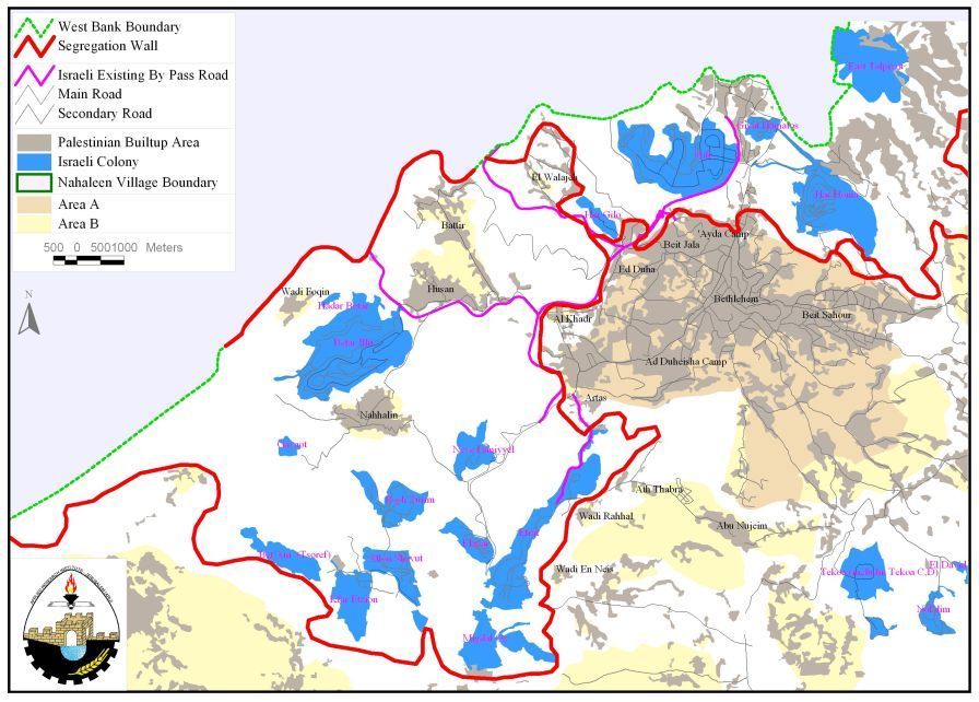
When the Israeli government decided to build the Segregation Wall in the west Bank, Wadi Fukin as a part of Bethlehem western rural area was placed in an enclave, each on its own. However, with several amendments made to the route of the Segregation Wall, Wadi Fukin and the rest of the Palestinian villages at the western rural area (Battir, Husan, Al Jaba, Nahalin, hamlet Afane, Hamlet Beit Zakaria and Hamlet Al Ballutah) were placed in one big enclave, separated and isolated from Bethlehem governorate, which threatens the lives of the Palestinian residents at these villages, the economic status, education, health services, etc.
According to June 2004 Segregation Wall map, the entire western rural villages of Bethlehem was isolated from Bethlehem governorate, Battir and Husan villages were set to be entrapped in one ghetto, Nahalin in another Ghetto, Al Jaba to be included within Hebron governorate, cutting it off from Bethlehem Governorate and as for Wadi Fukin, it was excluded separately in an enclave between the Israeli settlements and the 1949 Armistice Line (Green Line). See Map 2.

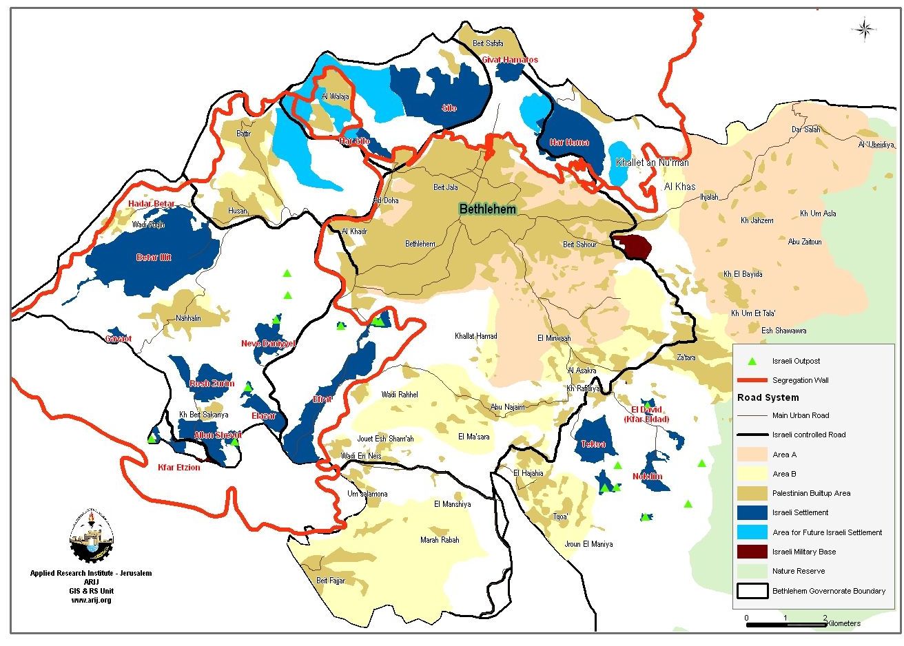
A revised map of the Segregation Wall was issued by the Israeli ministry of defense on February 20, 2005 showed that Wadi Fukin village, along with Husan, Battir, Nahalin, hamlet Afaneh, Hamlet Beit Zakaria and Hamlet Al Ballutah would be included within the Gush Etzion settlement bloc with a single passage way under Israeli control to Bethlehem governorate. See Map 3
According to the new amendments, Al Jaba village is set to be included within the Gush Etzion settlement bloc along with Nahalin, Battier, Hussan and Wadi Fukin, Al Balluta Hamlet, Afana Hamlet and Beit Zakareyya Hamlet in one big enclave. See Map 4
To Conclude
Israels Wall route encloses most of the Bethlehems western villages, and their cultivated lands estimated at 53461 dunums, more than 20000 Palestinian residents of the nine villages (Wadi Fukin, Battir, Husan, Nahalin, Al Walajeh, Hamlet Afana, Hamlet Zakareyya, Hamlet Balluta and Al Jaba) will still lie on the Palestinian side of 1967 boundary, but will have restricted access to Bethlehem as they will be confined in one Big Ghetto along with the 11 settlements comprising the Gush Etzion settlement bloc.
Farmers from Wadi Fukin and the rest of Bethlehem western rural villages will have a hard time, if any at all to market their agriculture products to Bethlehem governorate and any other areas because of the Israeli impose restrictions on their movement. Other than that, these Palestinian villages will no longer be able to control the expansion of the built-up area in their villages, because of Israeli restrictions imposed on building at their villages under the pretext of .
The confiscation and destruction of Palestinian land is clear violation of the Fourth Geneva Convention, Article 147 which clearly prohibits, extensive destruction and appropriation of property, not justified by military necessity and carried out unlawfully and wantonly. Violations of Articles of the Fourth Geneva Convention constitute breaches of the Convention and should be prosecuted as War Crimes.
The Palestinians lost their lands and homes because of the Segregation Wall and before that of the settlements building and expansions, hence threatening the very existences of the Palestinian communities on the long run.
Also Israel continues to violate its obligations as an occupying power under international law rules, and the Israeli practices in the Palestinian territory clearly contradicts with:
-
The International Covenant on Economic, Social and Cultural Rights (ICESCR) – Food (ICESCR, art. 11): The States Parties to the present Covenant recognize the right of everyone to an adequate standard of living for himself and his family, including adequate food, clothing and housing, and to the continuous improvement of living conditions. The States Parties will take appropriate steps to ensure the realization of this right, recognizing to this effect the essential importance of international co-operation based on free consent.
-
The International Covenant on Civil and Political Rights (ICCPR) – Property (ICCPR, article 1) provides that: All peoples have the right of self-determination. By virtue of that right they freely determine their political status and freely pursue their economic, social and cultural development.
Related Cases
-
Betar Ellit Settlement Expansion and the Fate of Wadi Fukin Village (8, February, 2001).
-
Israeli land slays of Wadi Fukin (14, January, 2003).
-
Settlement Expansion and loss of Wadi Fukins land (23, May 2005).
Prepared by
The Applied Research Institute – Jerusalem
ARIJ


