Location and Population
The Palestinian village of Rafat lies 16 kilometers north of Jerusalem city and 5.5 kilometers south of Ramallah city, it has an altitude of 780 meters above sea level. The landscape of the village is a mixture of mountainous and plain fields cultivated with abundance of Old Roman Olive trees. The name 'Rafat' goes back some 3 thousand years ago; it comes from the Canaanite word 'RAPHAEL' which means 'Healed by God' a name that was earned for the many old grave yards that existed in the village that time.
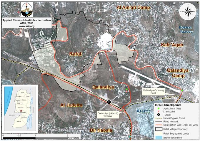
The village's population recorded 219 inhabitants in the year 1922 and continued to increase according to the PNIC (Palestinian National Information Center), reaching up to280 inhabitants in the year 1945. Following the 1948 war, an influx of people forced out of their villages (Daniyal village (east of Ramle), and Beit Thul (west of Jerusalem)), which were destroyed by the Israeli militias, went to live in Rafat, which contributed to the increase of the Palestinian population in the village to 545 by the year 1967. The population recorded additional growth in its population during the years 1987 and 1996 where it reached up to 882 and 914 respectively. Today, the village is a house to 2124 residents (PCBS 2006) and occupies a total area of 3803 dunums (3.803 km�²); out of which, 398 dunums are occupied by the Built-up area (0.398 km�²), 10.5 % of the total village area. The Village is bordered by Qalandyia and Qalandyia airport from the east, 'Ofer Military base from the west, Giv'at Ze'ev settlement from the southwest, Al Jib and Al Judera villages from the south, Ramallah and Al Bireh Cities from the north.
Classification of Lands of Rafat Village!
In the Oslo II Interim Agreement signed in September 1995 between the Palestinian Liberation Organization (PLO) and Israel, the Palestinian occupied territory was categorized into three dominance, which became known as areas A, B and C as a preliminary step to phased withdrawal of the Israeli military forces from the West Bank area until the accomplishment of a final status agreement.
-
Area (A): constitutes the areas where the Israeli army has pulled out fully and Palestinians have complete autonomy over administrative and security issues. Area A, according to the Oslo II agreement, covered the main cities of the West Bank, except for Hebron.
-
Area (B): Palestinians have full control over the civil responsibilities and Israel continues to have overriding responsibility for security.
-
While Area (C): Palestinians have responsibility for civil life such as economics, health and education; however, Israel retains full control over security and administration related to territory where Palestinians aren't allowed to build on the land or even utilize the land for agricultural purposes.
Accordingly, Rafat Village was classified to areas B and C, as indicated in the analysis conducted by the GIS unit at the Applied Research Institute, of which, a total of 433 dunums were classified as Area B (11.4 % of the total village area); while the remaining 3370 dunums, were classified as Area C (88.6% of the village's total area), where all the agricultural lands in the village are located. See Table 1
|
Land Classification |
Area in Dunums |
Percent of Rafat Village area |
|
Area A |
0 |
0% |
|
Area B |
433 |
11.4% |
|
Area C |
3370 |
88.6% |
ARIJ GIS Database – 2006
The village's built up area is scattered between area B and area C where about 151 dunums of the built-up area is located within area B while the remaining 247 dunums lie within area C, which as indicated earlier falls under full Israeli Control and where any kind of construction is prohibited unless it is approved by the Israeli Civil Administration. The procedure of issuing a building permit within area C is an aggravating process with chances of success at almost never. Residents are required to go through a long process to prove their ownership of the land in addition to the overcharged amount of money paid to issue the license.
The village's chance to expand its built-up area in the near future is limited due to scarcity of land available for expansion as most of the lands available for that purpose are controlled by Israel and any construction activity takes place without being licensed will be demolished.
Facilities in Rafat Village
The village of Rafat, as stated by Rafat Village Council, lacks most of the vital facilities, such as medical, educational and public services. The village has only one preparatory school which seat 500 students, including students attendances from nearby villages. In addition, the village lacks minimum medical service facilities, such as specialized clinics (maternity and children's), and emergency, residents of the village have to access hospitals and medical centers located in Ramallah in order to receive proper medical services. The village has Electricity, Water and telephone networks but lacks a Sewage system which is a major problem in the village.
Currently, the village and in cooperation with the KFG (Konferenz Gemeindegrndung) are building a sports club and two playgrounds on lands of the village which will serve the village and the surrounding villages such as Beir Nabala, Al Jib, Al Judera, Beit Hanina al Balad and Qalandyia. The village has also two Mosques, two old grave yards and remains of a church and a convent dated back to the Roman Era.
Rafat and Agriculture
Agricultural revenues constituted the majority of income to some 90% of Rafat's village's population. Today, this percent decreased due to the Israeli implanted and manifested obstacles; the Segregation Wall for one thing, forcing many of them to work in other fields such as services and trade rather than working in Agriculture in order to sustain life. In addition, the location of Rafat village close to Ramallah city (an active center) had a great influence on people who sought jobs in the city besides agriculture.
Furthermore, the Israeli confiscation of Rafat's village lands has also contributed to the decline in number of people who work in agriculture, starting from the establishment of the Israeli Military Base, 'Ofer on lands of the village, the construction of Bypass Road number 45 (see annex 1) and ending with the construction of the Israeli Segregation Wall which is enfolding the village from the east, west and south.
The Israeli Colonization Activities in the Village of Rafat
Following the 1967 war, Israel intensified its colonization activities in the village and was exemplified in the Establishment of 'Ofer military base which costs the village a total loss of 822 dunums. This Military base holds a complex of military courts, a military detention camp, a military detention center, and offices for the Israeli Intelligence where short sessions of interrogation are conducted.
The military base is isolated and encircled with fences all around and several watchtowers. The base is considered as one of the ten largest Israeli Military bases established inside the West Bank, and has always been a source of fear to residents of Rafat and the nearby villages, such as Betunia. To the south of the military base, lies the Israeli settlement bloc of Giv'at Ze'ev (a bloc of 5 Israeli settlements, Givon, Giv'on Hadasha, Giv'at Ze'ev, Har Adar (Givat HaRadar), and Har Shmuel with a total population of approximately 13850 Israeli settlers, all of which sets on an area of 4928 dunums); This bloc helped in a way to reinforce the existence of the military base as a 'protection' tool to it and to the Bypass Road number 45 which bypasses the village of Rafat (extends a length of 1.23 km inside the village boundary) to link the Giv'at Ze'ev settlements bloc with bypass roads network that link all settlements in the West Bank together and with Israel.
Access to Rafat Village
In the past, a time before the construction of Bypass road number 45 and the Israeli Segregation Wall in the village, residents of Rafat were to an extent free to move to the surrounding Palestinian Villages, those located to the east, south and southeast, and to Jerusalem as well, where short secondary roads (about 10 minutes time at maximum) used to connect the village with them and with each other.
The construction of bypass road number 45 in the late nineties has caused the isolation of 220 dunums of Rafat's lands (from the south) including the area of land used for constructing the road itself, causing the remaing area of the isolated land to become inaccessible to villagers due to their location close to the bypass road. The construction of the road has also caused to disruption one secondary road used to connect Rafat with other villages located to the south such as Al Jib, Al Judera, Bir Nabal and An Nabi Samuel and with villages located in the southwest such Beit Duqqu, Beit 'Anan, Beit Ijza, Qatanneh … etc, and instead, villagers of Rafat had to access Qalandyia city first and then head to their destinations.
It was until 2002 that residents of Rafat started to face the real difficulties in reaching their destinations as wall constructions commenced in the village. The wall surrounded the village from three different directions east, west and south and closed off all the secondary roads leading to the nearby Palestinian villages. Villagers of Rafat were limited to only one exit/entrance, from the north, through which, they head to their destinations. Consequently, the route of Rafat residents to their destinations changed and those heading to the nearby Palestinian communities have to go to Ramallah first, to Qalandyia second and then to their destination which cost them more time and money.
Redirecting the movement of Palestinians on Bypass Roads
In July 2005, the Israeli military forces handed out residents of Rafat, Qalandyia, Bir Nabala and Al Judera villages a military order number (52/05/T) which revealed the construction of a 2.5 km long and 60m wide road on 121 dunums of land. An Analysis of the military order by the GIS unit at ARIJ showed that the road is to reconnect the Palestinian villages with each other as to prior the construction of the Segregation Wall.
The Road became operational eight months ago; however, Palestinian residents of Rafat and the nearby Palestinian villages are forbidden from using the Israeli Bypass roads. Such ethnic separation affects the geographical contiguity of the Palestinian villages and at the same time deprives them their right to freedom of movement as such roads were originally built on lands that belong to Palestinians.
The Construction of the Segregation Wall in Rafat Village
Work on constructing the Segregation Wall on lands of Rafat village commenced on the 22ed of August 2002 when the Israeli bulldozers rushed to the village and started razing lands, uproot Olive Trees and level the lands to set the path for the planned Segregation Wall route. According to Rafat Village council, more than 600 Old Roman Olive trees were uprooted from the Village�?�¢??s lands; in addition to hundreds Olive trees from the village were segregated from it owners by the Segregation Wall.
The Segregation Wall around Rafat village is part-section of the Segregation Wall around Jerusalem or what is known as the 'Greater Jerusalem' plan which is going to extend for 133.9 kilometers starting from Har Adar settlement to encompass the Giv'at Ze'ev settlement bloc, part of Modi'in settlement bloc, Ma'ale Adumim settlement bloc and the settlements of East Jerusalem, which include 32 settlements and the Gush Etzion settlements bloc south of Jerusalem. Furthermore, the land area isolated from Rafat village is part of the 151974 dunums of lands isolated by the Segregation Wall within the Israeli 'Greater Jerusalem' plan. Table 1 below details the status of the Segregation Wall around Jerusalem.
|
Status of the Segregation Wall in Jerusalem |
||
|
Status Classification |
Jerusalem Governorate/Km |
Greater Jerusalem/Km |
|
Existing sections |
22.607 Km |
48.58 |
|
Planned sections |
63.331 Km |
110.298 |
|
Under Construction |
47.957 Km |
48.69 |
|
Total length |
133.895 Km |
207.046 |
Source: ARIJ GIS Database 2006
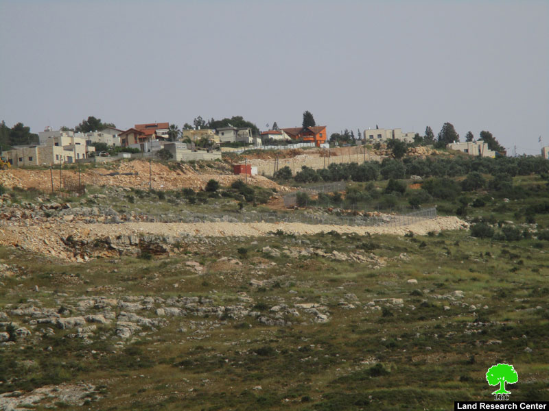
Today, the village of Rafat is surrounded with walls (fences and concrete) from three directions (East, West and south) forming a 'U' letter, where some parts of the wall are very close to the Palestinian Built-up area. See Pictures
The wall extends a length of 5.46 km in the village of Rafat; so far; 80 percent of which is completed in the village where as the remaining 20 percent is undergoing construction to be completed some time prior to the summer of 2007. Table 2 below details the status of the wall in the village.
Table 2: Status of the Wall in Rafat Village
|
Wall Type |
Length in Kilometers |
Percent of total length |
|
Existing |
4.371 |
80 |
|
Under Construction |
1.12 |
21 |
|
Total |
5.461 |
100 |
Source: ARIJ GIS Database 2006
Upon completion, the Segregation Wall stands to isolates 1407 dunums of Rafat village's land behind it. Table 3 below details the Land Use Land Cover of Rafat Village lands and those lands segregated west of the Segregation Wall.
Table 3: Land Use Land Cover of Rafat Village lands and the Lands isolated behind the Wall.
|
Landuse Landcover type |
Land Use Land Cover of the Rafat Village Boundary |
Land Use Land Cover west, east and south of the segregation Wall |
|
Arable land |
1345 |
330 |
|
Industrial, commercial and transport unit |
3 |
0 |
|
Mine, dump and construction sites |
195 |
11 |
|
Open spaces with little or no vegetation |
559 |
315 |
|
Permanent crops |
36 |
30 |
|
Shrub and/or herbaceous vegetation associations |
445 |
48 |
|
Israeli Military Base |
822 |
673 |
|
Palestinian Built-up Area |
398 |
0 |
|
Total Area |
3803 |
1407 |
Source: ARIJ GIS Database 2006

Military Orders in Rafat Village for wall constructions!
On March 22, 2005, the Israeli Occupation Forces handed residents of Rafat village along with Qalandyia, Bir Nabala and Al Judera villages a military order stating the confiscation of 107.5 dunums of their lands for the construction of the Segregation Wall. See Annex 1 (Translation of Military order).
The International Legal Status of the Segregation Wall
In July 2004, the International Court of Justice (ICJ) passed an advisory opinion declaring that the Israeli Segregation Wall to be illegal and in violation of international humanitarian laws. The Court based its decision on international laws, including the Fourth Geneva Convention, the Hague Regulations, and the various human rights treaties
Recalling relevant United Nations resolutions affirming that actions taken by Israel, the occupying Power, to change the status and demographic composition of Occupied East Jerusalem have no legal validity and are null and void, Noting the agreements reached between the Government of Israel and the Palestine Liberation Organization in the context of the Middle East peace process,
The Israeli Segregation Wall violates virtually every existing humanitarian code, human rights and civilized laws; including the right to Self-Determination, the right to freedom of movement, the right to work, the right to medical treatment, the right to education, the right to an adequate standard of living and access to holy places. The ICJ decision upholds the Palestinian s�¢?? right to self-determination, which the Israelis deny them as the Segregation Wall disrupts the territorial integrity, unity and contiguity. 'Self-defense' or 'state of necessity' can not be used as justification for violating this right and other international legal principles and therefore Israel must cease construction and all other states must refrain from supporting Israel in building the Wall.
Moreover, the construction of the Segregation Wall is an explicit violation of all peace agreements signed between the Israelis and Palestinians and a breach to Oslo Interim Agreement which states that: �¢??Neither side shall initiate or take any step that will change the status of the West Bank and the Gaza Strip pending the outcome of the permanent status negotiations�¢?? (Article XXXI, clause 7).
Conclusion
Despite international denunciation, Israel is proceeding with its unilateral plans to build the Segregation Wall; isolating and confiscating large tracts of Palestinian lands; including occupied East Jerusalem. If this continues, the Palestinian communities in Jerusalem Governorate will be completely surrounded by a complex of Walls, settlements and bypass roads that will eliminate any future possibility for the Palestinian community to expand and thus jeopardize sustainable development of these areas on the long run.
Annex 1
|
Israel Defense Forces Order to Seize lands n0 52/05/T
According to my authorities as a Military Chief Commander in the Region of Judea and Samaria, and as I believe that it is imperative for military reasons due to the special security situation in the region, I order the following:
1- In This Order:
The 'Map' – signed in scale 1: 10000 and attached to the order is an essential part of this order.
The 'Lands' – An area of land which is 107.5 dunums, marked in red in the map and located in the following villages:
Qalandyia
Rafat
Al Judera
Al Judera
2- I announce by that the above mentioned lands are seized for imperative military purposes.
3- The IDF seize the lands and an absolute control of the land is given to the Military Chief Commander of the Central Region through the Ministry of Defense Chief Officer in the Civil Administration Office.
4A-1 This military order is to be notified to Land Owners or those who act on behalf of them by posting it at the District Coordination Office in Jerusalem and dispersing it on the lands by any possible mean.
4A-2: A notification to a field Visit to the site is to be sent by the Office of the District Coordination Office in Jerusalem to identify the lands.
4-B Copies of the military order and the attached map are available for interested parties at the following places:
4C- Copy of the military order and the attached map is set at the Jerusalem District Coordination Office Board for 10 days from the issuance date of the military order, as mentioned in Part (4A).
4- Copies of this military order and the attached map are handed out to Land owners or to the District Co-ordination Office in Bethlehem.
6- Land owners or those who act on behalf of ownership have the right to object the military order in 7 days from the date of the field visit as mentioned in Part (4A) above through the District Coordination Office in Jerusalem or at the Office of the juridical advisor in the region.
7- This order is valid from the date it was signed and until 31/12/2007.
8- This order is called: 'Order to seize lands n0 52/05/T (Judea & Samaria) 5765-2005.
Ya'er Naveh |
Annex 2: Bypass Road 45
Extends from Qalandyia crossing (previously mentioned as Qalandyia checkpoint), to link the industrial zone of 'Atarot with the bloc of Giv'at Ze'ev, southwest of Rafat Village, and bypassing its lands and cutting some of its lands.
Prepared by
The Applied Research Institute – Jerusalem
ARIJ