-
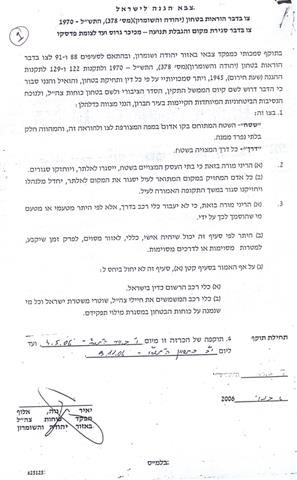
As a continuation of the Judaization process of the old city of Hebron, the Israeli occupation army recently issued a set of military orders stating shop closure and restricting Palestinian pedestrian and vehicular movement inside the old city. The set which carries the number of 378 is comprised of 21 attachments covering all the roads and neighborhoods used by or lived by Jewish extremist settlers. Click here to download the military orders

photo 1 & 2: copies of the 21 military orders)
The following is detailed information about these orders:
Table 1
List of Military Orders Regarding Shop Closure and Movement
Restrictions in H2 Section of the City of Hebron.
|
No. |
Purpose |
Location |
|
1
|
Closure of commercial shops and the prevention of Palestinian vehicular movement. |
Al Shohada street between Al Sahle and the entrance to the settlement of Beit Hadassah |
|
2 |
Declaring the vicinity of Abraham Avino settlement as a 'Closed Area' to which no Palestinians are allowed to enter to. |
The settlement, the Old Vegetable market and a stretch of Al Sahle street. |
|
3 |
Declaring the vicinity of the Givat Ha'avot settlement as a 'Closed Area' to which no Palestinians are allowed to enter. |
The whole settlement including the police station. |
|
4 |
The prevention of Palestinian vehicular movement in the Pharmacy Street. |
The stretch of Al Shohada Street between Al Sahle junction and the Pharmacy checkpoint. |
|
5 |
The prevention of Palestinian vehicular movement in the perimeter of the Jewish Cemetery |
Starting from Jabal Al Rahma Mosque, surrounding the Jewish Cemetery until it completes the circle at the first checkpoint of Tel Rumeida. |
|
6 |
Declaring the vicinity of Tel Rumeida settlement as a 'Closed Area' to which no Palestinians are allowed to enter to. |
The area between the Tel Rumeida 2nd checkpoint and the entrance of Abu Haykal house. |
|
7 |
Closure of commercial shops and the prevention of Palestinian vehicular movement on Tel Rumeida street |
The road connecting between the Shohada street checkpoint (close to Bab Al Zawiye) and the Tel Rumeida 2nd checkpoint. |
|
8 |
The prevention of Palestinian vehicular movement between Tzion street (north section) and the entrance to the Givat Ha'avot. |
The road connecting between the entrance of Givat Ha'avot and about half the length of Kiryat Arba' main road (the upper section of the street). |
|
9 |
The prevention of Palestinian vehicular movement in the Tzion street (southern section) |
The second section of the Kiryat Arba' main road leading to the Prayers Road junction. |
|
10 |
Closure of commercial shops and the prevention of Palestinian vehicular movement on the road between the Banks Junction and Shohada CP. |
All shops along Al Shohada street between the Shohada checkpoint until the Beit Romano CP. |
|
11 |
The prevention of Palestinian vehicular movement in the Prayers Road (eastern section) |
The segment of the road connecting between the vicinity of the military tower in Wadi Al Nasara (aka Wadi Al Hussain) and the Prayers Road junction. |
|
12 |
The prevention of Palestinian vehicular movement in the Old Al Shallalah street (western section) |
The section of Old Al Shallalah street located between the H2 boundary and back of Beit Hadassah settlement. |
|
13 |
The prevention of Palestinian vehicular movement in the Prayers Road |
The total length of the security road connecting between the Prayers Road and the Ibrahimi Mosque. |
|
14 |
Closure of commercial shops and the prevention of Palestinian vehicular movement on the Old Al Shallalah street beneath the settlement of Beit Hadassah |
Shops beneath the settlement that are located on the Old Al Shallalah street. |
|
15 |
The prevention of Palestinian vehicular movement in the road connecting between Tzion Street and Road 160. |
The Prayers Road between its junction and the Ibrahimi Mosque. |
|
16 |
The prevention of Palestinian vehicular movement in the Old Al Shallalah street (eastern section). |
The section of the Old Al Shallalah street connecting between the back of the settlement of Beit Hadassah until the Beit Romano checkpoint. |
|
17 |
The prevention of Palestinian vehicular movement in the road connecting between the Ibrahimi Mosque and Tzion Street |
The road connecting between the Jewish entry point to the Mosque and the close-by Prayers Road checkpoint. |
|
18 |
The prevention of Palestinian vehicular movement in the shops area in front of the Ibrahimi Mosque. |
The area between the Jewish entry point to the Mosque and the checkpoint at the Muslim entry point. |
|
19 |
Declaring the vicinity of the Beit Romano as a 'Closed Area' to which no Palestinians are allowed to enter. |
The area located between checkpoint and Al Shohada street, including the military camp. |
|
20 |
Declaring the Ibrahimi Mosque Compound as a 'Closed Area' to which no Palestinians are allowed to enter (??) |
The Ibrahimi Mosque compound. |
|
21 |
Closure of commercial shops and the prevention of Palestinian vehicular movement between Al Sahle street and the Ibrahimi Mosque checkpoint. |
The road connecting between Al Sahle street and the Ibrahimi Mosque checkpoint. |
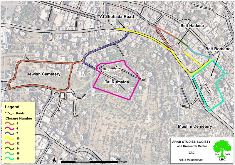
Map 1: map of the military orders number 5,6,7, 10,12,14, 16,19

Map 2: map of the military orders number 1,3,4,15,17,18,20,21
(map 3: map of the military orders number 2,8,9,11,13)
Introduction to Hebron
In January, 1997, the Hebron protocol was signed by Israeli and Palestinian Authority according to which the city was divided into Hebron 1 and 2. Hebron 2 covers approximately 20 % of the municipal territory. It comprises the entire Old Suq and areas adjacent to the Israeli colonies. The Protocol authorizes security and civil administration to the Israeli occupation in Hebron 2, while in Hebron 1 the Palestinian authority was given full security and civil administration. In 2002, the whole city was re-occupied by the Israeli army.
Once the centre of Hebron's commercial and cultural life, the old Suq is now virtually deserted. The city of Hebron is the second city after Jerusalem with Jewish colonies inside its urban area where there are about 600 colonists who live in the four colonies of Avraham Avino ( Old Market), Beit Rumano ( Usama Ben Al Mungiz School), Beit Hadassah ( Daboiya) and Ramat Yasha ( Tel Rumaida ). The Israeli colonists in Hebron are protected by more than 1500 Israeli soldiers and security men. On the other hand, there are two larger colonies whose population exceeds 7000 sit on the hills overlooking the Hebron's eastern quarters- Kiriayt Arab' , Givat Kharsina and Giv'at Ha'avot ( See the attached map 3).
Hebron is the second largest city in the West Bank after Nablus with a population of 170 000 of which about 35000 live in Hebron 2 which is under total Israeli control.
Movement restriction in Hebron 2
The city of Hebron 2 is surrounded with checkpoints, road blocks and military barriers cutting roads leading to other parts of the city in Hebron 1 and even to other parts of Hebron 2. Farmers from around the city has no access to the city's old markets, including the vegetable market, gold market, yogurt market, leather market and others which have been under closure since the beginning of the current Intifada.
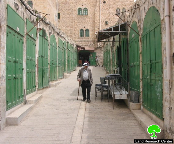
(photo 2: a closed commercial road in Al Qasaba /( old Suq) quarter of Hebron)
As of September, 2006, more than 82 closures of different kinds block Hebron 2 area, particularly the old city and Suq. Many of these block the exits from the Old Suq toward Al Shohada street or onto ' prayers road ' which was built for exclusive Jewish use from Kiriayt Arba' to Ibrahimi mosque ( for related information, see case study entitled ' Israeli ' Prayers' Road ' is being built on the ruins of ancient Palestinian houses – Old city of Hebron' Sep, 2005 ).
Restrictions on movement were imposed on Palestinians on all roads that run between, toward and adjacent to colonies. Out of the aforementioned closures, there are 14 checkpoints preventing Palestinians from driving or walking inside Hebron 2. Those who live beyond are required to be registered with the Israeli army to reach their homes.
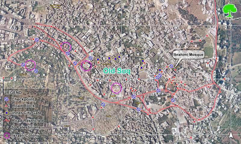
(photo3: Closures and movement restrictions in Hebron's old city)
Prepared by
The Land Research Center
LRC