Beit Ijza is a Palestinian village located 10 km northwest of occupied East Jerusalem. The village has an area of 2526 dunums and houses a total population of 671 inhabitants (PCBS, 2006). The village is surrounded by Beit Duqqo from the northwest, Beit Annan from the west, Al Qubeibeh from the southwest, Biddu from the south and the Giv’at Zeev settlement bloc from the east.
Most of Beit Ijza’s residents depend mainly on cultivation as their main source of income. The village is rich with Vine, Almond and Olive trees where more than 40% of Beit Ijza's lands are used for cultivation. The village has one elementary school and one secondary school for females, in addition to two Kindergartens. The village lacks proper medical facilities with adequate service care, which is why the residents of Beit Ijza depends on fast access to proper medical centers in the town of Ramallah or Jerusalem.
The Israeli settlements east of Beit Ijza
Beit Ijza village is bounded from the east by the illegal Israeli settlements of Givat Hadasha and Giv'at Hadasha “B” which are part of the Giv’at Zeev settlements bloc. The bloc’s settlements are all constructed on lands confiscated from Beit Ijza and the nearby villages of Biddu, Al Jib, Beit Duqqu and Beit Surik. Table one below shows the Israeli settlements of the Giv’at Zeev settlements bloc bounding Beit Ijza village.
Table 1: The Israeli settlements that surround Beit Ijza village
|
Settlement |
Area/ Dunums |
Date of Establishment |
No. of Settlers |
|
Givat Hadasha |
313 |
1980 |
1179 |
|
Givat Hadasha B |
64 |
1991 |
NA |
|
Givon |
118 |
1978 |
1179 |
|
Givat Zeev |
2,856 |
1982 |
10635 |
|
Total |
3,351 |
|
12993 |
Source: ARIJ Data base- GIS
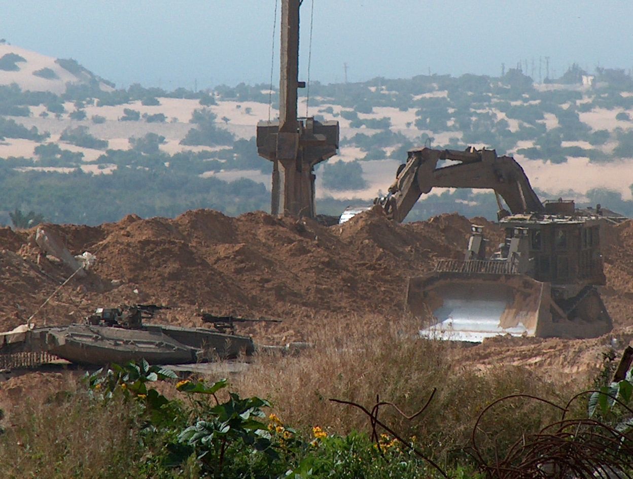
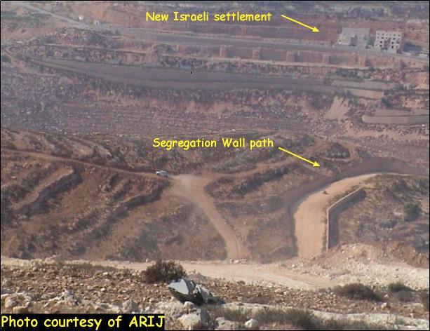
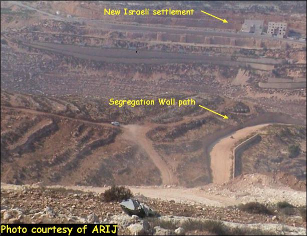
In close proximity to the settlements bloc of Giv'at Zeev, the Israeli Government is preparing to construct a new neighborhood with several hundreds housing units to expand the settlement bloc on the expanse of the Palestinian agricultural lands. See photo 1 & Photo 2

The Segregation Wall in Beit Ijza village
In 2003, the Israeli Army handed the residents of Beit Ijza a series of military orders to confiscate hundreds of dunums of agricultural lands mostly planted with Olive trees designated for the construction of the Segregation Wall on lands owned by Palestinians.
On March 10, 2003, the Israeli Army handed the village council of Beit Ijza military order # (T/95/04) informing them the confiscation of 144.2 dunums of agricultural lands located within Block 2, under the pretext of military necessities. As a result of the military order, 793 dunums of Beit Ijza lands were isolated behind the Segregation Wall due to the military, and hundreds of Olive trees and other fruitful trees were uprooted to build the Wall.
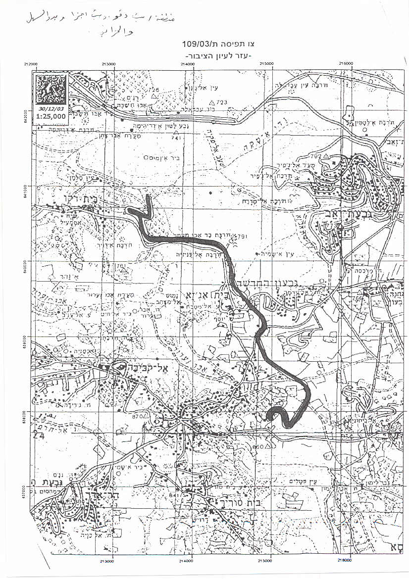
Moreover, On December 30, 2003, the Israeli Army handed the councils of nearby villages of Beit Duqqu, Beit Iksa and Biduu military order # (T/109/03) to confiscate 334 dunums of their agricultural lands across a length of 5502 meters and a width of 80 meters. ) to confiscate 334 dunums of their agricultural lands across a length of 5502 meters and a width of 80 meters.
On June 29, 2004, the Israeli High Court ordered a halt to the construction of a 30 Kilometer section of the Segregation Wall affecting nine Palestinian villages. The villages, Beit Surik, Biddu, Qattana, Al Qubeibeh, Beit 'Anan, Beit Leqia, Beit Duqqu, Beit Ijza, Nabi Samuel and Beit Iksa. The court's order came as a result of an appeal presented by Palestinian residents of the nine communities. The residents filed suit in an attempt to preserve their rights under international law and to challenge the Wall's location which isolated them from neighboring Palestinian areas in the West Bank.
Israel's High Court specified that certain changes should be made in the wall's route in order to address humanitarian concerns and the rights of the affected communities. The court ruled that:
1. The Segregation Wall is legal under domestic Israeli law but the path along north and northwest Jerusalem should be changed to address humanitarian concerns.
2. Israeli military planners designing the route of the Wall must attempt to minimize the humanitarian impact on Palestinian civilians living in the nine villages and plan the route of the Wall according to 'the proper balance between security and humanitarian considerations….'
The Israeli High Court declined to rule on the entire Segregation Wall project, but restricted its ruling to the 30 kilometers section affecting the nine villages. The Court also failed to suggest a new route for the Wall or set a timeline for the changes to take place. The court also neglected the relevant articles of international law which suggest that the Wall's route be redrawn along the Green Line; the Armistice line between Israel and the Occupied Palestinian Territory (OPT).
Later on, on March 21, 2005, the Israeli Army came up with a new military order holding number (T/51/05) to confiscate 91 dunums from the two villages of Beit Ijza and Beit Duqqu as an alternative route option for the Segregation Wall. See Map of the Segregation Wall in Beit Ijza Village

Nearly 22% of Beit Ijza’s lands will be isolated behind the Segregation Wall
According to the Segregation Wall Plan, 22% (566 dunums) of Beit Ijza’s lands will be isolated and become inaccessible to its owners. 10% of the Arable land of the village that are cultivated with permanent crops will be isolated (mainly consist of Olive trees) and will increase the burdens of life for the villagers’ economic wellbeing as they depend on agriculture for their main source of income, especially on Olive trees. The table below shows the land classification inside the village boundary and the land that will be isolated behind the Wall.
|
Land classification Land Use Land Cover (LULC)
|
Total Area in the village boundary/ Dunum |
Total Area inside the Wall/ Dunum |
Percentage of lands isolated (%) |
|
Arable land |
960 |
98 |
10% |
|
Israeli settlement |
207 |
207 |
100% |
|
Palestinian Built-up Area |
153 |
0 |
0 |
|
Permanent Crops |
65 |
0 |
0 |
|
Shrub and/ or herbaceous |
1141 |
261 |
23% |
|
Total |
2526 |
566 |
22% |
Source: ARIJ Data base- GIS 2006

Conclusion:
The Wall cuts deep into the Palestinian territory in the West Bank, isolating thousands of Palestinians, creating ghettos completely surrounded by Walls and trenches, appropriating large areas of Palestinian land and destroying hopes for peace. The Israeli government continued to follow a policy that aimed at seizing more Palestinian lands and violating its obligations under the Fourth Geneva Convention and UN Security Council resolutions including resolution 465 (1979) related to settlements in the Arab territories occupied since 1967, including Jerusalem. The resolution determines that 'all measures taken by Israel to change the physical character, demographic composition, institutional structure or status of the Palestinian and other Arab territories occupied since 1967, including Jerusalem, or any part there of, have no legal validity. Therefore, Israel's policy and practices of settling parts of its population and new immigrants in those territories constitute a flagrant violation of the Fourth Geneva Convention relative to the Protection of Civilian Persons in Time of War, and also constitute a serious obstruction to achieve a comprehensive, just and lasting peace in the Middle East'.
Prepared by
The Applied Research Institute – Jerusalem
ARIJ