On the 5th of September 2006, the Israeli Army handed out residents from Bethlehem and Hebron Governorates new military order informing them that parts of their lands will be confiscated to construct a new terminal south of Bethlehem Governorate and also to resume the construction of the segregation wall in that area.
The new military order holds number (69/06/T) and confiscates 152 dunums of lands of Al Khader and Beit Fajjar in Bethlehem and Beit Ummar in Hebron. Lands stated for confiscation lie within the following Parcels
-
Beit Ummar (parcel 2: Abu Soda mountain )
-
Beit Fajar (parcel 5: Wadi Al Bateekh and Thaher Um Salmona) and
-
Al khader (Wadi An Nis). see copy of military order and Translation in English
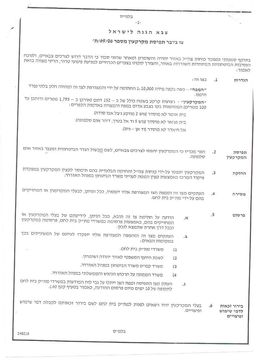
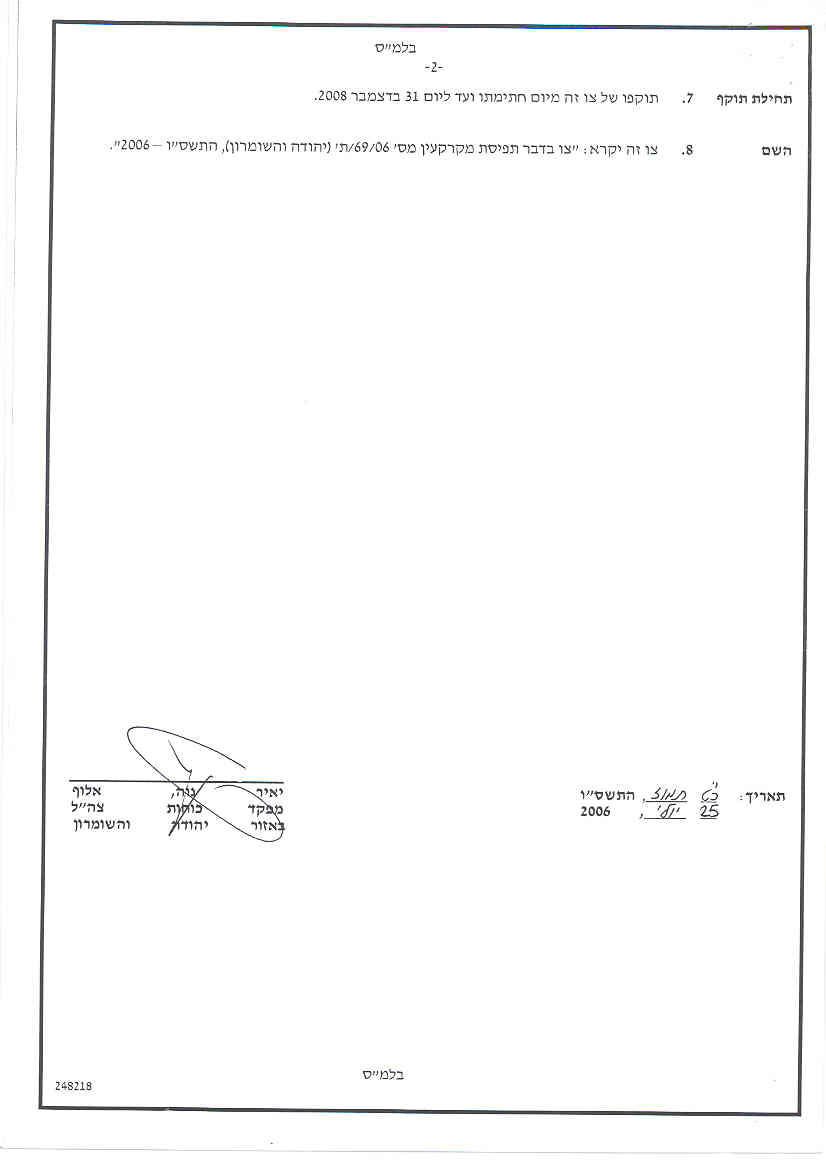
Translation of military order number (69/05/T)
|
Israel Defense Forces Order to Seize lands n0 69/05/T
According to my authorities as a Military Chief Commander in the Region of Judea and Samaria, and as I believe that it is imperative for military reasons due to the special security situation in the region, I order the following:
1- In This Order:
The 'Map' – signed in scale 1: 10000 and attached to the order is an essential part of this order.
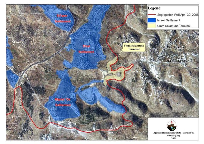
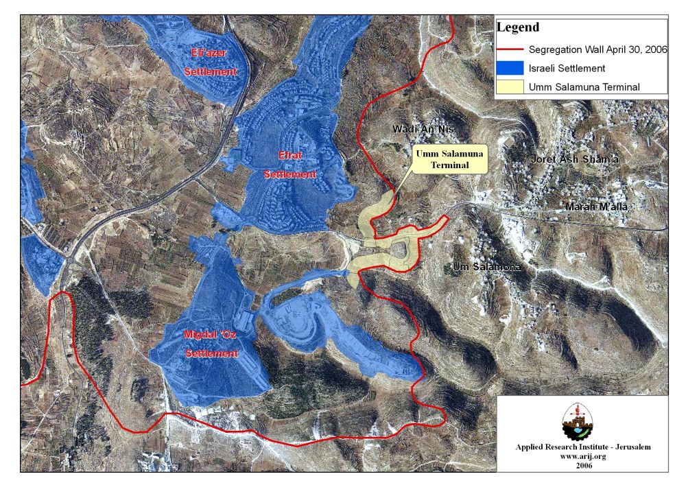
The 'Lands' – An area of land which is 152 dunums (1,795 meters long and 100 meters wide), marked in red in the map and is located in lands of the villages :
2- I announce by that the above mentioned lands are seized for imperative military purposes, to construct the Wall and a terminal in Um Salamona area.
3- The IDF seize the lands and an absolute control of the land is given to the Military Chief Commander of the Central Region through the Ministry of Defense Chief Officer in the Civil Administration Office.
4- Copies of this military order and the attached map are handed out to Land owners or to the District Co-ordination Office in Bethlehem.
5A- This military order is to be notified to Land Owners or those who act on behalf of them by posting it at the District Coordination Office in Bethlehem and dispersing it on the lands by any possible mean.
5B- Copies of the military order and the attached map are available for interested parties at the following places:
5C- Copy of the military order and the attached map is set at Bethlehem District Coordination Office Board for 10 days from the issuance date of the military order, as mentioned in Part (5A).
6- Land owners or those who act on behalf of ownership have the right to object the military order in 7 days from the date of the field visit as mentioned in Part (5A) above through the District Coordination Office in Bethlehem or at the Office of the juridical advisor in the region.
7- Land Owners have the right to go to the District Coordination Office in Bethlehem to get usage expenses and compensation.
8- This order is valid from the date it was signed and until 31/12/2008.
9- This order is called: 'Order to seize lands n0 69/06/T (Judea & Samaria) 5765-2005.
Ya'er Naveh
|
Five Other Terminals in Bethlehem Governorate
Um Salamuna terminal is the sixth terminal identified by the Israeli Army in Bethlehem Governorate. During the last couple of years (2004 -2006), the Israeli Occupation Forces declared the construction of five other terminals in Bethlehem Governorate; all of which aim to tighten the Israeli grip around Palestinian population centers, separate Palestinian owners from their isolated lands behind the Segregation Wall and most significantly to validate the separation from isolated Jerusalem. The previously declared terminals around Bethlehem governorate are; Rachel's terminal at the north entrance of Bethlehem city, Al Walajeh terminal northwest of Bethlehem, Al Jab'a Terminal southwest of Bethlehem, Al Khader Terminal west of Bethlehem and Mazmuria Trade Passage east of Bethlehem. Below is a brief description for each of the terminals with their status.
1- Rachel's Terminal (Gilo 300): A Border Passage at Bethlehem Northern Entrance- Status: Operational
Constructions at Rachel's Terminal started early in the year 2004. A number of caravans were added to the site in addition to well developed equipments, watch towers and security establishments, aiming at transforming the site into a huge terminal (crossing border) and totally separating Bethlehem from Jerusalem. On November 15, 2005, the Israeli authorities inaugurated terminal Gilo '300' in the northern entrance of Bethlehem Governorate. See previously published case study
2- Mazmuria Terminal – A Trade Passage at Bethlehem Eastern Entrance- Status: under construction
In September 2005, the Israeli Army declared some land area in Al Khas and An Nu'man Villages located east of Bethlehem confiscated. The confiscation process was carried out when four Israeli military orders holding numbers (156-5-T), (154-5-T), (155-5-T) and (52-05); were handed out to residents of the two villages informing them that 43 Dunums of their lands will be confiscated to construct a trade passage and to an additional part sections of roads designated to serve the trade passage, which will lead toward Har Homa settlement and consequently to Israel. Furthermore, the Israeli Army plans to established a military camp on 127 Dunums of land all belong to Palestinians from Beit Sahour city once the construction of the Segregation Wall is completed. See previously published case study
3- Al Khader Passage- Status: under construction
On November 21, 2005, the Israeli Army issued military order # 210/05/T to confiscate 85 Dunums (according to the order) from three Palestinian communities west of Bethlehem district, Beit Jala, battir and Al-Khader to construct a tunnel and a terminal for travelers between Bethlehem western rural area and Bethlehem governorate. The confiscated lands are located within Block (2) of Al Khader village lands and Blocks 12 and 13 of Battir village lands and Block 2 of Beit Jala city lands. The new Israeli military order constitutes a border point between Bethlehem western rural villages (Battir, Husan, Nahalin and Wadi Fukin, in addition to the three hamlets Afaneh, Al Balluta and Khallet Beit Sakaryia) – population exceeds 18000), which will be entrapped by the Segregation Wall and the rest of Bethlehem district.
The location of the tunnel is under the Israeli controlled bypass road # 60, whereas the area targeted by the military order extends along Al Khader village trail of bypass road # 60. The tunnel goes underneath bypass road # 60 to route Palestinian residents of western rural villages to bethlehem’s services center. However, Palestinian going in either direction in the tunnel will have to go through the terminal under the Israeli forces supervision,as for those who own lands beyond the Segregation Wall and must undergo the tunnel and cross the terminal, they are required to submit a proof of land ownership in order to pass through. Click here for related cases
4- Al Walajeh Terminal (Har Gilo Terminal)- Status: in planning phase
On February 19, 2006, the Israeli Occupation Forces issued a new military order number (25/06/T) to confiscate 39.8 dunums of lands from Al Walajeh Village and Beit Jala city, block 3 and block 2 respectively for military purposes, mainly for the construction of a new Terminal in the area, 'Har Gilo Terminal' which will tighten the access of Al Walajeh residents into and out of the village. The military order is a complementary to the Israeli Segregation Wall plan which is being implemented on lands of the village. See section of Al Walajeh Village. Read Previously published Case Study
5- Al Jab'a Terminal- Status: Planing phase
On August 22, 2005, the Israeli Occupation forces handed out residents of Al Jab'a two military orders declaring the confiscation of 181 dunums for the construction of Al Jab'a Terminal. According to the first military order, which hold number (T/158/05), a total of 110 dunums of Al Jab'a lands and the nearby village of Surif were designated for confiscation to alter the existing checkpoint south of Al Jab’a to a trade passage. The terminal to be will snatch 43 Dunums from Al Jab'a village, 64 dunums from Surif, where as the remaining 3 Dunums comes from lands located inside the 1949 Armistice Line (Green Line), but originally belong to Al Jab’a village. Read previously published Case Studies
The Israeli Segregation Wall in Bethlehem Governorate
The Segregation Wall in Bethlehem Governorate will stretch a length of 52.2 kilometers across Bethlehem borderlands; isolating in the process some 73 km² (73000 dunums) of land, which makes 12% of the Governorate’s area (608 km²). So far, considerable parts of the Segregation Wall are completed, where as the work on the final stages along the western terrains of the Governorate are either under-construction or in planning phase.
The Segregation Wall engulfing the Western Rural Area
The western rural villages are a cluster of palestinian coimmunitties locvated west of Bethlehem governorate. This Palestinian community cluster was systematically compromised since the Israeli Army captured the West Bank in 1967 and started the colonization process there. Today, with dozens of settlements built there and Israel has decided to realize an old/ new plan to include this settlements cluster (Betar Illit, Hadar Betar, Rosh Tzurim, Eliazer, Efrat , Neve Daniel, Migdal 'Oz , Allon Shevut, Tsoref (Beit 'Ain) , Kfar Etzion and Gava'ot), which is identified as the Gush Etzion bloc inside the Segregation wall. The Segregation Wall extend from the northwestern parts of Beit Jala (from bypass road 60, the tunnel section) and runs southward along bypass road 60 to Artas village where it directs towards the southeast to encompasses all of Efrat settlement. Construction work of this 16.3 Km (31% of the total wall length in Bethlehem Governorate) stretch Segregation Wall is underway as of December 2005 and is expected to be completed by the end of 2006. . This wall section will also confine the western rural villages of Al Walajeh, Battir, Husan, Nahalin, Al Jab'a, Wad-Fukin, Khallet 'Afaneh, Khallet Al Balluta and Khallet Beit Sakaria in one Big Ghetto; (area 53,461Dunums) will be segregated West of the Wall from Bethlehem Governorate..
Um Salamuna Terminal- Status: planning phase
The plan for Um Salamuna terminal comes to serve Israeli policy to tighten Palestinian movement and access to their agricultural lands, but more than that, it will serve as a commercial terminal leading to alternative route for trucks to use in order to avoid using the settlers bypass road 60.
The Israeli violations in International Law
The Israeli policies adopted in the occupied Palestinian territory violate Palestinian human rights under international law and the fourth Geneva Convention of 1949 systematically, which constitute a crime of apartheid according to the International Convention on the Suppression and Punishment of the Crime of Apartheid (1973) which defines apartheid as: 'the imposition of various legislative measures on different racial groups while injuring the rights of one. Moreover, the crime of Apartheid comprises a 'crime against humanity' and 'a serious threat to international peace and security'.
Prepared by
The Applied Research Institute – Jerusalem
ARIJ