• About The Project
  • Palestine in Century
  • Selected Maps
  • Glossary
  • About ARIJ
  • About LRC
  • By Year
    • Case Studies By Year
    • Daily Report By Year
Friday, May 9, 2025
POICA
No Result
View All Result
  • Home
  • Settlements
    • New Israeli Settlements
    • Settlement Expansion
  • Israeli Violations
    • Agriculture
    • Confiscation
    • Demolition
    • Environment
    • Eviction of Palestinians
    • Settlers Attacks
  • Bypass Roads
  • Israeli Plans
  • Segregation
    • Checkpoints
    • Closure
    • Separation Plans
  • Military Orders
  • Reports
    • Daily Report
    • Monthly Report
    • Quarterly Report
No Result
View All Result
POICA
No Result
View All Result

Resumption of Wall construction in the biggest finger-like corridor in the West Bank

August 15, 2006
in Separation Plans
Resumption of Wall construction in the biggest finger-like corridor in the West Bank

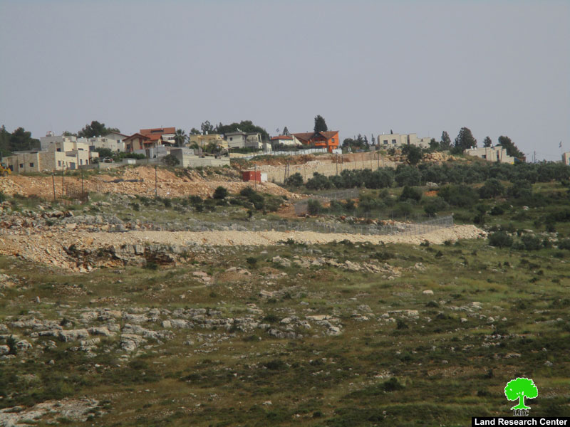
(Photo 1: the yellow section of the Wall currently under construction)


The Israeli army bulldozers resumed works in the construction of the Annexation and Expansion Wall in the lands of the village of Kafr Laqif, Hajja, Deir Istiya and Azzun in Qalqiliya and Salfit governorates. This action came after the Israeli Supreme Court had rejected the appeal presented by the owners of the target land in these four villages.


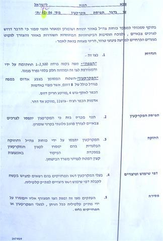
Last January, the commander of the Israeli army in the West Bank, Ya'ir Neve, issued military order number T/15/06 stating the confiscation of 279 dunums from the above four villages for the purpose of constructing a new stage of the Annexation and Expansion Wall. 


According to the order, more than 279 dunums of lands are targeted for confiscation as followed: Hajja, Qalqiliya (basin # 11 and 9); kafr Laqif, Qalqiliya (basin # 4 and 1); Deir Istiya, Salfit (basin # 18) and Azzun, Qalqiliya (basin # 2). The planned route in this section is about 2.800 meters long by 100 meters wide. It includes 'special security arrangement' as stated by the Israeli army's revised Wall map of April, 30th, 2006. The 279 dunums refer only the area that will be devastated under the path of the Wall. Apart from this, hundreds of dunums will be separated behind the Wall when it has been completed.   


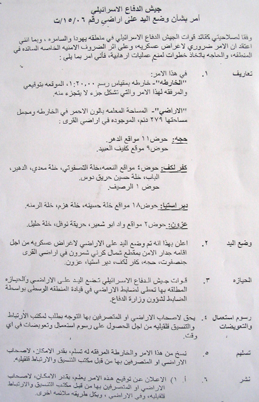
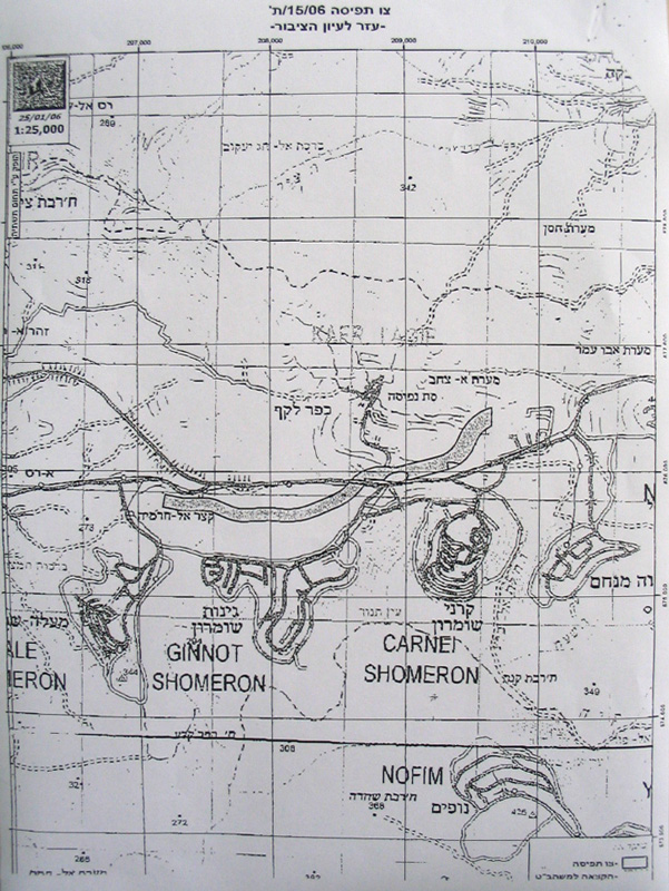
(Photos 1 & 2: copies of the military order and the attached map)


Location, population and area

The following table provides information on the four Palestinian villages by Location, population and area:


No

Village name

Location

Population

Area in dunum


Total

Built up

1

Hajja

Qalqiliya

2000

11717

932

2

Kafr Laqif

Qalqiliya

750

2579

298

3

Azzun

Qalqiliya

6500

9140

1525

4

Deir Istia

Salfit

3500

34000

900

Source- the GIS unit at LRC.


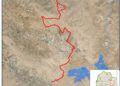
Closure of Kaf Laqif main entrance

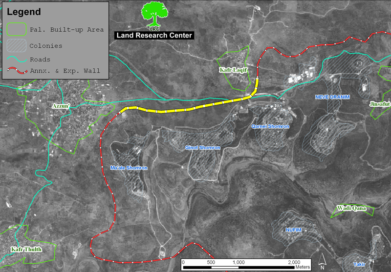
Sources at kafr Laqif village council confirmed to LRC field worker that  if the Israeli army goes on with its plans to build the Wall it will lead to total closure of the village's only entrance to the main Nablus-Qalqiliya road as the village is located at the northern side of this road ( see the attached map). In addition, hundreds of dunums will be separated behind the Wall apart from those to be destroyed under its path.


(Map 1)


The sources added that the affected Palestinian village councils and municipalities have presented another appeal to the Israeli high court against the recent actions, stressing that the local people will spare no effort to defend their land.


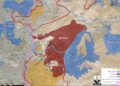
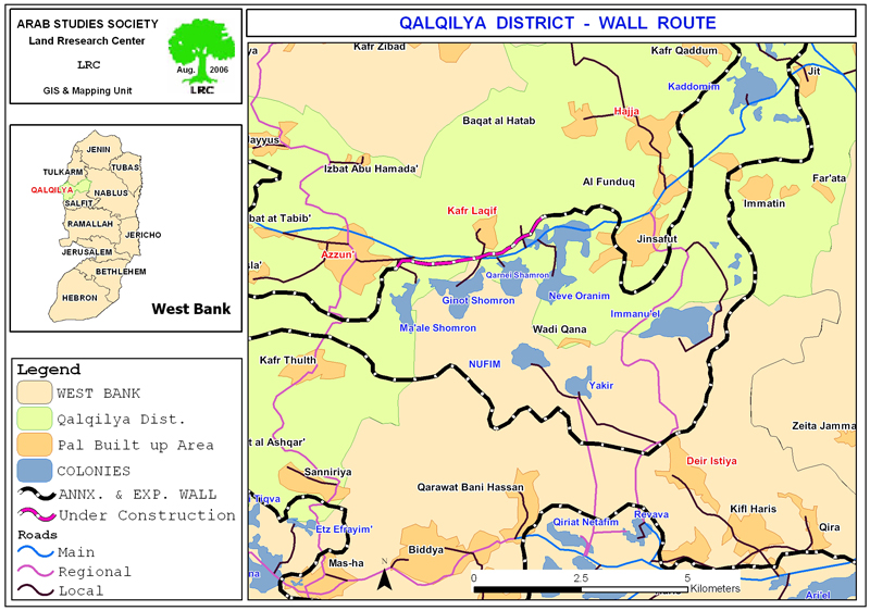
The biggest finger �like corridor

The Wall route is planned to pass through the lands of these four Palestinian villages so as to complete the bordering of the biggest finger-like corridor in the West Bank which aims at ensuring the annexation of all Israeli colonies in the area. This finger- like corridor of Ariel settlement block includes15 colonies: Ariel, Yakir, Revava, Keryat Netafim, Neve Oranim, Karne Shomron, Ginnot Shomron, Ma'ale Shomron, Immanuel, Nufim,  Barqan, Alei Zahav (Yo'ezer), Pedu'el, Beit Arie and Ofarim.


This corridor will result in the annexation of thousands of dunums of Palestinian lands and dozens of underground water wells which, in effect, will cause disastrous impact on the very existence and welfare of Palestinian people in the area.  Works in this corridor started at the beginning of 2003.


(Map 2: the biggest finger-like corridor in the Wet Bank )


The following are some of the impacts caused or to be caused as a result of this colonial project:

1.     Bulldozing thousands of dunums of olive orchards considered to be the only source of living for Palestinian families, particularly, after loosing jobs inside Israel;

2.     The difficulty of accessing into agricultural lands which have been already separated behind the Wall;

3.     Giving Israeli settlers in the area a wide scale space of land for expansion and development at the expense of Palestinian land and future development.

4.     The above mentioned Wall section between the villages of Azzun and Kafr Laqif will cut main road number 55 linking between the cities of Qalqiliya and Nablus. The Palestinian movement on this road will be under the mercy of the Israeli army who plan to establish a permanent checkpoint comprised of an iron gate and watch towers. 8 dunums of land were confiscated from kafr Laqif village for the establishment this checkpoint and a military base (military decree number T/62/06 dated on July 26, 2006). Once established, no Palestinian will be able to pass through without having valid passing permits from the Israeli military. 


Prepared by
The Land Research Center
LRC 


Recommended For You

إغلاق مداخل قرية دير نظام بالتزامن مع إقامة مقطع جديد من السياج الفاصل / محافظة رام الله

by arij
June 25, 2019
0
The Israeli occupation violates human rights in Deir Nitham / Ramallah governorate

  الانتهاك: إقامة مقطع جديد من السياج الفاصل وإغلاق مداخل القرية. الموقع: قرية دير نظام شمال مدينة رام الله. تاريخ الانتهاك: 13/02/2019. الجهة المعتدية: جيش الاحتلال الإسرائيلي. الجهة...

Read moreDetails

The Israeli occupation violates human rights in Deir Nitham / Ramallah governorate

by arij
June 25, 2019
0
The Israeli occupation violates human rights in Deir Nitham / Ramallah governorate

  Violation: closing the town’s entrance and establishing a new segment of the apartheid wall. Location: Deir Nitham village north Ramallah city. Date: 13/02/2019. Perpetrator:  The Israeli occupation...

Read moreDetails

Info-graph: Manipulating the Demography of Occupied East Jerusalem
“The Construction of the Israeli Segregation Wall in and around Jerusalem

by arij
January 16, 2019
0
Info-graph: Manipulating the Demography of Occupied East Jerusalem “The Construction of the Israeli Segregation Wall in and around Jerusalem

  When Israeli captured East Jerusalem along with other Arab-Palestinian territories during the 1967 war, it became an obsession of the successive Israeli governments to win the demographic...

Read moreDetails

جيش الاحتلال الاسرائيلي ينصب بوابة حديدية جديدة شمال مدينة سلفيت

by arij
July 3, 2018
0
جيش الاحتلال الاسرائيلي ينصب بوابة حديدية جديدة شمال مدينة سلفيت

  الانتهاك: نصب بوابة حديدية على مدخل طريق زراعي شمال سلفيت. الموقع: مدينة سلفيت.. تاريخ الانتهاك: 21 حزيران 2018م. الجهة المعتديه: جيش الاحتلال الإسرائيلي. الجهة المتضرره: المزارعون في...

Read moreDetails

Israel to build new segment of the apartheid wall around “Ma’ale Isreal”

by arij
December 10, 2018
0
Israel to build new segment of the apartheid wall around “Ma’ale Isreal”

violation: completing the construction of the apartheid wall Location: Sarta Ash-Sharqiya village/ Salfit Governorate. Date:  May 01 - 2018 Perpetrators: Israeli Occupation Forces Victims:  residents of Sarta Description:...

Read moreDetails
Next Post
Land confiscated for military base and permanent checkpoint in Kafr Laqif

Land confiscated for military base and permanent checkpoint in Kafr Laqif

LATEST NEWS

الأراضي الفلسطينية بين الذرائع الأمنية والأطماع الاستيطانية – “الأمن، الآثار، والطبيعة كحجج لاقتلاع الفلسطينيين من أراضيهم”

by arij
April 15, 2025
0

........................................................

الطرق الالتفافية الاسرائيلية وأثرها على البيئة الفلسطينية

انتهاك للطبيعة والهوية في الأراضي الفلسطينية المحتلة

by arij
March 17, 2025
0

........................................................

Israel Advances Settlement Plan on Ancient Olive Groves on lands of Beit Jala city, Violating International Law and depriving Palestinians their lands

إسرائيل تمضي قدمًا في مخطط استيطاني جديد على أراضي مدينة بيت جالا، في انتهاك للقانون الدولي وحرمان الفلسطينيين من أراضيهم

by arij
April 29, 2025
0

........................................................

Israel Advances Settlement Plan on Ancient Olive Groves on lands of Beit Jala city, Violating International Law and depriving Palestinians their lands

Israel Advances Settlement Plan on Ancient Olive Groves on lands of Beit Jala city, Violating International Law and depriving Palestinians their lands

by arij
April 29, 2025
0

........................................................

flag_yellow_lowEU-PfP-Logo

This website has been produced with the assistance of the European Union. The contents of this publication are the sole responsibility of ARIJ & LRC and can in no way be taken to reflect the views of the European Union.

© 2025 Copyright ARIJ . All Rights reserved. .

No Result
View All Result
  • Home
  • Settlements
    • New Israeli Settlements
    • Settlement Expansion
  • Israeli Violations
    • Agriculture
    • Confiscation
    • Demolition
    • Environment
    • Eviction of Palestinians
    • Settlers Attacks
  • Bypass Roads
  • Israeli Plans
  • Segregation
    • Checkpoints
    • Closure
    • Separation Plans
  • Military Orders
  • Reports
    • Daily Report
    • Monthly Report
    • Quarterly Report

© 2025 Copyright ARIJ . All Rights reserved. .