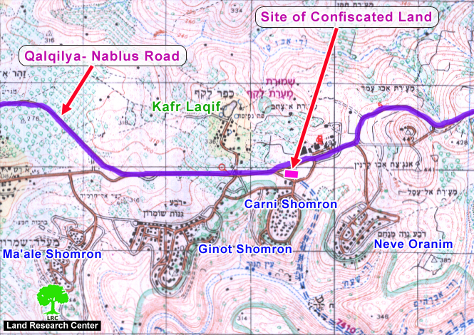
The Israeli occupation forces decided to confiscate 8 dunums of land from Kafr Laqif and Hajja village/ Qalqiliya governorate for the purpose of establishing a military base and permanent checkpoint on the main road between Nablus and Qalqiliya near the settlement of karne Shomron.
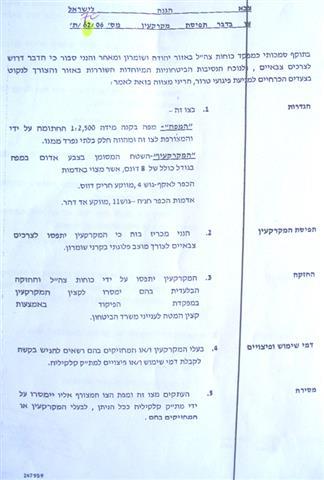
A military decree was issued in this regard by the commander of the Israeli occupation forces in the West Bank, General Ya'ir Neve, dated July 26th, 2006, and carrying the number T/62/06. It states that because of the prevailing security situations in the area, the land will be confiscated for military purposes to prevent any 'terror operations'.
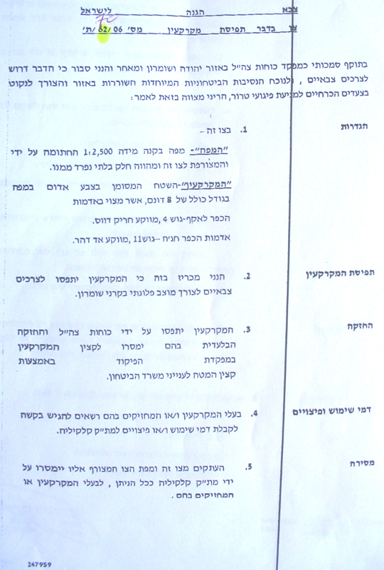

(Photos 1 & 2: copies of military order and its attached map)
According to the military decree, the following land areas will be taken:
1. Kafr Laqif village, basin 4, Hariq Dawas location;
2. Hajja village, basin 11, Adhaher location.
The above land areas are owned by the heirs of Ahamd Hilal, heirs of Haj Mohammed Masalha and heirs of Ahamd Awad.
Location, population and area
The following table provides information on the two Palestinian villages by Location, population and area:
|
No |
Village name |
Location |
Population |
Area in dunum |
|
|
|
|
|
|
Total |
Built up |
|
1 |
Hajja |
Qalqiliya |
2000 |
11717 |
932 |
|
2 |
Kafr Laqif |
Qalqiliya |
750 |
2579 |
298 |
Source- the GIS unit at LRC.
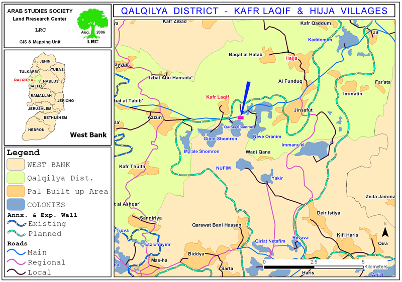
Annexation and Expansion Wall in the area
The confiscation of these eight dunums came as part of the plan for the construction of the Annexation and Expansion Wall in the area. Works in the construction of the Wall in this part of the region were resumed this week in a 2800 meters long section between Azzun and Kafr Laqif on the main Nablus- Qalqiliya road number 55 over 279 dunums of Palestinian owned land.
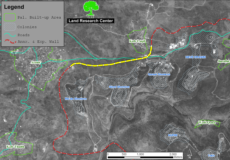
(Satellite image 1: the yellow section of the Wall currently under construction)
The above mentioned Wall section will cut the main road number 55 and allow Palestinian passage through the planned checkpoint which will be comprised of an Iron Gate and watch towers. Consequently, the Palestinian movement will be put under the mercy of Israeli soldiers manning this checkpoint who won't allow Palestinian passage unless proper passing permits are obtained from the Israeli military.
The Wall plan in this section encompasses the annexation of four settlements, namely: Ma'ale Shomron, Ginot Shomron, Karne Shomron and Neve Oranim which are located in the most north eastern biggest finger-like corridor in the West Bank which aims at ensuring the annexation of all Israeli colonies in the area. This finger- like corridor of Ariel settlement block includes another 11 settlement: Ariel, Yakir, Revava, Keryat Netafim, Immanuel, Nufim, Barqan, Alei Zahav (Yo'ezer), Pedu'el, Beit Arie and Ofarim.
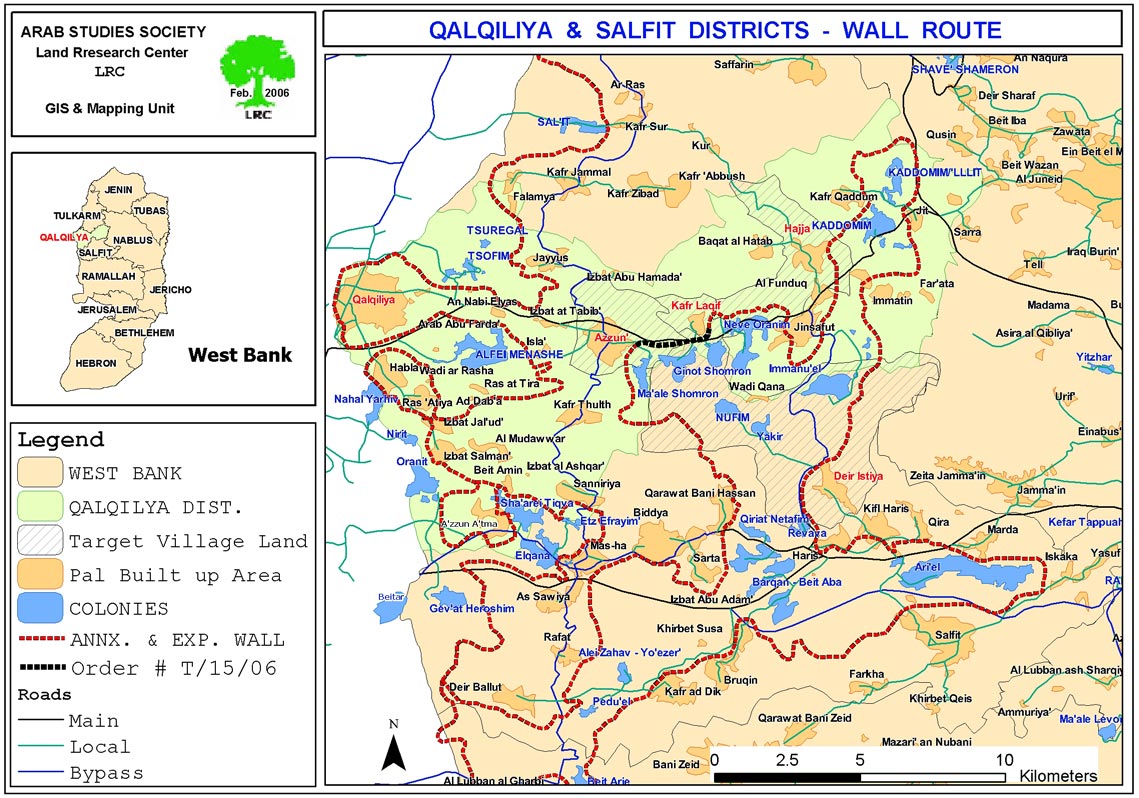
Insert map 3: the Ariel corridor
This corridor will result in the annexation of thousands of dunums of Palestinian lands and dozens of underground water wells which, in effect, will cause disastrous impact on the very existence and welfare of Palestinian people in the area. Works in this corridor started at the beginning of 2003.
Prepared by
The Land Research Center
LRC