Qatanna village: Location and Population
Qatanna, a Palestinian village located 12 Kilometers to the northwest of Jerusalem city, has an area of 3555 dunums and is 650 meters above sea level. The village population is currently around 7711 (PCBS 2005) with 677 dunums of built-up area. Qatanna is surrounded by the Palestinian villages of Biddu, Beit 'Anan, Beit Liqya and some hamlets such as Al Nijem, Umm Al Lahem and Al Kafara.
Before the 1948 war, Qatanna village had an area of 16529 dunums of which 12974 dunums were taken over by the Jewish Haganah during the war, leaving only 3555 dunums for the village. According to Qatanna's village council, about 70% of Qatanna’s residents are refugees, coming from kherbit Al Buwayra which was destroyed by the Haganah during the 1948 war and its residents were forced to leave their village and were not able to return to their homes and lands. Later on, when the armistice agreement was signed between the Jordanian and Israeli sides, 1489 dunums out of the 3555 dunums of Qatanna’s lands were identified as 'No Man’s Land'. The UNTSO peacekeeping forces (United Nations Truce Supervision Organization) were situated in the 'no man's land' to limit the friction along the Armistice line (Green line) between the parties.
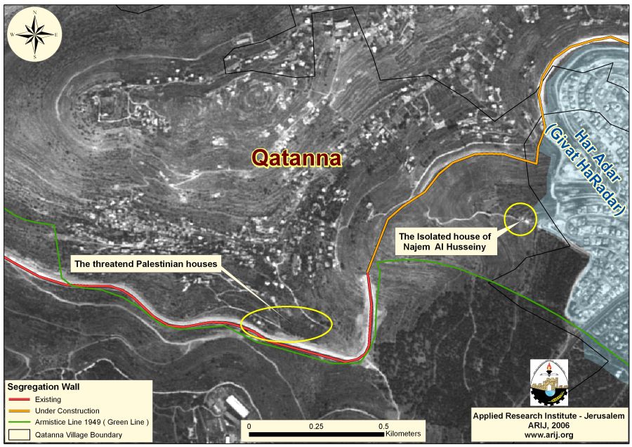
Furthermore, in 1986 the Israeli government confiscated about 66 dunums of Qatanna lands in order to establish the illegal Israeli settlement of Har Adar (Giv'at HaRadar) which hosts 2100 Israeli settlers (Peace now, 2005) and spreads over 1193 dunums of lands. See Map 1

In the Oslo II Interim Agreement that was signed in September 1995 between the Palestinians and Israelis, the Palestinian areas in the West Bank were categorized into three areas A (where the Palestinians have control over administrative and security issues), B (Palestinians have full control over the civil responsibilities and Israel continues to have overriding responsibility for security) and C (Israel retains full control over security and administration related to territory). Accordingly, A total of 716 dunums of Qatanna’s lands were classified as Area B; while the rest of the area, a total of 2839 dunums were classified as Area C.
Services and facilities in Qatanna village
Qatanna village is considered among the Palestinian villages that have adequate social services, as it has three schools, three kindergartens, three clinics, one medical center that is supervised by the Palestinian Red Crescent society and one pharmacy. The village has also one sport club and one women center, (Qatanna Village Council 2006). Jerusalem was the main urban provider for villages located northwest of it (Qatanna is one of them), where the villagers used to market their agricultural products and utilize the medical, educational and commercial centers there. However, during the 1990s and after the Israeli government started implementing the closure policy around Jerusalem, the villagers were no longer able to access Jerusalem unless they have special permits, Ramallah has therefore became the main Urban provider for these villages.
Qatanna village and the Segregation Wall
Since the Israeli occupation of the West Bank and the Gaza Strip in 1967, the Israeli authority implemented its colonization project which is marked by confiscating Palestinian lands, uprooting trees and demolishing houses in order to construct and expand the illegal Israeli settlements and outposts. Today, Israel is solidifying this confiscation by constructing the Segregation Wall in the West Bank.
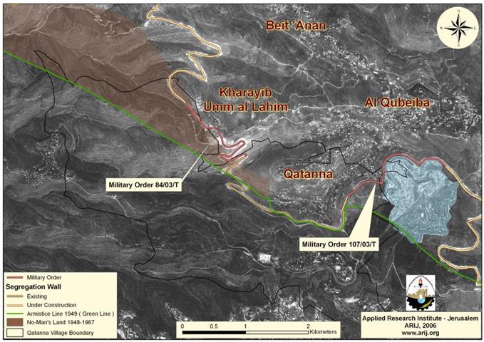
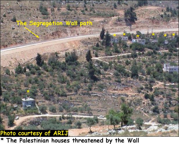
On December 9, 2003, the Israeli forces handed the residents of Qatanna military order number (84/03/T) to confiscate 192.2 dunums of lands from the Palestinian villages of Qatanna and Al Qbeiba in order to construct the so called 'Segregation Wall', of which 106 dunums are located within Qatanna's village boundary. Moreover, another military order holding # (107/03/T) was issued by the Israeli authorities on December 31, 2003, to confiscate 238.4 dunums of lands from Qatanna, Biddu, Beit Surik and Al Qbeiba villages, whereby 47 dunums of them are to be taken from Qatanna's land. The Segregation Wall in Qatanna village will reach a length of 4.695 Kilometers of which 2.408 Km already exist and the rest 2.287 Km is currently under construction.See Photos of the Segregation Wall in Qatanna Village

More than 70% of the villagers who used to work in Israel became unemployed due to the Israeli closure of the area after the construction of the Segregation Wall.
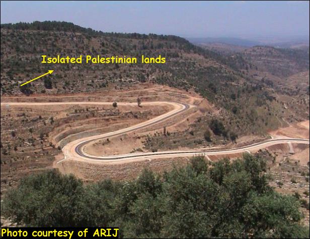
Nearly 43% of Qatanna lands will be totally isolated behind the Segregation Wall
The Segregation Wall which Israel is currently constructing in Qatanna will totally isolate 43% (1512 dunums) of lands south of (behind) its path leaving only 2043 dunums for the village future expansions.
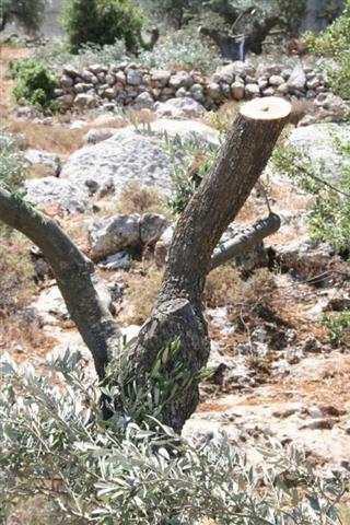
The village's major cultivations are Olive, Prune and figs trees. However, 40% of the Permanent crops that lies on the lands of Qatanna will entirely be isolated behind the Wall's path and villagers will no longer be able to access them. Also, 32% of the open space and 90% of the shrub or herbaceous vegetation associations in the village will be isolated, which impose pediments to the future development of the village.
Table 2 below shows the land classification inside the village boundary and the lands that will be isolated behind the Wall. See map of the Wall and the LULC.
Table 2: Land Use/Land Cover in Qatanna Village
|
Land classification: Land Use/Land Cover
|
LULC inside the village boundary of Qatanna |
LULC in the area isolated by the Wall(south of the Wall) |
Percentage |
|
Arable land |
5 |
0 |
0 |
|
Open spaces with little or no vegetation |
963 |
306 |
32% |
|
Permanent crops |
1074 |
429 |
40% |
|
Shrub and/or herbaceous vegetation associations |
758 |
680 |
90% |
|
Forest |
9 |
9 |
100% |
|
Palestinian Built-up area |
683 |
0 |
0 |
|
Israeli settlement |
63 |
63 |
100% |
|
|
|
|
|
|
Total |
3555 |
1512 |
43% |
Source: ARIJ database- GIS, 2006
There are four springs in the village, Al Balad, Al Samra, Al Namous and Al Nimr. It is worth mentioning that Al Namous spring will be totally isolated from Qatanna due to the construction of the Segregation Wall.
Access to Qatanna village
The road leading from Qatanna to Ramallah passes through the Palestinian villages of Al Qbeiba, Biddu, Al Nabi Samuel and then connects with bypass roads 443 and 45 to reach Qalandia and then to Ramallah, this route used to take approximately 20 minutes. Nowadays and since a substantial part of the Segregation Wall in the area is already constructed and after Atatot terminal (Qalandiya terminal) is functioning, the villagers of Qatanna are forced to use alternative roads in order to reach their destinations. Qatanna villagers going to Ramallah city have to go through the Palestinian villages of Al Qbeiba, Biddu, Beit Surik, Beit Iksa, Beit Hanina Al Balad, Beir Nabala and Al Jeeb which takes more than an hour to reach.
Qatanna and the Israeli violations
Since the eruption of the second Intifada on September 2000, until today the Israeli forces demolished about 418 Palestinian houses in Jerusalem city and the surrounding villages (in Jerusalem Governorate). Qatanna village has been one of the villages targeted repeatedly by this Israeli policy of house demolition either under the pretext of being unlicensed or for the Segregation Wall process.
On May 30, 2006, the Israeli reconciliation court handed seven Palestinian owners from Qatanna village military warnings in order to demolish their houses under the pretext of being unlicensed and of being constructed on lands owned by the State of Israel. The houses belong to Emad Al Qatanany, Yasir Hamad Tah, Jamal, Ja'far, Musa, 'Abed El Fatah, Muhammad and Yousif Ahmad Al Faqeeh. It is worth to point out that residents obtained in 1979 the proper licenses from the Israeli Civil Administration of Beit El in Ramallah Governorate, which means that the building process followed the legal procedures and there were no ownership claims by the Israeli government and no restrains to obtaining the licenses.
This case is an old-new one, since 1980 until today the Israeli authorities handed series of orders to the same families asking them to carryout the demolition orders on their own under the same aforementioned pretexts, which as a result would cost them huge amounts of money and would leave about 60 inhabitants homeless most of them are children.
The Palestinian residents raised petitions to the Israeli court proving their ownership of the houses and lands. Years passed by and the residents are receiving the same orders for same pretexts. It is worth mentioning that the Israeli Segregation Wall in the village is located 3 meters away from the threatened houses. Moreover, the 144 m² house of Najem El Din Taher Al Husseiny which is located on the eastern edge of the village will totally be isolated behind the Wall path and the 19 family members will no more have access to the village. This house was constructed in 1972 and contains 4 rooms, kitchen and a bathroom. Today, the Israeli forces cut the water supply to the house of Najem El Din in an attempt to force him to leave his house. See Photos of threatened Houses
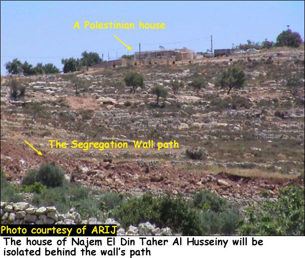
The IOF also prohibits him from building any additional units or constructions to the house and rejects paving or letting him pave the only street leading to the house. It is worth to point out that this house is threatened either of demolition or to be attached to the nearby Israeli settlement of Har Adar due to its proximity to the settlement. See Map of houses
Conclusion
The construction of the Wall in the heart of the West Bank caused the demolition of hundreds of Palestinian houses which were located along the Wall's path. The Israeli aggressive violations in the Palestinian Territory contradict and breach the international laws and the fourth Geneva Convention: (August 12, 1949): CONVENTION (IV) RELATIVE TO THE PROTECTION OF CIVILIAN PERSONS IN TIME OF WAR:
Article 53: Any destruction by the Occupying Power of real or personal property belonging individually or collectively to private persons, or to the State, or to other public authorities, or to social or cooperative organizations, is prohibited, except where such destruction is rendered absolutely necessary by military operations.
The Israeli government continues to create more facts on the ground by demolishing more Palestinian houses and grabbing more lands for constructing and expanding the illegal Israeli settlements.
Prepared by
The Applied Research Institute – Jerusalem
ARIJ