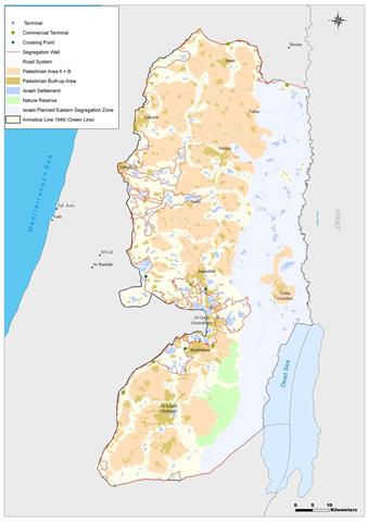
The Israeli Government endorsed on April 30, 2006, an updated Wall plan which included changes in a number of locations which constituted major obstacles to the resumption of Wall construction in the West Bank. The changes were obvious in Al Jab'a village southwest Bethlehem city, Al Walajeh Village northwest Bethlehem city, Beit Iksa Village Northwest Jerusalem City and the Ariel Settlement bloc in Salfit. The Government also ordered the resumption of Wall constructions around Jerusalem City, or the so called 'Jerusalem Envelope' and the Ma'ale Adumim bloc of settlements. See Map 1 (Wall Change)

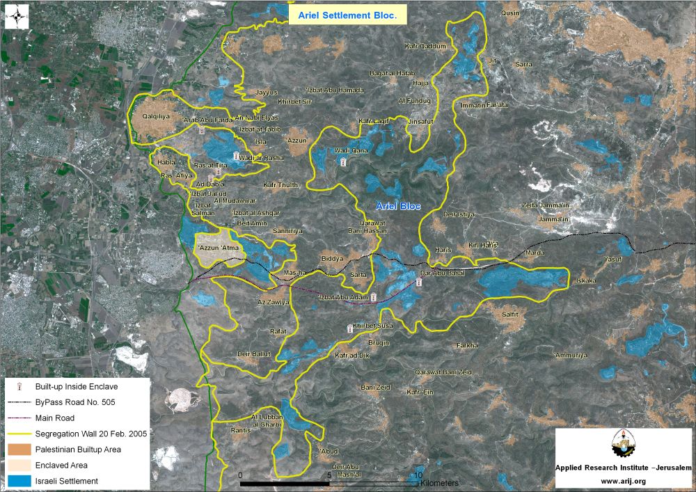
The Ariel settlement bloc
The Ariel settlement is considered the second largest settlement bloc established in the West Bank after Ma'ale Adumim. It is comprised of 26 Israeli Settlements; most of which were established during the late seventies and early eighties on lands that were confiscated from the Palestinian Villages of Kafr Qaddum, Qussein, Jit, Hajja, Immatin, Azzun, Al Fanduqimyia, Kafr Laqif, Jinsafut, Deir Istiya, Kafr Thuluth, Kifl Harith, Biddya, Qarawet Bani Hasan, Qira , Marda , Masha, Haris, Sarta, Iskaka, Zawiya, Salfit, Buruqin, Farkha, Kafr Dik, Deir Ballut, Ranttis, Kherbit Mismar, Deir Ghassana, El Lubban, and 'Aboud following the 1967 war.
The settlements comprising the Ariel Bloc are Ariel, Beit Arye, Barqan industrial Zone, Israeli Quarry, Ginnot Shomeron, Immanuel, Karne Shomron, Kedumim, Ma'ale Shamron, Yakir, Barqan, Nofim, Ofarim, Giv'at HaMerkaziz, Peduel, Neve Oramin, Har Alei Zahav, Revava, Kiryat Netafim, Alei Zahav (Yoezer), Kedumim Zefon, Jit, Industrial Zone (Near Peduel), South West Arial, Ariel West Park Industrial, West (Arial West Park Industrial).
The 'Ariel Finger' – the Israeli Segregation Wall Plan around Ariel Settlement Bloc
The 'Ariel finger' penetrates deep inside the northern part of the West Bank, about 22 km east of the 1949 Armistice Line, (ARIJ GIS, 2005). The Israeli updated Wall map of February 20, 2005 which were published on the Israeli Ministry of Defense website showed that the Wall around Ariel bloc stretches for 114 km and seizes within it a total of 120,000 dunums of lands (120 km²), where about 18 % of these lands are occupied by the Settlements' area. Table 2 below details the land use land cover of the lands isolated inside the Ariel Finger. showed that the Wall around Ariel bloc stretches for 114 km and seizes within it a total of 120,000 dunums of lands (120 km²), where about 18 % of these lands are occupied by the Settlements' area. below details the land use land cover of the lands isolated inside the Ariel Finger.
Table 2: Land Use Land Cover of Ariel Finger
|
Land Use Land Cover |
Area in Dunums |
Area in Km² |
% of the Total area |
|
Settlement Built-up area |
21600 |
21.6 |
18% |
|
Agricultural areas |
46800 |
46.8 |
39% |
|
Forested areas |
13200 |
13.2 |
11% |
|
Areas with shrubs |
13200 |
13.2 |
11% |
|
Open Spaces |
25200 |
25.2 |
21% |
|
Total |
120000 |
120 |
100% |
Source: ARIJ- GIS database 2005
The Area the Ariel finger was about to encompass according to February 20, 2005 maps, was larger than the area the other settlement blocs encompass, as the Segregation Wall around Ma'ale Adumim bloc encompasses an area of 61,286 dunums and the Wall around Gush Etzion bloc encompasses an area of 72,423 dunums. See Map 1
The Division of Ariel Finger
The Israeli Government Wall update of April 30, 2006 showed that Ariel Finger is to be divided into two, the Ariel finger and the Kedumim finger. The Ariel Finger will encompass 14 Israeli settlements housing more than 24000 Israeli settlers, including three industrial Zones. It will also occupy a total area of 57.5 km² where the wall will stretch a length of 81.5 km around it. See Table 3
Table 3: Settlements inside Ariel Finger
|
Settlement Name |
Year of est. |
Governorate |
Area in Dunums (2004) |
|
Ariel |
1978 |
Salfit |
5200 |
|
Beit Arye |
1981 |
Ramallah |
1420 |
|
Barqan industrial Zone |
1981 |
Salfit |
1420 |
|
Barqan |
1981 |
Salfit |
649 |
|
Ofarim |
1988 |
Ramallah |
545 |
|
Peduel |
1984 |
Salfit |
540 |
|
Har Alei Zahav |
1983 |
Salfit |
489 |
|
Revava |
1991 |
Salfit |
399 |
|
Kiryat Netafim |
1982 |
Salfit |
387 |
|
Alei Zahav (Yoezer) |
1982 |
Salfit |
352 |
|
South West Ariel |
2003 |
Salfit |
100 |
|
Industrial Zone (Near Peduel) |
1991 |
Salfit |
246 |
|
Ariel West Park Industrial |
1991 |
Salfit |
1906 |
|
West (Arial West Park Industrial) |
NA |
Salfit |
9 |
Source: ARIJ GIS Database 2005
In addition, the Ariel Bloc will be linked to the nearby settlements (Shaare Tikva, Mazor Atiqa (Israeli Quarry), Benot Orot Yisra'el, Elkana, Oranit, Etz Efrayim and Zamarot) and to Israel through Bypass Road number 5 (see annex 1) which is under the full Israeli Control (Palestinians are completely prohibited from using this road).
Table 4: Settlements added to Ariel Finger after Aprilâ??s update
|
No. |
Settlement Name |
Governorate |
Est. Date |
Area in Dunums |
|
1. |
Benot Orot Yisra'el |
Salfit |
1989 |
158 |
|
2. |
Elkana |
Salfit |
1977 |
1513 |
|
3. |
Etz Efrayim |
Salfit |
1985 |
566 |
|
4. |
Oranit |
Qalqiliya |
1983 |
1289 |
|
5. |
Shaare Tikva |
Qalqiliya |
1982 |
1063 |
|
6. |
Zamarot |
Qalqiliya |
1985 |
310 |
|
7. |
Mazor Atiqa (Israeli Quarry) |
Salfit |
1986 |
688 |
Road 5 will be protected from both sides with fences as to provide security to Jewish settlers accessing the road. While Kedumim Finger, will occupy a total area of 45.5 km² and will encompass a total of 12 Israeli settlements within it and housing more than 19000 Israeli Settlers; where the Wall will stretch a length of 51.5 km around it. Table 5 details the Israeli Settlements that the planned Kedumim finger will encompass.
Table 5: Settlements inside Kedumim Finger
|
No |
Settlement Name |
Date of establishment |
Governorate |
Area in 2004 (dunums) |
|
|
1 |
Ginnot Shomron (a neighborhood in Karnei Shomron) |
1985 |
Salfit |
1047 |
|
|
2 |
Immanuel |
1981 |
Qalqilyia |
1045 |
|
|
3 |
Karne Shomron |
1978 |
Qalqilyia |
1024 |
|
|
4 |
Nofim |
1986 |
Salfit |
641 |
|
|
5 |
Kedumim |
1975 |
Qalqilyia |
986 |
|
|
6 |
Ma'ale Shamron |
1980 |
Qalqilyia |
752 |
|
|
7 |
Giv'at HaMerkaziz |
NA |
Qalqilyia |
543 |
|
|
8 |
Neve Oramin |
1991 |
Qalqilyia |
538 |
|
|
9 |
Kedumim Zefon |
1982 |
Qalqilyia |
318 |
|
|
10 |
Yakir |
1981 |
Salfit |
701 |
|
|
11 |
Jit |
NA |
Qalqilyia |
275 |
|
|
12 |
Alfe Mensahe |
1981 |
Qalqilyia |
2905 |
Source: ARIJ GIS Database 2005
The Kedumim finger will be linked with the Israeli settlement of Alfe Menashe (located southeast of Qalqilyia city) and then to Israel.
The redrawing of the Segregation Wall path around Ariel bloc (Division of Ariel Finger) has increased the length of the Wall from 120 km to 133 km which is the total Wall length around Ariel and Kedumim fingers. See Map 1

Consequences resulted by the division of Ariel Finger
The division of the Ariel finger into two fingers has resulted in the isolation of tens of Palestinian villages and hamlets located within the fingers and in the area segregated between them.
- According to the analysis conducted by the GIS unit at the Applied Research Institute â?? Jerusalem (ARIJ), the area between Ariel and Kedumim fingers which includes 15 Palestinian communities (housing about 35,448 residents (PCBS 2005)) will be surrounded with walls from three directions (west, north and south) except for the eastern direction which will be their only entrance/exit to the neighboring Palestinian Villages located outside the ghetto; the communities are Habla, Ras Tira, Ras 'Attiya, Kafr Thuluth, Ad Dab'a, Al Mudawwar, Bidya, 'Isbat Al Ashqar, Qarawet Bani Hassan, Beit Amin, Mas-ha, Sarta, Sanniryia, 'Izbat Jal'ud and 'Izbat Salman.
- Three Palestinian hamlets housing a total population of about 70 persons will be isolated inside the Ariel finger. The hamlets are Khirbet Susa (13 people), Dar Abu Basal (6 people) and 'Izbat Abu Adam (47 people). Most likely that these three communities will be forced to evacuate their areas once the Wall is completed in the area.
- While Kedumim finger will isolate within it another 3 Palestinian communities, Wadi Qana (70 people), Arab Abu Farde (77 people) and Wadi Ar Rasha (101 people). Those three communities will face the same fate that the other communities isolated (according to the plan) within the Ariel Finger, the forcible eviction.
- The division of Ariel finger into Ariel and Kedumim fingers according to the Israeli maps will limit the future expansion of the 15 Palestinian villages mentioned earlier; in addition it will affect their mobility as they no longer will be able to use their usual routes to reach their destinations as they used to be.
- The Palestinian Village of Azzun El 'Atmeh (population 1614, PCBS 2005) will also be entrapped in an enclave that will isolate it from the neighboring Palestinian villages; the village (according to the updated wall map) will be surrounded with walls from all directions. The fact that the village is surrounded from three directions with Israeli Settlements (East, West and South), makes the village's northern entrance the only entrance/exit that might be effective for villagers to use in the future and most probably that their only access to the neighboring communities will be controlled by the Israelis. See Map 1
- While the Palestinian villages of Az Zawiya, Rafat and Deir Ballut will be trapped in another enclave since the Wall will surround them from all directions. It is believed that an underground road (below Bypass Road 5) will be constructed as to link the three Palestinian villages with the closest neighboring Palestinian communities in the north, south and southeast. The three Palestinian villages house a total population of 10435 people and their movement will be totally affected.
Conclusion
The updated Israeli Wall map has caused the creation of more Palestinian enclaves and will add more difficulties to the Palestinian living in the nearby communities, since the change by no means, serves them, but rather, serves the Israeli settlers living in the nearby Israeli settlements; in addition, it will cause the confiscation of an additional area of land, depriving Palestinians their opportunity to expand and prosper in the future.
The construction of the Israeli Segregation Wall is flagrant violation to the rights of Palestinians assigned to them by the international law and Human Rights laws such as the International Covenant on Civil and Political Rights and the International Covenant on Economical, Social, and Cultural Rights both of which Israel has signed.
The Freedom of Movement is highly affected by the construction of the Segregation Wall as the wall is imposing new routes on Palestinians that are longer in time and money consuming. The Right to Freedom of Movement is protected by Article 12 of the International Covenant on Civil and Political Rights (ICCPR), which states: 'Everyone lawfully within the territory of a State shall, within that territory, have the right to liberty of movement and freedom to choose his residence.
Other rights are contingent upon freedom of movement and also protected in their own right. For instance, the right of access to healthcare is protected by Article 12 of the International Covenant on Economic, Social and Cultural Rights (ICESCR); the right to education is protected under Article 12 of the ICESCR and Article 26 of the Universal Declaration of Human Rights (UDHR); the right to freedom of religion is protected under Article 18 of the ICCPR; the right to work is protected under Article 6 of the ICESCR; the right to food and water is protected under Article 11 of the ICESCR and Article 26 of the UDHR; and other rights also fall under various aspects of human rights law.
Annex 1
Bypass Road number 5 intersects with bypass Road 505 at Haris village lands and heads south towards the Industrial zones inside Ariel Bloc (Barqan and West (West Park Industrial Zone)), passing through the lands of Sarta and Mas-ha villages serving the settlements of Sha'ar Tekva and Elkana and finally connecting with Israel. The Bypass road is 15.1 km long.
References:
- PCBS, Palestinian central Bureau of Statistics. 20 Aug 2005. Palestinian central Bureau of Statistics. <http://www.pcbs.gov.ps/>.
- The Palestinian Hydrology Group. Retrieved June 13, 2006, from The Water and Sanitation Hygiene Monitoring Project Web site: http://www.phg.org/campaign/QueriesSystem.aspx
Prepared by
The Applied Research Institute – Jerusalem
ARIJ


