Prelude
In 2002, the Israeli Government adopted a plan to construct a system of walls and fences in the Occupied Palestinian Territory. Immediately after adopting the plan, the Israeli civil administration started issuing military orders under various pretexts for seizing Palestinian lands needed for constructing the wall. So far, more than 200 Israeli military orders were issued in all West Bank Governorates stating the confiscation of Palestinian lands for constructing the Segregation Wall and resulted in massive damage to the livelihood of Palestinians and dramatically impaired the infrastructure of Palestinian villages and towns.
The Status of the Wall in the West Bank
A study conducted by the GIS unit at the Applied Research Institute – Jerusalem showed that the total length of the Wall, according to the latest revised Wall map published on the IDF website on February 2005 and to the military orders that were issued, is 683 kilometers; where only 183 kilometers Wall out of the total length run on the 1949 Armistice Line (Green Line).
As of the end of year 2005, 244 kilometers (36% of the total length) of the Segregation Wall has penetrated the lands of the West Bank Governorates and is already obstructing (directly or indirectly) the daily lives of thousands Palestinians living inside and outside the segregated areas (West and east of the Segregation Wall). A total of 116 kilometers is under construction (17% of the total wall length), while 323 kilometers (47% of the wall length are planned to be constructed.
Once completed, the Wall will segregate 576 km² of the Palestinian land in the western segregation zone (approximately 10% of the total West Bank area – 5661 km²). It will also enclose 98 Israeli settlements which accommodate about 83% of the total Israeli settlers' population in the West Bank, in addition to 55 Palestinian communities. Additionally another 1664 Km² (29.4% of the West Bank Area) will be segregated in the eastern segregation zone where the segregation is maintained by blocking access on all roads that lead to the Jordan valley and western shores of the Dead Sea. The eastern segregation zone encloses 43 illegal Israeli settlements and 42 Palestinian communities.
A buffer Zone along side the Segregation Wall – at the Palestinian Side
In September 2004, the Israeli Occupation Forces issued military orders to create a buffer zone averaging from 150 to 200 meters on the Palestinian side of the Segregation Zone where new constructions are prohibited. As a result, an additional 252 km² of the West Bank (4.4 %) will become inaccessible to Palestinians.
Status of petitions against the construction of the Segregation Wall
A wave of petitions were filed to the Israeli high court by Palestinian residents and Village councils in West Bank Governorates rejecting the route of the segregation Wall and demanding Israel to abolish it or if it insists to build it, to position it on the Green Line or westwards. Palestinians were also objecting the desperate living conditions and property damages the existing Wall sections had caused them and the tremendous losses it will cause once fully constructed. In addition, the Wall has been subjected to several changes during its course of construction, table 1 below details the changes that have been made to the route of the Segregation Wall since its inception in June 2002.
Table 1: Changes made to the Wall route since June 2002 till February 200
|
Date |
Wall Length |
Area segregated |
Percent |
On the Green Line |
|
June 2002 |
734 |
1024 km² |
18 % |
|
|
June 2004 |
645 with some exclusions |
633 km² |
11.7 % |
83 km |
|
February 2005 |
683 |
576 km² |
10 % |
138 km |
Israel's High Court answer to petitions
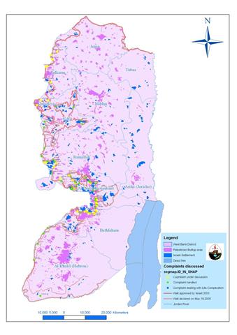
On May 2005, an updated wall plan based on 77 petitions filed by Palestinian residents and local village councils in West Bank Governorates against the construction of the Wall was published. The petitions were filed as a result of the Wall's ramification on the daily life of Palestinian residents and the long term threats it has on all life's aspects. The petitions were classified to three groups according to the cases they represent and were given colors Green, Yellow and Blue accordingly to represent the status of the petitions filed to the Israeli High Court. See Table 2 and Map 1
Table 2: Cases Filed by Palestinian Residents as classified by the Israeli Court
|
Color |
Case it represents |
|
Green |
Cases were handled by the Israeli High Court – No Further discussion. |
|
Yellow |
Cases that are still under discussion |
|
Blue |
Cases related to life complications |
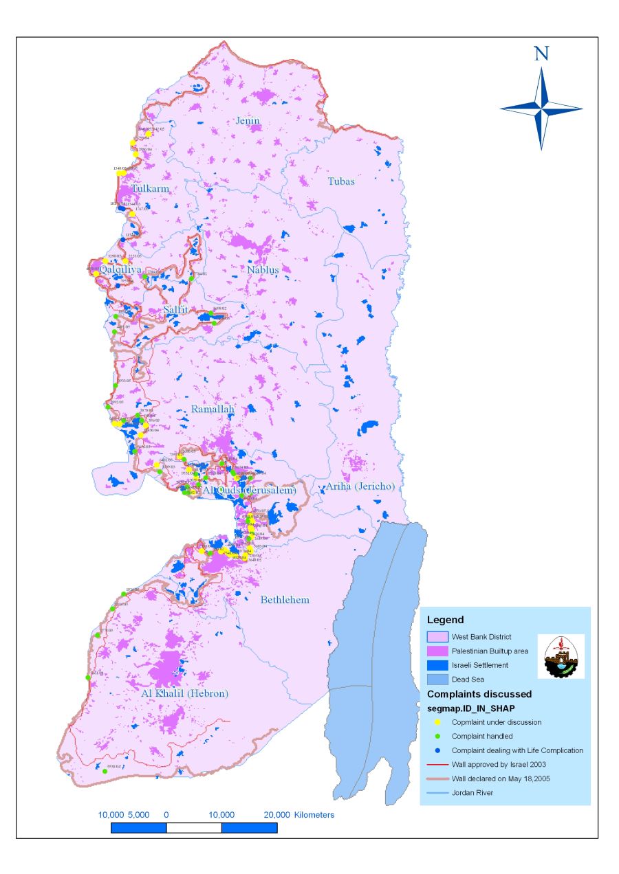
Map 1: Case Filed by Palestinian residents and villages councils
as classified by the Israeli Court
The first group of petitions included a number of Palestinian villages in the northern areas, mainly in Tulkarm and Qalqiliya. The petitions were marked with blue color on the map to signify the case they represent. See Table 3
|
Table 3: petitions presented by Palestinian Residents and village councils against the construction of Segregation Wall – cases related to life complication |
|||||
|
ID |
color |
party |
region |
year |
complaint No |
|
1 |
Blue |
Fayez Salim |
Villages: Fir'oun, Khirbet Jubara, Falamiya and Jayyus |
2003 |
11344/03 |
|
2 |
Blue |
Marab'a family |
Alfeh Menashe Settlement |
2004 |
7957/04 |
|
3 |
Blue |
Younis family |
Fir'oun |
2004 |
10278/04 |
|
4 |
Blue |
Azzun |
2005 |
2732/05 |
|
The case of Jubara
Jubara, the hamlet of 317 residents (PCBS 2005), located to the south of Tulkarm, is one of the villages that brought its case to the Israeli court due to its location isolated between the 1949 Armistice Line (Green Line) and the Segregation Wall. Works on the Wall in Kherbit Jubara were completed by October 2003 and a visible Wall line of 5.8 km runs along the eastern lands of the village and caused the loss of 590 dunums of its agricultural lands. The current standing of the wall caused to cut off a major Palestinian road (road number 574), which is considered an artery road ((runs roughly from north to south) for many small Palestinian communities who seek various services in Tulkarem city. This road cuts the village from the middle and connects with bypass Road 557 ( a complete prohiobted road where Palestinian vehicles are prevented from using it), south of Tulkarm city. Furthermore, following the eruption of the second Intifada in September 2000, the Israeli forces erected a new checkpoint on Kherbit Jubara's entrance (from the north) and restricted the movement of Palestinians going into and out of the village.
On December 2004, villagers of Jubara received a new military order number 90/04/T stating a new Wall route to be constructed along the village's eastern part. According to the military order, the Wall is to be rerouted along the western parts of the village and parallel to the 1949 Armistice line. Two months later, on February 20, 2005, the Israeli ministry of defense issued an updated Wall map which showed a new Wall route to be implemented in the West Bank.
The map did comply with the military order (90/04/T) that was distributed to residents of Jubara; however, kherbit Jubara is still imprisoned despite the court'S order to reroute the Wall which should have been implemented some 10 months ago. Israel rushes to implement military orders that are issued for either its military purposes or Wall constructions, while it sluggishly exerts the execution of a military order that might make the Palestinian movement in and out of the village better. See Map 2
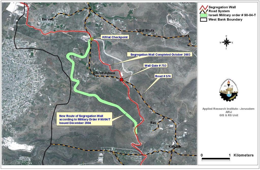
Map 2: Jubara village and the Israeli Segregation Wall
The Second group of petitions was given the color green on the map and represents the petitions filed by Palestinian residents and village councils to the Israeli High court and were handled by the court; meaning that, no longer will the court open the petitions for further discussions. It should be noted here that the petitions are not necessarily handled in favor of Palestinian citizens despite the negative effects the Wall has on people's lives. The petitions raised to the Israeli court against Wall constructions in this category were at: Rachel's Tomb area, Kherbit Mazmuria (An Nu'man village), Ar Ram Town, As Sawahreh Ash Sharqiyeh, villages located to the northwest of Ramallah city, and a number of villages in Qalqiliya and Tulkarm Governorates. Table 4 below details the petitions along with the date of the petition, and village or party involved.
|
Table 4: petitions handled by the Israeli Court (as translated from Hebrew ) |
|||||
|
ID |
color |
party |
region |
year |
complaint No |
|
1 |
Green |
Societe Fonciere de Terre-Sainte |
Jerusalem-South of Al-Ram |
2004 |
7210/04 |
|
2 |
Green |
Al Quds University |
Jerusalem Ring -Al Quds University |
2004 |
5397/04,5383/04 |
|
3 |
Green |
Hmedan |
Jerusalem Ring-Al Khas village |
2003 |
9674/03 |
|
4 |
Green |
Al Walajeh Village C |
Jerusalem Ring-Al Walajeh village |
2004 |
8659/04 |
|
5 |
Green |
Qostodiah de Terre-Sainte |
Jerusalem Ring-Beit Fagi Monastery |
2004 |
885/04 |
|
6 |
Green |
Al Daraawi |
Jerusalem – Mazmuria |
2004 |
6181/04 |
|
7 |
Green |
Abu Romi |
Jerusalem Ring – Ash Shayah |
2004 |
5743/04 |
|
8 |
Green |
Abu Thiab |
Jerusalem Ring -Olive tree Mountain |
2003 |
10204/03 |
|
9 |
Green |
Nayorookh |
Jerusalem Ring -Near Har Homa |
2003 |
10377/03 |
|
10 |
Green |
Armenian Patriarchate |
Jerusalem Ring -Near check point Gilo 300 |
2002 |
660/02 |
|
11 |
Green |
Bethlehem Municipality |
Jerusalem Ring-Rachel's Tomb |
2003 |
1890/03 |
|
12 |
Green |
Jerusalem Ring-Rachel's Tomb |
2005 |
4491/05 |
|
|
13 |
Green |
Hazboun |
Jerusalem Ring-Rachel's Tomb |
2005 |
3933/05 |
|
14 |
Green |
Mayor of Ezaryiah |
Jerusalem Ring-Monastery Region |
2005 |
2992/05 |
|
15 |
Green |
Shuqayrat |
Jerusalem Ring-As Sawahreh |
2003 |
10643/03 |
|
16 |
Green |
Abu Hadeed |
Jerusalem Ring-As Sawahreh |
2004 |
3878/04 |
|
17 |
Green |
Abu Ter |
Jerusalem Ring-As Sawahreh |
2004 |
940/04 |
|
18 |
Green |
David Jabour |
Jerusalem Ring-As Sawahreh |
2003 |
9156/03 |
|
19 |
Green |
Omar |
Shwekah – Tulkarem |
2003 |
2039/03 |
|
20 |
Green |
Al Ram village council |
2002 |
7682/02 |
|
|
21 |
Green |
Salameh |
Jayyus village |
2002 |
8532/02 |
|
22 |
Green |
Ibraheem |
Zeta |
2002 |
8172/02 |
|
23 |
Green |
Al Razeq |
'Attil |
2002 |
7350/02 |
|
24 |
Green |
Abu Aysheh |
Shwekah |
2003 |
5069/03 |
|
25 |
Green |
Al Hadi |
West of Baqa Al Sharqiyah |
2002 |
7784/02 |
|
26 |
Green |
Nasser |
Qalqiliya |
2002 |
8698/02 |
|
27 |
Green |
Sherim |
Cross Hapirot |
2002 |
7786/02 |
|
28 |
Green |
Nasser |
Kiryat Safar Ring –Saffa |
2005 |
1826/05 |
|
29 |
Green |
Yasin |
Kiryat Sefer Ring – Bil'in |
2005 |
1778/05 |
|
30 |
Green |
Abu Eid |
Biddu |
2004 |
5661/04 |
|
31 |
Green |
Samarah |
Beit 'Ur Al Foqa |
2004 |
5538/04 |
|
32 |
Green |
Beit Souriq city counncil |
Beit Surik and other villages |
2004 |
2056/04 |
|
33 |
Green |
Diab |
Kiryat Sefer Ring -Al Madina-intersects the GL |
2004 |
2626/04 |
|
34 |
Green |
Sadqa |
Kiryat Sefer Ring -Al Madina-exists in Israel |
2004 |
2384/04 |
|
35 |
Green |
Yasin |
Kiryat Sefer Ring -Bil'in |
2004 |
3062/04 |
|
36 |
Green |
Yasin |
Kiryat Sefer Ring -Bil'in and Saffa |
2004 |
11363/04 |
|
37 |
Green |
Zahran |
Beit 'Ur Al Foqa |
2004 |
3418/04 |
|
38 |
Green |
Al Rahman |
Surif – Hebron |
2005 |
2733/05 |
|
39 |
Green |
Khirbet al Dier |
Khirbet Ad Dier and Sheikh Madkoor |
2005 |
1643/05 |
Some Palestinian villages and cities in the middle and southern Governorate are nowadays witnessing wall constructions. The following are some examples of the ongoing Wall construction at Bethlehem Northern Entrance, Mazmuria, Al Walajeh, Ar Ram Town and Al Barid Outskirt with references to previously written case studies by ARIJ Field researchers.
The case of Mazmuria (Al Khas and An Nu'man)
On September 2005, Israel announced about new plans to be set up on lands of An Nu'man village and the nearby village of Al Khas. Four Israeli military orders were handed out to residents of the two villages to confiscate lands for constructing a trade passage on lands of An Nu'man village and two other related roads, mainly for the service of the passage and another road that will link to Abu Ghneim settlement (Har Homa). The military orders hold numbers (156-5-T (1, 2 & 3)), (154-5-T (1, 2 & 3)), (155-5-T (1, 2 & 3)) and (52-05) and state the confiscation of 43 dunums of An Nu'man and Al Khas villages for the aforementioned purposes. The Israeli forces plan to construct the trade passage, the three roads and a military camp that will be established in the area once the Wall is erected, will come on 127 dunums of land, all belong to Palestinians from Beit Sahour City. See map 3

Map 3: Mazmuria Trade Passage
It is worth mentioning that the Israeli bulldozers were working on the site months earlier to the issuance of the military orders. The orders are complementary to the Israeli Segregation Wall plan which is being implemented on lands of the two villages and confiscate 722 dunums (0.722 km²) of Beit Sahour's village boundary in addition to the area that has already been confiscated following the 1967 war for rewarding the Jerusalem Municipal Boundaries.
Today, an arbitrary wall line of 3.44 km long is clearly seen as one enters the village of An Nu’man and it was constructed on the expense of hundreds of Olive trees that were cultivated on the lands that witnessed constructions. The Wall is in its final stages and is eating up much of the village’s lands with its wide structure.
The Case of Rachel's Tomb
The Segregation Wall around Rachel's Tomb is in its final Stages and extends from Gilo 300 terminal to enclave Rachel's Tomb area at the northern entrance of Bethlehem city. It stretches a length of 1.3 kilometers, comprising about 3% of the total Wall length in Bethlehem Governorate (52 km).
The area around Rachel's Tomb has been witnessing Wall constructions since the beginning of year 2005. During that time and till the date of this article, the IOF accelerated their efforts in installing huge concrete Wall blocks (8 to 12 meters high) in the area, increasing the pace of destruction and resulting in the isolation of vast areas of agricultural lands and Olive trees. Today, Bethlehem northern entrance is sealed off from Jerusalem. A Huge Wall gate is situated at the main road leading to the city of Bethlehem and Rachel's Tomb area and is monitored by an Israeli military tower situated several meters away to the west of the gate. This Gate, according to some official Israeli sources, will be opened few times a year, mainly on religious holidays, Christmas and Easter.
On November 15, 2005 Israel inaugurated terminal '300' in the northern entrance of Bethlehem Governorate; the first terminal out of 15 other terminals being constructed along the Segregation Wall in the West Bank.
A separate road was also constructed along the Segregation Wall path for the Jewish people coming from Jerusalem and heading towards Rachel's Tomb. This road was constructed so as not to make Jews wait in queues to enter through Gilo '300' terminal but rather drive into the road already constructed alongside the Segregation Wall which reaches a gate constructed north of the Tomb area and guarded by Israeli soldiers that is solely used by Jewish buses/cars and military forces.
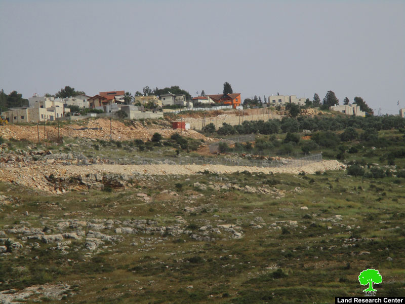
The Case of Al Walajeh
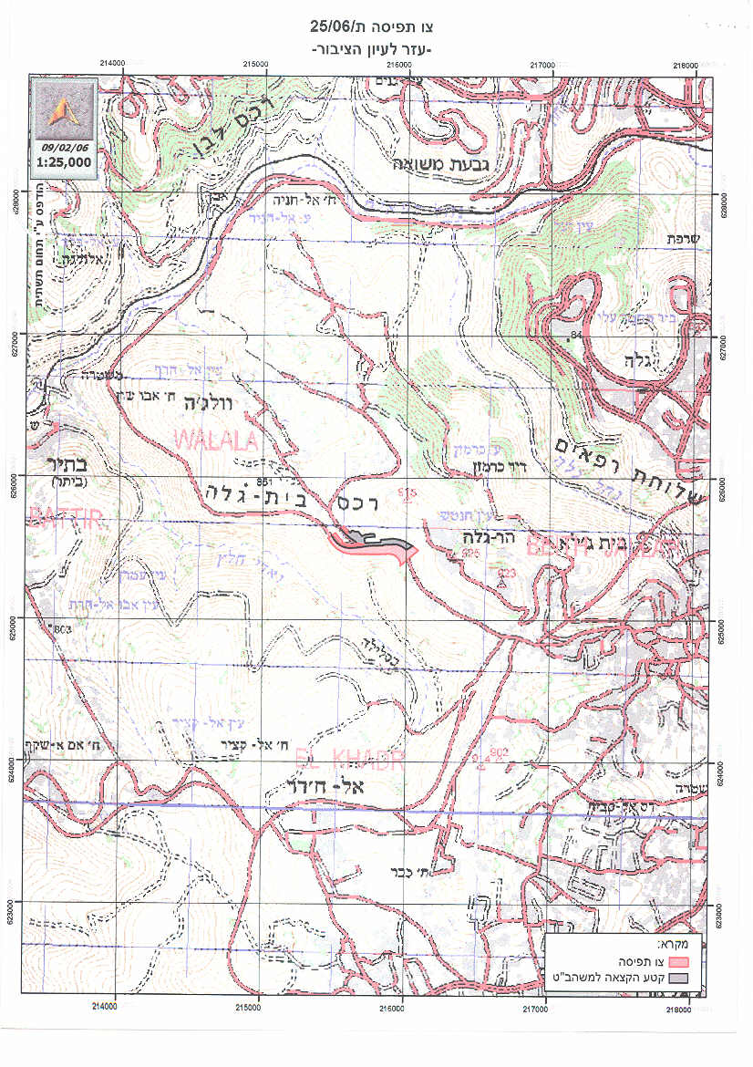
According to the Israeli Segregation Wall plan published on the IDF website on February 20, 2005, Al Walajeh village will be sealed off from three directions, east, west and north where a total of 1599 dunums of lands will be segregated behind the Wall; while the remaining 2804 dunums of Al-Walajah village lands will fall within the enclave created by the Segregation Wall under Israeli jurisdiction but on the Palestinian side of the 1949 Armistice Line west of Bethlehem. See Map 4

Map 4: Al Walajeh Village lands
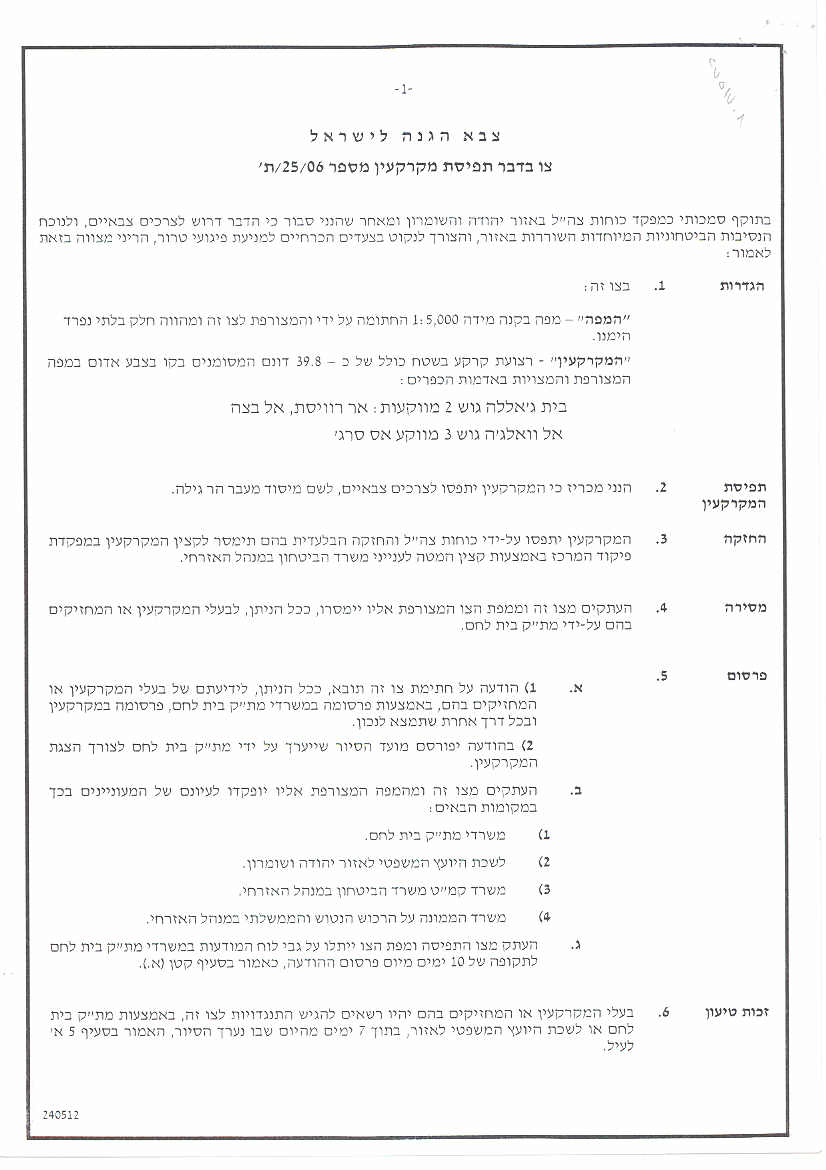
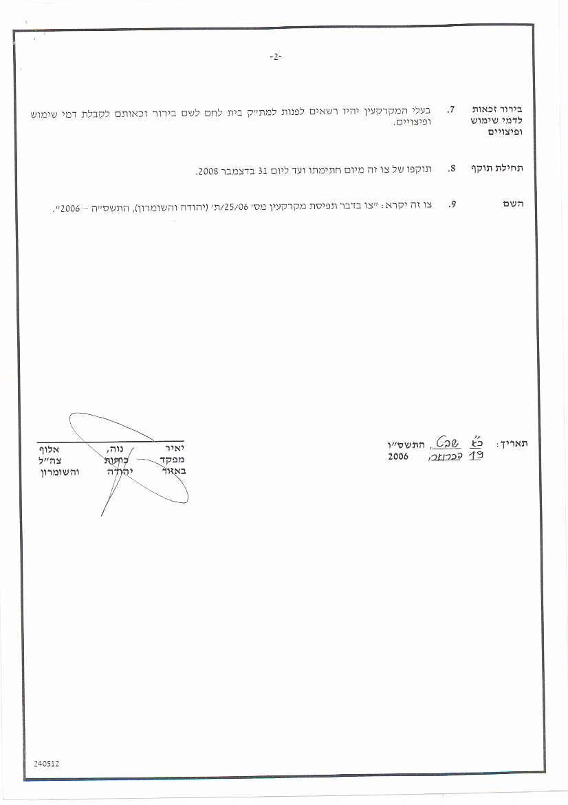
On February 19, 2006, the Israeli Occupation Forces issued a new military order number ((25/06/T (Page 1, Page 2 & Page 3)) to confiscate 39.8 dunums of lands in Al Walajeh Village for the construction of a new Border passages in the area. The Border passage was given the name 'Har Gilo Border passage' and will limit the access of Palestinians into and out of the village.
Work on constructing the border passage started a time earlier of the Israeli military announcement to construct the passage. Israeli bulldozers were and are still working till this day on the site. The military order is a complementary to the Israeli Segregation Wall plan which is being implemented on lands of the village.
The Case of Ar Ram Town and Dahiyet Al Barid
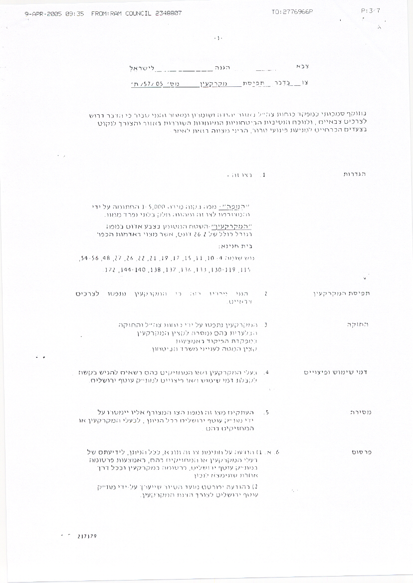
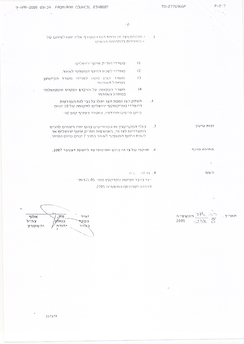
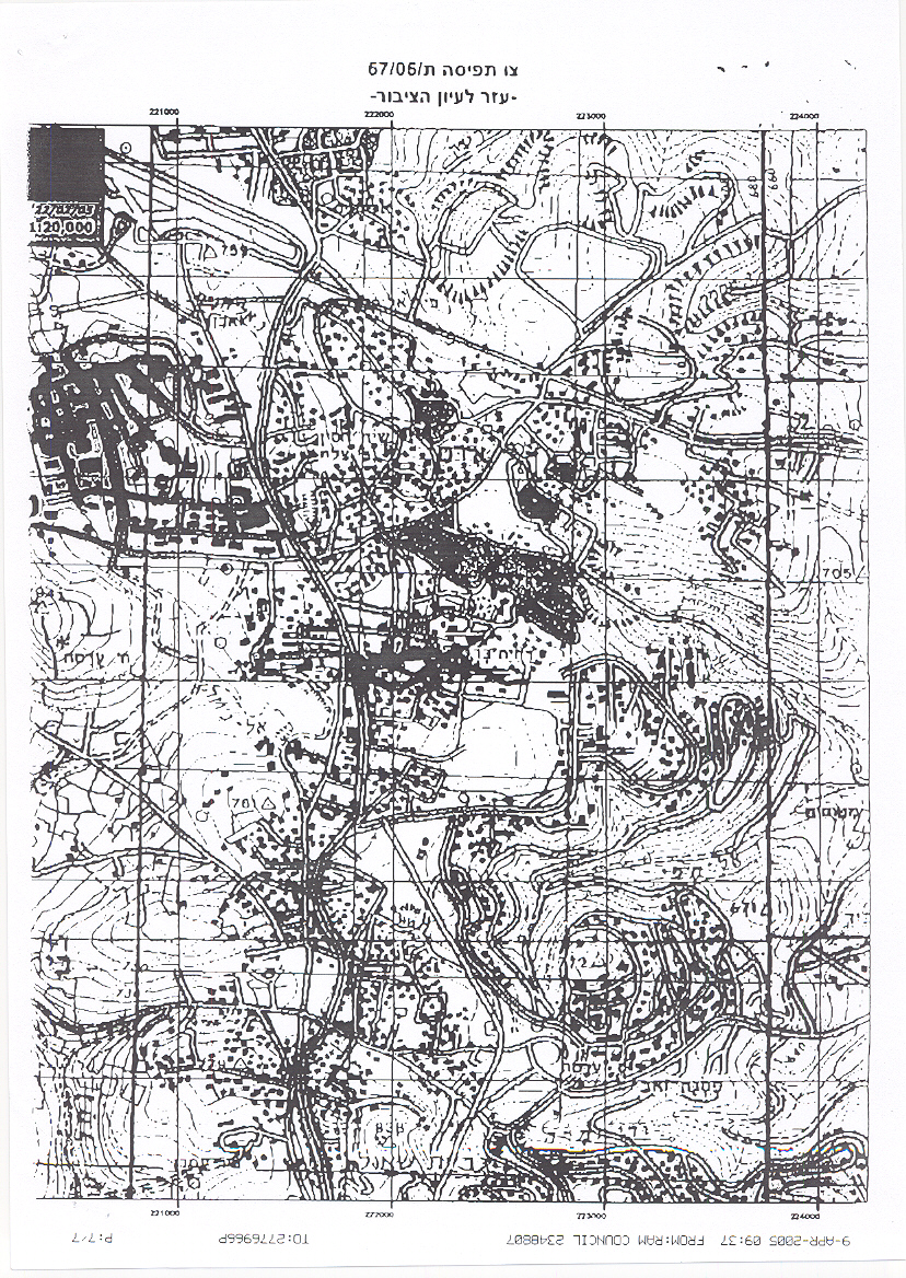
On March 2005, the Israeli occupation forces (IOF) served out residents of Dahiet Al Barid military order number (05/57/T Judea & Samaria 2005, Page 1, Page 2 & Page 3) stating the seizure of 26.2 dunums of lands to construct a new Wall section in the area. The Israeli plan intends to isolate an active part of Dahiet Al Barid from the rest of its community, Ar Ram town. The area that is going to become segregated by the Wall includes a number of educational institutions and international organizations.
On June 22, 2005, the Israeli High Court of Justice issued a temporary restraining order to stop constructions of the Segregation Wall planned in the southern part of Ar Ram Town (Dahiet Al Barid neighborhood) until discussions over petitions are heard. Few months later, on October 16, 2005, the Israeli court has approved the resumption of Wall constructions in the area, putting an end to the restraining order it issued in June 2005 for ' urgent security need' as quoted by the Israeli court.
Recently, on November 30, 2005, the Israeli authority issued an updated Wall map in Dahiyat Al Barid which included two new gates to be constructed within the path of the Wall, main and secondary gates to enable residents of Ar Ram and Dahiyat Al Barid (those who hold Jerusalem ID cards) to access Jerusalem without having to go through Qalandyia Crossing. The gates will be replacing ten Wall blocks already constructed at the end of Ar Ram – Dahiyat Al Barid main road. This Wall section, once completed will create new isolated ghettos with the same community and residents of the two areas will be cut off from each other first and from their surroundings second. See Map 5
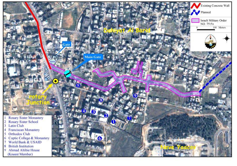
Map 5: The Segregation Wall path and Wall gates seperating Dahiyat Al Barid from Ar Ram
Third group of petitions
Table 3 lists the third group of petitions which are still under-discussion by the Israeli court and are marked with yellow on the map. Most of the petitions were raised by Palestinians living in Jerusalem towns such as Hizma, Shu'fat, 'Anata, and Beit Hanina, a number of Palestinian villages located to the northwest of Ramallah, villages located to the northwest of Jerusalem city such as Al Jib, Beir Nabala and Al Judera, and parts of Hebron Governorate. See Table 5
|
Table 5: Under-discussion complaints against the construction of the Segregation Wall In the West Bank (as translated from Hebrew) |
|||||
|
ID |
Complaint Color – as shown on map |
party |
region |
Date |
complaint No. |
|
1 |
yellow |
Beir Nabala Village Council |
Beir Nabala Beit Hanina Al Judera village Qalandyia Al Jib |
2005 |
4289/05 |
|
4457/05 |
|||||
|
2 |
yellow |
Maslamani Family and the local council of Ar Ram |
Ar Ram Town |
2004 |
5488/04 |
|
6080/04 |
|||||
|
3 |
yellow |
Maliha Family |
Dahyat Al Barid ( Al Barid Outskirt ) |
2005 |
3648/05 |
|
4 |
yellow |
Khateeb Family |
Hizma Town |
2004 |
7138/04 |
|
5 |
yellow |
Halawe Family |
'Anata Town |
2004 |
6541/04 |
|
6 |
yellow |
Hamdan Family |
'Anata town |
2004 |
7286/04 |
|
7 |
yellow |
representatives of Ras Khamees |
Shu'fat city |
2005 |
6193/05 |
|
8 |
yellow |
Sohsah and Abu Jit Families |
Shayyah city |
2005 |
6356/05 |
|
6373/05 |
|||||
|
9 |
yellow |
Salameh Family |
Sawahreh |
2004 |
1073/04 |
|
10 |
yellow |
Beit Jala Municipality |
Beit Jala City |
2004 |
7341/04 |
|
11 |
yellow |
Radad Family |
Azzawiya village |
2004 |
6027/04 |
|
12 |
yellow |
Mousa Family |
Rafat and Deir Ballut |
2004 |
6336/04 |
|
13 |
yellow |
Representatives of Shuqba village |
Kherbit Dasra |
2004 |
4938/04 |
|
14 |
yellow |
Elyan Family |
Budrus |
2004 |
4825/04 |
|
15 |
yellow |
representatives of settlement Hashmonaeem and Khwaja |
Kiryat Sefer Settlement and Ni'lin village |
2004 |
2577/04 |
|
16 |
yellow |
Naser Family |
Deir Qiddis |
2004 |
2645/04 |
|
17 |
yellow |
Anjs Family |
Kherbatha |
2004 |
2847/05 |
|
18 |
yellow |
Representatives of Bet Sira village and Mod'in settlement |
Beit Sira |
2004 |
5683/04 |
|
19 |
yellow |
Representatives of Biddu Village |
Bet Liqya Bet 'Anan Kherbet Um lahem Qatanneh Beit Surik Biddu Beit iksa Nabi Samuel |
2005 |
426/05 |
|
20 |
yellow |
Har Adar Local Council |
Har Adar settlement |
2005 |
1767/05 |
|
21 |
yellow |
Qandeel Family |
Bet Surik village |
2005 |
2223/05 |
|
22 |
yellow |
Ajriab Family |
Bet Ijza village |
2004 |
3758/04 |
|
23 |
yellow |
Hamad Family |
Ateereh |
2004 |
2986/04 |
|
24 |
yellow |
Shtayeh Family |
South of Ariel Settlement |
2005 |
1348/05 |
|
25 |
yellow |
Mansour Family |
East to Emmanuel settlement |
2005 |
2942/05 |
|
26 |
yellow |
Bozyah Family |
Overview of Ariel |
2005 |
3290/05 |
|
27 |
yellow |
Hussein Family |
Ma'ale Shomron |
2005 |
4050/05 |
|
28 |
yellow |
Municipality of Oleh |
Region of Kherbit Deir and Sheikh Madkoon |
2004 |
11430/04 |
|
29 |
yellow |
Al Rzekat Family |
Near of the check point of Tarqumyia |
2005 |
396/05 |
|
30 |
yellow |
Representatives of Bet Awa Town |
south of Tarqumyia |
2004 |
9531/04 |
|
31 |
yellow |
Representatives of Tana Settlement |
Tana |
2005 |
3680/05 |
|
32 |
yellow |
Abu Rumi Family |
Lazros netrance |
2005 |
6401/05 |
|
33 |
yellow |
Shakir Family |
Sheikh Sa'ad |
2005 |
7337/05 |
|
34 |
yellow |
Human defense association |
All parts that are not on the Green Line |
2003 |
9661/03 |
The Case of Beit Sira
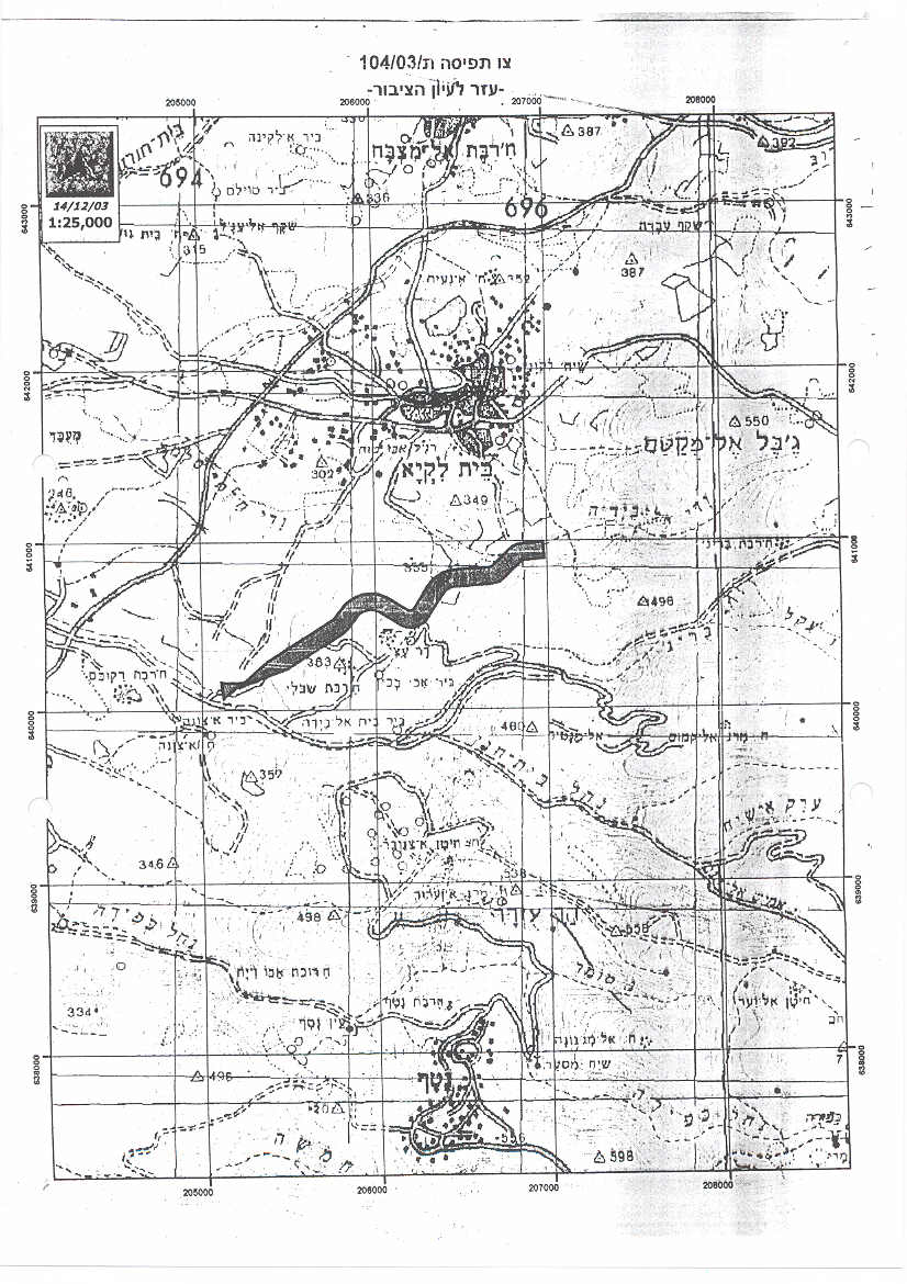
Beit Sira is a Palestinian village located 22 Km southwest of Ramallah district and houses a total population of 2744 residents – PCBS population projection 2005. On December 14, 2003, the Israeli Army issued military order # (03/104/T) to seize 149 Dunums of Beit Sira village lands for erecting the segregation Wall. The order was just a segment of the segregation Wall in that area which penetrates Beit Sira's lands. However, the order was yet to include a supplementary order to split the village literally into two parts. As residents of Beit Sira elevated the level of protest against the Israeli segregation Wall, the latter, temporarily stopped the (03/104/T) seizure order to re-evaluate the route of the segregation Wall in the area.
Later on June 24, 2004, the Israeli Army issued another military order # (03/105/T) categorized as (Border Amendment) where a shift in the route of the segregation Wall was apparent westward of Beit Sira built-up area. The segregation Wall's new route sets along the marked-line of the 'No Man's land' area and the Latrun road. Furthermore, the route of the segregation Wall in military order # (03/105/T) will consume 222 Dunums of Beit Sira's agricultural lands in addition to the isolation of 1945 Dunums that will be segregated behind the wall.
On February 20, 2005, the Israeli Ministry of Defense published an updated wall plan which suggested some changes in the wall route in West Bank cities and villages. Beit Sira was one of the villages that witnessed a change in wall route but it wasn't at favor of the Palestinian residents in the village since the wall will run a length of 2.5 km along the village's lands, from north to south, and will cause the segregation of 2973 dunums west of it, an area which is quite larger than that of June 2004. Already 0.5 km wall are under construction in Beit Sira village while the other 2 are planned to be constructed.
The Wall around Ariel
In the year 2003, the Israeli authorities and under security claims decided to construct a Segregation Wall around Ariel settlement bloc in Salfit Governorate (a bloc of 26 Israeli settlements). Since then, the Israeli bulldozers razed vast areas of lands and uprooted many fruitful trees. The Israeli Supreme court halted the construction of the Wall in the area several times due to petitions raised to the court by Palestinian residents of the nearby villages of Iskaka, Marda and Az Zawiya. In September 2005, the Israeli deputy defense Ze'ev Boi'm said that the construction of the so called 'Ariel Finger' east of Ariel settlement bloc must be constructed as soon as possible. 'Ariel finger' is the deepest incursion for the Israeli Segregation Wall inside the West Bank, as it goes deep as 22 km. The Wall around Ariel bloc stretches for 114 km and grabs within it 120,000 dunums of lands which is larger than the area the other settlement blocs encompass.
The Wall in International law:-
The Israeli Segregation Wall has harsh impacts on the Palestinian society, especially that it cuts off the agricultural lands from its owners, and deprives them their living; thus affecting the economic situation. The Wall also restricts the movement of Palestinians and extends to affect all aspects of life.
The construction of the Segregation Wall is a blatant violation of International law and UN resolutions:
Fourth Geneva Conventions, Article 53: Any destruction by the Occupying Power of real or personal property belonging individually or collectively to private persons, or to the State, or to other public authorities, or to social or cooperative organizations, is prohibited, except where such destruction is rendered absolutely necessary by military operations.
Fourth Geneva Conventions, Article 33:
-
No protected person may be punished for an offence he or she has not personally committed. Collective penalties and likewise all measures of intimidation or of terrorism are prohibited.
-
Pillage is prohibited.
-
Reprisals against protected persons and their property are prohibited.
The Wall also violates the International Covenant on Civil and Political Rights and the International Covenant on Economical, Social, and Cultural Rights both of which Israel has signed.
The International Covenant on Civil and Political Rights (ICCPR) – Property (ICCPR, article 1): All peoples have the right of self-determination. By virtue of that right they freely determine their political status and freely pursue their economic, social and cultural development.
The International Covenant on Economic, Social and Cultural Rights (ICESCR) – health (ICESCR, article 12): The States Parties to the present Covenant recognize the right of everyone to the enjoyment of the highest attainable standard of physical and mental health.
The International Covenant on Economic, Social and Cultural Rights (ICESCR) – Education (ICESCR, art.13: The States Parties to the present Covenant recognize the right of everyone to education. They agree that education shall be directed to the full development of the human personality and the sense of its dignity, and shall strengthen the respect for human rights and fundamental freedoms.
The International Covenant on Economic, Social and Cultural Rights (ICESCR) – Food (ICESCR, art. 11): The States Parties to the present Covenant recognize the right of everyone to an adequate standard of living for himself and his family, including adequate food, clothing and housing, and to the continuous improvement of living conditions. The States Parties will take appropriate steps to ensure the realization of this right, recognizing to this effect the essential importance of international co-operation based on free consent.
Related Links
-
Apartheid is alive: The confinement of ‘Anata and Shu’ufat refugee camp in an enclave.
-
The Segregation Wall seized more lands of Beit Surik Village!!!
Prepared by:
The Applied Research Institute – Jerusalem


