Since the eruption of the second Intifada on September 28, 2000, a series of violations of land razing and house demolitions have been committed by the Israeli Occupying forces in the Occupied Palestinian Territory. The Israeli Occupying forces (IOF) have committed severe attacks against Palestinian residents and their properties where thousands of Palestinian residents have been made homeless with poor living conditions. These harassments caused devastating damages to the Palestinian livelihood.
Israel usually justifies the destruction of Palestinian houses by claiming that it is for 'security needs' or for “building without a license”. In the same time the Israeli authorities impose hard restrictions on planning and construction which require Palestinians to go through a lengthy and costly process to apply for building licenses for constructing a new structure or renovating an existing one, which frequently ends in denial to give the permit, particularly for the ones located in Area C (Under the control of the Israeli authority).
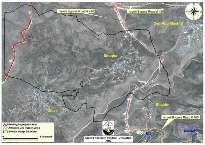
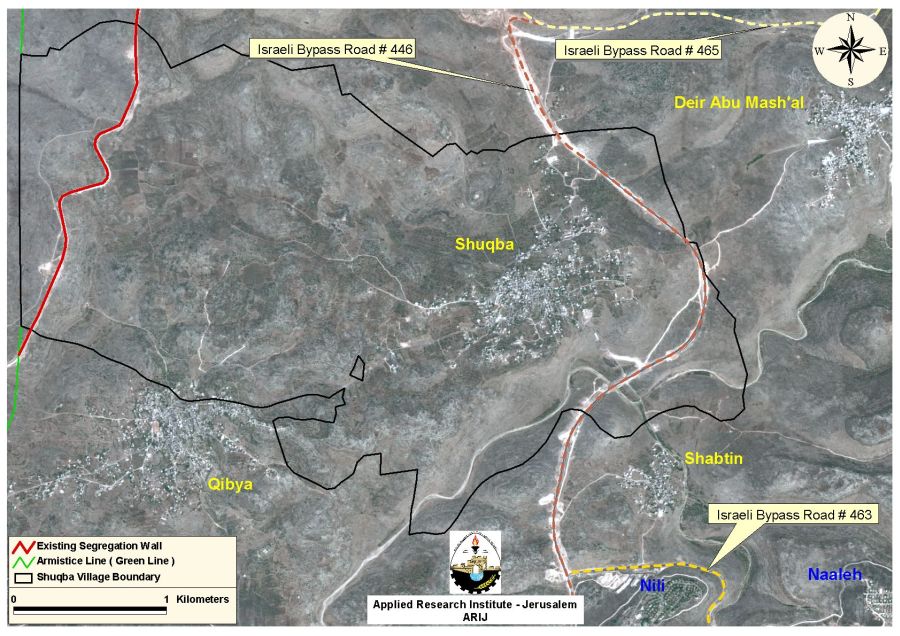
Shuqba
Shuqba village is located 17.71 Km northwest of Ramallah city and its built up area is located about 3.8 Kilometers away from the Green Line (Armistice Line). It has a total area of 130,990 dunums and the built-up area comprises 616 dunums. The village is home for 4,439 inhabitants and is bounded from the southwest by the Palestinian village of Qibya, from the south east Shabatin, from the northeast by Deir Abu Mish'al and from the north by the illegal Israeli settlement of Ofarim.
The Israeli practices in Shuqba village
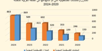
Israel usually confiscates and razes agricultural lands and fruitful trees throughout the Palestinian Territory claiming that the confiscation of the land is necessary for 'security needs.' But actually, most land confiscating operations facilitate the expansion of illegal Israeli settlements and by-pass roads and most of all the construction of the Segregation Wall. The Israeli authorities issued several numbers of military orders to confiscate lands in Shuqba and in the nearby villages. On October 14, 2003, the Israeli army issued military order # (69/03/T) to confiscate 862 dunums of lands in the villages of Shuqba, Burdus, Qibya, and Rantis for the Segregation Wall process. Moreover, another order holding number (26/04/T) was issued on July 4, 2004, to confiscate 121.4 dunums of lands from Shuqba village for the same reason. It is worth mentioning that the total length of the Segregation Wall path that currently exists in the village of Shuqba is 3 kilometers and caused the isolation of 1160 dunums.
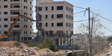
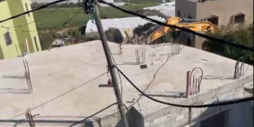
Furthermore, on February 8, 2006, a large number of Israeli troops accompanied by huge bulldozers staged into the small village of Shuqba and demolished five Palestinian houses owned by 'Abed El 'Azez Qadeh, Mustafa Muhammad Qadeh, Najeh 'Ali Qadeh, Muhammad Fakhry and Mahmoud Yunis conducted under the pretext of being constructed outside the village Master Plan, whereby the house of Ahmad 'Abed El Hamid which is located in the same area is threatened of being demolished under the same purposes. See Map of Shuqba Village
This Israeli offensive attack on Shuqba village is one of the planned series of attacks aiming at evacuating the Palestinian residents from their lands and houses. It is worth mentioning that the Israeli attacks breach the fourth Geneva Convention of 1949 ''article 53 which states that: ' Any destruction by the Occupying Power of real or personal property belonging individually or collectively to private persons, or to the State, or to other public authorities, or to social or cooperative organizations, is prohibited, except where such destruction is rendered absolutely necessary by military operations.'
Bypass Road 446 in Shuqba Village
In addition, Shuqba village is bordered from its eastern part by bypass Road number 446 which also cuts and isolates 932 dunums of its lands. This road runs by Beit Arye settlement north of Ramallah Governorate and connects with the settlements of Nili, Modin Illit settlement bloc which include: Mattiyahu, Hashmonaim, Menora, Lapid, Kfar Rut and Shilta which lie on the same line of the road. The bypass road then extends to connect with other bypass Roads in the Governorate such as Roads number 465, 463 and 443. According to the Forbidden roads report done by B'Tselem, Palestinians are completely prohibited from accessing this bypass road. During the last five years, Israel extended its restrictions on freedom of movement for the Palestinian residents; these violation measures breach all international human rights and laws.
Conclusion
In the time Israel is confiscating the Palestinian agricultural lands in order to expand the illegal settlements of the West Bank by constructing hundreds of thousands of housing units to settle more and more of the Israeli settlers, the Israeli authority demolishes the Palestinian houses under the pretext of being constructed without building licenses to clear vast areas of lands, as a result hundreds of Palestinian families become homeless with no place to live.
References
-
'International Humanitarian Law – Treaties & Documents.' Convention (IV) relative to the Protection of Civilian Persons in Time of War. Geneva, 12 August 1949.. International Committee of the Red Cross . 12 August 1948 .
Prepared by:
The Applied Research Institute – Jerusalem