Introduction
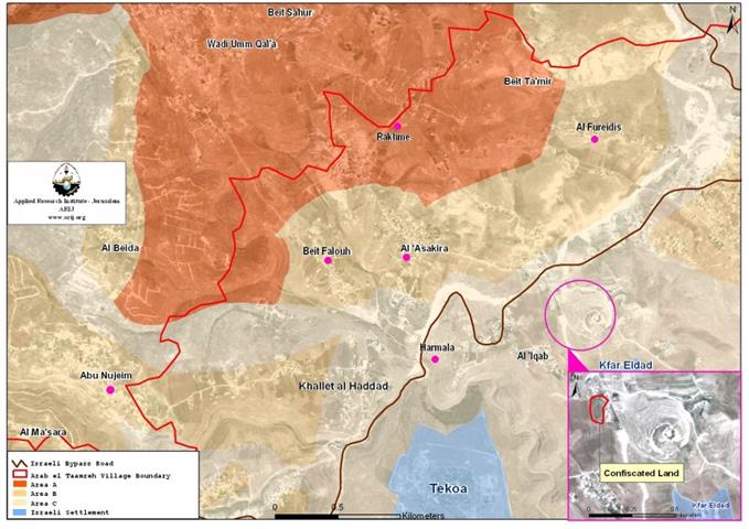
JANNATA is an assembly of Palestinian villages/communities, located south of Bethlehem city, in the southern part of the West Bank. It is bordered by Wadi Rahhal to the west, Hindaza and Bethlehem to the north, Al Ma'sara to the south and Beit Tamir and Za'tara from the east. Jannata village constitutes of six small communities: Al 'Asakira, Rakhma, Abu-Njam, Harmallah, AL-Fradees, Betfalug. In 1996, the Palestinian National Authority allied these communities in one municipality called Jannata for facilitating the provision of services and planning for these communities. The total area of Jannata reaches to 8000 dunums and the built up area is approximately 1760dunums, distributed among the six communities. The total number of its citizens reaches approximately 4550 people, (Projected Mid-year Population for Bethlehem Governorate by Locality 2001-2007), also distributed on the six villages. (See Table 1).
Table 1: The Six Communites of Janata Area.
|
Population |
Built up area- (Dunum) |
|
| Al-Asakira |
971 |
288 |
| Rakhma |
899 |
269 |
| Abu Njam |
759 |
158 |
| Harmallah |
734 |
217 |
| Al Furdeis |
694 |
323 |
| Betfalug |
493 |
505
|
| Total |
4550 |
1760 |
According to the Oslo II Agreement and land classification, Rakhma village lands are classified as Area A, that is area under full Palestinian control; Al-Asakira, Betfaluh, Abu-Njam and Fradees are classified as area B, which means that the Palestinian Authority has full control over the civil administration and Israel, continues to have overriding responsibility for security; as for Harmallah, its lands are classified as area C, where Israel retains full control. See Map 1

Before 1967, Jannata communities depended on dry land agriculture and animal breeding for their livelihood. However, Jannata municipality reported to ARIJ fieldworkers that during the seventies till the late nineties many of the residents of the village started to work in Israel. But the outbreak of the Intifada in September 2000 and the Israel imposed closures and restrictions on mobility of the Palestinian residents prevented the majority of the workers from reaching their work in Israel, where 70% of the workers lost their jobs which lead to a noticeable rise in the unemployment rate. Jannata municipality reported also that the working force of Jannata is engaged in the following sectors:
-
25% of the working force is in agriculture;
-
70% of the working force is in construction works in Israel;
-
and 5% of the working force is in governmental sectors.
The municipality indicated that today the people in Jannata reverted to work in agriculture or as employees in the services sector, and that still, the dominant economic base in the village is dependant on agriculture.
In Jannata, there are four schools and three kindergartens in addition to one hospital which is a Military Hospital and two governmental clinics based in Harmallah which provide health care and services.
The Violation:
On February 25, 2006, Israeli bulldozers protected by the Israeli army, razed without prior notification, four dunums of land owned by Sa`ed Salame Askar from Jannata and uprooted 6 pine trees, 15 olive trees and 4 almond trees. See Photo 1 and Photo 2.
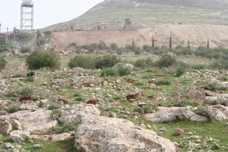

Photo 1 & Photo 2: Israeli Bulldozers working close to
Herodeon Israeli Military Camp & : Israeli Bulldozers working close to Herodeon Israeli Military Camp
The land lies to the northwest of Harmallah village in an area classified as C (lands under full Israeli control).The attacked land is also located near Herodeon Israeli military Camp. This camp has the capacity to enclose more than one thousand soldiers, and inside it there are dozens of tanks and troop carrier vehicles, (Al Quds newspaper, February 25, 2006).
Mr. Saed Salameh Askar (the land owner) indicated that his land faced three Israeli attempts to appropriate it. The first attempt was in the year 1987, when an Israeli developer tried to create a public garden on his land and the lands around the Herodeon Mountain, but the land owner started a judicial battle that ended in his favor,, thus setting back the Israeli plan.
The second Israeli attempt was in 1992, when the Israeli authorities started opening a street near the land, which would undermine agricultural use and character of the area. The land owner submitted an objection to Israeli Court which ruled to cease the road work.
The third attempt was in November 22, 2005, when the owner of the land received military order # T /19/95 which specified the seizure of the land until the year 2010, for military reasons and to expand Herodeon military camp. In February 25, the Israeli authorities have started to bulldoze the land..
Finally Israel still adopts its aggression and violence policy towards the Palestinians in Jannata and in all the Palestinian villages and cities in the West Bank and Gaza Strip, aiming to displace and isolate the Palestinians from their lands .
Under the Universal Declaration of Human Rights Adopted and proclaimed by General Assembly resolution 217 A (III) of, December 10, 1948, Article 17 reads: 'No one shall be arbitrarily deprived of his property.' Which means it bans Israel from destroying or confiscating the property of the Palestinians at any case.
References:
-
'Palestinian Central Bureau of Statistics.' http://www.pcbs.org/. 25 Feb 2006.
-
Universal Declaration of Human Rights 07 Mar. 2006 <http://www.un.org/Overview/rights.html>.
Prepared by:
The Applied Research Institute – Jerusalem