On November 30, 2005, the Israeli court issued an updated map of the Wall section in Dahiyet Al Barid which showed two Wall gates, main and secondary, to be constructed within the Wall path which is currently under-construction in the area. The gates are to enable residents of Ar Ram and Dahiyet Al Barid, those who hold Jerusalem ID cards to access Jerusalem without having to go through Qalandyia Border Crossing. The gates will be replacing ten wall blocks already constructed and are part of the main Qalandyia-Ar Ram wall, to the west of Dahiyet Al Barid area, which Israel intends to demolish in order to erect those two new gates. See Map 1
Dahiyet-Al-Barid (Al Barid Outskirt) is a Palestinian neighborhood located to the south of Ar Ram town. It is bounded by an Israeli military base and the settlement of Pisgat Ze'ev from the south, the settlement of Neve Ya'acov from the southeast, the settlement of Adam (Giv'at Binyamin) from the east and the Palestinian community Beit Hanina from the west, see Table 1 and Map 1. Geographically speaking, Dahiyet Al Barid is connected to Ar Ram town and is considered as part of it.
|
Settlement Name |
Governorate |
Date of Establishment |
Area in dunums |
|
Neve Yaacov |
Jerusalem |
1972 |
1,240 |
|
Adam ( Geva Benyamin) |
Jerusalem |
1983 |
1,195 |
|
Military Base |
Jerusalem |
|
|
The neighborhood is a home to 24,838 Palestinians according to the Palestinian central Bureau of Statistics 2005, where the majority of its citizens hold Jerusalem ID cards. , where the majority of its citizens hold Jerusalem ID cards.
The Chronology of events in Dahyiat Al Barid:-
Works on constructing the Segregation Wall between Dahiyat Al Barid and Ar Ram started during the current year – 2005.
The impaired Dahiyat Al Barid will suffer once the Wall is completed on its lands, as part of the neighborhood will be detached from the remainder and from Ar Ram town and will be placed behind the Wall, as well as the isolation of Al Ram and Dhiyet Al Barid from the neighboring Palestinian communities located to its west such as Beir Nabala, Al Jib, Al-Judera, Beit Hanina al-Balad and the definite loss of connection with Jerusalem. It is worth mentioning that Dahiyat Al Barid and Ar Ram have developed the commercial and social sectors during the previous years; mainly due to the strict Israeli measures imposed on Palestinians to access Jerusalem and its institutions. In addition, this wall section will restrict residents' movement to Jerusalem and Ramallah districts too.
According to the Israeli ministry of defense map of October 2003, the path of the Segregation Wall was supposed to be constructed along the illegal Jerusalem Municipal boundaries set following the occupation of East Jerusalem in 1967 where the two communities Ar Ram and Dahiyat Al Barid were excluded from Jerusalem, only few houses from Dahiyat Al Barid were included. Residents of Dahiyet Al Barid along with the international organization and religious institutions situate there objected the route of the wall and filed petitions to the Israeli court demanding a shift in Wall route as to include them within Jerusalem city boundaries.
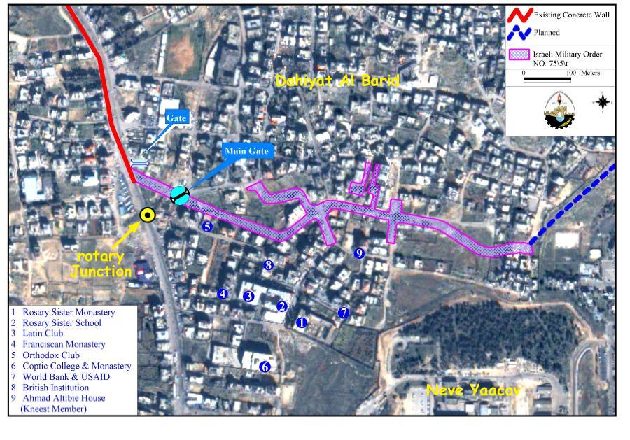
On February 20, 2005, the Israeli ministry of defense issued an updated Wall map which included a shift in the Wall route in the area of Dahiyat Al Barid. About 100 houses and buildings including a number of national and international institutions such as the Rosary Sister school, the Rosary Sister Monastery, the Franciscan Monastery, The Latin Club, The Coptic collage monasteries, the Greek Orthodox club, The World Bank, the British Institution where within the boundaries of Jerusalem while cutting it off from the remainder of the neighborhood and Ar Ram Town. See Map 2
Followed on March 8, 2005, the Israeli occupying forces served the communities of Dahiyet Al Barid and Ar Ram a military order numbered (05/57/T Judea & Samaria 2005) to confiscate 26.2 dunums of land to make a way for the new Wall section of February 2005 map to be constructed in the area. Accordingly, the Wall will break through the residential houses cutting between the close neighbors and separating the house from its garden; consequently , Dahiet Al Barid will be divided into two totally separated parts.
This military order has grave impacts on the affected communities in that:
-
About 100 houses and buildings including the organizational and religious intuitions are laid on the Municipal Jerusalem side of the Wall and are segregated from the rest of Dahiyat Al Barid community and Ar Ram town.
-
More than 90% of the residents living in the remaining segregated community of Dahiyat Al Barid and Ar Ram town hold Jerusalem ID Cards and they will be severely affected when accessing Jerusalem city as they will have to go through Qalandyia crossing border to be able to access the city; thus increasing the pace of hardship on them.
-
Being excluded from Jerusalem city although hold Jerusalem ID cards threatens residents' residency rights. As Palestinian Jerusalemites living outside the Jerusalem municipal boundaries, they are threatened of losing their residency rights in Jerusalem if they continue to live in a territory outside Jerusalem. Therefore, residents of the two areas will have to choose (in the near future) between continuing to live in their house or move to live inside Jerusalem as not to have their residency rights revoked under the slogan 'center of life' obligation.
-
There are a number of Palestinian houses within the 100 houses that were situated on the Municipal Jerusalem side of the Wall and hold West Bank ID cards. Residents of these houses are threatened of leaving their houses to live on the other side of the Wall due to their status as West Bank Residents, or these families will be given long term permits as to enable them to move freely within the neighborhood without having to leave their houses.
On June 22, 2005, the Israeli High Court of Justice issued a temporary restraining order halting Wall constructions in the area between Dahiyat Al Barid and Ar Ram town as a response to the petition filed by local inhabitants and organizations until a decision is reached. According to the maps provided, the Wall is to break through the residential houses and divide the neighborhood into two parts.
Later on Sunday, October 16, 2005 the Israeli Supreme court cancelled the restraining order on the Wall construction in this area. According to the court, the resumption of work in this Wall section came for security reasons as quoted from Haaretz daily news paper: 'there is an urgent security need to complete the creation of the fence in this area in order to prevent the entry of terrorists into the State of Israel.' Haaretz Daily News Paper.
The status of the Segregation Wall in the areas surrounding Dahiyet Al Barid and Ar Ram Communities
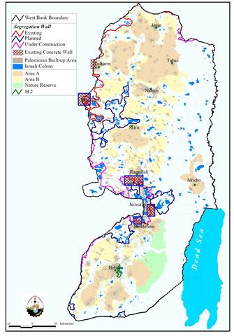
The Wall in Dahiyat Al Barid and Ar Ram communities is part of the so called Jerusalem Envelope which is planned to run for 190 km around the city of Jerusalem.
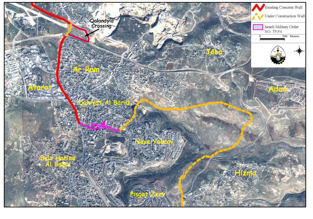
The planned route of the Segregation Wall surrounds Ar Ram and Dahiyat al Barid neighborhoods from three sides. The Israeli authorities' have already completed the construction of 5-6 meters-high concrete Wall running from Qalandiya down the middle of the Jerusalem-Ramallah main road and reaches to Dahiyet Al Barid junction. This Wall section ending at Dahiyet Al Barid Junction will be linked to one secondary gate planned to be constructed within the path of the Wall along the main Ramallah-Jerusalem road, and then continues to penetrate into Dahiyat Al Barid lands to then connect to another main Wall Gate also planned to be constructed in the area as to avoid rush-hour traffic to Jerusalem, to finally be connected with the Wall section being constructed east of Dahiyat Al Barid separating it from Hizma village lands. See Map 1
From the West , the wall separates the area of Dahiyat Al Barid and Ar Ram town from 'Atarot industrial zone and the northwest Jerusalem villages of Beir Nabala, Al Jib, Al Judera and Beit Hanina.
, the wall separates the area of Dahiyat Al Barid and Ar Ram town from 'Atarot industrial zone and the northwest Jerusalem villages of Beir Nabala, Al Jib, Al Judera and Beit Hanina.
From the east and southeast, the wall is under construction and stretches 3 km towards the east and connects with the part of the wall already constructed west of Hizma village lands. This wall section will cause the separation of both communities from their open extensions in the east, at the same time annexing the settlement of Neve Yaacov, Pisgat Ze'ev, Pisgat 'Amir, to Jerusalem. See Map 2
Conclusion
The systematic nature of Israel's occupation policies (including the Segregation Wall) submits it to a further violation to the Human Rights and international law. Israel's military occupation and the accompanying policies it enforces in the Occupied Palestinian Territory (OPT) comprise a crime of apartheid according to the International Convention on the Suppression and Punishment of the Crime of Apartheid (1973) which defines apartheid as: 'the imposition of various legislative measures on different racial groups while injuring the rights of one. Moreover, the crime of Apartheid comprises a 'crime against humanity' and 'a serious threat to international peace and security.
Hague Regulations 1907 Section II Article 23: [it is especially forbidden] to destroy or seize the enemy's property, unless such destruction or seizure be imperatively demanded by the necessities of war.
Hague Regulations 1907 Section III Article 46: 'Family honor and rights, the lives of persons, and private property, as well as religious convictions and practice must be respected. Private property cannot be confiscated.'
Fourth Geneva Conventions
Article 32: A protected persons shall not be have done to them anything of such a character as to cause the physical suffering or extermination … the physical suffering or extermination of protected persons in their hands. This prohibition applies not only to murder, torture, corporal punishments, mutilation and medical or scientific experiments not necessitated by the medical treatment
Article 33:
1. No protected person may be punished for an offence he or she has not personally committed. Collective penalties and likewise all measures of intimidation or of terrorism are prohibited.
2. Pillage is prohibited.
3. Reprisals against protected persons and their property are prohibited.
4. The Wall also violates the International Covenant on Civil and Political Rights and the International Covenant on Economical, Social, and Cultural Rights both of which Israel has signed.
Article 49: 'The occupying power shall not deport or transfer parts of its own population into the territories it occupies.'
Article 53: 'Any destruction by the Occupying Power of real or personal property belonging individually or collectively to private persons, or to the State, or to other public authorities, or to social or cooperative organizations, is prohibited, except where such destruction is rendered absolutely necessary by military operations.'
Article 147: 'Grave breaches to which the preceding Article relates shall be those involving any of the following acts, if committed against persons or property protected by the present Convention: willful killing, torture or inhuman treatment, including biological experiments, willfully causing great suffering or serious injury to body or health, unlawful deportation or transfer or unlawful confinement of a protected person, compelling a protected person to serve in the forces of a hostile Power, or willfully depriving a protected person of the rights of fair and regular trial prescribed in the present Convention, taking of hostages and extensive destruction and appropriation of property, not justified by military necessity and carried out unlawfully and wantonly.'
Prepared by
The Applied Research Institute – Jerusalem
ARIJ